Bridge Statistics for West Milford, West Virginia (WV)
Condition, Traffic, Stress, Structural Evaluation, Project Costs
- National Bridge Inventory (NBI) Statistics
- 10Number of bridges
- 131ft / 40.3mTotal length
- $4,460,000Total costs
- 16,150Total average daily traffic
- 960Total average daily truck traffic
- 21,205Total future (year 2038) average daily traffic
- National Bridge Inventory (NBI) Registered Bridges for West Milford
- No street view available for this location
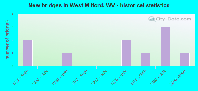
- New bridges - historical statistics
- 21920-1929
- 11940-1949
- 21970-1979
- 11980-1989
- 31990-1999
- 12000-2009


- Bridge Condition - Deck
- 42.9%Good
- 28.6%Satisfactory
- 14.3%Fair
- 14.3%Poor

- Bridge Condition - Superstructure
- 25.0%Very good
- 37.5%Good
- 25.0%Fair
- 12.5%Poor

- Bridge Condition - Substructure
- 50.0%Good
- 12.5%Satisfactory
- 37.5%Fair

- Bridge Condition - Channel
- 20.0%Very good
- 30.0%Good
- 10.0%Satisfactory
- 30.0%Fair
- 10.0%Poor

- Bridge Condition - Culverts
- 50.0%Fair
- 50.0%Poor
Find on map >> Show street view
Structure Number: 17A069, Location: 0.07 MI NORTH CO RT 19/17 (Lat: 39.176581, Lng: -80.438969), Route carried "on" structure: US 1900, Year Built: 1988, Status: Open, Structure Length: 4.75m (15.58ft), Average Daily Traffic: 2,000 (year 2018), Truck Traffic: 7%, Average Future Daily Traffic: 2,625 (year 2038), Design Load: HS 20, Features Intersected: WEST FORK RIVER, Facility Carried by Structure: US ROUTE 19
Minimum Vertical Clearance: 30+ m (98+ ft), Kilometerpoint: 7.226, Lanes on structure: 2, Owner: State Highway Agency, Approaching Roadway Width: 8.2m (26.9ft), Material/Design: Steel continuous, Design/Construction: Stringer/Multi-beam, Number Of Spans In Main Unit: 2, Length of Maximum Span: 23.2m (76.1ft), Curb-To-Curb Width: 8.8m (28.9ft), Out-to-Out Width: 9.8m (32.2ft)
Condition: Deck: Good, Superstructure: Good, Substructure: Good, Channel: Good, Operating Rating: 88.9 metric tons, Method Used To Determine Operating Rating: Load Factor (LF), Inventory Rating: 59.0 metric tons, Method Used To Determine Inventory Rating: Load Factor (LF), Structural Evaluation: Better than present minimum criteria, Deck Geometry: Somewhat better than minimum adequacy, Waterway Adequacy: Equal to present desirable criteria, Approach Roadway Alignment: Better than present minimum criteria, Designated Inspection Frequency: Every 48 months, Underwater Inspection Frequency: Every 60 months, Inspection Date: April 2020, Underwater Inspection Date: July 2018, Deck Structure Type: Concrete Cast-file-Place, Wearing Surface/Protective System: Deck Protection: Epoxy Coated Reinforcing
Find on map >> Show street view
Structure Number: 17A072, Location: 0.17 MI NORTH CO RT 19/62 (Lat: 39.183111, Lng: -80.439600), Route carried "on" structure: US 1900, Year Built: 1924, Status: Open, Structure Length: 0.68m (2.23ft), Average Daily Traffic: 2,700 (year 2018), Truck Traffic: 7%, Average Future Daily Traffic: 3,525 (year 2038), Features Intersected: BR. OF WEST FORK RIVER, Facility Carried by Structure: US ROUTE 19
Minimum Vertical Clearance: 30+ m (98+ ft), Kilometerpoint: 8.095, Lanes on structure: 2, Owner: State Highway Agency, Approaching Roadway Width: 7.3m (24.0ft), Skew: 4 degrees, Material/Design: Concrete, Design/Construction: Slab, Number Of Spans In Main Unit: 1, Length of Maximum Span: 6.3m (20.7ft), Curb-To-Curb Width: 7.1m (23.3ft), Out-to-Out Width: 8.1m (26.6ft)
Condition: Deck: Fair, Superstructure: Fair, Substructure: Fair, Channel: Satisfactory, Operating Rating: 63.5 metric tons, Method Used To Determine Operating Rating: Field evaluation and documented engineering judgment, Inventory Rating: 29.0 metric tons, Method Used To Determine Inventory Rating: Field evaluation and documented engineering judgment, Structural Evaluation: Somewhat better than minimum adequacy, Deck Geometry: High priority of replacement, Waterway Adequacy: Equal to present desirable criteria, Approach Roadway Alignment: Equal to present desirable criteria, Length Of Structure Improvement: 0.91m (2.99ft), Designated Inspection Frequency: Every 24 months, Inspection Date: Febuary 2020, Bridge Improvement Cost: $238,000, Roadway Improvement Cost: $181,000, Total Project Cost: $453,000 ( Estimate for 2020), Deck Structure Type: Concrete Cast-file-Place, Wearing Surface/Protective System: Wearing Surface: Bituminous
Find on map >> Show street view
Structure Number: 17A073, Location: 0.02 MI SOUTH CO RT 33 (Lat: 39.226369, Lng: -80.406781), Route carried "on" structure: US 1900, Year Built: 1925, Status: Open, Structure Length: 0.81m (2.66ft), Average Daily Traffic: 3,100 (year 2018), Truck Traffic: 7%, Average Future Daily Traffic: 4,050 (year 2038), Features Intersected: SYCAMORE CREEK, Facility Carried by Structure: US ROUTE 19
Minimum Vertical Clearance: 30+ m (98+ ft), Kilometerpoint: 15.498, Lanes on structure: 2, Owner: State Highway Agency, Approaching Roadway Width: 8.5m (27.9ft), Skew: 3 degrees, Material/Design: Concrete, Design/Construction: Arch - Deck, Number Of Spans In Main Unit: 1, Length of Maximum Span: 8.1m (26.6ft), Curb or Sidewalk Widths: Left: 0.1m (0.3ft), Right: 0.1m (0.3ft), Curb-To-Curb Width: 7.2m (23.6ft), Out-to-Out Width: 7.6m (24.9ft)
Condition: Superstructure: Poor, Substructure: Fair, Channel: Fair, Operating Rating: 57.1 metric tons, Method Used To Determine Operating Rating: Field evaluation and documented engineering judgment, Inventory Rating: 26.3 metric tons, Method Used To Determine Inventory Rating: Field evaluation and documented engineering judgment, Structural Evaluation: Meets minimum limits, Deck Geometry: High priority of replacement, Waterway Adequacy: Equal to present desirable criteria, Approach Roadway Alignment: Better than present minimum criteria, Length Of Structure Improvement: 1.62m (5.31ft), Designated Inspection Frequency: Every 24 months, Inspection Date: March 2020, Bridge Improvement Cost: $398,000, Roadway Improvement Cost: $362,000, Total Project Cost: $924,000 ( Estimate for 2020)
Find on map >> Show street view
Structure Number: 17A153, Location: 0.11 MI EAST CO RT 36 (Lat: 39.198981, Lng: -80.404139), Route carried "on" structure: State highway 27000, Year Built: 1979, Status: Open, Structure Length: 8.63m (28.31ft), Average Daily Traffic: 3,100 (year 2018), Truck Traffic: 4%, Average Future Daily Traffic: 4,050 (year 2038), Design Load: HS 20, Features Intersected: WEST FORK RIVER, Facility Carried by Structure: WV 270
Minimum Vertical Clearance: 30+ m (98+ ft), Kilometerpoint: 1.175, Lanes on structure: 2, Owner: State Highway Agency, Approaching Roadway Width: 6.7m (22.0ft), Material/Design: Steel continuous, Design/Construction: Stringer/Multi-beam, Number Of Spans In Main Unit: 1, Number Of Approach Spans: 2, Length of Maximum Span: 34.7m (113.8ft), Curb or Sidewalk Widths: Left: 1.5m (4.9ft), Right: 0.0m, Curb-To-Curb Width: 8.5m (27.9ft), Out-to-Out Width: 10.9m (35.8ft)
Condition: Deck: Satisfactory, Superstructure: Very good, Substructure: Good, Channel: Good, Operating Rating: 87.1 metric tons, Method Used To Determine Operating Rating: Load Factor (LF), Inventory Rating: 52.6 metric tons, Method Used To Determine Inventory Rating: Load Factor (LF), Structural Evaluation: Better than present minimum criteria, Deck Geometry: Meets minimum limits, Waterway Adequacy: Equal to present desirable criteria, Approach Roadway Alignment: Somewhat better than minimum adequacy, Designated Inspection Frequency: Every 24 months, Inspection Date: April 2020, Deck Structure Type: Concrete Cast-file-Place, Wearing Surface/Protective System: Deck Protection: Epoxy Coated Reinforcing
Find on map >> Show street view
Structure Number: 17A154, Location: 0.02 MI EAST CO RT 27/4 (Lat: 39.192819, Lng: -80.398061), Route carried "on" structure: State highway 27000, Year Built: 1994, Status: Open, Structure Length: 5.01m (16.44ft), Average Daily Traffic: 2,850 (year 2016), Truck Traffic: 4%, Average Future Daily Traffic: 3,725 (year 2039), Design Load: HS 25 or greater, Features Intersected: LOST CREEK, Facility Carried by Structure: WV 270
Minimum Vertical Clearance: 30+ m (98+ ft), Kilometerpoint: 2.140, Lanes on structure: 2, Owner: State Highway Agency, Approaching Roadway Width: 6.4m (21.0ft), Skew: 1 degrees, Material/Design: Steel continuous, Design/Construction: Stringer/Multi-beam, Number Of Spans In Main Unit: 1, Number Of Approach Spans: 2, Length of Maximum Span: 20.7m (67.9ft), Curb-To-Curb Width: 7.9m (25.9ft), Out-to-Out Width: 9.0m (29.5ft)
Condition: Deck: Good, Superstructure: Very good, Substructure: Good, Channel: Good, Operating Rating: 88.9 metric tons, Method Used To Determine Operating Rating: Load Factor (LF), Inventory Rating: 65.3 metric tons, Method Used To Determine Inventory Rating: Load Factor (LF), Structural Evaluation: Better than present minimum criteria, Deck Geometry: High priority of corrective action, Waterway Adequacy: Superior to present desirable criteria, Approach Roadway Alignment: Meets minimum limits, Length Of Structure Improvement: 5.03m (16.50ft), Designated Inspection Frequency: Every 24 months, Inspection Date: April 2020, Bridge Improvement Cost: $788,000, Roadway Improvement Cost: $172,000, Total Project Cost: $989,000 ( Estimate for 2020), Deck Structure Type: Concrete Cast-file-Place, Wearing Surface/Protective System: Deck Protection: Epoxy Coated Reinforcing
Find on map >> Show street view
Structure Number: 17A172, Location: 0.07 MI WEST CO RT 36/4 (Lat: 39.210781, Lng: -80.383689), Route carried "on" structure: County highway 3600, Year Built: 1976, Status: Open, Structure Length: 7.25m (23.79ft), Average Daily Traffic: 800 (year 2018), Truck Traffic: 7%, Average Future Daily Traffic: 1,050 (year 2038), Design Load: HS 20, Features Intersected: West Fork River, Facility Carried by Structure: HARRISON CO RT 36
Minimum Vertical Clearance: 30+ m (98+ ft), Kilometerpoint: 2.430, Lanes on structure: 1, Lanes under structure: 1, Owner: State Highway Agency, Approaching Roadway Width: 6.1m (20.0ft), Material/Design: Steel continuous, Design/Construction: Stringer/Multi-beam, Number Of Spans In Main Unit: 1, Number Of Approach Spans: 1, Length of Maximum Span: 36.2m (118.8ft), Curb-To-Curb Width: 4.6m (15.1ft), Out-to-Out Width: 5.8m (19.0ft)
Condition: Deck: Satisfactory, Superstructure: Good, Substructure: Fair, Channel: Fair, Operating Rating: 69.8 metric tons, Method Used To Determine Operating Rating: Load Factor (LF), Inventory Rating: 41.7 metric tons, Method Used To Determine Inventory Rating: Load Factor (LF), Structural Evaluation: Somewhat better than minimum adequacy, Deck Geometry: High priority of replacement, Underclear: High priority of corrective action, Waterway Adequacy: Better than present minimum criteria, Approach Roadway Alignment: High priority of corrective action, Length Of Structure Improvement: 7.25m (23.79ft), Designated Inspection Frequency: Every 24 months, Underwater Inspection Frequency: Every 60 months, Inspection Date: April 2020, Underwater Inspection Date: June 2017, Bridge Improvement Cost: $644,000, Roadway Improvement Cost: $567,000, Total Project Cost: $1,438,000 ( Estimate for 2020), Deck Structure Type: Concrete Cast-file-Place, Wearing Surface/Protective System: Deck Protection: Epoxy Coated Reinforcing
Find on map >> Show street view
Structure Number: 17A296, Location: 0.01 MI EAST US ROUTE 19 (Lat: 39.236531, Lng: -80.396539), Route carried "on" structure: County highway 3400, Year Built: 1996, Status: Open, Structure Length: 7.58m (24.87ft), Average Daily Traffic: 1,200 (year 2019), Truck Traffic: 8%, Average Future Daily Traffic: 1,640 (year 2041), Design Load: HS 25 or greater, Features Intersected: WEST FORK RIVER, Facility Carried by Structure: HARRISON CO RT 34
Minimum Vertical Clearance: 30+ m (98+ ft), Kilometerpoint: 0.016, Lanes on structure: 2, Owner: State Highway Agency, Approaching Roadway Width: 6.1m (20.0ft), Material/Design: Steel, Design/Construction: Truss - Thru, Number Of Spans In Main Unit: 2, Length of Maximum Span: 37.0m (121.4ft), Curb-To-Curb Width: 8.3m (27.2ft), Out-to-Out Width: 8.9m (29.2ft)
Condition: Deck: Good, Superstructure: Good, Substructure: Good, Channel: Very good, Operating Rating: 67.1 metric tons, Method Used To Determine Operating Rating: Load Factor (LF), Inventory Rating: 39.9 metric tons, Method Used To Determine Inventory Rating: Load Factor (LF), Structural Evaluation: Better than present minimum criteria, Deck Geometry: Meets minimum limits, Waterway Adequacy: Equal to present desirable criteria, Approach Roadway Alignment: Better than present minimum criteria, Designated Inspection Frequency: Every 24 months, Critical Feature Inspection Frequency: Every 24 months, Underwater Inspection Frequency: Every 60 months, Inspection Date: March 2021, Critical Feature Inspection Date: Febuary 2021, Underwater Inspection Date: July 2019, Deck Structure Type: Corrugated Steel, Wearing Surface/Protective System: Deck Protection: Epoxy Coated Reinforcing
Find on map >> Show street view
Structure Number: 17A298, Location: 0.01 MI WEST US ROUTE 19 (Lat: 39.163500, Lng: -80.452000), Route carried "on" structure: County highway 1918, Year Built: 1997, Status: Open, Structure Length: 4.21m (13.81ft), Average Daily Traffic: 300 (year 2019), Truck Traffic: 8%, Average Future Daily Traffic: 410 (year 2041), Design Load: HS 25 or greater, Features Intersected: WEST FORK RIVER, Facility Carried by Structure: HARR CO RT 19/18
Minimum Vertical Clearance: 30+ m (98+ ft), Kilometerpoint: 5.971, Lanes on structure: 2, Owner: State Highway Agency, Approaching Roadway Width: 6.7m (22.0ft), Material/Design: Steel, Design/Construction: Truss - Thru, Number Of Spans In Main Unit: 1, Length of Maximum Span: 40.8m (133.9ft), Curb-To-Curb Width: 6.6m (21.7ft), Out-to-Out Width: 6.7m (22.0ft)
Condition: Deck: Poor, Superstructure: Fair, Substructure: Satisfactory, Channel: Very good, Operating Rating: 64.4 metric tons, Method Used To Determine Operating Rating: Load Factor (LF), Inventory Rating: 38.1 metric tons, Method Used To Determine Inventory Rating: Load Factor (LF), Structural Evaluation: Somewhat better than minimum adequacy, Deck Geometry: Meets minimum limits, Waterway Adequacy: Better than present minimum criteria, Approach Roadway Alignment: Better than present minimum criteria, Length Of Structure Improvement: 4.21m (13.81ft), Designated Inspection Frequency: Every 24 months, Critical Feature Inspection Frequency: Every 24 months, Inspection Date: October 2021, Critical Feature Inspection Date: October 2021, Bridge Improvement Cost: $231,000, Roadway Improvement Cost: $32,000, Total Project Cost: $315,000 ( Estimate for 2022), Deck Structure Type: Corrugated Steel, Wearing Surface/Protective System: Wearing Surface: Bituminous
Find on map >> Show street view
Structure Number: 17A3, Location: 0.10 MI WEST CO RT 33/2 (Lat: 39.232811, Lng: -80.440769), Route carried "on" structure: County highway 3103, Year Built: 1949, Status: Open, Structure Length: 0.64m (2.10ft), Average Daily Traffic: 50 (year 2018), Average Future Daily Traffic: 65 (year 2038), Features Intersected: BRANCH SYCAMORE CREEK, Facility Carried by Structure: HARR CO RT 31/3
Minimum Vertical Clearance: 30+ m (98+ ft), Kilometerpoint: 4.538, Lanes on structure: 2, Owner: State Highway Agency, Approaching Roadway Width: 4.9m (16.1ft), Material/Design: Concrete, Design/Construction: Culvert, Number Of Spans In Main Unit: 1, Length of Maximum Span: 6.4m (21.0ft)
Condition: Channel: Fair, Culverts: Fair, Operating Rating: 71.7 metric tons, Method Used To Determine Operating Rating: Field evaluation and documented engineering judgment, Inventory Rating: 32.7 metric tons, Method Used To Determine Inventory Rating: Field evaluation and documented engineering judgment, Structural Evaluation: Somewhat better than minimum adequacy, Waterway Adequacy: Somewhat better than minimum adequacy, Approach Roadway Alignment: Equal to present desirable criteria, Designated Inspection Frequency: Every 24 months, Inspection Date: April 2020
Find on map >> Show street view
Structure Number: 17A336, Location: 0.15 MI SOUTH WV RT 270 (Lat: 39.185589, Lng: -80.390111), Route carried "on" structure: Other road 99700, Year Built: 2004, Status: Open, Structure Length: 0.76m (2.49ft), Average Daily Traffic: 50 (year 2018), Average Future Daily Traffic: 65 (year 2038), Features Intersected: LOST CREEK, Facility Carried by Structure: HRR CO RT 997 HARP
Minimum Vertical Clearance: 30+ m (98+ ft), Kilometerpoint: 0.241, Lanes on structure: 2, Owner: State Highway Agency, Approaching Roadway Width: 3.0m (9.8ft), Skew: 1 degrees, Material/Design: Steel, Design/Construction: Culvert, Number Of Spans In Main Unit: 1, Length of Maximum Span: 7.6m (24.9ft)
Condition: Channel: Poor, Culverts: Poor, Operating Rating: 63.5 metric tons, Method Used To Determine Operating Rating: Field evaluation and documented engineering judgment, Inventory Rating: 29.0 metric tons, Method Used To Determine Inventory Rating: Field evaluation and documented engineering judgment, Structural Evaluation: Meets minimum limits, Waterway Adequacy: Meets minimum limits, Approach Roadway Alignment: Equal to present desirable criteria, Length Of Structure Improvement: 1.62m (5.31ft), Designated Inspection Frequency: Every 24 months, Inspection Date: Febuary 2020, Bridge Improvement Cost: $191,000, Roadway Improvement Cost: $124,000, Total Project Cost: $341,000 ( Estimate for 2020)