Bridge Statistics for West Orange, New Jersey (NJ)
Condition, Traffic, Stress, Structural Evaluation, Project Costs
- National Bridge Inventory (NBI) Statistics
- 24Number of bridges
- 187ft / 56.9mTotal length
- $12,422,000Total costs
- 913,648Total average daily traffic
- 75,279Total average daily truck traffic
- National Bridge Inventory (NBI) Registered Bridges for West Orange
- No street view available for this location
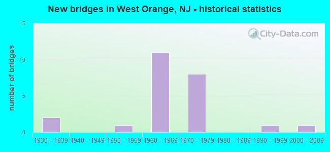
- New bridges - historical statistics
- 21930-1939
- 11950-1959
- 111960-1969
- 81970-1979
- 11990-1999
- 12000-2009
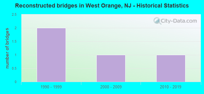
- Reconstructed bridges - Historical Statistics
- 21990-1999
- 12000-2009
- 12010-2019
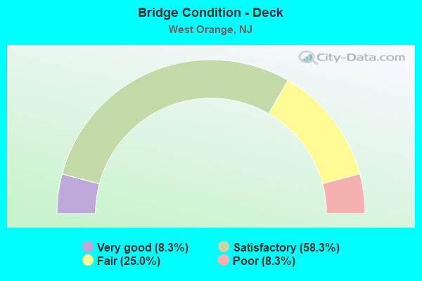
- Bridge Condition - Deck
- 8.3%Very good
- 58.3%Satisfactory
- 25.0%Fair
- 8.3%Poor
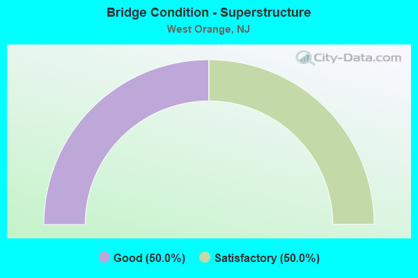
- Bridge Condition - Superstructure
- 50.0%Good
- 50.0%Satisfactory
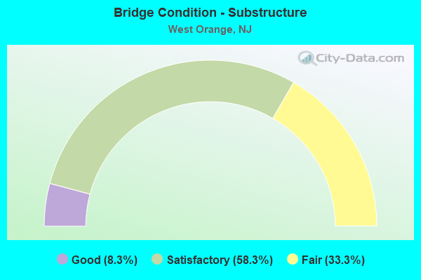
- Bridge Condition - Substructure
- 8.3%Good
- 58.3%Satisfactory
- 33.3%Fair
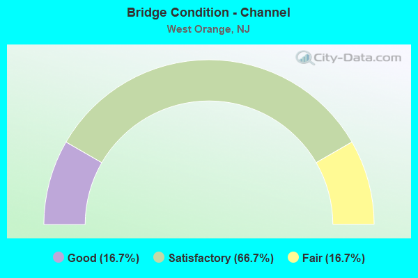
- Bridge Condition - Channel
- 16.7%Good
- 66.7%Satisfactory
- 16.7%Fair
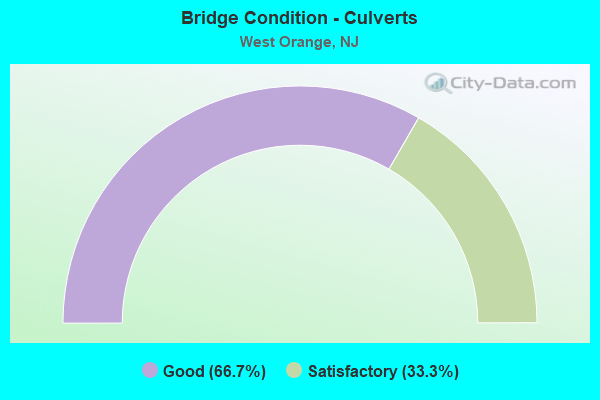
- Bridge Condition - Culverts
- 66.7%Good
- 33.3%Satisfactory
Find on map >> Show street view
Structure Number: 700009, Location: 0.15 miles east of CR 659 (Lat: 40.786189, Lng: -74.228369), Route carried "on" structure: County highway 671, Year Built: 1930, Status: Open, Structure Length: 0.70m (2.30ft), Average Daily Traffic: 5,161 (year 2021), Truck Traffic: 4%, Average Future Daily Traffic: 6,193 (year 2041), Features Intersected: Wigwam Brook, Facility Carried by Structure: Washington Street
Minimum Vertical Clearance: 30+ m (98+ ft), Kilometerpoint: 0.402, Lanes on structure: 2, Owner: County Highway Agency, Approaching Roadway Width: 12.2m (40.0ft), Skew: 2 degrees, Material/Design: Concrete, Design/Construction: Slab, Number Of Spans In Main Unit: 1, Length of Maximum Span: 6.4m (21.0ft), Curb or Sidewalk Widths: Left: 2.9m (9.5ft), Right: 3.0m (9.8ft), Curb-To-Curb Width: 12.2m (40.0ft), Out-to-Out Width: 34.4m (112.9ft)
Condition: Deck: Satisfactory, Superstructure: Satisfactory, Substructure: Satisfactory, Channel: Good, Operating Rating: 48.1 metric tons, Method Used To Determine Operating Rating: Load Factor (LF), Inventory Rating: 29.0 metric tons, Method Used To Determine Inventory Rating: Load Factor (LF), Structural Evaluation: Equal to present minimum criteria, Deck Geometry: Somewhat better than minimum adequacy, Waterway Adequacy: Better than present minimum criteria, Approach Roadway Alignment: Better than present minimum criteria, Designated Inspection Frequency: Every 24 months, Inspection Date: August 2021, Deck Structure Type: Concrete Cast-file-Place, Wearing Surface/Protective System: Wearing Surface: Bituminous
Find on map >> Show street view
Structure Number: 700028, Location: 0.18 M.E.OF PLEASANT VALY (Lat: 40.769419, Lng: -74.283400), Route carried "on" structure: County highway 508, Year Built: 1938, Year Reconstructed: 2000, Status: Open, Structure Length: 0.98m (3.22ft), Average Daily Traffic: 18,630 (year 2020), Truck Traffic: 4%, Average Future Daily Traffic: 22,728 (year 2040), Design Load: HS 20, Features Intersected: W.BR. RAHWAY RIVER
Minimum Vertical Clearance: 30+ m (98+ ft), Kilometerpoint: 6.502, Lanes on structure: 5, Base Highway Network: Yes, Owner: County Highway Agency, Approaching Roadway Width: 19.8m (65.0ft), Skew: 22 degrees, Material/Design: Prestressed concrete, Design/Construction: Slab, Number Of Spans In Main Unit: 1, Length of Maximum Span: 9.4m (30.8ft), Curb or Sidewalk Widths: Left: 4.3m (14.1ft), Right: 2.5m (8.2ft), Curb-To-Curb Width: 20.0m (65.6ft), Out-to-Out Width: 30.5m (100.1ft)
Condition: Deck: Satisfactory, Superstructure: Satisfactory, Substructure: Satisfactory, Channel: Satisfactory, Operating Rating: 53.5 metric tons, Method Used To Determine Operating Rating: Load Factor (LF), Inventory Rating: 31.8 metric tons, Method Used To Determine Inventory Rating: Load Factor (LF), Structural Evaluation: Equal to present minimum criteria, Deck Geometry: Somewhat better than minimum adequacy, Waterway Adequacy: Equal to present minimum criteria, Approach Roadway Alignment: Equal to present desirable criteria, Length Of Structure Improvement: 0.98m (3.22ft), Designated Inspection Frequency: Every 24 months, Inspection Date: September 2020, Deck Structure Type: Concrete Cast-file-Place, Wearing Surface/Protective System: Wearing Surface: Bituminous, Membrane: Other, Deck Protection: Epoxy Coated Reinforcing
Find on map >> Show street view
Structure Number: 700084, Location: 800FT NORTHWEST OF RT 10 (Lat: 40.793611, Lng: -74.267511), Route carried "on" structure: City street , Year Built: 2000, Status: Open, Structure Length: 0.61m (2.00ft), Average Daily Traffic: 801 (year 2021), Truck Traffic: 1%, Average Future Daily Traffic: 961 (year 2041), Design Load: HS 25 or greater, Features Intersected: W. Br. of Rahway River, Facility Carried by Structure: Mt. Pleasant Place
Minimum Vertical Clearance: 30+ m (98+ ft), Kilometerpoint: 0.000, Lanes on structure: 2, Owner: County Highway Agency, Approaching Roadway Width: 7.9m (25.9ft), Material/Design: Concrete, Design/Construction: Culvert, Number Of Spans In Main Unit: 1, Length of Maximum Span: 6.1m (20.0ft), Curb or Sidewalk Widths: Left: 1.8m (5.9ft), Right: 0.0m, Curb-To-Curb Width: 8.0m (26.2ft), Out-to-Out Width: 10.7m (35.1ft)
Condition: Channel: Satisfactory, Culverts: Good, Inventory Rating: 54.4 metric tons, Method Used To Determine Inventory Rating: Load Factor (LF), Structural Evaluation: Better than present minimum criteria, Deck Geometry: Somewhat better than minimum adequacy, Waterway Adequacy: Equal to present desirable criteria, Approach Roadway Alignment: Equal to present desirable criteria, Designated Inspection Frequency: Every 24 months, Inspection Date: August 2021, Deck Structure Type: Concrete Precast Panels, Wearing Surface/Protective System: Wearing Surface: Bituminous
Find on map >> Show street view
Structure Number: 700097, Location: 700FT EAST OF CTY RT 636 (Lat: 40.814461, Lng: -74.254119), Route carried "on" structure: City street , Year Built: 1956, Status: Open, Structure Length: 0.67m (2.20ft), Average Daily Traffic: 978 (year 2021), Truck Traffic: 3%, Average Future Daily Traffic: 1,174 (year 2041), Design Load: H 20, Features Intersected: Peckman River, Facility Carried by Structure: Woodland Avenue
Minimum Vertical Clearance: 30+ m (98+ ft), Kilometerpoint: 0.274, Lanes on structure: 2, Owner: County Highway Agency, Approaching Roadway Width: 10.4m (34.1ft), Skew: 2 degrees, Material/Design: Concrete, Design/Construction: Slab, Number Of Spans In Main Unit: 1, Length of Maximum Span: 6.4m (21.0ft), Curb or Sidewalk Widths: Left: 2.0m (6.6ft), Right: 2.0m (6.6ft), Curb-To-Curb Width: 10.4m (34.1ft), Out-to-Out Width: 15.2m (49.9ft)
Condition: Deck: Satisfactory, Superstructure: Satisfactory, Substructure: Satisfactory, Channel: Satisfactory, Operating Rating: 34.5 metric tons, Method Used To Determine Operating Rating: Load Factor (LF), Inventory Rating: 20.9 metric tons, Method Used To Determine Inventory Rating: Load Factor (LF), Structural Evaluation: Somewhat better than minimum adequacy, Deck Geometry: Equal to present minimum criteria, Waterway Adequacy: Better than present minimum criteria, Approach Roadway Alignment: Equal to present desirable criteria, Designated Inspection Frequency: Every 24 months, Inspection Date: August 2021, Deck Structure Type: Concrete Cast-file-Place, Wearing Surface/Protective System: Wearing Surface: Bituminous
Find on map >> Show street view
Structure Number: 703265, Location: 375 FT E PLEASANT VALY WY (Lat: 40.783850, Lng: -74.273789), Route carried "on" structure: City street , Year Built: 1998, Status: Open, Structure Length: 0.82m (2.69ft), Average Daily Traffic: 1,143 (year 2020), Truck Traffic: 3%, Average Future Daily Traffic: 1,395 (year 2040), Design Load: HS 25 or greater, Features Intersected: WEST BR RAHWAY RIVER, Facility Carried by Structure: OLD INDIAN ROAD
Minimum Vertical Clearance: 30+ m (98+ ft), Kilometerpoint: 0.113, Lanes on structure: 2, Owner: County Highway Agency, Approaching Roadway Width: 10.4m (34.1ft), Material/Design: Concrete, Design/Construction: Culvert, Number Of Spans In Main Unit: 1, Length of Maximum Span: 7.9m (25.9ft), Curb or Sidewalk Widths: Left: 0.0m, Right: 1.8m (5.9ft), Curb-To-Curb Width: 10.4m (34.1ft), Out-to-Out Width: 13.0m (42.7ft)
Condition: Channel: Satisfactory, Culverts: Satisfactory, Operating Rating: 82.6 metric tons, Method Used To Determine Operating Rating: Load Factor (LF), Inventory Rating: 49.0 metric tons, Method Used To Determine Inventory Rating: Load Factor (LF), Structural Evaluation: Equal to present minimum criteria, Deck Geometry: Equal to present minimum criteria, Waterway Adequacy: Better than present minimum criteria, Approach Roadway Alignment: Equal to present desirable criteria, Designated Inspection Frequency: Every 24 months, Inspection Date: September 2020, Deck Structure Type: Concrete Precast Panels, Wearing Surface/Protective System: Wearing Surface: Bituminous, Membrane: Preformed Fabric, Deck Protection: Epoxy Coated Reinforcing
Find on map >> Show street view
Structure Number: 71215, Location: .75MILE WEST OF CO RT 577 (Lat: 40.792561, Lng: -74.269131), Route carried "on" structure: State highway 10, Year Built: 1962, Status: Open, Structure Length: 0.73m (2.40ft), Average Daily Traffic: 8,770 (year 2020), Truck Traffic: 4%, Average Future Daily Traffic: 10,500 (year 2040), Features Intersected: WEST BR. RAHWAY RIVER
Minimum Vertical Clearance: 30+ m (98+ ft), Kilometerpoint: 36.596, Lanes on structure: 4, Base Highway Network: Yes, Owner: State Highway Agency, Approaching Roadway Width: 15.2m (49.9ft), Skew: 3 degrees, Material/Design: Concrete, Design/Construction: Culvert, Number Of Spans In Main Unit: 1, Length of Maximum Span: 7.3m (24.0ft), Curb or Sidewalk Widths: Left: 3.7m (12.1ft), Right: 2.8m (9.2ft), Curb-To-Curb Width: 15.5m (50.9ft), Out-to-Out Width: 22.6m (74.1ft)
Condition: Channel: Fair, Culverts: Good, Operating Rating: 60.8 metric tons, Method Used To Determine Operating Rating: Load Factor (LF), Inventory Rating: 36.3 metric tons, Method Used To Determine Inventory Rating: Load Factor (LF), Structural Evaluation: Better than present minimum criteria, Deck Geometry: Meets minimum limits, Waterway Adequacy: Equal to present minimum criteria, Approach Roadway Alignment: Equal to present minimum criteria, Designated Inspection Frequency: Every 24 months, Inspection Date: June 2020
Find on map >> Show street view
Structure Number: 729158, Location: AT CR 636 & I-280 JCT (Lat: 40.797739, Lng: -74.266981), Route carried "on" structure: Interstate 280, Year Built: 1966, Status: Open, Structure Length: 4.24m (13.91ft), Average Daily Traffic: 54,600 (year 2021), Truck Traffic: 9%, Average Future Daily Traffic: 65,500 (year 2041), Design Load: HS 20, Features Intersected: PLEASANT VALLEY WAY
Minimum Vertical Clearance: 30+ m (98+ ft), Kilometerpoint: 12.054, Lanes on structure: 3, Lanes under structure: 4, Base Highway Network: Yes, Owner: State Highway Agency, Approaching Roadway Width: 15.5m (50.9ft), Skew: 2 degrees, Material/Design: Steel, Design/Construction: Stringer/Multi-beam, Number Of Spans In Main Unit: 2, Length of Maximum Span: 22.3m (73.2ft), Curb or Sidewalk Widths: Left: 0.5m (1.6ft), Right: 0.5m (1.6ft), Curb-To-Curb Width: 15.5m (50.9ft), Out-to-Out Width: 17.1m (56.1ft)
Condition: Deck: Satisfactory, Superstructure: Good, Substructure: Satisfactory, Operating Rating: 71.7 metric tons, Method Used To Determine Operating Rating: Load Factor (LF), Inventory Rating: 42.6 metric tons, Method Used To Determine Inventory Rating: Load Factor (LF), Structural Evaluation: Equal to present minimum criteria, Deck Geometry: Somewhat better than minimum adequacy, Underclear: Meets minimum limits, Approach Roadway Alignment: Equal to present desirable criteria, Designated Inspection Frequency: Every 24 months, Inspection Date: March 2021, Deck Structure Type: Concrete Cast-file-Place, Wearing Surface/Protective System: Wearing Surface: Bituminous
Find on map >> Show street view
Structure Number: 729159, Location: AT I-280 - CR 636 JCT (Lat: 40.797961, Lng: -74.266811), Route carried "on" structure: Interstate 280, Year Built: 1966, Status: Open, Structure Length: 4.24m (13.91ft), Average Daily Traffic: 54,600 (year 2021), Truck Traffic: 9%, Average Future Daily Traffic: 65,500 (year 2041), Design Load: HS 20, Features Intersected: PLEASANT VALLEY WAY
Minimum Vertical Clearance: 30+ m (98+ ft), Kilometerpoint: 12.054, Lanes on structure: 4, Lanes under structure: 4, Base Highway Network: Yes, Owner: State Highway Agency, Approaching Roadway Width: 17.1m (56.1ft), Skew: 2 degrees, Material/Design: Steel, Design/Construction: Stringer/Multi-beam, Number Of Spans In Main Unit: 2, Length of Maximum Span: 22.6m (74.1ft), Curb or Sidewalk Widths: Left: 0.5m (1.6ft), Right: 0.5m (1.6ft), Curb-To-Curb Width: 16.8m (55.1ft), Out-to-Out Width: 18.3m (60.0ft)
Condition: Deck: Satisfactory, Superstructure: Good, Substructure: Satisfactory, Operating Rating: 71.7 metric tons, Method Used To Determine Operating Rating: Load Factor (LF), Inventory Rating: 42.6 metric tons, Method Used To Determine Inventory Rating: Load Factor (LF), Structural Evaluation: Equal to present minimum criteria, Deck Geometry: High priority of replacement, Underclear: Meets minimum limits, Approach Roadway Alignment: Equal to present desirable criteria, Length Of Structure Improvement: 4.24m (13.91ft), Designated Inspection Frequency: Every 24 months, Inspection Date: March 2021, Bridge Improvement Cost: $42,000, Roadway Improvement Cost: $50,000, Total Project Cost: $146,000 ( Estimate for 2021), Deck Structure Type: Concrete Cast-file-Place, Wearing Surface/Protective System: Wearing Surface: Bituminous
Find on map >> Show street view
Structure Number: 73015, Location: AT I-280-CR 577 JCT (Lat: 40.797381, Lng: -74.252739), Route carried "on" structure: County highway 577, Year Built: 1965, Year Reconstructed: 1996, Status: Open, Structure Length: 6.00m (19.69ft), Average Daily Traffic: 11,730 (year 2021), Truck Traffic: 4%, Average Future Daily Traffic: 14,100 (year 2041), Design Load: HS 20, Features Intersected: I-280
Minimum Vertical Clearance: 30+ m (98+ ft), Kilometerpoint: 17.365, Lanes on structure: 3, Lanes under structure: 10, Base Highway Network: Yes, Owner: State Highway Agency, Approaching Roadway Width: 11.6m (38.1ft), Material/Design: Steel, Design/Construction: Stringer/Multi-beam, Number Of Spans In Main Unit: 2, Length of Maximum Span: 29.0m (95.1ft), Curb or Sidewalk Widths: Left: 1.8m (5.9ft), Right: 0.8m (2.6ft), Curb-To-Curb Width: 11.6m (38.1ft), Out-to-Out Width: 14.8m (48.6ft)
Condition: Deck: Fair, Superstructure: Satisfactory, Substructure: Satisfactory, Operating Rating: 81.6 metric tons, Method Used To Determine Operating Rating: Load Factor (LF), Inventory Rating: 49.0 metric tons, Method Used To Determine Inventory Rating: Load Factor (LF), Structural Evaluation: Equal to present minimum criteria, Deck Geometry: High priority of replacement, Underclear: High priority of corrective action, Approach Roadway Alignment: Better than present minimum criteria, Length Of Structure Improvement: 6.00m (19.69ft), Designated Inspection Frequency: Every 24 months, Inspection Date: March 2021, Bridge Improvement Cost: $1,484,000, Roadway Improvement Cost: $250,000, Total Project Cost: $2,110,000 ( Estimate for 2021), Deck Structure Type: Concrete Cast-file-Place, Wearing Surface/Protective System: Wearing Surface: Latex Concrete
Find on map >> Show street view
Structure Number: 730151, Location: AT I-280-CR 577 JCT (Lat: 40.797250, Lng: -74.252269), Route carried "on" structure: County highway 577, Year Built: 1966, Year Reconstructed: 1996, Status: Open, Structure Length: 6.00m (19.69ft), Average Daily Traffic: 11,730 (year 2021), Truck Traffic: 4%, Average Future Daily Traffic: 14,100 (year 2041), Design Load: HS 20, Features Intersected: I-280
Minimum Vertical Clearance: 30+ m (98+ ft), Kilometerpoint: 17.365, Lanes on structure: 3, Lanes under structure: 10, Base Highway Network: Yes, Owner: State Highway Agency, Approaching Roadway Width: 11.6m (38.1ft), Skew: 1 degrees, Material/Design: Steel, Design/Construction: Stringer/Multi-beam, Number Of Spans In Main Unit: 2, Length of Maximum Span: 29.0m (95.1ft), Curb or Sidewalk Widths: Left: 0.8m (2.6ft), Right: 1.8m (5.9ft), Curb-To-Curb Width: 11.6m (38.1ft), Out-to-Out Width: 14.8m (48.6ft)
Condition: Deck: Satisfactory, Superstructure: Satisfactory, Substructure: Satisfactory, Operating Rating: 79.8 metric tons, Method Used To Determine Operating Rating: Load Factor (LF), Inventory Rating: 48.1 metric tons, Method Used To Determine Inventory Rating: Load Factor (LF), Structural Evaluation: Equal to present minimum criteria, Deck Geometry: High priority of replacement, Underclear: High priority of corrective action, Approach Roadway Alignment: Equal to present desirable criteria, Length Of Structure Improvement: 6.00m (19.69ft), Designated Inspection Frequency: Every 24 months, Inspection Date: March 2021, Bridge Improvement Cost: $1,319,000, Roadway Improvement Cost: $250,000, Total Project Cost: $1,919,000 ( Estimate for 2021), Deck Structure Type: Concrete Cast-file-Place, Wearing Surface/Protective System: Wearing Surface: Latex Concrete
Find on map >> Show street view
Structure Number: 730152, Location: I-280 AT EXIT 8 (Lat: 40.796200, Lng: -74.252731), Route carried "on" structure: Ramp Interstate 280, Year Built: 1966, Year Reconstructed: 2016, Status: Open, Structure Length: 2.53m (8.30ft), Average Daily Traffic: 5,310 (year 2021), Truck Traffic: 9%, Average Future Daily Traffic: 6,370 (year 2041), Design Load: HL 93, Features Intersected: PROSPECT AVE (CR 577) NB
Minimum Vertical Clearance: 30+ m (98+ ft), Kilometerpoint: 13.293, Lanes on structure: 1, Lanes under structure: 2, Owner: State Highway Agency, Approaching Roadway Width: 6.7m (22.0ft), Skew: 9 degrees, Material/Design: Steel, Design/Construction: Stringer/Multi-beam, Number Of Spans In Main Unit: 1, Length of Maximum Span: 23.8m (78.1ft), Curb-To-Curb Width: 7.6m (24.9ft), Out-to-Out Width: 8.5m (27.9ft)
Condition: Deck: Very good, Superstructure: Good, Substructure: Good, Operating Rating: 76.8 metric tons, Method Used To Determine Operating Rating: Load and Resistance Factor Rating (LRFR) rating reported by rating factor(RF) method using HL-93 loadings, Inventory Rating: 62.5 metric tons, Method Used To Determine Inventory Rating: Load and Resistance Factor Rating (LRFR) rating reported by rating factor(RF) method using HL-93 loadings, Structural Evaluation: Better than present minimum criteria, Deck Geometry: Better than present minimum criteria, Underclear: Meets minimum limits, Approach Roadway Alignment: Equal to present minimum criteria, Designated Inspection Frequency: Every 24 months, Inspection Date: March 2021, Bridge Improvement Cost: $413,000, Roadway Improvement Cost: $50,000, Total Project Cost: $533,000 ( Estimate for 2015), Deck Structure Type: Concrete Cast-file-Place, Wearing Surface/Protective System: Deck Protection: Epoxy Coated Reinforcing
Find on map >> Show street view
Structure Number: 730153, Location: 2.4 MI W OF 280-GSP JCT (Lat: 40.779811, Lng: -74.241931), Route carried "on" structure: County highway 660, Year Built: 1971, Status: Open, Structure Length: 7.35m (24.11ft), Average Daily Traffic: 8,600 (year 2021), Truck Traffic: 4%, Average Future Daily Traffic: 10,320 (year 2041), Design Load: HS 20+Mod, Features Intersected: ROUTE I-280, Facility Carried by Structure: MT. PLEASANT AVE
Minimum Vertical Clearance: 30+ m (98+ ft), Kilometerpoint: 0.724, Lanes on structure: 4, Lanes under structure: 7, Base Highway Network: Yes, Owner: State Highway Agency, Approaching Roadway Width: 14.0m (45.9ft), Skew: 4 degrees, Material/Design: Steel continuous, Design/Construction: Stringer/Multi-beam, Number Of Spans In Main Unit: 2, Number Of Approach Spans: 2, Length of Maximum Span: 29.9m (98.1ft), Curb or Sidewalk Widths: Left: 1.8m (5.9ft), Right: 2.4m (7.9ft), Curb-To-Curb Width: 14.0m (45.9ft), Out-to-Out Width: 18.9m (62.0ft)
Condition: Deck: Fair, Superstructure: Good, Substructure: Fair, Operating Rating: 80.7 metric tons, Method Used To Determine Operating Rating: Load Factor (LF), Inventory Rating: 48.1 metric tons, Method Used To Determine Inventory Rating: Load Factor (LF), Structural Evaluation: Somewhat better than minimum adequacy, Deck Geometry: High priority of replacement, Underclear: Meets minimum limits, Approach Roadway Alignment: Equal to present desirable criteria, Length Of Structure Improvement: 7.35m (24.11ft), Designated Inspection Frequency: Every 24 months, Inspection Date: March 2021, Bridge Improvement Cost: $145,000, Roadway Improvement Cost: $50,000, Total Project Cost: $270,000 ( Estimate for 2021), Deck Structure Type: Concrete Cast-file-Place, Wearing Surface/Protective System: Wearing Surface: Bituminous
Find on map >> Show street view
Structure Number: 730154, Location: 2.2 MI W OF I-280-GSP JCT (Lat: 40.776081, Lng: -74.241981), Route carried "on" structure: Spur County highway 508, Year Built: 1971, Status: Open, Structure Length: 5.52m (18.11ft), Average Daily Traffic: 17,641 (year 2021), Truck Traffic: 4%, Average Future Daily Traffic: 21,169 (year 2041), Design Load: HS 20, Features Intersected: I-280, Facility Carried by Structure: NORTHFIELD AVE
Minimum Vertical Clearance: 30+ m (98+ ft), Kilometerpoint: 0.295, Lanes on structure: 4, Lanes under structure: 7, Base Highway Network: Yes, Owner: State Highway Agency, Approaching Roadway Width: 14.0m (45.9ft), Material/Design: Steel, Design/Construction: Stringer/Multi-beam, Number Of Spans In Main Unit: 2, Length of Maximum Span: 31.1m (102.0ft), Curb or Sidewalk Widths: Left: 2.4m (7.9ft), Right: 2.4m (7.9ft), Curb-To-Curb Width: 14.0m (45.9ft), Out-to-Out Width: 19.5m (64.0ft)
Condition: Deck: Fair, Superstructure: Good, Substructure: Fair, Operating Rating: 37.2 metric tons, Method Used To Determine Operating Rating: Load Factor (LF), Inventory Rating: 21.8 metric tons, Method Used To Determine Inventory Rating: Load Factor (LF), Structural Evaluation: Somewhat better than minimum adequacy, Deck Geometry: High priority of replacement, Underclear: High priority of corrective action, Approach Roadway Alignment: Equal to present desirable criteria, Length Of Structure Improvement: 5.52m (18.11ft), Designated Inspection Frequency: Every 24 months, Inspection Date: July 2021, Bridge Improvement Cost: $1,808,000, Roadway Improvement Cost: $125,000, Total Project Cost: $2,934,000 ( Estimate for 2021), Deck Structure Type: Concrete Cast-file-Place, Wearing Surface/Protective System: Wearing Surface: Monolithic Concrete
Find on map >> Show street view
Structure Number: 730155, Location: 2.1 MI WEST OF GSP JCT (Lat: 40.774019, Lng: -74.240800), Route carried "on" structure: City street , Year Built: 1971, Status: Open, Structure Length: 8.35m (27.40ft), Average Daily Traffic: 2,360 (year 2021), Truck Traffic: 3%, Average Future Daily Traffic: 2,840 (year 2041), Design Load: HS 20+Mod, Features Intersected: I-280, Facility Carried by Structure: WHITTINGHAM PLACE
Minimum Vertical Clearance: 30+ m (98+ ft), Kilometerpoint: 0.080, Lanes on structure: 2, Lanes under structure: 8, Owner: State Highway Agency, Approaching Roadway Width: 9.1m (29.9ft), Skew: 4 degrees, Material/Design: Steel, Design/Construction: Stringer/Multi-beam, Number Of Spans In Main Unit: 4, Length of Maximum Span: 29.6m (97.1ft), Curb or Sidewalk Widths: Left: 1.9m (6.2ft), Right: 1.9m (6.2ft), Curb-To-Curb Width: 9.1m (29.9ft), Out-to-Out Width: 14.6m (47.9ft)
Condition: Deck: Satisfactory, Superstructure: Satisfactory, Substructure: Fair, Operating Rating: 72.6 metric tons, Method Used To Determine Operating Rating: Load Factor (LF), Inventory Rating: 43.5 metric tons, Method Used To Determine Inventory Rating: Load Factor (LF), Structural Evaluation: Somewhat better than minimum adequacy, Deck Geometry: Meets minimum limits, Underclear: High priority of corrective action, Approach Roadway Alignment: Equal to present desirable criteria, Length Of Structure Improvement: 8.35m (27.40ft), Designated Inspection Frequency: Every 24 months, Inspection Date: March 2021, Roadway Improvement Cost: $1,500,000, Total Project Cost: $1,725,000 ( Estimate for 2021), Deck Structure Type: Concrete Cast-file-Place
Find on map >> Show street view
Structure Number: 730156, Location: 0.23 MI E OF I280 EXIT 10 (Lat: 40.772911, Lng: -74.240850), Route carried "on" structure: City street , Year Built: 1971, Status: Open, Structure Length: 8.14m (26.71ft), Average Daily Traffic: 14,995 (year 2020), Truck Traffic: 4%, Average Future Daily Traffic: 18,297 (year 2040), Design Load: HS 20, Features Intersected: ROUTE I-280, Facility Carried by Structure: VALLEY RD
Minimum Vertical Clearance: 30+ m (98+ ft), Kilometerpoint: 6.132, Lanes on structure: 2, Lanes under structure: 9, Base Highway Network: Yes, Owner: State Highway Agency, Approaching Roadway Width: 9.1m (29.9ft), Skew: 3 degrees, Material/Design: Steel, Design/Construction: Stringer/Multi-beam, Number Of Spans In Main Unit: 4, Length of Maximum Span: 31.4m (103.0ft), Curb or Sidewalk Widths: Left: 2.4m (7.9ft), Right: 2.4m (7.9ft), Curb-To-Curb Width: 9.1m (29.9ft), Out-to-Out Width: 14.6m (47.9ft)
Condition: Deck: Poor, Superstructure: Good, Substructure: Fair, Operating Rating: 40.8 metric tons, Method Used To Determine Operating Rating: Load Factor (LF), Inventory Rating: 24.5 metric tons, Method Used To Determine Inventory Rating: Load Factor (LF), Structural Evaluation: Somewhat better than minimum adequacy, Deck Geometry: Meets minimum limits, Underclear: High priority of corrective action, Approach Roadway Alignment: Equal to present desirable criteria, Length Of Structure Improvement: 8.14m (26.71ft), Designated Inspection Frequency: Every 24 months, Inspection Date: June 2020, Bridge Improvement Cost: $2,527,000, Roadway Improvement Cost: $50,000, Total Project Cost: $2,785,000 ( Estimate for 2020), Deck Structure Type: Concrete Cast-file-Place, Wearing Surface/Protective System: Wearing Surface: Monolithic Concrete
Find on map >> Show street view
Structure Number: 729158, Location: AT CR 636 & I-280 JCT (Lat: 40.797739, Lng: -74.266981), Route carried "under" structure: County highway 636, Year Built: 1966, Structure Length: 0. m, Average Daily Traffic: 23,200 (year 2021), Truck Traffic: 4%, Features Intersected: PLEASANT VALLEY WAY, Facility Carried by Structure: I-280 EASTBOUND.
Minimum Vertical Clearance: 7.01m (23.00ft), Kilometerpoint: 3.637, Lanes on structure: 3, Lanes under structure: 4, Material/Design: Steel, Design/Construction: Stringer/Multi-beam, Length of Maximum Span: 22.3m (73.2ft)
Find on map >> Show street view
Structure Number: 729159, Location: AT I-280 - CR 636 JCT (Lat: 40.797961, Lng: -74.266811), Route carried "under" structure: County highway 636, Year Built: 1966, Structure Length: 0. m, Average Daily Traffic: 23,200 (year 2021), Truck Traffic: 9%, Features Intersected: PLEASANT VALLEY WAY, Facility Carried by Structure: I-280 WB
Minimum Vertical Clearance: 5.08m (16.67ft), Kilometerpoint: 3.637, Lanes on structure: 4, Lanes under structure: 4, Material/Design: Steel, Design/Construction: Stringer/Multi-beam, Length of Maximum Span: 22.6m (74.1ft)
Find on map >> Show street view
Structure Number: 73015, Location: AT I-280-CR 577 JCT (Lat: 40.797381, Lng: -74.252739), Route carried "under" structure: Interstate 280, Year Built: 1965, Structure Length: 0. m, Average Daily Traffic: 102,800 (year 2021), Truck Traffic: 9%, Features Intersected: I-280, Facility Carried by Structure: PROS.AVE(CR577) SB
Minimum Vertical Clearance: 6.40m (21.00ft), Kilometerpoint: 13.293, Lanes on structure: 3, Lanes under structure: 10, Material/Design: Steel, Design/Construction: Stringer/Multi-beam, Length of Maximum Span: 29.0m (95.1ft)
Find on map >> Show street view
Structure Number: 730151, Location: AT I-280-CR 577 JCT (Lat: 40.797250, Lng: -74.252269), Route carried "under" structure: Interstate 280, Year Built: 1966, Structure Length: 0. m, Average Daily Traffic: 102,800 (year 2021), Truck Traffic: 9%, Features Intersected: I-280, Facility Carried by Structure: PROSP AVE(CR577)NB
Minimum Vertical Clearance: 4.60m (15.09ft), Kilometerpoint: 13.293, Lanes on structure: 3, Lanes under structure: 10, Material/Design: Steel, Design/Construction: Stringer/Multi-beam, Length of Maximum Span: 29.0m (95.1ft)
Find on map >> Show street view
Structure Number: 730152, Location: I-280 AT EXIT 8 (Lat: 40.796200, Lng: -74.252731), Route carried "under" structure: County highway 577, Year Built: 1966, Structure Length: 0. m, Average Daily Traffic: 11,730 (year 2021), Truck Traffic: 4%, Features Intersected: PROSPECT AVE (CR 577) NB, Facility Carried by Structure: I-280 RAMP 2P
Minimum Vertical Clearance: 4.48m (14.70ft), Kilometerpoint: 17.204, Lanes on structure: 1, Lanes under structure: 2, Material/Design: Steel, Design/Construction: Stringer/Multi-beam, Length of Maximum Span: 23.8m (78.1ft)
Find on map >> Show street view
Structure Number: 730153, Location: 2.4 MI W OF 280-GSP JCT (Lat: 40.779811, Lng: -74.241931), Route carried "under" structure: Interstate 280, Year Built: 1971, Structure Length: 0. m, Average Daily Traffic: 95,800 (year 2021), Truck Traffic: 9%, Features Intersected: ROUTE I-280, Facility Carried by Structure: MT. PLEASANT AVE
Minimum Vertical Clearance: 6.86m (22.51ft), Kilometerpoint: 15.514, Lanes on structure: 4, Lanes under structure: 7, Material/Design: Steel continuous, Design/Construction: Stringer/Multi-beam, Length of Maximum Span: 29.9m (98.1ft)
Find on map >> Show street view
Structure Number: 730154, Location: 2.2 MI W OF I-280-GSP JCT (Lat: 40.776081, Lng: -74.241981), Route carried "under" structure: Interstate 280, Year Built: 1971, Structure Length: 0. m, Average Daily Traffic: 107,406 (year 2021), Truck Traffic: 9%, Features Intersected: I-280, Facility Carried by Structure: NORTHFIELD AVE
Minimum Vertical Clearance: 5.54m (18.18ft), Kilometerpoint: 15.949, Lanes on structure: 4, Lanes under structure: 7, Material/Design: Steel, Design/Construction: Stringer/Multi-beam, Length of Maximum Span: 31.1m (102.0ft)
Find on map >> Show street view
Structure Number: 730155, Location: 2.1 MI WEST OF GSP JCT (Lat: 40.774019, Lng: -74.240800), Route carried "under" structure: Interstate 280, Year Built: 1971, Structure Length: 0. m, Average Daily Traffic: 127,500 (year 2021), Truck Traffic: 9%, Features Intersected: I-280, Facility Carried by Structure: WHITTINGHAM PLACE
Minimum Vertical Clearance: 5.66m (18.57ft), Kilometerpoint: 16.174, Lanes on structure: 2, Lanes under structure: 8, Material/Design: Steel, Design/Construction: Stringer/Multi-beam, Length of Maximum Span: 29.6m (97.1ft)
Find on map >> Show street view
Structure Number: 730156, Location: 0.23 MI E OF I280 EXIT 10 (Lat: 40.772911, Lng: -74.240850), Route carried "under" structure: Interstate 280, Year Built: 1971, Structure Length: 0. m, Average Daily Traffic: 102,163 (year 2020), Truck Traffic: 9%, Features Intersected: ROUTE I-280, Facility Carried by Structure: VALLEY RD
Minimum Vertical Clearance: 6.27m (20.57ft), Kilometerpoint: 16.303, Lanes on structure: 2, Lanes under structure: 9, Material/Design: Steel, Design/Construction: Stringer/Multi-beam, Length of Maximum Span: 31.4m (103.0ft)