Bridge Statistics for West Point, Alabama (AL)
Condition, Traffic, Stress, Structural Evaluation, Project Costs
- National Bridge Inventory (NBI) Statistics
- 15Number of bridges
- 197ft / 60.2mTotal length
- $25,494,000Total costs
- 36,528Total average daily traffic
- 4,003Total average daily truck traffic
- 54,065Total future (year 2031) average daily traffic
- National Bridge Inventory (NBI) Registered Bridges for West Point
- No street view available for this location
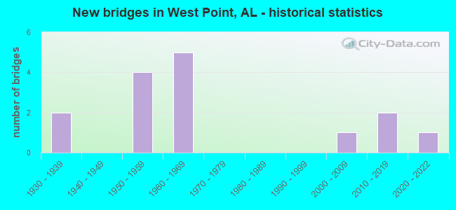
- New bridges - historical statistics
- 21930-1939
- 41950-1959
- 51960-1969
- 12000-2009
- 22010-2019
- 12020-2022


- Bridge Condition - Deck
- 20.0%Excellent
- 10.0%Very good
- 20.0%Good
- 30.0%Satisfactory
- 20.0%Fair

- Bridge Condition - Superstructure
- 10.0%Excellent
- 20.0%Very good
- 20.0%Good
- 50.0%Satisfactory

- Bridge Condition - Substructure
- 10.0%Excellent
- 10.0%Very good
- 20.0%Good
- 40.0%Satisfactory
- 20.0%Fair

- Bridge Condition - Channel
- 13.3%Very good
- 26.7%Good
- 46.7%Satisfactory
- 13.3%Fair

- Bridge Condition - Culverts
- 20.0%Good
- 80.0%Satisfactory
Find on map >> Show street view
Structure Number: 1127, Location: CR 1147 * US278 (Lat: 34.194111, Lng: -86.929750), Route carried "on" structure: County highway 1127, Year Built: 1934, Status: Open, Structure Length: 4.94m (16.21ft), Average Daily Traffic: 7,196 (year 2011), Truck Traffic: 11%, Average Future Daily Traffic: 13,000 (year 2031), Design Load: H 15, Features Intersected: KUGLAR CREEK, Facility Carried by Structure: CR 1147
Minimum Vertical Clearance: 30+ m (98+ ft), Kilometerpoint: 1.609, Lanes on structure: 2, Owner: County Highway Agency, Approaching Roadway Width: 9.1m (29.9ft), Material/Design: Steel continuous, Design/Construction: Stringer/Multi-beam, Number Of Spans In Main Unit: 3, Length of Maximum Span: 18.3m (60.0ft), Curb or Sidewalk Widths: Left: 0.1m (0.3ft), Right: 0.1m (0.3ft), Curb-To-Curb Width: 7.3m (24.0ft), Out-to-Out Width: 8.3m (27.2ft)
Condition: Deck: Satisfactory, Superstructure: Satisfactory, Substructure: Fair, Channel: Good, Operating Rating: 64.0 metric tons, Method Used To Determine Operating Rating: Load Factor (LF), Inventory Rating: 38.3 metric tons, Method Used To Determine Inventory Rating: Load Factor (LF), Structural Evaluation: Somewhat better than minimum adequacy, Deck Geometry: High priority of replacement, Waterway Adequacy: Meets minimum limits, Approach Roadway Alignment: Equal to present minimum criteria, Length Of Structure Improvement: 5.96m (19.55ft), Designated Inspection Frequency: Every 24 months, Inspection Date: March 2021, Bridge Improvement Cost: $1,103,000, Roadway Improvement Cost: $110,000, Total Project Cost: $1,213,000 ( Estimate for 2022), Deck Structure Type: Concrete Cast-file-Place
Find on map >> Show street view
Structure Number: 4781, Location: CR 1114 (Lat: 34.249231, Lng: -86.998186), Route carried "on" structure: County highway 7, Year Built: 1954, Status: Open, Structure Length: 0.69m (2.26ft), Average Daily Traffic: 400 (year 1991), Truck Traffic: 15%, Average Future Daily Traffic: 600 (year 2036), Design Load: H 15, Features Intersected: JAY BIRD CREEK, Facility Carried by Structure: CO. RD. 1114
Minimum Vertical Clearance: 30+ m (98+ ft), Kilometerpoint: 0.010, Lanes on structure: 2, Owner: County Highway Agency, Approaching Roadway Width: 6.7m (22.0ft), Material/Design: Concrete, Design/Construction: Culvert, Number Of Spans In Main Unit: 2, Length of Maximum Span: 3.0m (9.8ft)
Condition: Channel: Satisfactory, Culverts: Satisfactory, Operating Rating: 41.4 metric tons, Method Used To Determine Operating Rating: Load Factor (LF), Inventory Rating: 24.9 metric tons, Method Used To Determine Inventory Rating: Load Factor (LF), Structural Evaluation: Equal to present minimum criteria, Waterway Adequacy: Better than present minimum criteria, Approach Roadway Alignment: Better than present minimum criteria, Length Of Structure Improvement: 1.32m (4.33ft), Designated Inspection Frequency: Every 24 months, Inspection Date: September 2020, Bridge Improvement Cost: $243,000, Roadway Improvement Cost: $24,000, Total Project Cost: $267,000 ( Estimate for 2022), Wearing Surface/Protective System: Wearing Surface: Bituminous
Find on map >> Show street view
Structure Number: 6395, Location: 5.5 MI N JCT I-65 (Lat: 34.246667, Lng: -86.965000), Route carried "on" structure: State highway 157, Year Built: 1958, Status: Open, Structure Length: 0.76m (2.49ft), Average Daily Traffic: 9,840 (year 2020), Truck Traffic: 14%, Average Future Daily Traffic: 13,776 (year 2040), Design Load: H 20, Features Intersected: CROOKED CREEK
Minimum Vertical Clearance: 30+ m (98+ ft), Kilometerpoint: 19.714, Lanes on structure: 4, Owner: State Highway Agency, Approaching Roadway Width: 14.6m (47.9ft), Material/Design: Concrete, Design/Construction: Culvert, Number Of Spans In Main Unit: 2, Length of Maximum Span: 4.0m (13.1ft)
Condition: Channel: Satisfactory, Culverts: Satisfactory, Operating Rating: 88.9 metric tons, Method Used To Determine Operating Rating: Load Factor (LF), Inventory Rating: 88.9 metric tons, Method Used To Determine Inventory Rating: Load Factor (LF), Structural Evaluation: Equal to present minimum criteria, Waterway Adequacy: Equal to present desirable criteria, Approach Roadway Alignment: Better than present minimum criteria, Length Of Structure Improvement: 1.41m (4.63ft), Designated Inspection Frequency: Every 24 months, Inspection Date: October 2021, Bridge Improvement Cost: $2,577,000, Roadway Improvement Cost: $258,000, Total Project Cost: $2,835,000 ( Estimate for 2022), Wearing Surface/Protective System: Wearing Surface: Bituminous
Find on map >> Show street view
Structure Number: 6396, Location: 6.5 MI N JCT I 65 (Lat: 34.256667, Lng: -86.980000), Route carried "on" structure: State highway 157, Year Built: 1958, Status: Open, Structure Length: 1.10m (3.61ft), Average Daily Traffic: 9,840 (year 2020), Truck Traffic: 14%, Average Future Daily Traffic: 13,776 (year 2040), Design Load: H 20, Features Intersected: BRANCH
Minimum Vertical Clearance: 30+ m (98+ ft), Kilometerpoint: 21.300, Lanes on structure: 4, Owner: State Highway Agency, Approaching Roadway Width: 20.7m (67.9ft), Skew: 14 degrees, Material/Design: Concrete, Design/Construction: Culvert, Number Of Spans In Main Unit: 2, Length of Maximum Span: 5.5m (18.0ft)
Condition: Channel: Satisfactory, Culverts: Satisfactory, Operating Rating: 88.9 metric tons, Method Used To Determine Operating Rating: Load Factor (LF), Inventory Rating: 88.9 metric tons, Method Used To Determine Inventory Rating: Load Factor (LF), Structural Evaluation: Equal to present minimum criteria, Waterway Adequacy: Equal to present minimum criteria, Approach Roadway Alignment: Better than present minimum criteria, Length Of Structure Improvement: 1.77m (5.81ft), Designated Inspection Frequency: Every 24 months, Inspection Date: October 2021, Bridge Improvement Cost: $3,761,000, Roadway Improvement Cost: $376,000, Total Project Cost: $4,137,000 ( Estimate for 2022), Wearing Surface/Protective System: Wearing Surface: Bituminous
Find on map >> Show street view
Structure Number: 7657, Location: CR 1043 clarkson (Lat: 34.207533, Lng: -86.991239), Route carried "on" structure: County highway 14, Year Built: 1962, Status: Posted for load, Structure Length: 8.05m (26.41ft), Average Daily Traffic: 448 (year 2017), Truck Traffic: 9%, Average Future Daily Traffic: 560 (year 2037), Design Load: H 15, Features Intersected: CROOKED CREEK, Facility Carried by Structure: COUNTY ROAD 1043
Minimum Vertical Clearance: 30+ m (98+ ft), Kilometerpoint: 0.010, Lanes on structure: 2, Owner: County Highway Agency, Approaching Roadway Width: 9.1m (29.9ft), Material/Design: Concrete continuous, Design/Construction: Tee Beam, Number Of Spans In Main Unit: 3, Number Of Approach Spans: 3, Length of Maximum Span: 18.3m (60.0ft), Curb-To-Curb Width: 6.7m (22.0ft), Out-to-Out Width: 7.3m (24.0ft)
Condition: Deck: Satisfactory, Superstructure: Satisfactory, Substructure: Satisfactory, Channel: Satisfactory, Operating Rating: 31.2 metric tons, Method Used To Determine Operating Rating: Load Factor (LF), Inventory Rating: 18.0 metric tons, Method Used To Determine Inventory Rating: Load Factor (LF), Structural Evaluation: Somewhat better than minimum adequacy, Deck Geometry: Meets minimum limits, Waterway Adequacy: Better than present minimum criteria, Approach Roadway Alignment: Better than present minimum criteria, Bridge Posting: Required (Relationship of Operating Rating to Maximum Legal Load: 10.0 - 19.9% below), Length Of Structure Improvement: 9.06m (29.72ft), Designated Inspection Frequency: Every 24 months, Other Special Inspection Frequency: Every 12 months, Inspection Date: March 2021, Other Special Inspection Date: March 2022, Bridge Improvement Cost: $1,490,000, Roadway Improvement Cost: $149,000, Total Project Cost: $1,639,000 ( Estimate for 2022), Deck Structure Type: Concrete Cast-file-Place
Find on map >> Show street view
Structure Number: 8267, Location: CR 1141 (Lat: 34.239247, Lng: -86.973381), Route carried "on" structure: County highway 11, Year Built: 1964, Status: Open, Structure Length: 1.16m (3.81ft), Average Daily Traffic: 140 (year 1991), Truck Traffic: 10%, Average Future Daily Traffic: 200 (year 2036), Design Load: H 15, Features Intersected: CROOKED CREEK
Minimum Vertical Clearance: 30+ m (98+ ft), Kilometerpoint: 0.010, Lanes on structure: 2, Owner: County Highway Agency, Approaching Roadway Width: 7.3m (24.0ft), Material/Design: Concrete, Design/Construction: Culvert, Number Of Spans In Main Unit: 3, Length of Maximum Span: 3.7m (12.1ft)
Condition: Channel: Fair, Culverts: Satisfactory, Operating Rating: 88.9 metric tons, Method Used To Determine Operating Rating: Load Factor (LF), Inventory Rating: 88.9 metric tons, Method Used To Determine Inventory Rating: Load Factor (LF), Structural Evaluation: Equal to present minimum criteria, Waterway Adequacy: Better than present minimum criteria, Approach Roadway Alignment: Equal to present minimum criteria, Length Of Structure Improvement: 1.83m (6.00ft), Designated Inspection Frequency: Every 24 months, Inspection Date: September 2020, Bridge Improvement Cost: $518,000, Roadway Improvement Cost: $52,000, Total Project Cost: $570,000 ( Estimate for 2022), Wearing Surface/Protective System: Wearing Surface: Bituminous
Find on map >> Show street view
Structure Number: 8268, Location: CR 1117 (Lat: 34.229636, Lng: -86.969594), Route carried "on" structure: County highway 11, Year Built: 1964, Status: Open, Structure Length: 0.81m (2.66ft), Average Daily Traffic: 150 (year 1991), Truck Traffic: 12%, Average Future Daily Traffic: 185 (year 2036), Design Load: H 15, Features Intersected: BRANCH
Minimum Vertical Clearance: 30+ m (98+ ft), Kilometerpoint: 0.010, Lanes on structure: 2, Owner: County Highway Agency, Approaching Roadway Width: 7.9m (25.9ft), Material/Design: Concrete, Design/Construction: Culvert, Number Of Spans In Main Unit: 2, Length of Maximum Span: 3.7m (12.1ft)
Condition: Channel: Satisfactory, Culverts: Good, Operating Rating: 61.2 metric tons, Method Used To Determine Operating Rating: Load Factor (LF), Inventory Rating: 36.7 metric tons, Method Used To Determine Inventory Rating: Load Factor (LF), Structural Evaluation: Better than present minimum criteria, Waterway Adequacy: Equal to present minimum criteria, Approach Roadway Alignment: Better than present minimum criteria, Length Of Structure Improvement: 1.46m (4.79ft), Designated Inspection Frequency: Every 24 months, Inspection Date: September 2020, Bridge Improvement Cost: $304,000, Roadway Improvement Cost: $30,000, Total Project Cost: $334,000 ( Estimate for 2022), Wearing Surface/Protective System: Wearing Surface: Bituminous
Find on map >> Show street view
Structure Number: 9556, Location: CR 1225 (Lat: 34.252036, Lng: -86.961625), Route carried "on" structure: County highway , Year Built: 1968, Status: Posted for load, Structure Length: 0.73m (2.40ft), Average Daily Traffic: 30 (year 1991), Average Future Daily Traffic: 36 (year 2035), Features Intersected: LITTLE ROCK CREEK, Facility Carried by Structure: Alternate Interstate 25
Minimum Vertical Clearance: 30+ m (98+ ft), Kilometerpoint: 0.010, Lanes on structure: 2, Owner: County Highway Agency, Approaching Roadway Width: 6.1m (20.0ft), Material/Design: Steel, Design/Construction: Stringer/Multi-beam, Number Of Spans In Main Unit: 1, Length of Maximum Span: 7.3m (24.0ft), Curb-To-Curb Width: 7.9m (25.9ft), Out-to-Out Width: 7.9m (25.9ft)
Condition: Deck: Satisfactory, Superstructure: Satisfactory, Substructure: Satisfactory, Channel: Satisfactory, Operating Rating: 23.3 metric tons, Method Used To Determine Operating Rating: Load Factor (LF), Inventory Rating: 14.0 metric tons, Method Used To Determine Inventory Rating: Load Factor (LF), Structural Evaluation: Meets minimum limits, Deck Geometry: Equal to present minimum criteria, Waterway Adequacy: Somewhat better than minimum adequacy, Approach Roadway Alignment: Equal to present minimum criteria, Bridge Posting: Required (Relationship of Operating Rating to Maximum Legal Load: > 39.9% below), Length Of Structure Improvement: 1.38m (4.53ft), Designated Inspection Frequency: Every 24 months, Other Special Inspection Frequency: Every 12 months, Inspection Date: December 2020, Other Special Inspection Date: December 2021, Bridge Improvement Cost: $236,000, Roadway Improvement Cost: $24,000, Total Project Cost: $260,000 ( Estimate for 2022), Deck Structure Type: Concrete Cast-file-Place
Find on map >> Show street view
Structure Number: 13503, Location: CR 1087 (Lat: 34.243869, Lng: -87.047381), Route carried "on" structure: County highway , Year Built: 1961, Year Reconstructed: 1985, Status: Open, Structure Length: 1.49m (4.89ft), Average Daily Traffic: 50 (year 1991), Average Future Daily Traffic: 70 (year 2036), Features Intersected: SULLIVAN CREEK, Facility Carried by Structure: Interstate 87
Minimum Vertical Clearance: 30+ m (98+ ft), Kilometerpoint: 0.010, Lanes on structure: 2, Owner: County Highway Agency, Approaching Roadway Width: 6.7m (22.0ft), Material/Design: Steel, Design/Construction: Stringer/Multi-beam, Number Of Spans In Main Unit: 3, Length of Maximum Span: 6.1m (20.0ft), Curb-To-Curb Width: 7.0m (23.0ft), Out-to-Out Width: 7.0m (23.0ft)
Condition: Deck: Fair, Superstructure: Satisfactory, Substructure: Satisfactory, Channel: Satisfactory, Operating Rating: 71.8 metric tons, Method Used To Determine Operating Rating: Load Factor (LF), Inventory Rating: 43.0 metric tons, Method Used To Determine Inventory Rating: Load Factor (LF), Structural Evaluation: Equal to present minimum criteria, Deck Geometry: Somewhat better than minimum adequacy, Waterway Adequacy: Equal to present minimum criteria, Approach Roadway Alignment: Equal to present minimum criteria, Length Of Structure Improvement: 2.17m (7.12ft), Designated Inspection Frequency: Every 24 months, Inspection Date: September 2020, Bridge Improvement Cost: $327,000, Roadway Improvement Cost: $33,000, Total Project Cost: $360,000 ( Estimate for 2022), Deck Structure Type: Concrete Cast-file-Place
Find on map >> Show street view
Structure Number: 13754, Location: CR 1184 (Lat: 34.221386, Lng: -86.917994), Route carried "on" structure: County highway , Year Built: 1938, Year Reconstructed: 1986, Status: Open, Structure Length: 1.43m (4.69ft), Average Daily Traffic: 130 (year 1991), Truck Traffic: 5%, Average Future Daily Traffic: 200 (year 2036), Features Intersected: RYAN CREEK, Facility Carried by Structure: cr 1184
Minimum Vertical Clearance: 30+ m (98+ ft), Kilometerpoint: 0.010, Lanes on structure: 2, Owner: County Highway Agency, Approaching Roadway Width: 8.5m (27.9ft), Material/Design: Steel, Design/Construction: Stringer/Multi-beam, Number Of Spans In Main Unit: 2, Number Of Approach Spans: 2000, Length of Maximum Span: 8.5m (27.9ft), Curb-To-Curb Width: 8.1m (26.6ft), Out-to-Out Width: 8.5m (27.9ft)
Condition: Deck: Fair, Superstructure: Satisfactory, Substructure: Fair, Channel: Fair, Operating Rating: 60.9 metric tons, Method Used To Determine Operating Rating: Load Factor (LF), Inventory Rating: 36.5 metric tons, Method Used To Determine Inventory Rating: Load Factor (LF), Structural Evaluation: Somewhat better than minimum adequacy, Deck Geometry: Somewhat better than minimum adequacy, Waterway Adequacy: Somewhat better than minimum adequacy, Approach Roadway Alignment: Equal to present minimum criteria, Length Of Structure Improvement: 2.11m (6.92ft), Designated Inspection Frequency: Every 24 months, Inspection Date: September 2020, Bridge Improvement Cost: $390,000, Roadway Improvement Cost: $39,000, Total Project Cost: $429,000 ( Estimate for 2022), Deck Structure Type: Concrete Cast-file-Place
Find on map >> Show street view
Structure Number: 13774, Location: CR 1127 (Lat: 34.220994, Lng: -86.977228), Route carried "on" structure: County highway , Year Built: 1950, Year Reconstructed: 1986, Status: Open, Structure Length: 0.91m (2.99ft), Average Daily Traffic: 40 (year 1991), Average Future Daily Traffic: 50 (year 2036), Features Intersected: CROOKED CREEK, Facility Carried by Structure: CR 1127
Minimum Vertical Clearance: 30+ m (98+ ft), Kilometerpoint: 0.010, Lanes on structure: 2, Owner: County Highway Agency, Approaching Roadway Width: 9.1m (29.9ft), Material/Design: Steel, Design/Construction: Stringer/Multi-beam, Number Of Spans In Main Unit: 3, Length of Maximum Span: 9.1m (29.9ft), Curb-To-Curb Width: 8.6m (28.2ft), Out-to-Out Width: 9.1m (29.9ft)
Condition: Deck: Good, Superstructure: Good, Substructure: Good, Channel: Good, Operating Rating: 44.4 metric tons, Method Used To Determine Operating Rating: Load Factor (LF), Inventory Rating: 26.6 metric tons, Method Used To Determine Inventory Rating: Load Factor (LF), Structural Evaluation: Equal to present minimum criteria, Deck Geometry: Better than present minimum criteria, Waterway Adequacy: Better than present minimum criteria, Approach Roadway Alignment: Equal to present minimum criteria, Length Of Structure Improvement: 1.58m (5.18ft), Designated Inspection Frequency: Every 24 months, Inspection Date: September 2020, Bridge Improvement Cost: $314,000, Roadway Improvement Cost: $31,000, Total Project Cost: $345,000 ( Estimate for 2022), Deck Structure Type: Concrete Cast-file-Place
Find on map >> Show street view
Structure Number: 19834, Location: 3.8 MI W OF I-65/AL74 (Lat: 34.193056, Lng: -86.929722), Route carried "on" structure: US 278, Year Built: 2011, Status: Open, Structure Length: 34.20m (112.20ft), Average Daily Traffic: 7,994 (year 2019), Truck Traffic: 4%, Average Future Daily Traffic: 11,192 (year 2039), Design Load: HS 20, Features Intersected: KUGLER CREEK
Minimum Vertical Clearance: 30+ m (98+ ft), Kilometerpoint: 117.841, Lanes on structure: 2, Base Highway Network: Yes, Owner: State Highway Agency, Approaching Roadway Width: 13.4m (44.0ft), Material/Design: Steel, Design/Construction: Stringer/Multi-beam, Number Of Spans In Main Unit: 4, Number Of Approach Spans: 4, Length of Maximum Span: 64.0m (210.0ft), Curb-To-Curb Width: 13.4m (44.0ft), Out-to-Out Width: 14.3m (46.9ft)
Condition: Deck: Good, Superstructure: Good, Substructure: Good, Channel: Very good, Operating Rating: 84.4 metric tons, Method Used To Determine Operating Rating: Load Factor (LF), Inventory Rating: 50.5 metric tons, Method Used To Determine Inventory Rating: Load Factor (LF), Structural Evaluation: Better than present minimum criteria, Deck Geometry: Equal to present minimum criteria, Waterway Adequacy: Equal to present desirable criteria, Approach Roadway Alignment: Equal to present desirable criteria, Length Of Structure Improvement: 34.20m (112.20ft), Designated Inspection Frequency: Every 24 months, Inspection Date: July 2021, Bridge Improvement Cost: $10,789,000, Roadway Improvement Cost: $1,079,000, Total Project Cost: $11,868,000 ( Estimate for 2022), Deck Structure Type: Concrete Cast-file-Place
Find on map >> Show street view
Structure Number: 20035, Location: CR 1216 (Lat: 34.263883, Lng: -86.980578), Route carried "on" structure: County highway 1216, Year Built: 2007, Status: Open, Structure Length: 1.63m (5.35ft), Average Daily Traffic: 140 (year 2001), Average Future Daily Traffic: 170 (year 2031), Features Intersected: STREAM
Minimum Vertical Clearance: 30.46m (99.93ft), Kilometerpoint: 0.010, Lanes on structure: 2, Owner: County Highway Agency, Approaching Roadway Width: 6.7m (22.0ft), Material/Design: Steel, Design/Construction: Stringer/Multi-beam, Number Of Spans In Main Unit: 1, Length of Maximum Span: 9.6m (31.5ft), Curb-To-Curb Width: 10.2m (33.5ft), Out-to-Out Width: 10.2m (33.5ft)
Condition: Deck: Very good, Superstructure: Very good, Substructure: Excellent, Channel: Very good, Operating Rating: 61.3 metric tons, Method Used To Determine Operating Rating: Load Factor (LF), Inventory Rating: 36.7 metric tons, Method Used To Determine Inventory Rating: Load Factor (LF), Structural Evaluation: Equal to present desirable criteria, Deck Geometry: Better than present minimum criteria, Waterway Adequacy: Equal to present desirable criteria, Approach Roadway Alignment: Equal to present desirable criteria, Length Of Structure Improvement: 2.32m (7.61ft), Designated Inspection Frequency: Every 24 months, Inspection Date: September 2020, Bridge Improvement Cost: $525,000, Roadway Improvement Cost: $53,000, Total Project Cost: $578,000 ( Estimate for 2022), Deck Structure Type: Concrete Cast-file-Place
Find on map >> Show street view
Structure Number: 21385, Location: 1235 (Lat: 34.252311, Lng: -86.961989), Route carried "on" structure: County highway 1235, Year Built: 2017, Status: Open, Structure Length: 0.94m (3.08ft), Average Daily Traffic: 50 (year 2017), Truck Traffic: 2%, Average Future Daily Traffic: 150 (year 2036), Features Intersected: Crooked Creek
Minimum Vertical Clearance: 30+ m (98+ ft), Kilometerpoint: 0.129, Lanes on structure: 2, Owner: County Highway Agency, Approaching Roadway Width: 6.7m (22.0ft), Material/Design: Steel, Design/Construction: Stringer/Multi-beam, Number Of Spans In Main Unit: 1, Length of Maximum Span: 9.4m (30.8ft), Curb-To-Curb Width: 6.1m (20.0ft), Out-to-Out Width: 6.4m (21.0ft)
Condition: Deck: Excellent, Superstructure: Very good, Substructure: Satisfactory, Channel: Good, Operating Rating: 68.0 metric tons, Method Used To Determine Operating Rating: Load Factor (LF), Inventory Rating: 40.7 metric tons, Method Used To Determine Inventory Rating: Load Factor (LF), Structural Evaluation: Equal to present minimum criteria, Deck Geometry: Somewhat better than minimum adequacy, Waterway Adequacy: Meets minimum limits, Approach Roadway Alignment: Equal to present minimum criteria, Length Of Structure Improvement: 1.62m (5.31ft), Designated Inspection Frequency: Every 24 months, Inspection Date: September 2021, Bridge Improvement Cost: $233,000, Roadway Improvement Cost: $23,000, Total Project Cost: $256,000 ( Estimate for 2022), Deck Structure Type: Concrete Cast-file-Place
Find on map >> Show street view
Structure Number: 21569, Location: _CR 827 (Lat: 34.176014, Lng: -86.976339), Route carried "on" structure: County highway 827, Year Built: 2020, Status: Open, Structure Length: 1.38m (4.53ft), Average Daily Traffic: 80 (year 1991), Average Future Daily Traffic: 100 (year 2036), Design Load: HS 20, Features Intersected: _CR 827, Facility Carried by Structure: _Rock Creek
Minimum Vertical Clearance: 30+ m (98+ ft), Kilometerpoint: 2.234, Lanes on structure: 2, Owner: County Highway Agency, Approaching Roadway Width: 6.1m (20.0ft), Material/Design: Steel, Design/Construction: Stringer/Multi-beam, Number Of Spans In Main Unit: 1, Length of Maximum Span: 13.8m (45.3ft), Curb-To-Curb Width: 5.8m (19.0ft), Out-to-Out Width: 7.9m (25.9ft)
Condition: Deck: Excellent, Superstructure: Excellent, Substructure: Very good, Channel: Good, Operating Rating: 74.7 metric tons, Method Used To Determine Operating Rating: Load Factor (LF), Inventory Rating: 44.7 metric tons, Method Used To Determine Inventory Rating: Load Factor (LF), Structural Evaluation: Equal to present desirable criteria, Deck Geometry: Meets minimum limits, Waterway Adequacy: Superior to present desirable criteria, Approach Roadway Alignment: Somewhat better than minimum adequacy, Length Of Structure Improvement: 2.05m (6.73ft), Designated Inspection Frequency: Every 24 months, Inspection Date: July 2020, Bridge Improvement Cost: $366,000, Roadway Improvement Cost: $37,000, Total Project Cost: $403,000 ( Estimate for 2022), Deck Structure Type: Concrete Cast-file-Place, Wearing Surface/Protective System: Wearing Surface: Monolithic Concrete