Bridge Statistics for West Point, Georgia (GA)
Condition, Traffic, Stress, Structural Evaluation, Project Costs
- National Bridge Inventory (NBI) Statistics
- 29Number of bridges
- 525ft / 160mTotal length
- $80,495,000Total costs
- 323,230Total average daily traffic
- 6,568Total average daily truck traffic
- National Bridge Inventory (NBI) Registered Bridges for West Point
- No street view available for this location
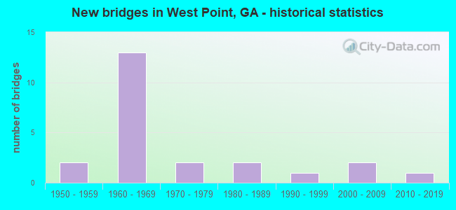
- New bridges - historical statistics
- 21950-1959
- 131960-1969
- 21970-1979
- 21980-1989
- 11990-1999
- 22000-2009
- 12010-2019


- Bridge Condition - Deck
- 76.2%Good
- 19.0%Satisfactory
- 4.8%Fair

- Bridge Condition - Superstructure
- 23.8%Very good
- 66.7%Good
- 9.5%Satisfactory

- Bridge Condition - Substructure
- 80.0%Good
- 15.0%Satisfactory
- 5.0%Serious

- Bridge Condition - Channel
- 37.5%Very good
- 43.8%Good
- 6.3%Satisfactory
- 12.5%Fair
Find on map >> Show street view
Structure Number: 1450016, Location: 5.5 MI SE OF WEST POINT (Lat: 32.815839, Lng: -85.104878), Route carried "on" structure: State highway 103, Year Built: 1958, Status: Open, Structure Length: 2.74m (8.99ft), Average Daily Traffic: 1,980 (year 2012), Truck Traffic: 1%, Average Future Daily Traffic: 2,970 (year 2032), Design Load: H 15, Features Intersected: SAND CREEK
Minimum Vertical Clearance: 30+ m (98+ ft), Kilometerpoint: 14.484, Lanes on structure: 2, Base Highway Network: Yes, Owner: State Highway Agency, Approaching Roadway Width: 7.9m (25.9ft), Material/Design: Concrete, Design/Construction: Tee Beam, Number Of Spans In Main Unit: 3, Length of Maximum Span: 9.1m (29.9ft), Curb or Sidewalk Widths: Left: 0.6m (2.0ft), Right: 0.6m (2.0ft), Curb-To-Curb Width: 8.0m (26.2ft), Out-to-Out Width: 9.2m (30.2ft)
Condition: Deck: Satisfactory, Superstructure: Good, Substructure: Good, Channel: Fair, Operating Rating: 35.3 metric tons, Method Used To Determine Operating Rating: Allowable Stress (AS), Inventory Rating: 21.7 metric tons, Method Used To Determine Inventory Rating: Allowable Stress (AS), Structural Evaluation: Somewhat better than minimum adequacy, Deck Geometry: Meets minimum limits, Waterway Adequacy: Equal to present desirable criteria, Approach Roadway Alignment: Equal to present desirable criteria, Length Of Structure Improvement: 9.17m (30.09ft), Designated Inspection Frequency: Every 24 months, Inspection Date: September 2021, Bridge Improvement Cost: $352,000, Roadway Improvement Cost: $35,000, Total Project Cost: $527,000, Deck Structure Type: Concrete Cast-file-Place
Find on map >> Show street view
Structure Number: 1450018, Location: 2 MI E OF WEST POINT (Lat: 32.864589, Lng: -85.138339), Route carried "on" structure: State highway 103, Year Built: 1957, Status: Open, Structure Length: 0.82m (2.69ft), Average Daily Traffic: 5,050 (year 2012), Truck Traffic: 1%, Average Future Daily Traffic: 7,575 (year 2032), Design Load: H 15, Features Intersected: CHATTAHOOCHEE RIV TRIB
Minimum Vertical Clearance: 30+ m (98+ ft), Kilometerpoint: 20.921, Lanes on structure: 2, Base Highway Network: Yes, Owner: State Highway Agency, Approaching Roadway Width: 7.9m (25.9ft), Skew: 3 degrees, Material/Design: Concrete, Design/Construction: Culvert, Number Of Spans In Main Unit: 3, Length of Maximum Span: 2.4m (7.9ft)
Condition: Channel: Satisfactory, Culverts: Good, Structural Evaluation: Better than present minimum criteria, Waterway Adequacy: Equal to present minimum criteria, Approach Roadway Alignment: Better than present minimum criteria, Designated Inspection Frequency: Every 24 months, Inspection Date: September 2021, Bridge Improvement Cost: $105,000, Roadway Improvement Cost: $11,000, Total Project Cost: $158,000
Find on map >> Show street view
Structure Number: 145005, Location: .1 MI E OF WEST POINT (Lat: 32.867278, Lng: -85.165039), Route carried "on" structure: County highway 1427, Year Built: 1963, Status: Open, Structure Length: 6.77m (22.21ft), Average Daily Traffic: 310 (year 2011), Truck Traffic: 1%, Average Future Daily Traffic: 465 (year 2030), Design Load: H 15, Features Intersected: I-85@ 1.21N, Facility Carried by Structure: OLD WEST POINT RD
Minimum Vertical Clearance: 30+ m (98+ ft), Kilometerpoint: 0.000, Lanes on structure: 2, Lanes under structure: 4, Base Highway Network: Yes, Owner: State Highway Agency, Approaching Roadway Width: 7.3m (24.0ft), Skew: 2 degrees, Material/Design: Steel continuous, Design/Construction: Stringer/Multi-beam, Number Of Spans In Main Unit: 4, Length of Maximum Span: 23.2m (76.1ft), Curb or Sidewalk Widths: Left: 0.6m (2.0ft), Right: 0.6m (2.0ft), Curb-To-Curb Width: 8.5m (27.9ft), Out-to-Out Width: 9.9m (32.5ft)
Condition: Deck: Good, Superstructure: Good, Substructure: Good, Operating Rating: 35.3 metric tons, Method Used To Determine Operating Rating: Allowable Stress (AS), Inventory Rating: 18.1 metric tons, Method Used To Determine Inventory Rating: Allowable Stress (AS), Structural Evaluation: Somewhat better than minimum adequacy, Deck Geometry: Equal to present minimum criteria, Underclear: High priority of corrective action, Approach Roadway Alignment: Somewhat better than minimum adequacy, Designated Inspection Frequency: Every 24 months, Inspection Date: September 2021, Bridge Improvement Cost: $867,000, Roadway Improvement Cost: $87,000, Total Project Cost: $1,301,000, Deck Structure Type: Concrete Cast-file-Place, Wearing Surface/Protective System: Wearing Surface: Epoxy Overlay
Find on map >> Show street view
Structure Number: 1450051, Location: .5 MI E OF WEST POINT (Lat: 32.865789, Lng: -85.159358), Route carried "on" structure: County highway 1427, Year Built: 1993, Status: Open, Structure Length: 7.92m (25.98ft), Average Daily Traffic: 370 (year 2012), Truck Traffic: 1%, Average Future Daily Traffic: 555 (year 2032), Design Load: HS 20+Mod, Features Intersected: LONG CANE CREEK, Facility Carried by Structure: OLD WEST POINT RD
Minimum Vertical Clearance: 30+ m (98+ ft), Kilometerpoint: 0.000, Lanes on structure: 2, Base Highway Network: Yes, Owner: County Highway Agency, Approaching Roadway Width: 7.3m (24.0ft), Material/Design: Prestressed concrete, Design/Construction: Stringer/Multi-beam, Number Of Spans In Main Unit: 3, Length of Maximum Span: 27.4m (89.9ft), Curb-To-Curb Width: 9.2m (30.2ft), Out-to-Out Width: 10.1m (33.1ft)
Condition: Deck: Good, Superstructure: Very good, Substructure: Good, Channel: Very good, Operating Rating: 50.8 metric tons, Method Used To Determine Operating Rating: Load Factor (LF), Inventory Rating: 30.8 metric tons, Method Used To Determine Inventory Rating: Load Factor (LF), Structural Evaluation: Better than present minimum criteria, Deck Geometry: Equal to present minimum criteria, Waterway Adequacy: Equal to present desirable criteria, Approach Roadway Alignment: Better than present minimum criteria, Designated Inspection Frequency: Every 24 months, Inspection Date: September 2021, Bridge Improvement Cost: $1,016,000, Roadway Improvement Cost: $102,000, Total Project Cost: $1,524,000, Deck Structure Type: Concrete Precast Panels
Find on map >> Show street view
Structure Number: 1455067, Location: 4 MI SE OF WEST POINT (Lat: 32.836858, Lng: -85.116008), Route carried "on" structure: State highway 103, Year Built: 2014, Status: Open, Structure Length: 10.97m (35.99ft), Average Daily Traffic: 4,110 (year 2014), Truck Traffic: 1%, Average Future Daily Traffic: 6,165 (year 2032), Design Load: HS 20+Mod, Features Intersected: FLAT SHOALS CREEK
Minimum Vertical Clearance: 30+ m (98+ ft), Kilometerpoint: 17.703, Lanes on structure: 2, Base Highway Network: Yes, Owner: State Highway Agency, Approaching Roadway Width: 7.9m (25.9ft), Skew: 2 degrees, Material/Design: Prestressed concrete, Design/Construction: Stringer/Multi-beam, Number Of Spans In Main Unit: 3, Length of Maximum Span: 41.1m (134.8ft), Curb-To-Curb Width: 12.2m (40.0ft), Out-to-Out Width: 13.2m (43.3ft)
Condition: Deck: Good, Superstructure: Good, Substructure: Good, Channel: Very good, Operating Rating: 71.6 metric tons, Method Used To Determine Operating Rating: Load Factor (LF), Inventory Rating: 38.1 metric tons, Method Used To Determine Inventory Rating: Load Factor (LF), Structural Evaluation: Better than present minimum criteria, Deck Geometry: Equal to present minimum criteria, Waterway Adequacy: Equal to present desirable criteria, Approach Roadway Alignment: Equal to present desirable criteria, Length Of Structure Improvement: 13.17m (43.21ft), Designated Inspection Frequency: Every 24 months, Inspection Date: September 2021, Bridge Improvement Cost: $31,968,000, Roadway Improvement Cost: $3,197,000, Total Project Cost: $47,952,000 ( Estimate for 2015), Deck Structure Type: Concrete Cast-file-Place
Find on map >> Show street view
Structure Number: 2850013, Location: IN WEST POINT (Lat: 32.877650, Lng: -85.180258), Route carried "on" structure: US 29, Year Built: 1977, Status: Open, Structure Length: 19.02m (62.40ft), Average Daily Traffic: 13,100 (year 2012), Truck Traffic: 1%, Average Future Daily Traffic: 19,650 (year 2032), Design Load: HS 20+Mod, Features Intersected: CHATTAHOOCHEE RIVER
Minimum Vertical Clearance: 30+ m (98+ ft), Kilometerpoint: 0.000, Lanes on structure: 4, Base Highway Network: Yes, Owner: State Highway Agency, Approaching Roadway Width: 14.6m (47.9ft), Skew: 2 degrees, Material/Design: Steel continuous, Design/Construction: Stringer/Multi-beam, Number Of Spans In Main Unit: 5, Length of Maximum Span: 41.5m (136.2ft), Curb or Sidewalk Widths: Left: 1.8m (5.9ft), Right: 1.8m (5.9ft), Curb-To-Curb Width: 15.8m (51.8ft), Out-to-Out Width: 20.2m (66.3ft)
Condition: Deck: Satisfactory, Superstructure: Good, Substructure: Good, Channel: Good, Operating Rating: 56.2 metric tons, Method Used To Determine Operating Rating: Allowable Stress (AS), Inventory Rating: 32.6 metric tons, Method Used To Determine Inventory Rating: Allowable Stress (AS), Structural Evaluation: Better than present minimum criteria, Deck Geometry: Meets minimum limits, Waterway Adequacy: Equal to present desirable criteria, Approach Roadway Alignment: Better than present minimum criteria, Designated Inspection Frequency: Every 24 months, Underwater Inspection Frequency: Every 60 months, Inspection Date: September 2021, Underwater Inspection Date: June 2019, Bridge Improvement Cost: $3,768,000, Roadway Improvement Cost: $377,000, Total Project Cost: $5,652,000, Deck Structure Type: Concrete Cast-file-Place
Find on map >> Show street view
Structure Number: 2850022, Location: IN EAST WEST POINT (Lat: 32.878508, Lng: -85.153653), Route carried "on" structure: State highway 18, Year Built: 1963, Status: Open, Structure Length: 8.05m (26.41ft), Average Daily Traffic: 8,110 (year 2012), Truck Traffic: 1%, Average Future Daily Traffic: 12,165 (year 2032), Design Load: HS 20+Mod, Features Intersected: LONG CANE CREEK
Minimum Vertical Clearance: 30+ m (98+ ft), Kilometerpoint: 1.609, Lanes on structure: 2, Base Highway Network: Yes, Owner: State Highway Agency, Approaching Roadway Width: 7.3m (24.0ft), Skew: 12 degrees, Material/Design: Concrete, Design/Construction: Tee Beam, Number Of Spans In Main Unit: 7, Length of Maximum Span: 12.2m (40.0ft), Curb or Sidewalk Widths: Left: 0.6m (2.0ft), Right: 0.6m (2.0ft), Curb-To-Curb Width: 8.5m (27.9ft), Out-to-Out Width: 10.5m (34.4ft)
Condition: Deck: Satisfactory, Superstructure: Satisfactory, Substructure: Satisfactory, Channel: Good, Operating Rating: 48.0 metric tons, Method Used To Determine Operating Rating: Load Factor (LF), Inventory Rating: 29.0 metric tons, Method Used To Determine Inventory Rating: Load Factor (LF), Structural Evaluation: Equal to present minimum criteria, Deck Geometry: High priority of corrective action, Waterway Adequacy: Equal to present desirable criteria, Approach Roadway Alignment: Equal to present desirable criteria, Designated Inspection Frequency: Every 24 months, Underwater Inspection Frequency: Every 60 months, Inspection Date: December 2021, Underwater Inspection Date: June 2019, Bridge Improvement Cost: $1,032,000, Roadway Improvement Cost: $103,000, Total Project Cost: $1,547,000, Deck Structure Type: Concrete Cast-file-Place
Find on map >> Show street view
Structure Number: 2850025, Location: 5 MI E OF WEST POINT (Lat: 32.881389, Lng: -85.077789), Route carried "on" structure: State highway 18, Year Built: 1963, Status: Open, Structure Length: 7.32m (24.02ft), Average Daily Traffic: 1,520 (year 2012), Truck Traffic: 1%, Average Future Daily Traffic: 2,280 (year 2032), Design Load: H 20, Features Intersected: FLAT SHOALS CREEK
Minimum Vertical Clearance: 30+ m (98+ ft), Kilometerpoint: 9.656, Lanes on structure: 2, Base Highway Network: Yes, Owner: State Highway Agency, Approaching Roadway Width: 7.3m (24.0ft), Material/Design: Steel, Design/Construction: Stringer/Multi-beam, Number Of Spans In Main Unit: 4, Length of Maximum Span: 18.3m (60.0ft), Curb or Sidewalk Widths: Left: 0.6m (2.0ft), Right: 0.6m (2.0ft), Curb-To-Curb Width: 8.5m (27.9ft), Out-to-Out Width: 10.5m (34.4ft)
Condition: Deck: Satisfactory, Superstructure: Good, Substructure: Good, Channel: Very good, Operating Rating: 46.2 metric tons, Method Used To Determine Operating Rating: Load Factor (LF), Inventory Rating: 28.1 metric tons, Method Used To Determine Inventory Rating: Load Factor (LF), Structural Evaluation: Better than present minimum criteria, Deck Geometry: Somewhat better than minimum adequacy, Waterway Adequacy: Equal to present desirable criteria, Approach Roadway Alignment: Equal to present minimum criteria, Designated Inspection Frequency: Every 24 months, Inspection Date: September 2021, Bridge Improvement Cost: $938,000, Roadway Improvement Cost: $94,000, Total Project Cost: $1,407,000, Deck Structure Type: Concrete Cast-file-Place
Find on map >> Show street view
Structure Number: 285004, Location: 8 MI S OF LAGRANGE (Lat: 32.895261, Lng: -85.032114), Route carried "on" structure: State highway 219, Year Built: 1960, Status: Open, Structure Length: 2.93m (9.61ft), Average Daily Traffic: 2,490 (year 2012), Truck Traffic: 1%, Average Future Daily Traffic: 3,735 (year 2032), Design Load: H 20, Features Intersected: WILDCAT CREEK
Minimum Vertical Clearance: 30+ m (98+ ft), Kilometerpoint: 3.219, Lanes on structure: 2, Base Highway Network: Yes, Owner: State Highway Agency, Approaching Roadway Width: 8.5m (27.9ft), Material/Design: Concrete, Design/Construction: Tee Beam, Number Of Spans In Main Unit: 3, Length of Maximum Span: 9.8m (32.2ft), Curb or Sidewalk Widths: Left: 0.6m (2.0ft), Right: 0.6m (2.0ft), Curb-To-Curb Width: 8.5m (27.9ft), Out-to-Out Width: 10.5m (34.4ft)
Condition: Deck: Good, Superstructure: Good, Substructure: Satisfactory, Channel: Very good, Operating Rating: 32.6 metric tons, Method Used To Determine Operating Rating: Load Factor (LF), Inventory Rating: 19.9 metric tons, Method Used To Determine Inventory Rating: Load Factor (LF), Structural Evaluation: Somewhat better than minimum adequacy, Deck Geometry: Meets minimum limits, Waterway Adequacy: Equal to present desirable criteria, Approach Roadway Alignment: Equal to present minimum criteria, Designated Inspection Frequency: Every 24 months, Inspection Date: October 2021, Bridge Improvement Cost: $375,000, Roadway Improvement Cost: $38,000, Total Project Cost: $563,000, Deck Structure Type: Concrete Cast-file-Place, Wearing Surface/Protective System: Wearing Surface: Bituminous
Find on map >> Show street view
Structure Number: 2850049, Location: IN WEST POINT (Lat: 32.874475, Lng: -85.155825), Route carried "on" structure: Interstate 85, Year Built: 1963, Year Reconstructed: 1983, Status: Open, Structure Length: 9.51m (31.20ft), Average Daily Traffic: 33,790 (year 2012), Truck Traffic: 1%, Average Future Daily Traffic: 50,685 (year 2032), Design Load: HS 20+Mod, Features Intersected: LONG CANE CREEK
Minimum Vertical Clearance: 30+ m (98+ ft), Kilometerpoint: 3.219, Lanes on structure: 2, Base Highway Network: Yes, Owner: State Highway Agency, Approaching Roadway Width: 11.6m (38.1ft), Skew: 14 degrees, Material/Design: Concrete, Design/Construction: Tee Beam, Number Of Spans In Main Unit: 8, Length of Maximum Span: 11.9m (39.0ft), Curb-To-Curb Width: 12.9m (42.3ft), Out-to-Out Width: 13.9m (45.6ft)
Condition: Deck: Good, Superstructure: Good, Substructure: Good, Channel: Good, Operating Rating: 48.9 metric tons, Method Used To Determine Operating Rating: Load Factor (LF), Inventory Rating: 29.0 metric tons, Method Used To Determine Inventory Rating: Load Factor (LF), Structural Evaluation: Better than present minimum criteria, Deck Geometry: Superior to present desirable criteria, Waterway Adequacy: Equal to present desirable criteria, Approach Roadway Alignment: Equal to present desirable criteria, Designated Inspection Frequency: Every 24 months, Underwater Inspection Frequency: Every 60 months, Inspection Date: December 2021, Underwater Inspection Date: June 2019, Other Special Inspection Date: December 2020, Bridge Improvement Cost: $1,219,000, Roadway Improvement Cost: $122,000, Total Project Cost: $1,829,000, Deck Structure Type: Concrete Cast-file-Place, Wearing Surface/Protective System: Wearing Surface: Other
Find on map >> Show street view
Structure Number: 285005, Location: IN WEST POINT (Lat: 32.874800, Lng: -85.155839), Route carried "on" structure: Interstate 85, Year Built: 1963, Year Reconstructed: 1983, Status: Open, Structure Length: 9.51m (31.20ft), Average Daily Traffic: 33,790 (year 2012), Truck Traffic: 1%, Average Future Daily Traffic: 50,685 (year 2032), Design Load: HS 20+Mod, Features Intersected: LONG CANE CREEK
Minimum Vertical Clearance: 30+ m (98+ ft), Kilometerpoint: 3.219, Lanes on structure: 3, Base Highway Network: Yes, Owner: State Highway Agency, Approaching Roadway Width: 11.6m (38.1ft), Skew: 15 degrees, Material/Design: Concrete, Design/Construction: Tee Beam, Number Of Spans In Main Unit: 8, Length of Maximum Span: 11.9m (39.0ft), Curb-To-Curb Width: 16.5m (54.1ft), Out-to-Out Width: 17.4m (57.1ft)
Condition: Deck: Good, Superstructure: Good, Substructure: Good, Channel: Good, Operating Rating: 49.8 metric tons, Method Used To Determine Operating Rating: Load Factor (LF), Inventory Rating: 29.9 metric tons, Method Used To Determine Inventory Rating: Load Factor (LF), Structural Evaluation: Better than present minimum criteria, Deck Geometry: Equal to present minimum criteria, Waterway Adequacy: Equal to present desirable criteria, Approach Roadway Alignment: Equal to present desirable criteria, Designated Inspection Frequency: Every 24 months, Underwater Inspection Frequency: Every 60 months, Inspection Date: December 2021, Underwater Inspection Date: June 2019, Other Special Inspection Date: December 2020, Bridge Improvement Cost: $1,552,000, Roadway Improvement Cost: $155,000, Total Project Cost: $2,327,000, Deck Structure Type: Concrete Cast-file-Place, Wearing Surface/Protective System: Wearing Surface: Other
Find on map >> Show street view
Structure Number: 2850051, Location: IN WEST POINT (Lat: 32.877789, Lng: -85.151328), Route carried "on" structure: Interstate 85, Year Built: 1963, Year Reconstructed: 1983, Status: Open, Structure Length: 5.58m (18.31ft), Average Daily Traffic: 33,790 (year 2012), Truck Traffic: 1%, Average Future Daily Traffic: 50,685 (year 2032), Design Load: HS 20+Mod, Features Intersected: SR 18
Minimum Vertical Clearance: 30+ m (98+ ft), Kilometerpoint: 3.219, Lanes on structure: 2, Lanes under structure: 4, Base Highway Network: Yes, Owner: State Highway Agency, Approaching Roadway Width: 11.6m (38.1ft), Skew: 13 degrees, Material/Design: Steel continuous, Design/Construction: Stringer/Multi-beam, Number Of Spans In Main Unit: 4, Length of Maximum Span: 15.5m (50.9ft), Curb-To-Curb Width: 12.8m (42.0ft), Out-to-Out Width: 13.8m (45.3ft)
Condition: Deck: Good, Superstructure: Good, Substructure: Good, Operating Rating: 40.8 metric tons, Method Used To Determine Operating Rating: Load Factor (LF), Inventory Rating: 24.4 metric tons, Method Used To Determine Inventory Rating: Load Factor (LF), Structural Evaluation: Equal to present minimum criteria, Deck Geometry: Equal to present desirable criteria, Underclear: Somewhat better than minimum adequacy, Approach Roadway Alignment: Equal to present desirable criteria, Designated Inspection Frequency: Every 24 months, Inspection Date: October 2021, Other Special Inspection Date: December 2020, Bridge Improvement Cost: $715,000, Roadway Improvement Cost: $72,000, Total Project Cost: $1,073,000, Deck Structure Type: Concrete Cast-file-Place, Wearing Surface/Protective System: Wearing Surface: Other
Find on map >> Show street view
Structure Number: 2850052, Location: IN WEST POINT (Lat: 32.877897, Lng: -85.151658), Route carried "on" structure: Interstate 85, Year Built: 1963, Year Reconstructed: 1983, Status: Open, Structure Length: 5.58m (18.31ft), Average Daily Traffic: 30,150 (year 2012), Truck Traffic: 1%, Average Future Daily Traffic: 45,225 (year 2032), Design Load: HS 20+Mod, Features Intersected: SR 18
Minimum Vertical Clearance: 30+ m (98+ ft), Kilometerpoint: 3.219, Lanes on structure: 2, Lanes under structure: 4, Base Highway Network: Yes, Owner: State Highway Agency, Approaching Roadway Width: 11.6m (38.1ft), Skew: 13 degrees, Material/Design: Steel continuous, Design/Construction: Stringer/Multi-beam, Number Of Spans In Main Unit: 4, Length of Maximum Span: 15.5m (50.9ft), Curb-To-Curb Width: 12.8m (42.0ft), Out-to-Out Width: 13.7m (44.9ft)
Condition: Deck: Good, Superstructure: Very good, Substructure: Good, Operating Rating: 40.8 metric tons, Method Used To Determine Operating Rating: Load Factor (LF), Inventory Rating: 24.4 metric tons, Method Used To Determine Inventory Rating: Load Factor (LF), Structural Evaluation: Equal to present minimum criteria, Deck Geometry: Equal to present desirable criteria, Underclear: Somewhat better than minimum adequacy, Approach Roadway Alignment: Equal to present desirable criteria, Designated Inspection Frequency: Every 24 months, Inspection Date: October 2021, Other Special Inspection Date: December 2020, Bridge Improvement Cost: $715,000, Roadway Improvement Cost: $72,000, Total Project Cost: $1,073,000, Deck Structure Type: Concrete Cast-file-Place, Wearing Surface/Protective System: Wearing Surface: Other
Find on map >> Show street view
Structure Number: 2850053, Location: NE EDGE OF WEST POINT (Lat: 32.880639, Lng: -85.147489), Route carried "on" structure: Interstate 85, Year Built: 1963, Status: Open, Structure Length: 0.73m (2.40ft), Average Daily Traffic: 30,150 (year 2012), Truck Traffic: 1%, Average Future Daily Traffic: 45,225 (year 2032), Design Load: HS 20+Mod, Features Intersected: LONG CANE CREEK TRIB
Minimum Vertical Clearance: 30+ m (98+ ft), Kilometerpoint: 4.828, Lanes on structure: 5, Base Highway Network: Yes, Owner: State Highway Agency, Approaching Roadway Width: 23.2m (76.1ft), Skew: 14 degrees, Material/Design: Concrete, Design/Construction: Culvert, Number Of Spans In Main Unit: 2, Length of Maximum Span: 3.4m (11.2ft)
Condition: Channel: Very good, Culverts: Good, Structural Evaluation: Better than present minimum criteria, Waterway Adequacy: Equal to present desirable criteria, Approach Roadway Alignment: Equal to present desirable criteria, Designated Inspection Frequency: Every 24 months, Inspection Date: November 2021, Bridge Improvement Cost: $145,000, Roadway Improvement Cost: $14,000, Total Project Cost: $217,000
Find on map >> Show street view
Structure Number: 2850054, Location: 2.5 MI NE OF WEST POINT (Lat: 32.911039, Lng: -85.120278), Route carried "on" structure: Interstate 85, Year Built: 1966, Status: Open, Structure Length: 5.64m (18.50ft), Average Daily Traffic: 30,150 (year 2012), Truck Traffic: 1%, Average Future Daily Traffic: 45,225 (year 2032), Design Load: HS 20+Mod, Features Intersected: CR 413 WEBB ROAD
Minimum Vertical Clearance: 30+ m (98+ ft), Kilometerpoint: 8.047, Lanes on structure: 2, Lanes under structure: 2, Base Highway Network: Yes, Owner: State Highway Agency, Approaching Roadway Width: 11.6m (38.1ft), Skew: 13 degrees, Material/Design: Steel, Design/Construction: Stringer/Multi-beam, Number Of Spans In Main Unit: 3, Length of Maximum Span: 21.6m (70.9ft), Curb-To-Curb Width: 11.6m (38.1ft), Out-to-Out Width: 12.3m (40.4ft)
Condition: Deck: Good, Superstructure: Good, Substructure: Good, Operating Rating: 56.2 metric tons, Method Used To Determine Operating Rating: Load Factor (LF), Inventory Rating: 33.5 metric tons, Method Used To Determine Inventory Rating: Load Factor (LF), Structural Evaluation: Better than present minimum criteria, Deck Geometry: Equal to present minimum criteria, Underclear: Somewhat better than minimum adequacy, Approach Roadway Alignment: Equal to present desirable criteria, Designated Inspection Frequency: Every 24 months, Inspection Date: October 2021, Bridge Improvement Cost: $723,000, Roadway Improvement Cost: $72,000, Total Project Cost: $1,084,000, Deck Structure Type: Concrete Cast-file-Place, Wearing Surface/Protective System: Wearing Surface: Epoxy Overlay
Find on map >> Show street view
Structure Number: 2850055, Location: 2.5 MI NE OF WEST POINT (Lat: 32.911019, Lng: -85.120669), Route carried "on" structure: Interstate 85, Year Built: 1966, Status: Open, Structure Length: 5.30m (17.39ft), Average Daily Traffic: 30,150 (year 2012), Truck Traffic: 1%, Average Future Daily Traffic: 45,225 (year 2032), Design Load: HS 20+Mod, Features Intersected: CR 413 WEBB ROAD
Minimum Vertical Clearance: 30+ m (98+ ft), Kilometerpoint: 8.047, Lanes on structure: 2, Lanes under structure: 2, Base Highway Network: Yes, Owner: State Highway Agency, Approaching Roadway Width: 11.6m (38.1ft), Skew: 13 degrees, Material/Design: Steel, Design/Construction: Stringer/Multi-beam, Number Of Spans In Main Unit: 3, Length of Maximum Span: 21.6m (70.9ft), Curb-To-Curb Width: 11.6m (38.1ft), Out-to-Out Width: 12.3m (40.4ft)
Condition: Deck: Good, Superstructure: Very good, Substructure: Good, Operating Rating: 56.2 metric tons, Method Used To Determine Operating Rating: Load Factor (LF), Inventory Rating: 33.5 metric tons, Method Used To Determine Inventory Rating: Load Factor (LF), Structural Evaluation: Better than present minimum criteria, Deck Geometry: Equal to present minimum criteria, Underclear: Somewhat better than minimum adequacy, Approach Roadway Alignment: Equal to present desirable criteria, Designated Inspection Frequency: Every 24 months, Inspection Date: October 2021, Bridge Improvement Cost: $680,000, Roadway Improvement Cost: $68,000, Total Project Cost: $1,020,000, Deck Structure Type: Concrete Cast-file-Place, Wearing Surface/Protective System: Wearing Surface: Epoxy Overlay
Find on map >> Show street view
Structure Number: 2850088, Location: NW CORNER OF WEST POINT (Lat: 32.889472, Lng: -85.184189), Route carried "on" structure: County highway 1427, Year Built: 1964, Status: Open, Structure Length: 7.32m (24.02ft), Average Daily Traffic: 2,430 (year 2012), Truck Traffic: 1%, Average Future Daily Traffic: 3,645 (year 2032), Design Load: HS 20+Mod, Features Intersected: CHATTAHOOCHEE RIVER O/F, Facility Carried by Structure: 3RD AVENUE
Minimum Vertical Clearance: 30+ m (98+ ft), Kilometerpoint: 1.609, Lanes on structure: 2, Base Highway Network: Yes, Owner: City or Municipal Highway Agency, Approaching Roadway Width: 7.3m (24.0ft), Material/Design: Concrete, Design/Construction: Tee Beam, Number Of Spans In Main Unit: 6, Length of Maximum Span: 12.2m (40.0ft), Curb or Sidewalk Widths: Left: 0.6m (2.0ft), Right: 0.6m (2.0ft), Curb-To-Curb Width: 8.5m (27.9ft), Out-to-Out Width: 10.4m (34.1ft)
Condition: Deck: Good, Superstructure: Good, Substructure: Good, Channel: Good, Operating Rating: 37.1 metric tons, Method Used To Determine Operating Rating: Load Factor (LF), Inventory Rating: 21.7 metric tons, Method Used To Determine Inventory Rating: Load Factor (LF), Structural Evaluation: Somewhat better than minimum adequacy, Deck Geometry: Meets minimum limits, Waterway Adequacy: Equal to present desirable criteria, Approach Roadway Alignment: Better than present minimum criteria, Length Of Structure Improvement: 13.75m (45.11ft), Designated Inspection Frequency: Every 24 months, Underwater Inspection Frequency: Every 60 months, Inspection Date: October 2021, Underwater Inspection Date: June 2019, Bridge Improvement Cost: $938,000, Roadway Improvement Cost: $94,000, Total Project Cost: $1,407,000, Deck Structure Type: Concrete Cast-file-Place
Find on map >> Show street view
Structure Number: 2855004, Location: 8 MI SW OF LAGRANGE (Lat: 32.896869, Lng: -85.092644), Route carried "on" structure: County highway 72, Year Built: 1970, Status: Posted for load, Structure Length: 3.29m (10.79ft), Average Daily Traffic: 490 (year 2012), Truck Traffic: 1%, Average Future Daily Traffic: 735 (year 2032), Features Intersected: BIG BRANCH, Facility Carried by Structure: ADAMS ROAD
Minimum Vertical Clearance: 30+ m (98+ ft), Kilometerpoint: 1.609, Lanes on structure: 2, Base Highway Network: Yes, Owner: County Highway Agency, Approaching Roadway Width: 5.5m (18.0ft), Material/Design: Steel, Design/Construction: Stringer/Multi-beam, Number Of Spans In Main Unit: 6, Length of Maximum Span: 5.5m (18.0ft), Curb-To-Curb Width: 7.2m (23.6ft), Out-to-Out Width: 7.5m (24.6ft)
Condition: Deck: Good, Superstructure: Satisfactory, Substructure: Serious, Channel: Good, Operating Rating: 10.8 metric tons, Method Used To Determine Operating Rating: Load Factor (LF), Inventory Rating: 7.2 metric tons, Method Used To Determine Inventory Rating: Load Factor (LF), Structural Evaluation: High priority of replacement, Deck Geometry: Meets minimum limits, Waterway Adequacy: Better than present minimum criteria, Approach Roadway Alignment: Somewhat better than minimum adequacy, Bridge Posting: Required (Relationship of Operating Rating to Maximum Legal Load: 30.0 - 39.9% below), Length Of Structure Improvement: 43.56m (142.91ft), Designated Inspection Frequency: Every 24 months, Inspection Date: November 2021, Bridge Improvement Cost: $422,000, Roadway Improvement Cost: $42,000, Total Project Cost: $633,000, Deck Structure Type: Corrugated Steel, Wearing Surface/Protective System: Wearing Surface: Bituminous
Find on map >> Show street view
Structure Number: 2855007, Location: 4 MI N OF WEST POINT (Lat: 32.944117, Lng: -85.132731), Route carried "on" structure: County highway 98, Year Built: 1986, Status: Open, Structure Length: 3.05m (10.01ft), Average Daily Traffic: 1,400 (year 2012), Truck Traffic: 1%, Average Future Daily Traffic: 2,100 (year 2032), Design Load: H 15, Features Intersected: LONG CANE CREEK, Facility Carried by Structure: GABBETTVILLE ROAD
Minimum Vertical Clearance: 30+ m (98+ ft), Kilometerpoint: 8.047, Lanes on structure: 2, Base Highway Network: Yes, Owner: County Highway Agency, Approaching Roadway Width: 6.7m (22.0ft), Material/Design: Steel, Design/Construction: Stringer/Multi-beam, Number Of Spans In Main Unit: 2, Length of Maximum Span: 15.2m (49.9ft), Curb-To-Curb Width: 7.1m (23.3ft), Out-to-Out Width: 8.3m (27.2ft)
Condition: Deck: Good, Superstructure: Good, Substructure: Satisfactory, Channel: Very good, Operating Rating: 41.7 metric tons, Method Used To Determine Operating Rating: Load Factor (LF), Inventory Rating: 24.4 metric tons, Method Used To Determine Inventory Rating: Load Factor (LF), Structural Evaluation: Equal to present minimum criteria, Deck Geometry: High priority of corrective action, Waterway Adequacy: Equal to present minimum criteria, Approach Roadway Alignment: Better than present minimum criteria, Length Of Structure Improvement: 9.54m (31.30ft), Designated Inspection Frequency: Every 24 months, Underwater Inspection Frequency: Every 60 months, Inspection Date: September 2021, Underwater Inspection Date: June 2019, Bridge Improvement Cost: $391,000, Roadway Improvement Cost: $39,000, Total Project Cost: $586,000, Deck Structure Type: Concrete Cast-file-Place, Wearing Surface/Protective System: Wearing Surface: Bituminous
Find on map >> Show street view
Structure Number: 2855036, Location: .8 MI E OF SR 14 (Lat: 32.910761, Lng: -85.142953), Route carried "on" structure: County highway 413, Year Built: 1987, Status: Open, Structure Length: 6.10m (20.01ft), Average Daily Traffic: 490 (year 2012), Truck Traffic: 1%, Average Future Daily Traffic: 735 (year 2032), Design Load: HS 20+Mod, Features Intersected: LONG CANE CREEK, Facility Carried by Structure: WEBB ROAD
Minimum Vertical Clearance: 30+ m (98+ ft), Kilometerpoint: 3.219, Lanes on structure: 2, Base Highway Network: Yes, Owner: City or Municipal Highway Agency, Approaching Roadway Width: 6.7m (22.0ft), Material/Design: Concrete, Design/Construction: Tee Beam, Number Of Spans In Main Unit: 5, Length of Maximum Span: 12.2m (40.0ft), Curb-To-Curb Width: 11.0m (36.1ft), Out-to-Out Width: 12.0m (39.4ft)
Condition: Deck: Good, Superstructure: Good, Substructure: Good, Channel: Good, Operating Rating: 54.4 metric tons, Method Used To Determine Operating Rating: Load Factor (LF), Inventory Rating: 32.6 metric tons, Method Used To Determine Inventory Rating: Load Factor (LF), Structural Evaluation: Better than present minimum criteria, Deck Geometry: Better than present minimum criteria, Waterway Adequacy: Equal to present desirable criteria, Approach Roadway Alignment: Better than present minimum criteria, Designated Inspection Frequency: Every 24 months, Underwater Inspection Frequency: Every 60 months, Inspection Date: September 2021, Underwater Inspection Date: June 2019, Bridge Improvement Cost: $781,000, Roadway Improvement Cost: $78,000, Total Project Cost: $1,172,000, Deck Structure Type: Concrete Cast-file-Place
Find on map >> Show street view
Structure Number: 285507, Location: 1 MI NE OF WEST POINT (Lat: 32.883811, Lng: -85.151517), Route carried "on" structure: City street 708, Year Built: 2008, Status: Open, Structure Length: 9.14m (29.99ft), Average Daily Traffic: 490 (year 2012), Truck Traffic: 1%, Average Future Daily Traffic: 735 (year 2032), Design Load: HS 20+Mod, Features Intersected: LONG CANE CREEK, Facility Carried by Structure: KIA PARKWAY
Minimum Vertical Clearance: 30+ m (98+ ft), Kilometerpoint: 0.000, Lanes on structure: 4, Base Highway Network: Yes, Owner: City or Municipal Highway Agency, Approaching Roadway Width: 21.9m (71.9ft), Skew: 20 degrees, Material/Design: Prestressed concrete, Design/Construction: Stringer/Multi-beam, Number Of Spans In Main Unit: 6, Length of Maximum Span: 30.5m (100.1ft), Curb-To-Curb Width: 26.8m (87.9ft), Out-to-Out Width: 27.8m (91.2ft)
Condition: Deck: Good, Superstructure: Very good, Substructure: Good, Channel: Fair, Operating Rating: 50.8 metric tons, Method Used To Determine Operating Rating: Load Factor (LF), Inventory Rating: 29.9 metric tons, Method Used To Determine Inventory Rating: Load Factor (LF), Structural Evaluation: Better than present minimum criteria, Deck Geometry: Superior to present desirable criteria, Waterway Adequacy: Superior to present desirable criteria, Approach Roadway Alignment: Superior to present desirable criteria, Designated Inspection Frequency: Every 24 months, Inspection Date: October 2021, Bridge Improvement Cost: $1,812,000, Roadway Improvement Cost: $181,000, Total Project Cost: $2,717,000, Deck Structure Type: Concrete Cast-file-Place
Find on map >> Show street view
Structure Number: 2855071, Location: 5 MI NE OF WEST POINT (Lat: 32.928025, Lng: -85.109181), Route carried "on" structure: City street 709, Year Built: 2009, Status: Open, Structure Length: 11.70m (38.39ft), Average Daily Traffic: 1,400 (year 2012), Truck Traffic: 1%, Average Future Daily Traffic: 2,100 (year 2032), Design Load: HS 20+Mod, Features Intersected: I-85, Facility Carried by Structure: KIA BOULEVARD
Minimum Vertical Clearance: 30+ m (98+ ft), Kilometerpoint: 1.609, Lanes on structure: 6, Lanes under structure: 4, Base Highway Network: Yes, Owner: State Highway Agency, Approaching Roadway Width: 27.4m (89.9ft), Skew: 20 degrees, Material/Design: Prestressed concrete, Design/Construction: Stringer/Multi-beam, Number Of Spans In Main Unit: 4, Length of Maximum Span: 40.2m (131.9ft), Curb-To-Curb Width: 35.4m (116.1ft), Out-to-Out Width: 36.3m (119.1ft)
Condition: Deck: Good, Superstructure: Very good, Substructure: Good, Operating Rating: 49.8 metric tons, Method Used To Determine Operating Rating: Load Factor (LF), Inventory Rating: 29.9 metric tons, Method Used To Determine Inventory Rating: Load Factor (LF), Structural Evaluation: Better than present minimum criteria, Deck Geometry: Superior to present desirable criteria, Underclear: Superior to present desirable criteria, Approach Roadway Alignment: Superior to present desirable criteria, Designated Inspection Frequency: Every 24 months, Inspection Date: October 2021, Bridge Improvement Cost: $3,137,000, Roadway Improvement Cost: $314,000, Total Project Cost: $4,706,000, Deck Structure Type: Concrete Cast-file-Place, Wearing Surface/Protective System: Wearing Surface: Epoxy Overlay
Find on map >> Show street view
Structure Number: CEPSAMGA0000004, Location: 5 MI NW OF WEST POINT, GA (Lat: 32.928333, Lng: -85.186667), Route carried "on" structure: Federal lands road , Year Built: 1967, Status: Posted for load, Structure Length: 10.67m (35.01ft), Average Daily Traffic: 600 (year 2021), Truck Traffic: 20%, Average Future Daily Traffic: 550 (year 2039), Design Load: HS 20, Features Intersected: WEST POINT SPILLWAY, Facility Carried by Structure: W.P. DAM ACCESS RD
Minimum Vertical Clearance: 30+ m (98+ ft), Kilometerpoint: 0.000, Lanes on structure: 2, Owner: Corps of Engineers (Civil), Approaching Roadway Width: 6.4m (21.0ft), Material/Design: Concrete, Design/Construction: Stringer/Multi-beam, Number Of Spans In Main Unit: 6, Length of Maximum Span: 18.2m (59.7ft), Curb or Sidewalk Widths: Left: 0.3m (1.0ft), Right: 0.3m (1.0ft), Curb-To-Curb Width: 5.4m (17.7ft), Out-to-Out Width: 6.4m (21.0ft)
Condition: Deck: Fair, Superstructure: Good, Operating Rating: 43.5 metric tons, Method Used To Determine Operating Rating: Load Factor (LF), Inventory Rating: 32.7 metric tons, Method Used To Determine Inventory Rating: Load Factor (LF), Structural Evaluation: Better than present minimum criteria, Deck Geometry: High priority of replacement, Waterway Adequacy: Superior to present desirable criteria, Approach Roadway Alignment: Meets minimum limits, Length Of Structure Improvement: 10.97m (35.99ft), Designated Inspection Frequency: Every 24 months, Inspection Date: April 2021, Bridge Improvement Cost: $5,000, Roadway Improvement Cost: $10,000, Total Project Cost: $20,000 ( Estimate for 2021), Deck Structure Type: Concrete Cast-file-Place, Wearing Surface/Protective System: Wearing Surface: Monolithic Concrete
Find on map >> Show street view
Structure Number: 145005, Location: .1 MI E OF WEST POINT (Lat: 32.867278, Lng: -85.165039), Route carried "under" structure: Interstate 85, Structure Length: 0. m, Average Daily Traffic: 23,100 (year 1998), Truck Traffic: 15%, Features Intersected: FAS 1427 OLD W POINT RD., Facility Carried by Structure: OLD WEST POINT RD
Minimum Vertical Clearance: 5.15m (16.90ft), Kilometerpoint: 1.609, Lanes on structure: 2, Length of Maximum Span: 0.0m
Find on map >> Show street view
Structure Number: 2850051, Location: IN WEST POINT (Lat: 32.877789, Lng: -85.151328), Route carried "under" structure: State highway 18, Structure Length: 0. m, Average Daily Traffic: 4,400 (year 2009), Truck Traffic: 1%, Features Intersected: I-85 NBL (SR 403), Facility Carried by Structure: I-85 (NBL)
Minimum Vertical Clearance: 5.74m (18.83ft), Kilometerpoint: 3.219, Lanes on structure: 2, Length of Maximum Span: 0.0m
Find on map >> Show street view
Structure Number: 2850052, Location: IN WEST POINT (Lat: 32.877897, Lng: -85.151658), Route carried "under" structure: State highway 18, Structure Length: 0. m, Average Daily Traffic: 4,400 (year 2009), Truck Traffic: 1%, Features Intersected: I-85 SBL (SR 403), Facility Carried by Structure: I-85 (SBL)
Minimum Vertical Clearance: 5.33m (17.49ft), Kilometerpoint: 1.609, Lanes on structure: 2, Length of Maximum Span: 0.0m
Find on map >> Show street view
Structure Number: 2850054, Location: 2.5 MI NE OF WEST POINT (Lat: 32.911039, Lng: -85.120278), Route carried "under" structure: County highway 413, Structure Length: 0. m, Average Daily Traffic: 660 (year 1999), Truck Traffic: 1%, Features Intersected: I-85 NBL (SR 403), Facility Carried by Structure: I-85 (NBL)
Minimum Vertical Clearance: 7.69m (25.23ft), Kilometerpoint: 1.609, Lanes on structure: 2, Length of Maximum Span: 0.0m
Find on map >> Show street view
Structure Number: 2850055, Location: 2.5 MI NE OF WEST POINT (Lat: 32.911019, Lng: -85.120669), Route carried "under" structure: County highway 413, Structure Length: 0. m, Average Daily Traffic: 660 (year 1998), Truck Traffic: 1%, Features Intersected: I-85 SBL (SR 403), Facility Carried by Structure: I-85 (SBL)
Minimum Vertical Clearance: 7.41m (24.31ft), Kilometerpoint: 1.609, Lanes on structure: 2, Length of Maximum Span: 0.0m
Find on map >> Show street view
Structure Number: 2855071, Location: 5 MI NE OF WEST POINT (Lat: 32.928025, Lng: -85.109181), Route carried "under" structure: Interstate 85, Structure Length: 0. m, Average Daily Traffic: 23,700 (year 2009), Truck Traffic: 1%, Features Intersected: KIA BOULEVARD, Facility Carried by Structure: KIA BOULEVARD
Minimum Vertical Clearance: 7.21m (23.65ft), Kilometerpoint: 8.047, Lanes on structure: 6, Length of Maximum Span: 0.0m