Bridge Statistics for West Richland, Washington (WA)
Condition, Traffic, Stress, Structural Evaluation, Project Costs
- National Bridge Inventory (NBI) Statistics
- 14Number of bridges
- 194ft / 58.5mTotal length
- $25,555,000Total costs
- 98,943Total average daily traffic
- 14,380Total average daily truck traffic
- National Bridge Inventory (NBI) Registered Bridges for West Richland
- No street view available for this location
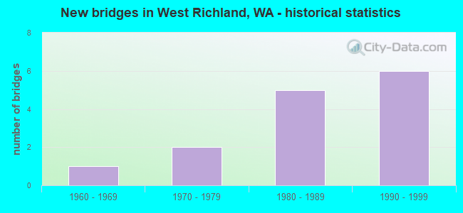
- New bridges - historical statistics
- 11960-1969
- 21970-1979
- 51980-1989
- 61990-1999
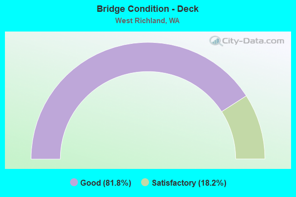
- Bridge Condition - Deck
- 81.8%Good
- 18.2%Satisfactory
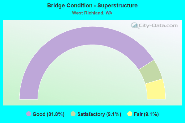
- Bridge Condition - Superstructure
- 81.8%Good
- 9.1%Satisfactory
- 9.1%Fair

- Bridge Condition - Substructure
- 81.8%Good
- 18.2%Satisfactory
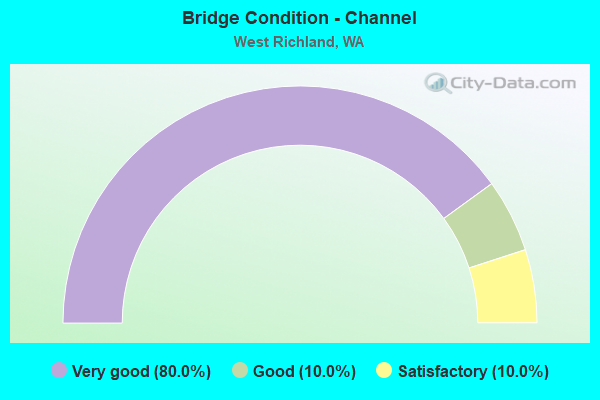
- Bridge Condition - Channel
- 80.0%Very good
- 10.0%Good
- 10.0%Satisfactory
Find on map >> Show street view
Structure Number: 12451C, Location: JCT I-182 (Lat: 46.244472, Lng: -119.362694), Route carried "on" structure: Interstate 82, Year Built: 1984, Status: Open, Structure Length: 7.80m (25.59ft), Average Daily Traffic: 13,127 (year 2019), Truck Traffic: 21%, Average Future Daily Traffic: 16,697 (year 2039), Design Load: HS 20, Features Intersected: I-182
Minimum Vertical Clearance: 30+ m (98+ ft), Kilometerpoint: 164.974, Lanes on structure: 2, Lanes under structure: 2, Base Highway Network: Yes, Owner: State Highway Agency, Approaching Roadway Width: 14.0m (45.9ft), Skew: 2 degrees, Material/Design: Prestressed concrete continuous, Design/Construction: Box Beam or Girders - Multiple, Number Of Spans In Main Unit: 2, Length of Maximum Span: 39.0m (128.0ft), Curb-To-Curb Width: 13.1m (43.0ft), Out-to-Out Width: 15.8m (51.8ft)
Condition: Deck: Satisfactory, Superstructure: Good, Substructure: Good, Operating Rating: 67.1 metric tons, Method Used To Determine Operating Rating: Load Factor (LF), Inventory Rating: 39.9 metric tons, Method Used To Determine Inventory Rating: Load Factor (LF), Structural Evaluation: Better than present minimum criteria, Deck Geometry: Superior to present desirable criteria, Underclear: Equal to present minimum criteria, Approach Roadway Alignment: Equal to present desirable criteria, Length Of Structure Improvement: 7.80m (25.59ft), Designated Inspection Frequency: Every 24 months, Inspection Date: March 2021, Bridge Improvement Cost: $2,458,000, Roadway Improvement Cost: $492,000, Total Project Cost: $4,915,000 ( Estimate for 2014), Deck Structure Type: Concrete Cast-file-Place, Wearing Surface/Protective System: Wearing Surface: Monolithic Concrete, Deck Protection: Epoxy Coated Reinforcing
Find on map >> Show street view
Structure Number: 12451D, Location: JCT I-182 (Lat: 46.244500, Lng: -119.362278), Route carried "on" structure: Interstate 82, Year Built: 1984, Status: Open, Structure Length: 7.80m (25.59ft), Average Daily Traffic: 13,127 (year 2019), Truck Traffic: 21%, Average Future Daily Traffic: 16,697 (year 2039), Design Load: HS 20, Features Intersected: I-182
Minimum Vertical Clearance: 30+ m (98+ ft), Kilometerpoint: 164.990, Lanes on structure: 2, Lanes under structure: 2, Base Highway Network: Yes, Owner: State Highway Agency, Approaching Roadway Width: 11.6m (38.1ft), Skew: 2 degrees, Material/Design: Prestressed concrete continuous, Design/Construction: Box Beam or Girders - Single/Spread, Number Of Spans In Main Unit: 2, Length of Maximum Span: 39.0m (128.0ft), Curb-To-Curb Width: 11.6m (38.1ft), Out-to-Out Width: 12.5m (41.0ft)
Condition: Deck: Good, Superstructure: Good, Substructure: Good, Operating Rating: 50.8 metric tons, Method Used To Determine Operating Rating: Load Factor (LF), Inventory Rating: 29.9 metric tons, Method Used To Determine Inventory Rating: Load Factor (LF), Structural Evaluation: Better than present minimum criteria, Deck Geometry: Equal to present minimum criteria, Underclear: Equal to present minimum criteria, Approach Roadway Alignment: Equal to present desirable criteria, Length Of Structure Improvement: 7.80m (25.59ft), Designated Inspection Frequency: Every 24 months, Inspection Date: March 2021, Bridge Improvement Cost: $2,048,000, Roadway Improvement Cost: $410,000, Total Project Cost: $4,096,000 ( Estimate for 2014), Deck Structure Type: Concrete Cast-file-Place, Wearing Surface/Protective System: Wearing Surface: Monolithic Concrete, Deck Protection: Epoxy Coated Reinforcing
Find on map >> Show street view
Structure Number: 14085A, Location: 8.4 E JCT I-82 (Lat: 46.297308, Lng: -119.334147), Route carried "on" structure: State highway 224, Year Built: 1993, Status: Open, Structure Length: 15.54m (50.98ft), Average Daily Traffic: 17,745 (year 2019), Truck Traffic: 7%, Average Future Daily Traffic: 22,571 (year 2039), Design Load: HS 25 or greater, Features Intersected: YAKIMA RIVER
Minimum Vertical Clearance: 30+ m (98+ ft), Kilometerpoint: 13.454, Lanes on structure: 4, Owner: State Highway Agency, Approaching Roadway Width: 18.9m (62.0ft), Skew: 2 degrees, Material/Design: Prestressed concrete continuous, Design/Construction: Stringer/Multi-beam, Number Of Spans In Main Unit: 4, Length of Maximum Span: 37.8m (124.0ft), Curb-To-Curb Width: 18.9m (62.0ft), Out-to-Out Width: 19.8m (65.0ft)
Condition: Deck: Good, Superstructure: Good, Substructure: Good, Channel: Good, Operating Rating: 68.9 metric tons, Method Used To Determine Operating Rating: Load Factor (LF), Inventory Rating: 41.7 metric tons, Method Used To Determine Inventory Rating: Load Factor (LF), Structural Evaluation: Better than present minimum criteria, Deck Geometry: Equal to present minimum criteria, Waterway Adequacy: Equal to present desirable criteria, Approach Roadway Alignment: Equal to present desirable criteria, Length Of Structure Improvement: 15.54m (50.98ft), Designated Inspection Frequency: Every 24 months, Inspection Date: April 2021, Bridge Improvement Cost: $6,528,000, Roadway Improvement Cost: $1,306,000, Total Project Cost: $13,056,000 ( Estimate for 2014), Deck Structure Type: Concrete Cast-file-Place, Wearing Surface/Protective System: Wearing Surface: Monolithic Concrete, Deck Protection: Epoxy Coated Reinforcing
Find on map >> Show street view
Structure Number: 14085B, Location: 7.6 E JCT I-82 (Lat: 46.300694, Lng: -119.348556), Route carried "on" structure: State highway 224, Year Built: 1993, Status: Open, Structure Length: 0.98m (3.22ft), Average Daily Traffic: 10,130 (year 2019), Truck Traffic: 7%, Average Future Daily Traffic: 12,885 (year 2039), Design Load: HS 20+Mod, Features Intersected: COLUMBIA CANAL
Minimum Vertical Clearance: 30+ m (98+ ft), Kilometerpoint: 12.263, Lanes on structure: 4, Owner: State Highway Agency, Approaching Roadway Width: 18.9m (62.0ft), Skew: 3 degrees, Material/Design: Concrete, Design/Construction: Culvert, Number Of Spans In Main Unit: 1, Length of Maximum Span: 4.9m (16.1ft), Curb or Sidewalk Widths: Left: 2.0m (6.6ft), Right: 2.0m (6.6ft), Curb-To-Curb Width: 18.9m (62.0ft), Out-to-Out Width: 22.9m (75.1ft)
Condition: Channel: Very good, Culverts: Good, Operating Rating: 89.8 metric tons, Method Used To Determine Operating Rating: Load Factor (LF), Inventory Rating: 63.5 metric tons, Method Used To Determine Inventory Rating: Load Factor (LF), Structural Evaluation: Better than present minimum criteria, Deck Geometry: Equal to present minimum criteria, Waterway Adequacy: Equal to present desirable criteria, Approach Roadway Alignment: Equal to present desirable criteria, Length Of Structure Improvement: 0.98m (3.22ft), Designated Inspection Frequency: Every 48 months, Inspection Date: Febuary 2021, Bridge Improvement Cost: $410,000, Roadway Improvement Cost: $82,000, Total Project Cost: $819,000 ( Estimate for 2014)
Find on map >> Show street view
Structure Number: 83061, Location: 00.02 E HARRINGTON (Lat: 46.338503, Lng: -119.398436), Route carried "on" structure: County highway 51580, Year Built: 1970, Status: Open, Structure Length: 0.98m (3.22ft), Average Daily Traffic: 80 (year 2016), Truck Traffic: 5%, Average Future Daily Traffic: 150 (year 2038), Design Load: H 20, Features Intersected: CID CANAL, Facility Carried by Structure: BRIDGE ROAD
Minimum Vertical Clearance: 30+ m (98+ ft), Kilometerpoint: 0.001, Lanes on structure: 2, Owner: County Highway Agency, Approaching Roadway Width: 8.5m (27.9ft), Material/Design: Prestressed concrete, Design/Construction: Stringer/Multi-beam, Number Of Spans In Main Unit: 1, Length of Maximum Span: 9.8m (32.2ft), Curb-To-Curb Width: 8.4m (27.6ft), Out-to-Out Width: 8.5m (27.9ft)
Condition: Deck: Good, Superstructure: Good, Substructure: Good, Channel: Very good, Operating Rating: 56.4 metric tons, Method Used To Determine Operating Rating: Load Factor (LF) rating reported by rating factor (RF) method using MS18 loading, Inventory Rating: 33.7 metric tons, Method Used To Determine Inventory Rating: Load Factor (LF) rating reported by rating factor (RF) method using MS18 loading, Structural Evaluation: Better than present minimum criteria, Deck Geometry: Equal to present minimum criteria, Waterway Adequacy: Equal to present desirable criteria, Approach Roadway Alignment: High priority of corrective action, Designated Inspection Frequency: Every 24 months, Inspection Date: Febuary 2020, Deck Structure Type: Other, Wearing Surface/Protective System: Wearing Surface: Bituminous
Find on map >> Show street view
Structure Number: 83407, Location: 0.15 N HARRINGTON (Lat: 46.315147, Lng: -119.367269), Route carried "on" structure: County highway 51700, Year Built: 1960, Status: Open, Structure Length: 1.04m (3.41ft), Average Daily Traffic: 250 (year 2018), Truck Traffic: 5%, Average Future Daily Traffic: 500 (year 2038), Design Load: H 20, Features Intersected: CID CANAL, Facility Carried by Structure: GROSSCUP ROAD
Minimum Vertical Clearance: 30+ m (98+ ft), Kilometerpoint: 0.001, Lanes on structure: 2, Owner: County Highway Agency, Approaching Roadway Width: 6.1m (20.0ft), Skew: 2 degrees, Material/Design: Prestressed concrete, Design/Construction: Channel Beam, Number Of Spans In Main Unit: 1, Length of Maximum Span: 10.4m (34.1ft), Curb-To-Curb Width: 8.4m (27.6ft), Out-to-Out Width: 8.5m (27.9ft)
Condition: Deck: Good, Superstructure: Good, Substructure: Good, Channel: Very good, Operating Rating: 41.1 metric tons, Method Used To Determine Operating Rating: Load Factor (LF) rating reported by rating factor (RF) method using MS18 loading, Inventory Rating: 24.6 metric tons, Method Used To Determine Inventory Rating: Load Factor (LF) rating reported by rating factor (RF) method using MS18 loading, Structural Evaluation: Equal to present minimum criteria, Deck Geometry: Somewhat better than minimum adequacy, Waterway Adequacy: Equal to present desirable criteria, Approach Roadway Alignment: High priority of corrective action, Length Of Structure Improvement: 1.04m (3.41ft), Designated Inspection Frequency: Every 24 months, Inspection Date: Febuary 2020, Bridge Improvement Cost: $150,000, Roadway Improvement Cost: $30,000, Total Project Cost: $299,000 ( Estimate for 2014), Deck Structure Type: Other, Wearing Surface/Protective System: Wearing Surface: Bituminous
Find on map >> Show street view
Structure Number: 85043, Location: JCT 38TH & BROADVIEW (Lat: 46.290658, Lng: -119.337219), Route carried "on" structure: City street 1425, Year Built: 1970, Status: Posted for load, Structure Length: 0.91m (2.99ft), Average Daily Traffic: 1,485 (year 2018), Truck Traffic: 2%, Average Future Daily Traffic: 2,030 (year 2038), Design Load: H 20, Features Intersected: CID CANAL, Facility Carried by Structure: 38TH AVENUE
Minimum Vertical Clearance: 30+ m (98+ ft), Kilometerpoint: 0.001, Lanes on structure: 2, Owner: City or Municipal Highway Agency, Approaching Roadway Width: 11.0m (36.1ft), Skew: 3 degrees, Material/Design: Concrete, Design/Construction: Channel Beam, Number Of Spans In Main Unit: 1, Length of Maximum Span: 8.8m (28.9ft), Curb-To-Curb Width: 11.0m (36.1ft), Out-to-Out Width: 11.1m (36.4ft)
Condition: Deck: Good, Superstructure: Fair, Substructure: Satisfactory, Channel: Very good, Operating Rating: 19.4 metric tons, Method Used To Determine Operating Rating: Load and Resistance Factor Rating (LRFR) rating reported by rating factor(RF) method using HL-93 loadings, Inventory Rating: 15.2 metric tons, Method Used To Determine Inventory Rating: Load and Resistance Factor Rating (LRFR) rating reported by rating factor(RF) method using HL-93 loadings, Structural Evaluation: Meets minimum limits, Deck Geometry: Equal to present minimum criteria, Waterway Adequacy: Equal to present desirable criteria, Approach Roadway Alignment: Equal to present desirable criteria, Bridge Posting: Required (Relationship of Operating Rating to Maximum Legal Load: 10.0 - 19.9% below), Length Of Structure Improvement: 1.22m (4.00ft), Designated Inspection Frequency: Every 24 months, Inspection Date: November 2021, Bridge Improvement Cost: $608,000, Roadway Improvement Cost: $122,000, Total Project Cost: $1,216,000 ( Estimate for 2014), Deck Structure Type: Other, Wearing Surface/Protective System: Wearing Surface: Bituminous
Find on map >> Show street view
Structure Number: 86722, Location: 300' SW of SNIVELY ROAD (Lat: 46.326000, Lng: -119.371106), Route carried "on" structure: County highway 51800, Year Built: 1997, Status: Open, Structure Length: 6.10m (20.01ft), Average Daily Traffic: 2,465 (year 2016), Truck Traffic: 30%, Average Future Daily Traffic: 2,800 (year 2040), Design Load: HS 25 or greater, Features Intersected: YAKIMA RIVER, Facility Carried by Structure: TWIN BRIDGES ROAD
Minimum Vertical Clearance: 30+ m (98+ ft), Kilometerpoint: 0.001, Lanes on structure: 2, Owner: County Highway Agency, Approaching Roadway Width: 11.0m (36.1ft), Material/Design: Prestressed concrete, Design/Construction: Tee Beam, Number Of Spans In Main Unit: 2, Length of Maximum Span: 30.5m (100.1ft), Curb-To-Curb Width: 11.0m (36.1ft), Out-to-Out Width: 11.6m (38.1ft)
Condition: Deck: Good, Superstructure: Good, Substructure: Good, Channel: Very good, Operating Rating: 82.0 metric tons, Method Used To Determine Operating Rating: Load Factor (LF) rating reported by rating factor (RF) method using MS18 loading, Inventory Rating: 49.2 metric tons, Method Used To Determine Inventory Rating: Load Factor (LF) rating reported by rating factor (RF) method using MS18 loading, Structural Evaluation: Better than present minimum criteria, Deck Geometry: Somewhat better than minimum adequacy, Waterway Adequacy: Equal to present desirable criteria, Approach Roadway Alignment: Equal to present desirable criteria, Designated Inspection Frequency: Every 24 months, Inspection Date: June 2021, Deck Structure Type: Concrete Cast-file-Place, Wearing Surface/Protective System: Wearing Surface: Monolithic Concrete
Find on map >> Show street view
Structure Number: 86723, Location: 475' NE of HARRINGTON RD (Lat: 46.323803, Lng: -119.373086), Route carried "on" structure: County highway 51800, Year Built: 1997, Status: Open, Structure Length: 13.72m (45.01ft), Average Daily Traffic: 2,465 (year 2016), Truck Traffic: 30%, Average Future Daily Traffic: 2,800 (year 2040), Design Load: HS 25 or greater, Features Intersected: YAKIMA RIVER, Facility Carried by Structure: TWIN BRIDGES ROAD
Minimum Vertical Clearance: 30+ m (98+ ft), Kilometerpoint: 0.001, Lanes on structure: 2, Owner: County Highway Agency, Approaching Roadway Width: 11.0m (36.1ft), Skew: 3 degrees, Material/Design: Prestressed concrete continuous, Design/Construction: Tee Beam, Number Of Spans In Main Unit: 4, Length of Maximum Span: 35.1m (115.2ft), Curb-To-Curb Width: 11.0m (36.1ft), Out-to-Out Width: 11.6m (38.1ft)
Condition: Deck: Good, Superstructure: Good, Substructure: Good, Channel: Very good, Operating Rating: 59.6 metric tons, Method Used To Determine Operating Rating: Load Factor (LF) rating reported by rating factor (RF) method using MS18 loading, Inventory Rating: 35.6 metric tons, Method Used To Determine Inventory Rating: Load Factor (LF) rating reported by rating factor (RF) method using MS18 loading, Structural Evaluation: Better than present minimum criteria, Deck Geometry: Somewhat better than minimum adequacy, Waterway Adequacy: Equal to present desirable criteria, Approach Roadway Alignment: Equal to present minimum criteria, Designated Inspection Frequency: Every 24 months, Inspection Date: June 2021, Deck Structure Type: Concrete Cast-file-Place, Wearing Surface/Protective System: Wearing Surface: Monolithic Concrete
Find on map >> Show street view
Structure Number: 86724, Location: 65' NE of HARRINGTON ROAD (Lat: 46.322864, Lng: -119.373933), Route carried "on" structure: County highway 51800, Year Built: 1997, Status: Open, Structure Length: 1.95m (6.40ft), Average Daily Traffic: 2,465 (year 2016), Truck Traffic: 22%, Average Future Daily Traffic: 2,700 (year 2038), Design Load: HS 25 or greater, Features Intersected: CID CANAL, Facility Carried by Structure: TWIN BRIDGES ROAD
Minimum Vertical Clearance: 30+ m (98+ ft), Kilometerpoint: 0.001, Lanes on structure: 2, Owner: County Highway Agency, Approaching Roadway Width: 11.0m (36.1ft), Material/Design: Prestressed concrete continuous, Design/Construction: Tee Beam, Number Of Spans In Main Unit: 1, Length of Maximum Span: 19.5m (64.0ft), Curb-To-Curb Width: 11.0m (36.1ft), Out-to-Out Width: 11.6m (38.1ft)
Condition: Deck: Good, Superstructure: Good, Substructure: Good, Channel: Satisfactory, Operating Rating: 70.0 metric tons, Method Used To Determine Operating Rating: Load Factor (LF) rating reported by rating factor (RF) method using MS18 loading, Inventory Rating: 41.8 metric tons, Method Used To Determine Inventory Rating: Load Factor (LF) rating reported by rating factor (RF) method using MS18 loading, Structural Evaluation: Better than present minimum criteria, Deck Geometry: Somewhat better than minimum adequacy, Waterway Adequacy: Equal to present desirable criteria, Approach Roadway Alignment: High priority of corrective action, Designated Inspection Frequency: Every 24 months, Inspection Date: Febuary 2020, Deck Structure Type: Concrete Cast-file-Place, Wearing Surface/Protective System: Wearing Surface: Monolithic Concrete
Find on map >> Show street view
Structure Number: 87052, Location: JCT SR224 (Lat: 46.300219, Lng: -119.347344), Route carried "on" structure: City street 1425, Year Built: 1990, Year Reconstructed: 2020, Status: Open, Structure Length: 0.85m (2.79ft), Average Daily Traffic: 10,108 (year 2017), Truck Traffic: 8%, Average Future Daily Traffic: 14,895 (year 2038), Design Load: HS 20, Features Intersected: CID CANAL, Facility Carried by Structure: BOMBING RANGE ROAD
Minimum Vertical Clearance: 30+ m (98+ ft), Kilometerpoint: 0.001, Lanes on structure: 4, Owner: City or Municipal Highway Agency, Approaching Roadway Width: 17.7m (58.1ft), Material/Design: Concrete, Design/Construction: Slab, Number Of Spans In Main Unit: 1, Length of Maximum Span: 7.9m (25.9ft), Curb or Sidewalk Widths: Left: 1.5m (4.9ft), Right: 1.5m (4.9ft), Curb-To-Curb Width: 16.2m (53.1ft), Out-to-Out Width: 21.2m (69.6ft)
Condition: Deck: Good, Superstructure: Good, Substructure: Good, Channel: Very good, Operating Rating: 52.8 metric tons, Method Used To Determine Operating Rating: Load and Resistance Factor Rating (LRFR) rating reported by rating factor(RF) method using HL-93 loadings, Inventory Rating: 40.5 metric tons, Method Used To Determine Inventory Rating: Load and Resistance Factor Rating (LRFR) rating reported by rating factor(RF) method using HL-93 loadings, Structural Evaluation: Better than present minimum criteria, Deck Geometry: Meets minimum limits, Waterway Adequacy: Equal to present desirable criteria, Approach Roadway Alignment: Equal to present desirable criteria, Length Of Structure Improvement: 0.85m (2.79ft), Designated Inspection Frequency: Every 24 months, Inspection Date: November 2021, Bridge Improvement Cost: $336,000, Roadway Improvement Cost: $67,000, Total Project Cost: $672,000 ( Estimate for 2014), Deck Structure Type: Concrete Cast-file-Place, Wearing Surface/Protective System: Wearing Surface: Monolithic Concrete, Deck Protection: Epoxy Coated Reinforcing
Find on map >> Show street view
Structure Number: 87053, Location: JCT FERN LP/GROSSCUP BLVD (Lat: 46.305964, Lng: -119.359439), Route carried "on" structure: City street 1425, Year Built: 1980, Status: Open, Structure Length: 0.85m (2.79ft), Average Daily Traffic: 228 (year 2018), Truck Traffic: 1%, Average Future Daily Traffic: 495 (year 2038), Features Intersected: CID CANAL, Facility Carried by Structure: FERN LOOP
Minimum Vertical Clearance: 30+ m (98+ ft), Kilometerpoint: 0.001, Lanes on structure: 2, Owner: City or Municipal Highway Agency, Approaching Roadway Width: 12.5m (41.0ft), Skew: 1 degrees, Material/Design: Concrete, Design/Construction: Channel Beam, Number Of Spans In Main Unit: 1, Length of Maximum Span: 8.2m (26.9ft), Curb-To-Curb Width: 13.4m (44.0ft), Out-to-Out Width: 13.4m (44.0ft)
Condition: Deck: Satisfactory, Superstructure: Satisfactory, Substructure: Satisfactory, Channel: Very good, Operating Rating: 28.1 metric tons, Method Used To Determine Operating Rating: Field evaluation and documented engineering judgment, Inventory Rating: 16.3 metric tons, Method Used To Determine Inventory Rating: Field evaluation and documented engineering judgment, Structural Evaluation: Somewhat better than minimum adequacy, Deck Geometry: Superior to present desirable criteria, Waterway Adequacy: Equal to present desirable criteria, Approach Roadway Alignment: Equal to present desirable criteria, Length Of Structure Improvement: 0.85m (2.79ft), Designated Inspection Frequency: Every 24 months, Inspection Date: November 2021, Bridge Improvement Cost: $241,000, Roadway Improvement Cost: $48,000, Total Project Cost: $482,000 ( Estimate for 2014), Deck Structure Type: Other, Wearing Surface/Protective System: Wearing Surface: Monolithic Concrete
Find on map >> Show street view
Structure Number: 12451C, Location: JCT I-82 (Lat: 46.244472, Lng: -119.362694), Route carried "under" structure: Interstate 182, Year Built: 1984, Structure Length: 0. m, Average Daily Traffic: 12,634 (year 2019), Truck Traffic: 16%, Features Intersected: I-182, Facility Carried by Structure: I-82
Minimum Vertical Clearance: 5.21m (17.09ft), Kilometerpoint: 0.001, Lanes on structure: 2, Lanes under structure: 2, Material/Design: Prestressed concrete continuous, Design/Construction: Box Beam or Girders - Multiple, Length of Maximum Span: 39.0m (128.0ft)
Find on map >> Show street view
Structure Number: 12451D, Location: JCT I-82 (Lat: 46.244500, Lng: -119.362278), Route carried "under" structure: Interstate 182, Year Built: 1984, Structure Length: 0. m, Average Daily Traffic: 12,634 (year 2019), Truck Traffic: 16%, Features Intersected: I-182, Facility Carried by Structure: I-82
Minimum Vertical Clearance: 5.16m (16.93ft), Kilometerpoint: 0.032, Lanes on structure: 2, Lanes under structure: 2, Material/Design: Prestressed concrete continuous, Design/Construction: Box Beam or Girders - Single/Spread, Length of Maximum Span: 39.0m (128.0ft)