Bridge Statistics for West Rutland, Vermont (VT)
Condition, Traffic, Stress, Structural Evaluation, Project Costs
- National Bridge Inventory (NBI) Statistics
- 20Number of bridges
- 220ft / 67.4mTotal length
- $20,854,000Total costs
- 140,665Total average daily traffic
- 13,646Total average daily truck traffic
- National Bridge Inventory (NBI) Registered Bridges for West Rutland
- No street view available for this location
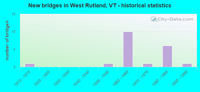
- New bridges - historical statistics
- 11910-1919
- 11950-1959
- 101960-1969
- 11970-1979
- 61980-1989
- 11990-1999


- Bridge Condition - Deck
- 21.4%Very good
- 21.4%Good
- 28.6%Satisfactory
- 28.6%Fair

- Bridge Condition - Superstructure
- 21.4%Very good
- 71.4%Good
- 7.1%Satisfactory

- Bridge Condition - Substructure
- 42.9%Good
- 50.0%Satisfactory
- 7.1%Fair

- Bridge Condition - Channel
- 62.5%Very good
- 12.5%Good
- 25.0%Satisfactory
Find on map >> Show street view
Structure Number: 101128001411281, Location: 0.1 MI TO JCT W VT133 (Lat: 43.574411, Lng: -73.032708), Route carried "on" structure: Other road C3017, Year Built: 1977, Status: Open, Structure Length: 1.25m (4.10ft), Average Daily Traffic: 30 (year 2019), Truck Traffic: 2%, Average Future Daily Traffic: 32 (year 2029), Design Load: H 20, Features Intersected: CLARENDON RIVER
Minimum Vertical Clearance: 30+ m (98+ ft), Kilometerpoint: 0.000, Lanes on structure: 1, Owner: Town or Township Highway Agency, Approaching Roadway Width: 4.3m (14.1ft), Material/Design: Steel, Design/Construction: Stringer/Multi-beam, Number Of Spans In Main Unit: 1, Length of Maximum Span: 11.9m (39.0ft), Curb or Sidewalk Widths: Left: 0.2m (0.7ft), Right: 0.2m (0.7ft), Curb-To-Curb Width: 3.7m (12.1ft), Out-to-Out Width: 4.5m (14.8ft)
Condition: Deck: Good, Superstructure: Good, Substructure: Good, Channel: Satisfactory, Operating Rating: 75.3 metric tons, Method Used To Determine Operating Rating: Allowable Stress (AS), Inventory Rating: 44.5 metric tons, Method Used To Determine Inventory Rating: Allowable Stress (AS), Structural Evaluation: Better than present minimum criteria, Deck Geometry: Meets minimum limits, Waterway Adequacy: Better than present minimum criteria, Approach Roadway Alignment: Equal to present desirable criteria, Length Of Structure Improvement: 1.25m (4.10ft), Designated Inspection Frequency: Every 24 months, Inspection Date: October 2020, Bridge Improvement Cost: $211,000, Roadway Improvement Cost: $50,000, Total Project Cost: $261,000 ( Estimate for 2020), Deck Structure Type: Concrete Cast-file-Place
Find on map >> Show street view
Structure Number: 101128001511281, Location: 0.05 MI TO JCT W VT4-A (Lat: 43.605703, Lng: -73.065153), Route carried "on" structure: Other road C3006, Year Built: 1919, Year Reconstructed: 1994, Status: Posted for load, Structure Length: 1.34m (4.40ft), Average Daily Traffic: 400 (year 2019), Truck Traffic: 2%, Average Future Daily Traffic: 420 (year 2029), Design Load: H 15, Features Intersected: CASTLETON RIVER, Facility Carried by Structure: C2004
Minimum Vertical Clearance: 30+ m (98+ ft), Kilometerpoint: 0.000, Lanes on structure: 2, Owner: Town or Township Highway Agency, Approaching Roadway Width: 7.9m (25.9ft), Skew: 1 degrees, Material/Design: Steel, Design/Construction: Stringer/Multi-beam, Number Of Spans In Main Unit: 1, Length of Maximum Span: 12.8m (42.0ft), Curb or Sidewalk Widths: Left: 0.2m (0.7ft), Right: 0.2m (0.7ft), Curb-To-Curb Width: 6.2m (20.3ft), Out-to-Out Width: 7.4m (24.3ft)
Condition: Deck: Fair, Superstructure: Satisfactory, Substructure: Good, Channel: Satisfactory, Operating Rating: 53.5 metric tons, Method Used To Determine Operating Rating: Allowable Stress (AS), Inventory Rating: 35.4 metric tons, Method Used To Determine Inventory Rating: Allowable Stress (AS), Structural Evaluation: Equal to present minimum criteria, Deck Geometry: Meets minimum limits, Waterway Adequacy: Better than present minimum criteria, Approach Roadway Alignment: Meets minimum limits, Length Of Structure Improvement: 1.34m (4.40ft), Designated Inspection Frequency: Every 24 months, Inspection Date: October 2020, Bridge Improvement Cost: $373,000, Roadway Improvement Cost: $50,000, Total Project Cost: $423,000 ( Estimate for 2020), Deck Structure Type: Wood or Timber, Wearing Surface/Protective System: Wearing Surface: Bituminous, Membrane: Preformed Fabric, Deck Protection: Internally Sealed
Find on map >> Show street view
Structure Number: 101128001611281, Location: 0.01 MI TO JCT W US4 (Lat: 43.593097, Lng: -73.033683), Route carried "on" structure: Other road C3005, Year Built: 1988, Status: Open, Structure Length: 1.52m (4.99ft), Average Daily Traffic: 75 (year 2019), Truck Traffic: 2%, Average Future Daily Traffic: 79 (year 2029), Design Load: HS 20, Features Intersected: CLARENDON RIVER
Minimum Vertical Clearance: 30+ m (98+ ft), Kilometerpoint: 0.000, Lanes on structure: 2, Owner: Town or Township Highway Agency, Approaching Roadway Width: 7.3m (24.0ft), Skew: 1 degrees, Material/Design: Steel, Design/Construction: Stringer/Multi-beam, Number Of Spans In Main Unit: 1, Length of Maximum Span: 14.6m (47.9ft), Curb or Sidewalk Widths: Left: 0.2m (0.7ft), Right: 0.2m (0.7ft), Curb-To-Curb Width: 7.3m (24.0ft), Out-to-Out Width: 7.6m (24.9ft)
Condition: Deck: Very good, Superstructure: Very good, Substructure: Good, Channel: Very good, Operating Rating: 49.9 metric tons, Method Used To Determine Operating Rating: Allowable Stress (AS), Inventory Rating: 37.2 metric tons, Method Used To Determine Inventory Rating: Allowable Stress (AS), Structural Evaluation: Better than present minimum criteria, Deck Geometry: Equal to present minimum criteria, Waterway Adequacy: Better than present minimum criteria, Approach Roadway Alignment: Equal to present desirable criteria, Designated Inspection Frequency: Every 24 months, Inspection Date: October 2020, Deck Structure Type: Concrete Cast-file-Place, Wearing Surface/Protective System: Wearing Surface: Bituminous, Membrane: Preformed Fabric, Deck Protection: Epoxy Coated Reinforcing
Find on map >> Show street view
Structure Number: 101128002611281, Location: 0.1 MI TO JCT W US4 (Lat: 43.587403, Lng: -73.039028), Route carried "on" structure: Other road C3005, Year Built: 1986, Status: Open, Structure Length: 1.25m (4.10ft), Average Daily Traffic: 100 (year 2019), Truck Traffic: 2%, Average Future Daily Traffic: 105 (year 2029), Design Load: HS 20, Features Intersected: CLARENDON RIVER
Minimum Vertical Clearance: 30+ m (98+ ft), Kilometerpoint: 0.000, Lanes on structure: 2, Owner: Town or Township Highway Agency, Approaching Roadway Width: 9.1m (29.9ft), Material/Design: Concrete, Design/Construction: Slab, Number Of Spans In Main Unit: 1, Length of Maximum Span: 11.9m (39.0ft), Curb or Sidewalk Widths: Left: 0.1m (0.3ft), Right: 0.1m (0.3ft), Curb-To-Curb Width: 6.9m (22.6ft), Out-to-Out Width: 7.7m (25.3ft)
Condition: Deck: Very good, Superstructure: Very good, Substructure: Good, Channel: Very good, Operating Rating: 89.8 metric tons, Method Used To Determine Operating Rating: Load Factor (LF), Inventory Rating: 65.3 metric tons, Method Used To Determine Inventory Rating: Load Factor (LF), Structural Evaluation: Better than present minimum criteria, Deck Geometry: Somewhat better than minimum adequacy, Waterway Adequacy: Equal to present desirable criteria, Approach Roadway Alignment: Equal to present desirable criteria, Designated Inspection Frequency: Every 24 months, Inspection Date: October 2020, Deck Structure Type: Concrete Cast-file-Place, Wearing Surface/Protective System: Wearing Surface: Bituminous, Membrane: Preformed Fabric
Find on map >> Show street view
Structure Number: 103408001311282, Location: 0.2 MI TO JCT W CL3 TH6 (Lat: 43.610558, Lng: -73.058092), Route carried "on" structure: City street WATER, Year Built: 1992, Status: Posted for load, Structure Length: 0.85m (2.79ft), Average Daily Traffic: 60 (year 2016), Truck Traffic: 2%, Average Future Daily Traffic: 63 (year 2026), Design Load: HS 20, Features Intersected: CASTLETON RIVER
Minimum Vertical Clearance: 30+ m (98+ ft), Kilometerpoint: 0.000, Lanes on structure: 1, Owner: Town or Township Highway Agency, Approaching Roadway Width: 8.2m (26.9ft), Material/Design: Wood or Timber, Design/Construction: Slab, Number Of Spans In Main Unit: 1, Length of Maximum Span: 7.9m (25.9ft), Curb-To-Curb Width: 4.8m (15.7ft), Out-to-Out Width: 5.4m (17.7ft)
Condition: Deck: Very good, Superstructure: Very good, Substructure: Fair, Channel: Very good, Operating Rating: 41.7 metric tons, Method Used To Determine Operating Rating: Allowable Stress (AS), Inventory Rating: 29.0 metric tons, Method Used To Determine Inventory Rating: Allowable Stress (AS), Structural Evaluation: Somewhat better than minimum adequacy, Deck Geometry: Equal to present desirable criteria, Waterway Adequacy: Somewhat better than minimum adequacy, Approach Roadway Alignment: Equal to present desirable criteria, Length Of Structure Improvement: 0.85m (2.79ft), Designated Inspection Frequency: Every 24 months, Inspection Date: October 2020, Bridge Improvement Cost: $172,000, Roadway Improvement Cost: $50,000, Total Project Cost: $223,000 ( Estimate for 2020), Deck Structure Type: Aluminum, Wearing Surface/Protective System: Wearing Surface: Bituminous, Membrane: Preformed Fabric, Deck Protection: Internally Sealed
Find on map >> Show street view
Structure Number: 200020013E11282, Location: 2.3 MI W EXIT 6 VT.4A (Lat: 43.605303, Lng: -73.066603), Route carried "on" structure: US 4, Year Built: 1968, Status: Open, Structure Length: 12.50m (41.01ft), Average Daily Traffic: 13,400 (year 2018), Truck Traffic: 10%, Average Future Daily Traffic: 14,070 (year 2028), Design Load: HS 20, Features Intersected: CLARENDON PITTSFORD R.R.
Minimum Vertical Clearance: 30+ m (98+ ft), Kilometerpoint: 39.657, Lanes on structure: 2, Base Highway Network: Yes, Owner: State Highway Agency, Approaching Roadway Width: 10.4m (34.1ft), Material/Design: Steel, Design/Construction: Stringer/Multi-beam, Number Of Spans In Main Unit: 5, Length of Maximum Span: 26.8m (87.9ft), Curb or Sidewalk Widths: Left: 0.5m (1.6ft), Right: 0.5m (1.6ft), Curb-To-Curb Width: 9.3m (30.5ft), Out-to-Out Width: 10.9m (35.8ft)
Condition: Deck: Satisfactory, Superstructure: Good, Substructure: Satisfactory, Channel: Very good, Operating Rating: 85.3 metric tons, Method Used To Determine Operating Rating: Load Factor (LF), Inventory Rating: 50.8 metric tons, Method Used To Determine Inventory Rating: Load Factor (LF), Structural Evaluation: Equal to present minimum criteria, Deck Geometry: Meets minimum limits, Underclear: Somewhat better than minimum adequacy, Waterway Adequacy: Equal to present desirable criteria, Approach Roadway Alignment: Equal to present desirable criteria, Length Of Structure Improvement: 12.50m (41.01ft), Designated Inspection Frequency: Every 24 months, Inspection Date: May 2021, Bridge Improvement Cost: $5,109,000, Roadway Improvement Cost: $50,000, Total Project Cost: $5,159,000 ( Estimate for 2020), Deck Structure Type: Concrete Cast-file-Place, Wearing Surface/Protective System: Wearing Surface: Bituminous, Membrane: Preformed Fabric
Find on map >> Show street view
Structure Number: 200020013W11282, Location: 2.3 MI W EXIT 6 VT.4A (Lat: 43.605403, Lng: -73.066317), Route carried "on" structure: US 4, Year Built: 1968, Status: Open, Structure Length: 9.60m (31.50ft), Average Daily Traffic: 13,400 (year 2018), Truck Traffic: 10%, Average Future Daily Traffic: 14,070 (year 2028), Design Load: HS 20, Features Intersected: CLARENDON PITTSFORD R.R.
Minimum Vertical Clearance: 30+ m (98+ ft), Kilometerpoint: 39.657, Lanes on structure: 2, Base Highway Network: Yes, Owner: State Highway Agency, Approaching Roadway Width: 10.4m (34.1ft), Material/Design: Steel, Design/Construction: Stringer/Multi-beam, Number Of Spans In Main Unit: 5, Length of Maximum Span: 29.3m (96.1ft), Curb or Sidewalk Widths: Left: 0.5m (1.6ft), Right: 0.5m (1.6ft), Curb-To-Curb Width: 9.3m (30.5ft), Out-to-Out Width: 10.9m (35.8ft)
Condition: Deck: Fair, Superstructure: Good, Substructure: Satisfactory, Channel: Very good, Operating Rating: 89.8 metric tons, Method Used To Determine Operating Rating: Load Factor (LF), Inventory Rating: 55.3 metric tons, Method Used To Determine Inventory Rating: Load Factor (LF), Structural Evaluation: Equal to present minimum criteria, Deck Geometry: Meets minimum limits, Underclear: Somewhat better than minimum adequacy, Waterway Adequacy: Equal to present desirable criteria, Approach Roadway Alignment: Equal to present desirable criteria, Length Of Structure Improvement: 9.60m (31.50ft), Designated Inspection Frequency: Every 24 months, Inspection Date: May 2021, Bridge Improvement Cost: $3,925,000, Roadway Improvement Cost: $50,000, Total Project Cost: $3,975,000 ( Estimate for 2020), Deck Structure Type: Concrete Cast-file-Place, Wearing Surface/Protective System: Wearing Surface: Bituminous, Membrane: Preformed Fabric
Find on map >> Show street view
Structure Number: 200020014E11282, Location: 2.1 MI W EXIT 6 VT.4A (Lat: 43.604372, Lng: -73.065108), Route carried "on" structure: US 4, Year Built: 1968, Status: Open, Structure Length: 8.96m (29.40ft), Average Daily Traffic: 13,400 (year 2018), Truck Traffic: 10%, Average Future Daily Traffic: 14,070 (year 2028), Design Load: HS 20, Features Intersected: US 4 OVER VT 4A
Minimum Vertical Clearance: 30+ m (98+ ft), Kilometerpoint: 39.850, Lanes on structure: 2, Lanes under structure: 2, Base Highway Network: Yes, Owner: State Highway Agency, Approaching Roadway Width: 10.1m (33.1ft), Skew: 4 degrees, Material/Design: Steel continuous, Design/Construction: Stringer/Multi-beam, Number Of Spans In Main Unit: 3, Length of Maximum Span: 36.0m (118.1ft), Curb or Sidewalk Widths: Left: 0.5m (1.6ft), Right: 0.5m (1.6ft), Curb-To-Curb Width: 9.1m (29.9ft), Out-to-Out Width: 10.8m (35.4ft)
Condition: Deck: Fair, Superstructure: Good, Substructure: Satisfactory, Operating Rating: 59.9 metric tons, Method Used To Determine Operating Rating: Load Factor (LF), Inventory Rating: 36.3 metric tons, Method Used To Determine Inventory Rating: Load Factor (LF), Structural Evaluation: Equal to present minimum criteria, Deck Geometry: Meets minimum limits, Underclear: Superior to present desirable criteria, Approach Roadway Alignment: Equal to present desirable criteria, Length Of Structure Improvement: 8.96m (29.40ft), Designated Inspection Frequency: Every 24 months, Inspection Date: May 2021, Bridge Improvement Cost: $3,653,000, Roadway Improvement Cost: $50,000, Total Project Cost: $3,703,000 ( Estimate for 2020), Deck Structure Type: Concrete Cast-file-Place, Wearing Surface/Protective System: Wearing Surface: Bituminous, Membrane: Preformed Fabric
Find on map >> Show street view
Structure Number: 200020014W11282, Location: 2.1 MI W EXIT 6 VT.4A (Lat: 43.604375, Lng: -73.064669), Route carried "on" structure: US 4, Year Built: 1968, Status: Open, Structure Length: 10.39m (34.09ft), Average Daily Traffic: 13,400 (year 2018), Truck Traffic: 10%, Average Future Daily Traffic: 14,070 (year 2028), Design Load: HS 20, Features Intersected: US 4 OVER VT 4A
Minimum Vertical Clearance: 30+ m (98+ ft), Kilometerpoint: 39.850, Lanes on structure: 2, Lanes under structure: 2, Base Highway Network: Yes, Owner: State Highway Agency, Approaching Roadway Width: 10.1m (33.1ft), Skew: 5 degrees, Material/Design: Steel continuous, Design/Construction: Stringer/Multi-beam, Number Of Spans In Main Unit: 3, Length of Maximum Span: 42.1m (138.1ft), Curb or Sidewalk Widths: Left: 0.5m (1.6ft), Right: 0.5m (1.6ft), Curb-To-Curb Width: 9.1m (29.9ft), Out-to-Out Width: 10.8m (35.4ft)
Condition: Deck: Fair, Superstructure: Good, Substructure: Satisfactory, Operating Rating: 57.2 metric tons, Method Used To Determine Operating Rating: Load Factor (LF), Inventory Rating: 33.6 metric tons, Method Used To Determine Inventory Rating: Load Factor (LF), Structural Evaluation: Equal to present minimum criteria, Deck Geometry: Meets minimum limits, Underclear: Better than present minimum criteria, Approach Roadway Alignment: Equal to present desirable criteria, Length Of Structure Improvement: 10.39m (34.09ft), Designated Inspection Frequency: Every 24 months, Inspection Date: May 2021, Bridge Improvement Cost: $4,237,000, Roadway Improvement Cost: $50,000, Total Project Cost: $4,287,000 ( Estimate for 2020), Deck Structure Type: Concrete Cast-file-Place, Wearing Surface/Protective System: Wearing Surface: Bituminous, Membrane: Preformed Fabric
Find on map >> Show street view
Structure Number: 200020015E11282, Location: 0.6 MI W EXIT 6 VT.4A (Lat: 43.587869, Lng: -73.045475), Route carried "on" structure: US 4, Year Built: 1968, Status: Open, Structure Length: 3.02m (9.91ft), Average Daily Traffic: 13,400 (year 2018), Truck Traffic: 10%, Average Future Daily Traffic: 14,070 (year 2028), Design Load: HS 20, Features Intersected: US 4 OVER VT 133
Minimum Vertical Clearance: 30+ m (98+ ft), Kilometerpoint: 42.328, Lanes on structure: 2, Lanes under structure: 2, Base Highway Network: Yes, Owner: State Highway Agency, Approaching Roadway Width: 11.6m (38.1ft), Skew: 2 degrees, Material/Design: Steel, Design/Construction: Stringer/Multi-beam, Number Of Spans In Main Unit: 1, Length of Maximum Span: 29.6m (97.1ft), Curb or Sidewalk Widths: Left: 0.2m (0.7ft), Right: 0.2m (0.7ft), Curb-To-Curb Width: 11.6m (38.1ft), Out-to-Out Width: 13.3m (43.6ft)
Condition: Deck: Satisfactory, Superstructure: Good, Substructure: Satisfactory, Operating Rating: 89.8 metric tons, Method Used To Determine Operating Rating: Load Factor (LF), Inventory Rating: 55.3 metric tons, Method Used To Determine Inventory Rating: Load Factor (LF), Structural Evaluation: Equal to present minimum criteria, Deck Geometry: Somewhat better than minimum adequacy, Underclear: Somewhat better than minimum adequacy, Approach Roadway Alignment: Equal to present desirable criteria, Designated Inspection Frequency: Every 24 months, Inspection Date: May 2021, Deck Structure Type: Concrete Cast-file-Place, Wearing Surface/Protective System: Wearing Surface: Bituminous, Membrane: Preformed Fabric
Find on map >> Show street view
Structure Number: 200020015W11282, Location: 0.6 MI W EXIT 6 VT.4A (Lat: 43.588100, Lng: -73.045492), Route carried "on" structure: US 4, Year Built: 1968, Status: Open, Structure Length: 3.02m (9.91ft), Average Daily Traffic: 13,400 (year 2018), Truck Traffic: 10%, Average Future Daily Traffic: 14,070 (year 2028), Design Load: HS 20, Features Intersected: US 4 OVER VT133
Minimum Vertical Clearance: 30+ m (98+ ft), Kilometerpoint: 42.183, Lanes on structure: 2, Lanes under structure: 2, Base Highway Network: Yes, Owner: State Highway Agency, Approaching Roadway Width: 11.6m (38.1ft), Skew: 2 degrees, Material/Design: Steel, Design/Construction: Stringer/Multi-beam, Number Of Spans In Main Unit: 1, Length of Maximum Span: 29.6m (97.1ft), Curb or Sidewalk Widths: Left: 0.2m (0.7ft), Right: 0.2m (0.7ft), Curb-To-Curb Width: 11.6m (38.1ft), Out-to-Out Width: 13.3m (43.6ft)
Condition: Deck: Satisfactory, Superstructure: Good, Substructure: Satisfactory, Operating Rating: 89.8 metric tons, Method Used To Determine Operating Rating: Load Factor (LF), Inventory Rating: 55.3 metric tons, Method Used To Determine Inventory Rating: Load Factor (LF), Structural Evaluation: Equal to present minimum criteria, Deck Geometry: Somewhat better than minimum adequacy, Underclear: Meets minimum limits, Approach Roadway Alignment: Equal to present desirable criteria, Designated Inspection Frequency: Every 24 months, Inspection Date: May 2021, Deck Structure Type: Concrete Cast-file-Place, Wearing Surface/Protective System: Wearing Surface: Bituminous, Membrane: Preformed Fabric
Find on map >> Show street view
Structure Number: 200020016E11282, Location: US 4 EXIT 6 (Lat: 43.588367, Lng: -73.039836), Route carried "on" structure: US 4, Year Built: 1986, Status: Open, Structure Length: 5.06m (16.60ft), Average Daily Traffic: 13,400 (year 2018), Truck Traffic: 10%, Average Future Daily Traffic: 14,070 (year 2028), Design Load: HS 20+Mod, Features Intersected: US 4 OVER BR US 4
Minimum Vertical Clearance: 30+ m (98+ ft), Kilometerpoint: 42.795, Lanes on structure: 2, Lanes under structure: 2, Base Highway Network: Yes, Owner: State Highway Agency, Approaching Roadway Width: 11.6m (38.1ft), Material/Design: Steel continuous, Design/Construction: Stringer/Multi-beam, Number Of Spans In Main Unit: 3, Length of Maximum Span: 36.6m (120.1ft), Curb or Sidewalk Widths: Left: 0.2m (0.7ft), Right: 0.2m (0.7ft), Curb-To-Curb Width: 11.3m (37.1ft), Out-to-Out Width: 12.4m (40.7ft)
Condition: Deck: Good, Superstructure: Good, Substructure: Good, Operating Rating: 78.9 metric tons, Method Used To Determine Operating Rating: Allowable Stress (AS), Inventory Rating: 45.4 metric tons, Method Used To Determine Inventory Rating: Allowable Stress (AS), Structural Evaluation: Better than present minimum criteria, Deck Geometry: Meets minimum limits, Underclear: Equal to present minimum criteria, Approach Roadway Alignment: Equal to present desirable criteria, Designated Inspection Frequency: Every 24 months, Inspection Date: May 2021, Deck Structure Type: Concrete Cast-file-Place, Wearing Surface/Protective System: Wearing Surface: Bituminous, Membrane: Preformed Fabric
Find on map >> Show street view
Structure Number: 200020016W11282, Location: US 4 EXIT 6 (Lat: 43.588611, Lng: -73.039911), Route carried "on" structure: US 4, Year Built: 1986, Status: Open, Structure Length: 5.06m (16.60ft), Average Daily Traffic: 13,400 (year 2018), Truck Traffic: 10%, Average Future Daily Traffic: 14,070 (year 2028), Design Load: HS 20+Mod, Features Intersected: US 4 OVER BR US 4
Minimum Vertical Clearance: 30+ m (98+ ft), Kilometerpoint: 42.795, Lanes on structure: 2, Lanes under structure: 2, Base Highway Network: Yes, Owner: State Highway Agency, Approaching Roadway Width: 11.6m (38.1ft), Material/Design: Steel continuous, Design/Construction: Stringer/Multi-beam, Number Of Spans In Main Unit: 3, Length of Maximum Span: 36.6m (120.1ft), Curb or Sidewalk Widths: Left: 0.2m (0.7ft), Right: 0.2m (0.7ft), Curb-To-Curb Width: 11.3m (37.1ft), Out-to-Out Width: 12.4m (40.7ft)
Condition: Deck: Good, Superstructure: Good, Substructure: Good, Operating Rating: 78.9 metric tons, Method Used To Determine Operating Rating: Allowable Stress (AS), Inventory Rating: 45.4 metric tons, Method Used To Determine Inventory Rating: Allowable Stress (AS), Structural Evaluation: Better than present minimum criteria, Deck Geometry: Meets minimum limits, Underclear: Equal to present minimum criteria, Approach Roadway Alignment: Equal to present desirable criteria, Designated Inspection Frequency: Every 24 months, Inspection Date: May 2021, Deck Structure Type: Concrete Cast-file-Place, Wearing Surface/Protective System: Wearing Surface: Bituminous, Membrane: Preformed Fabric
Find on map >> Show street view
Structure Number: 203200B4-311202, Location: 0.5 MI W JCT. VT.3 (Lat: 43.600883, Lng: -73.018778), Route carried "on" structure: Business US BR4, Year Built: 1959, Status: Open, Structure Length: 3.54m (11.61ft), Average Daily Traffic: 12,200 (year 2018), Truck Traffic: 11%, Average Future Daily Traffic: 12,810 (year 2028), Design Load: HS 20, Features Intersected: CLARENDON RIVER
Minimum Vertical Clearance: 30+ m (98+ ft), Kilometerpoint: 3.327, Lanes on structure: 4, Base Highway Network: Yes, Owner: State Highway Agency, Approaching Roadway Width: 20.1m (65.9ft), Skew: 3 degrees, Material/Design: Steel, Design/Construction: Stringer/Multi-beam, Number Of Spans In Main Unit: 1, Length of Maximum Span: 33.5m (109.9ft), Curb or Sidewalk Widths: Left: 1.5m (4.9ft), Right: 1.5m (4.9ft), Curb-To-Curb Width: 17.0m (55.8ft), Out-to-Out Width: 20.8m (68.2ft)
Condition: Deck: Satisfactory, Superstructure: Good, Substructure: Satisfactory, Channel: Good, Operating Rating: 89.8 metric tons, Method Used To Determine Operating Rating: Load Factor (LF), Inventory Rating: 60.8 metric tons, Method Used To Determine Inventory Rating: Load Factor (LF), Structural Evaluation: Equal to present minimum criteria, Deck Geometry: Somewhat better than minimum adequacy, Waterway Adequacy: Equal to present minimum criteria, Approach Roadway Alignment: Equal to present desirable criteria, Length Of Structure Improvement: 3.54m (11.61ft), Designated Inspection Frequency: Every 24 months, Inspection Date: May 2021, Bridge Improvement Cost: $2,773,000, Roadway Improvement Cost: $50,000, Total Project Cost: $2,823,000 ( Estimate for 2020), Deck Structure Type: Concrete Cast-file-Place, Wearing Surface/Protective System: Wearing Surface: Bituminous
Find on map >> Show street view
Structure Number: 200020014E11282, Location: 2.1 MI W EXIT 6 VT.4A (Lat: 43.604372, Lng: -73.065108), Route carried "under" structure: Alternate State highway 4A, Year Built: 1968, Structure Length: 0. m, Average Daily Traffic: 2,000 (year 1998), Truck Traffic: 6%, Features Intersected: US 4 OVER VT 4A, Facility Carried by Structure: US 00004 ML
Minimum Vertical Clearance: 5.48m (17.98ft), Kilometerpoint: 0.000, Lanes on structure: 2, Material/Design: Steel continuous, Design/Construction: Stringer/Multi-beam, Length of Maximum Span: 36.0m (118.1ft)
Find on map >> Show street view
Structure Number: 200020014W11282, Location: 2.1 MI W EXIT 6 VT.4A (Lat: 43.604375, Lng: -73.064669), Route carried "under" structure: Alternate State highway 4A, Year Built: 1968, Structure Length: 0. m, Average Daily Traffic: 2,000 (year 1998), Truck Traffic: 6%, Features Intersected: US 4 OVER VT 4A, Facility Carried by Structure: US 00004 ML
Minimum Vertical Clearance: 5.68m (18.64ft), Kilometerpoint: 0.000, Lanes on structure: 2, Material/Design: Steel continuous, Design/Construction: Stringer/Multi-beam, Length of Maximum Span: 36.0m (118.1ft)
Find on map >> Show street view
Structure Number: 200020015E11282, Location: 0.6 MI W EXIT 6 VT.4A (Lat: 43.587869, Lng: -73.045475), Route carried "under" structure: State highway 133, Year Built: 1968, Structure Length: 0. m, Average Daily Traffic: 4,100 (year 1998), Truck Traffic: 6%, Features Intersected: US 4 OVER VT 133, Facility Carried by Structure: US 00004 ML
Minimum Vertical Clearance: 5.20m (17.06ft), Kilometerpoint: 0.000, Lanes on structure: 4, Material/Design: Steel, Design/Construction: Stringer/Multi-beam, Length of Maximum Span: 29.6m (97.1ft)
Find on map >> Show street view
Structure Number: 200020015W11282, Location: 0.6 MI W EXIT 6 VT.4A (Lat: 43.588100, Lng: -73.045492), Route carried "under" structure: State highway 133, Year Built: 1968, Structure Length: 0. m, Average Daily Traffic: 4,100 (year 1998), Truck Traffic: 6%, Features Intersected: US 4 OVER VT 133, Facility Carried by Structure: US 00004 ML
Minimum Vertical Clearance: 4.34m (14.24ft), Kilometerpoint: 0.000, Lanes on structure: 4, Material/Design: Steel, Design/Construction: Stringer/Multi-beam, Length of Maximum Span: 29.6m (97.1ft)
Find on map >> Show street view
Structure Number: 200020016E11282, Location: US 4 EXIT 6 (Lat: 43.588367, Lng: -73.039836), Route carried "under" structure: Business US BR4, Year Built: 1986, Structure Length: 0. m, Average Daily Traffic: 4,200 (year 1998), Truck Traffic: 10%, Features Intersected: US 4 OVER BR US 4, Facility Carried by Structure: US 00004 ML
Minimum Vertical Clearance: 4.49m (14.73ft), Kilometerpoint: 0.080, Lanes on structure: 2, Material/Design: Steel continuous, Design/Construction: Stringer/Multi-beam, Length of Maximum Span: 36.6m (120.1ft)
Find on map >> Show street view
Structure Number: 200020016W11282, Location: US 4 EXIT 6 (Lat: 43.588611, Lng: -73.039911), Route carried "under" structure: Business US BR4, Year Built: 1986, Structure Length: 0. m, Average Daily Traffic: 4,200 (year 1998), Truck Traffic: 10%, Features Intersected: US 4 OVER BR US 4, Facility Carried by Structure: US 00004 ML
Minimum Vertical Clearance: 4.77m (15.65ft), Kilometerpoint: 0.080, Lanes on structure: 2, Material/Design: Steel continuous, Design/Construction: Stringer/Multi-beam, Length of Maximum Span: 36.6m (120.1ft)