Bridge Statistics for West Union, Ohio (OH)
Condition, Traffic, Stress, Structural Evaluation, Project Costs
- National Bridge Inventory (NBI) Statistics
- 19Number of bridges
- 125ft / 38.0mTotal length
- 28,105Total average daily traffic
- 1,964Total average daily truck traffic
- 39,008Total future (year 2035) average daily traffic
- National Bridge Inventory (NBI) Registered Bridges for West Union
- No street view available for this location
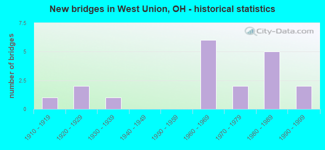
- New bridges - historical statistics
- 11910-1919
- 21920-1929
- 11930-1939
- 61960-1969
- 21970-1979
- 51980-1989
- 21990-1999

- Reconstructed bridges - Historical Statistics
- 31980-1989
- 11990-1999


- Bridge Condition - Deck
- 5.3%Excellent
- 5.3%Very good
- 15.8%Good
- 47.4%Satisfactory
- 21.1%Fair
- 5.3%Poor

- Bridge Condition - Superstructure
- 5.3%Excellent
- 5.3%Very good
- 10.5%Good
- 42.1%Satisfactory
- 31.6%Fair
- 5.3%Poor

- Bridge Condition - Substructure
- 15.8%Very good
- 10.5%Good
- 47.4%Satisfactory
- 26.3%Fair

- Bridge Condition - Channel
- 15.8%Very good
- 26.3%Good
- 42.1%Satisfactory
- 10.5%Fair
- 5.3%Poor
Find on map >> Show street view
Structure Number: 101001, Location: .27 MI S OF WEST UNION (Lat: 38.775311, Lng: -83.573161), Route carried "on" structure: State highway 41, Year Built: 1985, Status: Open, Structure Length: 2.32m (7.61ft), Average Daily Traffic: 5,812 (year 2015), Truck Traffic: 6%, Average Future Daily Traffic: 8,067 (year 2035), Design Load: HS 20, Features Intersected: AUSTRALIS RUN
Minimum Vertical Clearance: 30+ m (98+ ft), Kilometerpoint: 17.043, Lanes on structure: 2, Base Highway Network: Yes, Owner: State Highway Agency, Approaching Roadway Width: 6.7m (22.0ft), Skew: 1 degrees, Material/Design: Prestressed concrete, Design/Construction: Box Beam or Girders - Multiple, Number Of Spans In Main Unit: 1, Length of Maximum Span: 22.9m (75.1ft), Curb-To-Curb Width: 9.1m (29.9ft), Out-to-Out Width: 9.1m (29.9ft)
Condition: Deck: Fair, Superstructure: Fair, Substructure: Good, Channel: Good, Operating Rating: 42.1 metric tons, Method Used To Determine Operating Rating: Allowable Stress (AS) rating reported by rating factor (RF) method using MS18 loading, Inventory Rating: 32.4 metric tons, Method Used To Determine Inventory Rating: Allowable Stress (AS) rating reported by rating factor (RF) method using MS18 loading, Structural Evaluation: Somewhat better than minimum adequacy, Deck Geometry: High priority of corrective action, Waterway Adequacy: Better than present minimum criteria, Approach Roadway Alignment: Better than present minimum criteria, Designated Inspection Frequency: Every 12 months, Inspection Date: January 2022, Deck Structure Type: Concrete Cast-file-Place, Wearing Surface/Protective System: Wearing Surface: Bituminous, Membrane: Preformed Fabric
Find on map >> Show street view
Structure Number: 101052, Location: 1.94 MI N OF WEST UNION (Lat: 38.818969, Lng: -83.513281), Route carried "on" structure: State highway 41, Year Built: 1967, Status: Open, Structure Length: 3.41m (11.19ft), Average Daily Traffic: 3,612 (year 2015), Truck Traffic: 8%, Average Future Daily Traffic: 5,013 (year 2035), Design Load: H 15, Features Intersected: EAST LICK FORK CREEK
Minimum Vertical Clearance: 30+ m (98+ ft), Kilometerpoint: 24.639, Lanes on structure: 2, Base Highway Network: Yes, Owner: State Highway Agency, Approaching Roadway Width: 13.4m (44.0ft), Skew: 1 degrees, Material/Design: Concrete continuous, Design/Construction: Slab, Number Of Spans In Main Unit: 3, Length of Maximum Span: 12.5m (41.0ft), Curb-To-Curb Width: 13.4m (44.0ft), Out-to-Out Width: 13.4m (44.0ft)
Condition: Deck: Satisfactory, Superstructure: Satisfactory, Substructure: Satisfactory, Channel: Very good, Operating Rating: 38.9 metric tons, Method Used To Determine Operating Rating: Load Factor (LF) rating reported by rating factor (RF) method using MS18 loading, Inventory Rating: 22.7 metric tons, Method Used To Determine Inventory Rating: Load Factor (LF) rating reported by rating factor (RF) method using MS18 loading, Structural Evaluation: Equal to present minimum criteria, Deck Geometry: Better than present minimum criteria, Waterway Adequacy: Equal to present desirable criteria, Approach Roadway Alignment: Equal to present desirable criteria, Designated Inspection Frequency: Every 12 months, Inspection Date: March 2021, Deck Structure Type: Concrete Cast-file-Place, Wearing Surface/Protective System: Wearing Surface: Bituminous
Find on map >> Show street view
Structure Number: 101087, Location: 3.10 MI N. OF WEST UNION (Lat: 38.832650, Lng: -83.502511), Route carried "on" structure: State highway 41, Year Built: 1967, Status: Posted for load, Structure Length: 3.23m (10.60ft), Average Daily Traffic: 3,612 (year 2015), Truck Traffic: 8%, Average Future Daily Traffic: 5,013 (year 2035), Design Load: H 15, Features Intersected: W BR LICK FK OH BRUSH CR
Minimum Vertical Clearance: 30+ m (98+ ft), Kilometerpoint: 26.506, Lanes on structure: 2, Base Highway Network: Yes, Owner: State Highway Agency, Approaching Roadway Width: 9.8m (32.2ft), Skew: 3 degrees, Material/Design: Concrete continuous, Design/Construction: Slab, Number Of Spans In Main Unit: 3, Length of Maximum Span: 11.6m (38.1ft), Curb-To-Curb Width: 13.4m (44.0ft), Out-to-Out Width: 13.4m (44.0ft)
Condition: Deck: Satisfactory, Superstructure: Satisfactory, Substructure: Satisfactory, Channel: Satisfactory, Operating Rating: 38.9 metric tons, Method Used To Determine Operating Rating: Load Factor (LF) rating reported by rating factor (RF) method using MS18 loading, Inventory Rating: 22.7 metric tons, Method Used To Determine Inventory Rating: Load Factor (LF) rating reported by rating factor (RF) method using MS18 loading, Structural Evaluation: Equal to present minimum criteria, Deck Geometry: Better than present minimum criteria, Waterway Adequacy: Better than present minimum criteria, Approach Roadway Alignment: Better than present minimum criteria, Bridge Posting: Required (Relationship of Operating Rating to Maximum Legal Load: 0.1 - 9.9% below), Designated Inspection Frequency: Every 12 months, Inspection Date: March 2021, Deck Structure Type: Concrete Cast-file-Place, Wearing Surface/Protective System: Wearing Surface: Bituminous
Find on map >> Show street view
Structure Number: 101141, Location: 4.96 MI N OF WEST UNION (Lat: 38.850711, Lng: -83.482631), Route carried "on" structure: State highway 41, Year Built: 1961, Status: Open, Structure Length: 3.54m (11.61ft), Average Daily Traffic: 3,612 (year 2015), Truck Traffic: 8%, Average Future Daily Traffic: 5,013 (year 2035), Design Load: H 15, Features Intersected: TREBER RUN
Minimum Vertical Clearance: 30+ m (98+ ft), Kilometerpoint: 29.499, Lanes on structure: 2, Base Highway Network: Yes, Owner: State Highway Agency, Approaching Roadway Width: 8.5m (27.9ft), Skew: 3 degrees, Material/Design: Concrete continuous, Design/Construction: Slab, Number Of Spans In Main Unit: 3, Length of Maximum Span: 13.1m (43.0ft), Curb-To-Curb Width: 12.1m (39.7ft), Out-to-Out Width: 12.1m (39.7ft)
Condition: Deck: Fair, Superstructure: Fair, Substructure: Fair, Channel: Good, Operating Rating: 48.6 metric tons, Method Used To Determine Operating Rating: Load Factor (LF) rating reported by rating factor (RF) method using MS18 loading, Inventory Rating: 29.2 metric tons, Method Used To Determine Inventory Rating: Load Factor (LF) rating reported by rating factor (RF) method using MS18 loading, Structural Evaluation: Somewhat better than minimum adequacy, Deck Geometry: Somewhat better than minimum adequacy, Waterway Adequacy: Better than present minimum criteria, Approach Roadway Alignment: Better than present minimum criteria, Designated Inspection Frequency: Every 12 months, Inspection Date: March 2021, Deck Structure Type: Concrete Cast-file-Place, Wearing Surface/Protective System: Wearing Surface: Bituminous
Find on map >> Show street view
Structure Number: 103063, Location: 1.64 MI E OF SR 136 (Lat: 38.808111, Lng: -83.576289), Route carried "on" structure: State highway 125, Year Built: 1964, Status: Open, Structure Length: 2.44m (8.01ft), Average Daily Traffic: 2,980 (year 2015), Truck Traffic: 6%, Average Future Daily Traffic: 4,136 (year 2035), Design Load: H 15, Features Intersected: EAST FORK OF EAGLE CREEK
Minimum Vertical Clearance: 30+ m (98+ ft), Kilometerpoint: 10.525, Lanes on structure: 2, Owner: State Highway Agency, Approaching Roadway Width: 9.1m (29.9ft), Skew: 3 degrees, Material/Design: Concrete continuous, Design/Construction: Slab, Number Of Spans In Main Unit: 3, Length of Maximum Span: 8.5m (27.9ft), Curb-To-Curb Width: 11.0m (36.1ft), Out-to-Out Width: 11.0m (36.1ft)
Condition: Deck: Satisfactory, Superstructure: Satisfactory, Substructure: Satisfactory, Channel: Satisfactory, Operating Rating: 45.4 metric tons, Method Used To Determine Operating Rating: Load Factor (LF) rating reported by rating factor (RF) method using MS18 loading, Inventory Rating: 25.9 metric tons, Method Used To Determine Inventory Rating: Load Factor (LF) rating reported by rating factor (RF) method using MS18 loading, Structural Evaluation: Equal to present minimum criteria, Deck Geometry: Somewhat better than minimum adequacy, Waterway Adequacy: Equal to present desirable criteria, Approach Roadway Alignment: Equal to present minimum criteria, Designated Inspection Frequency: Every 12 months, Inspection Date: Febuary 2022, Deck Structure Type: Concrete Cast-file-Place, Wearing Surface/Protective System: Wearing Surface: Bituminous
Find on map >> Show street view
Structure Number: 103683, Location: 2.9 MI N OF JCT US 52 (Lat: 38.746419, Lng: -83.518061), Route carried "on" structure: State highway 247, Year Built: 1984, Status: Open, Structure Length: 2.19m (7.19ft), Average Daily Traffic: 673 (year 2015), Truck Traffic: 7%, Average Future Daily Traffic: 934 (year 2035), Design Load: HS 20+Mod, Features Intersected: MOORES RUN
Minimum Vertical Clearance: 30+ m (98+ ft), Kilometerpoint: 5.311, Lanes on structure: 2, Owner: State Highway Agency, Approaching Roadway Width: 7.3m (24.0ft), Material/Design: Concrete continuous, Design/Construction: Slab, Number Of Spans In Main Unit: 2, Length of Maximum Span: 10.7m (35.1ft), Curb-To-Curb Width: 8.5m (27.9ft), Out-to-Out Width: 8.5m (27.9ft)
Condition: Deck: Fair, Superstructure: Fair, Substructure: Fair, Channel: Fair, Operating Rating: 97.2 metric tons, Method Used To Determine Operating Rating: Load Factor (LF) rating reported by rating factor (RF) method using MS18 loading, Inventory Rating: 84.2 metric tons, Method Used To Determine Inventory Rating: Load Factor (LF) rating reported by rating factor (RF) method using MS18 loading, Structural Evaluation: Somewhat better than minimum adequacy, Deck Geometry: Somewhat better than minimum adequacy, Waterway Adequacy: Equal to present desirable criteria, Approach Roadway Alignment: Meets minimum limits, Designated Inspection Frequency: Every 12 months, Inspection Date: March 2021, Deck Structure Type: Concrete Cast-file-Place, Wearing Surface/Protective System: Wearing Surface: Monolithic Concrete
Find on map >> Show street view
Structure Number: 103713, Location: 3.2 MI N OF JCT US 52 (Lat: 38.749061, Lng: -83.515881), Route carried "on" structure: State highway 247, Year Built: 1984, Status: Posted for load, Structure Length: 3.26m (10.70ft), Average Daily Traffic: 673 (year 2015), Truck Traffic: 7%, Average Future Daily Traffic: 934 (year 2035), Design Load: HS 20+Mod, Features Intersected: BEASLEY FK OF BRUSH CREE
Minimum Vertical Clearance: 30+ m (98+ ft), Kilometerpoint: 5.713, Lanes on structure: 2, Owner: State Highway Agency, Approaching Roadway Width: 7.9m (25.9ft), Skew: 3 degrees, Material/Design: Concrete continuous, Design/Construction: Slab, Number Of Spans In Main Unit: 3, Length of Maximum Span: 12.2m (40.0ft), Curb-To-Curb Width: 8.5m (27.9ft), Out-to-Out Width: 8.5m (27.9ft)
Condition: Deck: Fair, Superstructure: Fair, Substructure: Fair, Channel: Fair, Operating Rating: 29.2 metric tons, Method Used To Determine Operating Rating: Load Factor (LF) rating reported by rating factor (RF) method using MS18 loading, Inventory Rating: 19.4 metric tons, Method Used To Determine Inventory Rating: Load Factor (LF) rating reported by rating factor (RF) method using MS18 loading, Structural Evaluation: Somewhat better than minimum adequacy, Deck Geometry: Somewhat better than minimum adequacy, Waterway Adequacy: Equal to present desirable criteria, Approach Roadway Alignment: Somewhat better than minimum adequacy, Bridge Posting: Required (Relationship of Operating Rating to Maximum Legal Load: 10.0 - 19.9% below), Designated Inspection Frequency: Every 12 months, Inspection Date: March 2021, Deck Structure Type: Concrete Cast-file-Place, Wearing Surface/Protective System: Wearing Surface: Monolithic Concrete
Find on map >> Show street view
Structure Number: 103764, Location: 4.5 MI N OF JCT US 50 (Lat: 38.765819, Lng: -83.523250), Route carried "on" structure: State highway 247, Year Built: 1983, Status: Open, Structure Length: 3.26m (10.70ft), Average Daily Traffic: 673 (year 2015), Truck Traffic: 7%, Average Future Daily Traffic: 934 (year 2035), Design Load: HS 20, Features Intersected: E BR OF BEAS FK OH BRS C
Minimum Vertical Clearance: 30+ m (98+ ft), Kilometerpoint: 7.870, Lanes on structure: 2, Owner: State Highway Agency, Approaching Roadway Width: 7.9m (25.9ft), Skew: 2 degrees, Material/Design: Concrete continuous, Design/Construction: Slab, Number Of Spans In Main Unit: 3, Length of Maximum Span: 12.2m (40.0ft), Curb-To-Curb Width: 8.5m (27.9ft), Out-to-Out Width: 8.5m (27.9ft)
Condition: Deck: Satisfactory, Superstructure: Satisfactory, Substructure: Satisfactory, Channel: Satisfactory, Operating Rating: 42.1 metric tons, Method Used To Determine Operating Rating: Allowable Stress (AS) rating reported by rating factor (RF) method using MS18 loading, Inventory Rating: 32.4 metric tons, Method Used To Determine Inventory Rating: Allowable Stress (AS) rating reported by rating factor (RF) method using MS18 loading, Structural Evaluation: Equal to present minimum criteria, Deck Geometry: Somewhat better than minimum adequacy, Waterway Adequacy: Equal to present desirable criteria, Approach Roadway Alignment: Better than present minimum criteria, Designated Inspection Frequency: Every 12 months, Inspection Date: March 2021, Deck Structure Type: Concrete Cast-file-Place, Wearing Surface/Protective System: Wearing Surface: Monolithic Concrete
Find on map >> Show street view
Structure Number: 103845, Location: 2.74MI N OF WEST UNION (Lat: 38.838811, Lng: -83.553069), Route carried "on" structure: State highway 247, Year Built: 1962, Status: Open, Structure Length: 0.94m (3.08ft), Average Daily Traffic: 3,391 (year 2015), Truck Traffic: 6%, Average Future Daily Traffic: 4,707 (year 2035), Design Load: H 15, Features Intersected: N BR OF LICK FK OH BRS C
Minimum Vertical Clearance: 30+ m (98+ ft), Kilometerpoint: 17.140, Lanes on structure: 2, Owner: State Highway Agency, Approaching Roadway Width: 10.4m (34.1ft), Skew: 2 degrees, Material/Design: Concrete, Design/Construction: Slab, Number Of Spans In Main Unit: 1, Length of Maximum Span: 8.5m (27.9ft), Curb-To-Curb Width: 11.0m (36.1ft), Out-to-Out Width: 11.0m (36.1ft)
Condition: Deck: Satisfactory, Superstructure: Satisfactory, Substructure: Satisfactory, Channel: Satisfactory, Operating Rating: 35.6 metric tons, Method Used To Determine Operating Rating: Load and Resistance Factor Rating (LRFR) rating reported by rating factor(RF) method using HL-93 loadings, Inventory Rating: 25.9 metric tons, Method Used To Determine Inventory Rating: Load and Resistance Factor Rating (LRFR) rating reported by rating factor(RF) method using HL-93 loadings, Structural Evaluation: Equal to present minimum criteria, Deck Geometry: Somewhat better than minimum adequacy, Waterway Adequacy: Equal to present desirable criteria, Approach Roadway Alignment: Better than present minimum criteria, Designated Inspection Frequency: Every 12 months, Inspection Date: January 2021, Deck Structure Type: Concrete Cast-file-Place, Wearing Surface/Protective System: Wearing Surface: Bituminous
Find on map >> Show street view
Structure Number: 130001, Location: .5 MI NE OF JCT SR 136 (Lat: 38.814389, Lng: -83.577811), Route carried "on" structure: County highway T76A, Year Built: 1999, Status: Open, Structure Length: 0.70m (2.30ft), Average Daily Traffic: 296 (year 2015), Truck Traffic: 7%, Average Future Daily Traffic: 411 (year 2035), Design Load: H 20, Features Intersected: SPRING RUN, Facility Carried by Structure: ROSSELOT ROAD
Minimum Vertical Clearance: 30+ m (98+ ft), Kilometerpoint: 0.322, Lanes on structure: 2, Owner: County Highway Agency, Approaching Roadway Width: 9.1m (29.9ft), Skew: 3 degrees, Material/Design: Steel, Design/Construction: Stringer/Multi-beam, Number Of Spans In Main Unit: 1, Length of Maximum Span: 6.1m (20.0ft), Curb-To-Curb Width: 7.6m (24.9ft), Out-to-Out Width: 8.5m (27.9ft)
Condition: Deck: Good, Superstructure: Good, Substructure: Very good, Channel: Poor, Operating Rating: 42.1 metric tons, Method Used To Determine Operating Rating: Allowable Stress (AS) rating reported by rating factor (RF) method using MS18 loading, Inventory Rating: 32.4 metric tons, Method Used To Determine Inventory Rating: Allowable Stress (AS) rating reported by rating factor (RF) method using MS18 loading, Structural Evaluation: Better than present minimum criteria, Deck Geometry: Somewhat better than minimum adequacy, Waterway Adequacy: Better than present minimum criteria, Approach Roadway Alignment: Better than present minimum criteria, Designated Inspection Frequency: Every 24 months, Inspection Date: November 2020, Deck Structure Type: Corrugated Steel, Wearing Surface/Protective System: Wearing Surface: Bituminous
Find on map >> Show street view
Structure Number: 130125, Location: 1 MI NE OF JUST SR 125 (Lat: 38.814639, Lng: -83.574389), Route carried "on" structure: County highway T76A, Year Built: 1999, Status: Open, Structure Length: 1.25m (4.10ft), Average Daily Traffic: 296 (year 2015), Truck Traffic: 7%, Average Future Daily Traffic: 411 (year 2035), Design Load: H 20, Features Intersected: EAGLE CREEK, Facility Carried by Structure: ROSSELOTT ROAD
Minimum Vertical Clearance: 30+ m (98+ ft), Kilometerpoint: 0.623, Lanes on structure: 2, Owner: County Highway Agency, Approaching Roadway Width: 8.2m (26.9ft), Material/Design: Steel, Design/Construction: Stringer/Multi-beam, Number Of Spans In Main Unit: 1, Length of Maximum Span: 11.6m (38.1ft), Curb-To-Curb Width: 7.6m (24.9ft), Out-to-Out Width: 7.6m (24.9ft)
Condition: Deck: Good, Superstructure: Good, Substructure: Very good, Channel: Satisfactory, Operating Rating: 42.1 metric tons, Method Used To Determine Operating Rating: Allowable Stress (AS) rating reported by rating factor (RF) method using MS18 loading, Inventory Rating: 35.6 metric tons, Method Used To Determine Inventory Rating: Allowable Stress (AS) rating reported by rating factor (RF) method using MS18 loading, Structural Evaluation: Better than present minimum criteria, Deck Geometry: Somewhat better than minimum adequacy, Waterway Adequacy: Better than present minimum criteria, Approach Roadway Alignment: Better than present minimum criteria, Designated Inspection Frequency: Every 24 months, Inspection Date: November 2020, Deck Structure Type: Corrugated Steel, Wearing Surface/Protective System: Wearing Surface: Bituminous
Find on map >> Show street view
Structure Number: 130508, Location: 0.5 MI W OF JCT 41 (Lat: 38.813911, Lng: -83.518839), Route carried "on" structure: County highway C141A, Year Built: 1924, Status: Open, Structure Length: 1.34m (4.40ft), Average Daily Traffic: 385 (year 2015), Truck Traffic: 8%, Average Future Daily Traffic: 534 (year 2035), Design Load: HS 20, Features Intersected: LICK FORK, Facility Carried by Structure: LICK RUN RD.
Minimum Vertical Clearance: 30+ m (98+ ft), Kilometerpoint: 0.089, Lanes on structure: 2, Owner: County Highway Agency, Approaching Roadway Width: 6.1m (20.0ft), Material/Design: Concrete, Design/Construction: Tee Beam, Number Of Spans In Main Unit: 1, Length of Maximum Span: 12.2m (40.0ft), Curb-To-Curb Width: 5.5m (18.0ft), Out-to-Out Width: 6.0m (19.7ft)
Condition: Deck: Satisfactory, Superstructure: Fair, Substructure: Fair, Channel: Good, Operating Rating: 47.2 metric tons, Method Used To Determine Operating Rating: Field evaluation and documented engineering judgment, Inventory Rating: 32.7 metric tons, Method Used To Determine Inventory Rating: Field evaluation and documented engineering judgment, Structural Evaluation: Somewhat better than minimum adequacy, Deck Geometry: High priority of corrective action, Waterway Adequacy: Better than present minimum criteria, Approach Roadway Alignment: Better than present minimum criteria, Designated Inspection Frequency: Every 12 months, Inspection Date: November 2021, Deck Structure Type: Concrete Cast-file-Place, Wearing Surface/Protective System: Wearing Surface: Bituminous
Find on map >> Show street view
Structure Number: 130699, Location: 1.5 MI W OF JCT SR 247 (Lat: 38.739039, Lng: -83.542000), Route carried "on" structure: County highway T03G, Year Built: 1970, Year Reconstructed: 2021, Status: Open, Structure Length: 0.98m (3.22ft), Average Daily Traffic: 351 (year 2015), Truck Traffic: 7%, Average Future Daily Traffic: 487 (year 2035), Design Load: HS 20, Features Intersected: MOORES RUN, Facility Carried by Structure: MOORES RUN ROAD
Minimum Vertical Clearance: 30+ m (98+ ft), Kilometerpoint: 1.371, Lanes on structure: 2, Owner: County Highway Agency, Approaching Roadway Width: 4.9m (16.1ft), Material/Design: Steel, Design/Construction: Stringer/Multi-beam, Number Of Spans In Main Unit: 1, Length of Maximum Span: 8.5m (27.9ft), Curb-To-Curb Width: 6.7m (22.0ft), Out-to-Out Width: 6.7m (22.0ft)
Condition: Deck: Excellent, Superstructure: Excellent, Substructure: Good, Channel: Good, Operating Rating: 97.2 metric tons, Method Used To Determine Operating Rating: Allowable Stress (AS) rating reported by rating factor (RF) method using MS18 loading, Inventory Rating: 58.3 metric tons, Method Used To Determine Inventory Rating: Allowable Stress (AS) rating reported by rating factor (RF) method using MS18 loading, Structural Evaluation: Better than present minimum criteria, Deck Geometry: Meets minimum limits, Waterway Adequacy: Better than present minimum criteria, Approach Roadway Alignment: Better than present minimum criteria, Designated Inspection Frequency: Every 12 months, Inspection Date: November 2021, Deck Structure Type: Concrete Cast-file-Place, Wearing Surface/Protective System: Wearing Surface: Monolithic Concrete
Find on map >> Show street view
Structure Number: 13071, Location: 3.2 MI N OF JCT SR 52 (Lat: 38.734950, Lng: -83.562411), Route carried "on" structure: County highway C03F, Year Built: 1983, Status: Open, Structure Length: 1.55m (5.09ft), Average Daily Traffic: 546 (year 2015), Truck Traffic: 8%, Average Future Daily Traffic: 758 (year 2035), Design Load: H 20, Features Intersected: ISLAND CREEK, Facility Carried by Structure: ISLAND CREEK RD.
Minimum Vertical Clearance: 30+ m (98+ ft), Kilometerpoint: 5.018, Lanes on structure: 2, Owner: County Highway Agency, Approaching Roadway Width: 7.3m (24.0ft), Material/Design: Prestressed concrete, Design/Construction: Box Beam or Girders - Multiple, Number Of Spans In Main Unit: 1, Length of Maximum Span: 14.6m (47.9ft), Curb-To-Curb Width: 7.3m (24.0ft), Out-to-Out Width: 7.9m (25.9ft)
Condition: Deck: Very good, Superstructure: Very good, Substructure: Very good, Channel: Very good, Operating Rating: 37.2 metric tons, Method Used To Determine Operating Rating: Field evaluation and documented engineering judgment, Inventory Rating: 27.1 metric tons, Method Used To Determine Inventory Rating: Field evaluation and documented engineering judgment, Structural Evaluation: Equal to present minimum criteria, Deck Geometry: Meets minimum limits, Waterway Adequacy: Equal to present desirable criteria, Approach Roadway Alignment: Meets minimum limits, Designated Inspection Frequency: Every 24 months, Inspection Date: November 2021, Deck Structure Type: Concrete Cast-file-Place, Wearing Surface/Protective System: Wearing Surface: Bituminous
Find on map >> Show street view
Structure Number: 130869, Location: 0.182 MI NE OF JCTOFSR247 (Lat: 38.837311, Lng: -83.549589), Route carried "on" structure: County highway C10D, Year Built: 1935, Status: Open, Structure Length: 0.79m (2.59ft), Average Daily Traffic: 436 (year 2015), Truck Traffic: 8%, Average Future Daily Traffic: 605 (year 2035), Features Intersected: STREAM, Facility Carried by Structure: UNITY RD.
Minimum Vertical Clearance: 30+ m (98+ ft), Kilometerpoint: 0.293, Lanes on structure: 2, Owner: County Highway Agency, Approaching Roadway Width: 5.5m (18.0ft), Material/Design: Concrete, Design/Construction: Slab, Number Of Spans In Main Unit: 1, Length of Maximum Span: 6.7m (22.0ft), Curb-To-Curb Width: 6.1m (20.0ft), Out-to-Out Width: 6.7m (22.0ft)
Condition: Deck: Satisfactory, Superstructure: Satisfactory, Substructure: Satisfactory, Channel: Satisfactory, Operating Rating: 40.8 metric tons, Method Used To Determine Operating Rating: Field evaluation and documented engineering judgment, Inventory Rating: 32.7 metric tons, Method Used To Determine Inventory Rating: Field evaluation and documented engineering judgment, Structural Evaluation: Equal to present minimum criteria, Deck Geometry: High priority of corrective action, Waterway Adequacy: Better than present minimum criteria, Approach Roadway Alignment: Better than present minimum criteria, Designated Inspection Frequency: Every 12 months, Inspection Date: November 2021, Deck Structure Type: Concrete Cast-file-Place, Wearing Surface/Protective System: Wearing Surface: Bituminous
Find on map >> Show street view
Structure Number: 133744, Location: .5 MI W OF JCT SR 125 (Lat: 38.793150, Lng: -83.565700), Route carried "on" structure: County highway C021B, Year Built: 1970, Year Reconstructed: 1992, Status: Open, Structure Length: 1.01m (3.31ft), Average Daily Traffic: 477 (year 2015), Truck Traffic: 8%, Average Future Daily Traffic: 662 (year 2035), Features Intersected: EAST FORK EAGLE CREEK, Facility Carried by Structure: OLD CINCINNATI PK
Minimum Vertical Clearance: 30+ m (98+ ft), Kilometerpoint: 5.914, Lanes on structure: 2, Owner: County Highway Agency, Approaching Roadway Width: 6.7m (22.0ft), Material/Design: Steel, Design/Construction: Stringer/Multi-beam, Number Of Spans In Main Unit: 1, Length of Maximum Span: 7.6m (24.9ft), Curb-To-Curb Width: 7.6m (24.9ft), Out-to-Out Width: 7.6m (24.9ft)
Condition: Deck: Satisfactory, Superstructure: Fair, Substructure: Satisfactory, Channel: Satisfactory, Operating Rating: 42.1 metric tons, Method Used To Determine Operating Rating: Allowable Stress (AS) rating reported by rating factor (RF) method using MS18 loading, Inventory Rating: 29.2 metric tons, Method Used To Determine Inventory Rating: Allowable Stress (AS) rating reported by rating factor (RF) method using MS18 loading, Structural Evaluation: Somewhat better than minimum adequacy, Deck Geometry: Meets minimum limits, Waterway Adequacy: Equal to present desirable criteria, Approach Roadway Alignment: Equal to present desirable criteria, Designated Inspection Frequency: Every 12 months, Inspection Date: November 2021, Deck Structure Type: Corrugated Steel, Wearing Surface/Protective System: Wearing Surface: Bituminous
Find on map >> Show street view
Structure Number: 134317, Location: 2.5 MI EAST OF JCT SR 247 (Lat: 38.743839, Lng: -83.495361), Route carried "on" structure: County highway T29, Year Built: 1910, Year Reconstructed: 1999, Status: Posted for load, Structure Length: 3.60m (11.81ft), Average Daily Traffic: 44 (year 2015), Truck Traffic: 7%, Average Future Daily Traffic: 61 (year 2035), Features Intersected: BRUSH CREEK CREEK, Facility Carried by Structure: BRUSH CREEK ROAD
Minimum Vertical Clearance: 30+ m (98+ ft), Kilometerpoint: 0.974, Lanes on structure: 1, Owner: County Highway Agency, Approaching Roadway Width: 4.9m (16.1ft), Material/Design: Steel, Design/Construction: Truss - Thru, Number Of Spans In Main Unit: 2, Length of Maximum Span: 18.0m (59.1ft), Curb-To-Curb Width: 4.9m (16.1ft), Out-to-Out Width: 4.9m (16.1ft)
Condition: Deck: Poor, Superstructure: Poor, Substructure: Fair, Channel: Good, Operating Rating: 13.0 metric tons, Method Used To Determine Operating Rating: Allowable Stress (AS) rating reported by rating factor (RF) method using MS18 loading, Inventory Rating: 6.5 metric tons, Method Used To Determine Inventory Rating: Allowable Stress (AS) rating reported by rating factor (RF) method using MS18 loading, Structural Evaluation: High priority of corrective action, Deck Geometry: High priority of corrective action, Waterway Adequacy: Better than present minimum criteria, Approach Roadway Alignment: Better than present minimum criteria, Bridge Posting: Required (Relationship of Operating Rating to Maximum Legal Load: > 39.9% below), Designated Inspection Frequency: Every 12 months, Critical Feature Inspection Frequency: Every 24 months, Inspection Date: November 2021, Critical Feature Inspection Date: November 2021, Deck Structure Type: Wood or Timber, Wearing Surface/Protective System: Wearing Surface: Wood or Timber
Find on map >> Show street view
Structure Number: 135429, Location: 1.3 MI N OF CORPWESTUNION (Lat: 38.812589, Lng: -83.533869), Route carried "on" structure: County highway T75A, Year Built: 1925, Year Reconstructed: 1992, Status: Open, Structure Length: 1.13m (3.71ft), Average Daily Traffic: 118 (year 2015), Truck Traffic: 8%, Average Future Daily Traffic: 164 (year 2035), Design Load: HS 20, Features Intersected: ADAMS LAKE, Facility Carried by Structure: LOGANS LANE
Minimum Vertical Clearance: 30+ m (98+ ft), Kilometerpoint: 2.071, Lanes on structure: 1, Owner: County Highway Agency, Approaching Roadway Width: 3.7m (12.1ft), Material/Design: Steel, Design/Construction: Truss - Thru, Number Of Spans In Main Unit: 1, Length of Maximum Span: 10.7m (35.1ft), Curb-To-Curb Width: 4.6m (15.1ft), Out-to-Out Width: 4.9m (16.1ft)
Condition: Deck: Good, Superstructure: Satisfactory, Substructure: Satisfactory, Channel: Very good, Operating Rating: 42.1 metric tons, Method Used To Determine Operating Rating: Load Factor (LF) rating reported by rating factor (RF) method using MS18 loading, Inventory Rating: 32.4 metric tons, Method Used To Determine Inventory Rating: Load Factor (LF) rating reported by rating factor (RF) method using MS18 loading, Structural Evaluation: Equal to present minimum criteria, Deck Geometry: High priority of replacement, Waterway Adequacy: Equal to present desirable criteria, Approach Roadway Alignment: Equal to present desirable criteria, Designated Inspection Frequency: Every 12 months, Critical Feature Inspection Frequency: Every 24 months, Inspection Date: November 2021, Critical Feature Inspection Date: November 2019, Deck Structure Type: Corrugated Steel, Wearing Surface/Protective System: Wearing Surface: Bituminous
Find on map >> Show street view
Structure Number: 135461, Location: 1 MI WEST OF JCT SR 41 (Lat: 38.833231, Lng: -83.519061), Route carried "on" structure: County highway OT75C, Year Built: 1962, Year Reconstructed: 1988, Status: Posted for load, Structure Length: 1.01m (3.31ft), Average Daily Traffic: 118 (year 2015), Truck Traffic: 8%, Average Future Daily Traffic: 164 (year 2035), Features Intersected: STREAM, Facility Carried by Structure: LOGANS LANE
Minimum Vertical Clearance: 30+ m (98+ ft), Kilometerpoint: 5.234, Lanes on structure: 1, Owner: County Highway Agency, Approaching Roadway Width: 3.7m (12.1ft), Material/Design: Steel, Design/Construction: Stringer/Multi-beam, Number Of Spans In Main Unit: 1, Length of Maximum Span: 9.4m (30.8ft), Curb-To-Curb Width: 6.1m (20.0ft), Out-to-Out Width: 6.1m (20.0ft)
Condition: Deck: Satisfactory, Superstructure: Satisfactory, Substructure: Satisfactory, Channel: Satisfactory, Operating Rating: 29.2 metric tons, Method Used To Determine Operating Rating: Allowable Stress (AS) rating reported by rating factor (RF) method using MS18 loading, Inventory Rating: 19.4 metric tons, Method Used To Determine Inventory Rating: Allowable Stress (AS) rating reported by rating factor (RF) method using MS18 loading, Structural Evaluation: Somewhat better than minimum adequacy, Deck Geometry: Meets minimum limits, Waterway Adequacy: Better than present minimum criteria, Approach Roadway Alignment: Better than present minimum criteria, Bridge Posting: Required (Relationship of Operating Rating to Maximum Legal Load: 20.0 - 29.9% below), Designated Inspection Frequency: Every 12 months, Inspection Date: November 2021, Deck Structure Type: Corrugated Steel, Wearing Surface/Protective System: Wearing Surface: Bituminous