Bridge Statistics for Westchester, Illinois (IL)
Condition, Traffic, Stress, Structural Evaluation, Project Costs
- National Bridge Inventory (NBI) Statistics
- 14Number of bridges
- 171ft / 52.1mTotal length
- $12,733,000Total costs
- 409,975Total average daily traffic
- 29,208Total average daily truck traffic
- National Bridge Inventory (NBI) Registered Bridges for Westchester
- No street view available for this location
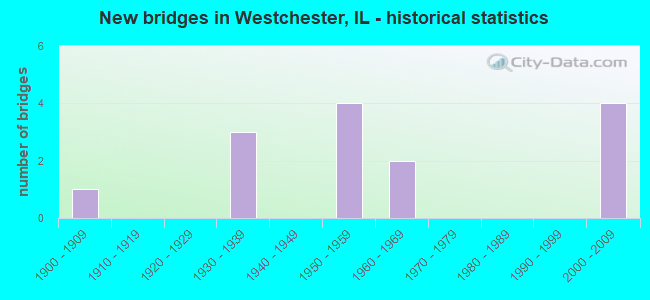
- New bridges - historical statistics
- 11900-1909
- 31930-1939
- 41950-1959
- 21960-1969
- 42000-2009

- Reconstructed bridges - Historical Statistics
- 11980-1989
- 11990-1999
- 12000-2009


- Bridge Condition - Deck
- 25.0%Good
- 50.0%Satisfactory
- 25.0%Serious

- Bridge Condition - Superstructure
- 37.5%Good
- 12.5%Satisfactory
- 25.0%Fair
- 25.0%Serious

- Bridge Condition - Substructure
- 37.5%Good
- 37.5%Satisfactory
- 25.0%Fair

- Bridge Condition - Channel
- 16.7%Very good
- 16.7%Good
- 33.3%Satisfactory
- 16.7%Fair
- 16.7%Poor
Find on map >> Show street view
Structure Number: 160088, Location: 0.5 M E US 45 (Lat: 41.870758, Lng: -87.872908), Route carried "on" structure: Interstate 290, Year Built: 1952, Year Reconstructed: 2000, Status: Open, Structure Length: 3.32m (10.89ft), Average Daily Traffic: 140,700 (year 2021), Truck Traffic: 8%, Average Future Daily Traffic: 201,262 (year 2032), Design Load: HS 20+Mod, Features Intersected: ADDISON CREEK
Minimum Vertical Clearance: 30+ m (98+ ft), Kilometerpoint: 29.032, Lanes on structure: 6, Base Highway Network: Yes, Owner: State Highway Agency, Approaching Roadway Width: 37.9m (124.3ft), Skew: 30 degrees, Material/Design: Concrete continuous, Design/Construction: Slab, Number Of Spans In Main Unit: 3, Length of Maximum Span: 12.6m (41.3ft), Curb-To-Curb Width: 37.9m (124.3ft), Out-to-Out Width: 39.8m (130.6ft)
Condition: Deck: Satisfactory, Superstructure: Fair, Substructure: Good, Channel: Satisfactory, Operating Rating: 56.1 metric tons, Method Used To Determine Operating Rating: Load Factor (LF) rating reported by rating factor (RF) method using MS18 loading, Inventory Rating: 33.7 metric tons, Method Used To Determine Inventory Rating: Load Factor (LF) rating reported by rating factor (RF) method using MS18 loading, Structural Evaluation: Somewhat better than minimum adequacy, Deck Geometry: Superior to present desirable criteria, Waterway Adequacy: Equal to present desirable criteria, Approach Roadway Alignment: Equal to present desirable criteria, Designated Inspection Frequency: Every 24 months, Inspection Date: April 2020, Deck Structure Type: Concrete Cast-file-Place, Wearing Surface/Protective System: Wearing Surface: Other, Deck Protection: Epoxy Coated Reinforcing
Find on map >> Show street view
Structure Number: 160339, Location: 0.1 M S CERMAK RD (Lat: 41.847717, Lng: -87.880722), Route carried "on" structure: US 12, Year Built: 1958, Year Reconstructed: 2003, Status: Open, Structure Length: 4.43m (14.53ft), Average Daily Traffic: 22,800 (year 2021), Truck Traffic: 9%, Average Future Daily Traffic: 21,836 (year 2032), Design Load: HS 20, Features Intersected: SALT CREEK
Minimum Vertical Clearance: 30+ m (98+ ft), Kilometerpoint: 91.811, Lanes on structure: 4, Base Highway Network: Yes, Owner: State Highway Agency, Approaching Roadway Width: 22.3m (73.2ft), Skew: 34 degrees, Material/Design: Steel continuous, Design/Construction: Stringer/Multi-beam, Number Of Spans In Main Unit: 3, Length of Maximum Span: 14.8m (48.6ft), Curb or Sidewalk Widths: Left: 2.7m (8.9ft), Right: 1.2m (3.9ft), Curb-To-Curb Width: 22.3m (73.2ft), Out-to-Out Width: 26.1m (85.6ft)
Condition: Deck: Good, Superstructure: Good, Substructure: Satisfactory, Channel: Good, Operating Rating: 89.1 metric tons, Method Used To Determine Operating Rating: Load Factor (LF) rating reported by rating factor (RF) method using MS18 loading, Inventory Rating: 85.9 metric tons, Method Used To Determine Inventory Rating: Load Factor (LF) rating reported by rating factor (RF) method using MS18 loading, Structural Evaluation: Equal to present minimum criteria, Deck Geometry: Superior to present desirable criteria, Waterway Adequacy: Equal to present desirable criteria, Approach Roadway Alignment: Equal to present desirable criteria, Length Of Structure Improvement: 4.42m (14.50ft), Designated Inspection Frequency: Every 24 months, Inspection Date: September 2020, Bridge Improvement Cost: $959,000, Roadway Improvement Cost: $96,000, Total Project Cost: $1,439,000, Deck Structure Type: Concrete Cast-file-Place, Wearing Surface/Protective System: Deck Protection: Epoxy Coated Reinforcing
Find on map >> Show street view
Structure Number: 160962, Location: 0.8 M E US 45 (Lat: 41.863661, Lng: -87.868003), Route carried "on" structure: Other road , Year Built: 1938, Year Reconstructed: 1991, Status: Open, Structure Length: 24.84m (81.50ft), Average Daily Traffic: 25,000 (year 2021), Truck Traffic: 4%, Average Future Daily Traffic: 25,647 (year 2032), Features Intersected: RR - IHB & GARDNER, Facility Carried by Structure: ROOSEVELT RD
Minimum Vertical Clearance: 30+ m (98+ ft), Kilometerpoint: 4.329, Lanes on structure: 4, Lanes under structure: 2, Base Highway Network: Yes, Owner: State Highway Agency, Approaching Roadway Width: 17.7m (58.1ft), Material/Design: Steel continuous, Design/Construction: Stringer/Multi-beam, Number Of Spans In Main Unit: 13, Length of Maximum Span: 23.5m (77.1ft), Curb or Sidewalk Widths: Left: 1.5m (4.9ft), Right: 1.5m (4.9ft), Curb-To-Curb Width: 14.6m (47.9ft), Out-to-Out Width: 18.3m (60.0ft)
Condition: Deck: Satisfactory, Superstructure: Fair, Substructure: Satisfactory, Operating Rating: 83.9 metric tons, Method Used To Determine Operating Rating: Load Factor (LF) rating reported by rating factor (RF) method using MS18 loading, Inventory Rating: 50.2 metric tons, Method Used To Determine Inventory Rating: Load Factor (LF) rating reported by rating factor (RF) method using MS18 loading, Structural Evaluation: Somewhat better than minimum adequacy, Deck Geometry: High priority of replacement, Approach Roadway Alignment: Equal to present minimum criteria, Length Of Structure Improvement: 26.09m (85.60ft), Designated Inspection Frequency: Every 24 months, Inspection Date: March 2021, Bridge Improvement Cost: $7,529,000, Roadway Improvement Cost: $753,000, Total Project Cost: $11,294,000, Deck Structure Type: Concrete Cast-file-Place, Wearing Surface/Protective System: Deck Protection: Epoxy Coated Reinforcing
Find on map >> Show street view
Structure Number: 162761, Location: 3.7 M W IL 43 (Lat: 41.870433, Lng: -87.877847), Route carried "on" structure: Other road , Year Built: 2002, Status: Open, Structure Length: 6.92m (22.70ft), Average Daily Traffic: 2,200 (year 2018), Truck Traffic: 3%, Average Future Daily Traffic: 7,725 (year 2032), Design Load: HS 20, Features Intersected: I-290 IKE, Facility Carried by Structure: WESTCHESTER BLVD
Minimum Vertical Clearance: 30+ m (98+ ft), Kilometerpoint: 1.770, Lanes on structure: 2, Lanes under structure: 8, Owner: State Highway Agency, Approaching Roadway Width: 9.2m (30.2ft), Skew: 1 degrees, Material/Design: Steel continuous, Design/Construction: Stringer/Multi-beam, Number Of Spans In Main Unit: 3, Length of Maximum Span: 28.0m (91.9ft), Curb or Sidewalk Widths: Left: 2.1m (6.9ft), Right: 2.1m (6.9ft), Curb-To-Curb Width: 9.2m (30.2ft), Out-to-Out Width: 14.0m (45.9ft)
Condition: Deck: Satisfactory, Superstructure: Good, Substructure: Good, Operating Rating: 89.1 metric tons, Method Used To Determine Operating Rating: Load Factor (LF) rating reported by rating factor (RF) method using MS18 loading, Inventory Rating: 62.9 metric tons, Method Used To Determine Inventory Rating: Load Factor (LF) rating reported by rating factor (RF) method using MS18 loading, Structural Evaluation: Better than present minimum criteria, Deck Geometry: Meets minimum limits, Underclear: High priority of corrective action, Approach Roadway Alignment: Equal to present desirable criteria, Designated Inspection Frequency: Every 24 months, Inspection Date: January 2021, Deck Structure Type: Concrete Cast-file-Place, Wearing Surface/Protective System: Deck Protection: Epoxy Coated Reinforcing
Find on map >> Show street view
Structure Number: 162789, Location: 0.6 M E US 45 (Lat: 41.863558, Lng: -87.871858), Route carried "on" structure: Other road , Year Built: 2003, Status: Open, Structure Length: 1.16m (3.81ft), Average Daily Traffic: 25,000 (year 2021), Truck Traffic: 4%, Average Future Daily Traffic: 25,647 (year 2032), Design Load: HS 20, Features Intersected: ADDISON CREEK, Facility Carried by Structure: ROOSEVELT RD
Minimum Vertical Clearance: 30+ m (98+ ft), Kilometerpoint: 4.007, Lanes on structure: 4, Base Highway Network: Yes, Owner: State Highway Agency, Approaching Roadway Width: 17.1m (56.1ft), Material/Design: Steel, Design/Construction: Stringer/Multi-beam, Number Of Spans In Main Unit: 1, Length of Maximum Span: 11.3m (37.1ft), Curb or Sidewalk Widths: Left: 7.0m (23.0ft), Right: 7.0m (23.0ft), Curb-To-Curb Width: 18.3m (60.0ft), Out-to-Out Width: 32.9m (107.9ft)
Condition: Deck: Good, Superstructure: Good, Substructure: Good, Channel: Very good, Operating Rating: 67.1 metric tons, Method Used To Determine Operating Rating: Load Factor (LF) rating reported by rating factor (RF) method using MS18 loading, Inventory Rating: 40.2 metric tons, Method Used To Determine Inventory Rating: Load Factor (LF) rating reported by rating factor (RF) method using MS18 loading, Structural Evaluation: Better than present minimum criteria, Deck Geometry: Somewhat better than minimum adequacy, Waterway Adequacy: Equal to present desirable criteria, Approach Roadway Alignment: Equal to present desirable criteria, Designated Inspection Frequency: Every 48 months, Inspection Date: June 2019, Deck Structure Type: Concrete Cast-file-Place, Wearing Surface/Protective System: Deck Protection: Epoxy Coated Reinforcing
Find on map >> Show street view
Structure Number: 163106, Location: 0.2 M S ROOSEVELTP20 (Lat: 41.861353, Lng: -87.867647), Route carried "on" structure: Other road , Year Built: 1957, Status: Open, Structure Length: 6.89m (22.60ft), Average Daily Traffic: 2,750 (year 2018), Truck Traffic: 8%, Average Future Daily Traffic: 2,350 (year 2032), Design Load: HS 20, Features Intersected: ADDISON CR, Facility Carried by Structure: GARDNER RD
Minimum Vertical Clearance: 30+ m (98+ ft), Kilometerpoint: 3.428, Lanes on structure: 2, Owner: City or Municipal Highway Agency, Approaching Roadway Width: 8.5m (27.9ft), Material/Design: Concrete continuous, Design/Construction: Slab, Number Of Spans In Main Unit: 4, Length of Maximum Span: 19.5m (64.0ft), Curb or Sidewalk Widths: Left: 1.6m (5.2ft), Right: 1.5m (4.9ft), Curb-To-Curb Width: 8.5m (27.9ft), Out-to-Out Width: 12.2m (40.0ft)
Condition: Deck: Satisfactory, Superstructure: Satisfactory, Substructure: Satisfactory, Channel: Poor, Operating Rating: 54.4 metric tons, Method Used To Determine Operating Rating: Load Factor (LF) rating reported by rating factor (RF) method using MS18 loading, Inventory Rating: 32.4 metric tons, Method Used To Determine Inventory Rating: Load Factor (LF) rating reported by rating factor (RF) method using MS18 loading, Structural Evaluation: Equal to present minimum criteria, Deck Geometry: Meets minimum limits, Waterway Adequacy: Equal to present minimum criteria, Approach Roadway Alignment: Equal to present desirable criteria, Designated Inspection Frequency: Every 24 months, Inspection Date: Febuary 2021, Deck Structure Type: Concrete Cast-file-Place
Find on map >> Show street view
Structure Number: 163231, Location: 0.5 MI E.OF US 45 (Lat: 41.870475, Lng: -87.872436), Route carried "on" structure: City street , Year Built: 1952, Status: Open, Structure Length: 3.32m (10.89ft), Average Daily Traffic: 500 (year 2018), Truck Traffic: 8%, Average Future Daily Traffic: 215 (year 2032), Design Load: HS 20, Features Intersected: ADDISON CREEK, Facility Carried by Structure: WEDGEWOOD DRIVE
Minimum Vertical Clearance: 30+ m (98+ ft), Kilometerpoint: 0.274, Lanes on structure: 2, Owner: City or Municipal Highway Agency, Approaching Roadway Width: 7.3m (24.0ft), Material/Design: Concrete continuous, Design/Construction: Slab, Number Of Spans In Main Unit: 3, Length of Maximum Span: 12.5m (41.0ft), Curb or Sidewalk Widths: Left: 1.2m (3.9ft), Right: 1.1m (3.6ft), Curb-To-Curb Width: 7.9m (25.9ft), Out-to-Out Width: 10.5m (34.4ft)
Condition: Deck: Serious, Superstructure: Serious, Substructure: Fair, Channel: Fair, Operating Rating: 32.4 metric tons, Method Used To Determine Operating Rating: Field evaluation and documented engineering judgment, Inventory Rating: 19.4 metric tons, Method Used To Determine Inventory Rating: Field evaluation and documented engineering judgment, Structural Evaluation: High priority of corrective action, Deck Geometry: Somewhat better than minimum adequacy, Waterway Adequacy: Better than present minimum criteria, Approach Roadway Alignment: Equal to present desirable criteria, Designated Inspection Frequency: Every 24 months, Inspection Date: Febuary 2021, Deck Structure Type: Concrete Cast-file-Place, Wearing Surface/Protective System: Wearing Surface: Bituminous
Find on map >> Show street view
Structure Number: 168165, Location: 0.5 MI E OF US 45 (Lat: 41.867217, Lng: -87.871383), Route carried "on" structure: City street , Year Built: 1930, Status: Open, Structure Length: 1.22m (4.00ft), Average Daily Traffic: 475 (year 2018), Truck Traffic: 14%, Average Future Daily Traffic: 215 (year 2032), Features Intersected: ADDISON CR, Facility Carried by Structure: GLADSTONE ST
Minimum Vertical Clearance: 30+ m (98+ ft), Kilometerpoint: 0.467, Lanes on structure: 2, Owner: City or Municipal Highway Agency, Approaching Roadway Width: 7.9m (25.9ft), Material/Design: Concrete, Design/Construction: Tee Beam, Number Of Spans In Main Unit: 1, Length of Maximum Span: 11.6m (38.1ft), Curb or Sidewalk Widths: Left: 2.0m (6.6ft), Right: 2.0m (6.6ft), Curb-To-Curb Width: 9.1m (29.9ft), Out-to-Out Width: 13.4m (44.0ft)
Condition: Deck: Serious, Superstructure: Serious, Substructure: Fair, Channel: Satisfactory, Operating Rating: 35.6 metric tons, Method Used To Determine Operating Rating: Load Factor (LF) rating reported by rating factor (RF) method using MS18 loading, Inventory Rating: 21.4 metric tons, Method Used To Determine Inventory Rating: Load Factor (LF) rating reported by rating factor (RF) method using MS18 loading, Structural Evaluation: High priority of corrective action, Deck Geometry: Equal to present minimum criteria, Waterway Adequacy: Equal to present minimum criteria, Approach Roadway Alignment: Equal to present desirable criteria, Designated Inspection Frequency: Every 24 months, Inspection Date: Febuary 2021, Deck Structure Type: Concrete Cast-file-Place, Wearing Surface/Protective System: Wearing Surface: Bituminous
Find on map >> Show street view
Structure Number: 160631, Location: 0.8 M E US 45 (Lat: 41.850203, Lng: -87.867122), Route carried "under" structure: City street , Year Built: 1961, Structure Length: 0. m, Average Daily Traffic: 1,750 (year 2018), Truck Traffic: 8%, Features Intersected: RR - IHB & GARDNER, Facility Carried by Structure: CERMAK RD (22ND ST
Minimum Vertical Clearance: 4.88m (16.01ft), Kilometerpoint: 0.660, Lanes on structure: 4, Lanes under structure: 2, Material/Design: Steel continuous, Design/Construction: Stringer/Multi-beam, Length of Maximum Span: 27.5m (90.2ft)
Find on map >> Show street view
Structure Number: 160962, Location: 0.8 M E US 45 (Lat: 41.860328, Lng: -87.867600), Route carried "under" structure: Other road , Year Built: 1938, Structure Length: 0. m, Average Daily Traffic: 2,750 (year 2018), Truck Traffic: 8%, Features Intersected: RR - IHB & GARDNER, Facility Carried by Structure: ROOSEVELT RD
Minimum Vertical Clearance: 4.11m (13.48ft), Kilometerpoint: 3.315, Lanes on structure: 4, Lanes under structure: 2, Material/Design: Steel continuous, Design/Construction: Stringer/Multi-beam, Length of Maximum Span: 23.5m (77.1ft)
Find on map >> Show street view
Structure Number: 162019, Location: 0.4 M E US 45 P20 (Lat: 41.863433, Lng: -87.876053), Route carried "under" structure: Other road , Year Built: 1967, Structure Length: 0. m, Average Daily Traffic: 25,000 (year 2021), Truck Traffic: 4%, Features Intersected: ROOSEVELT RD, Facility Carried by Structure: CC RR
Minimum Vertical Clearance: 4.60m (15.09ft), Kilometerpoint: 3.653, Lanes under structure: 4, Material/Design: Steel, Design/Construction: Girder and Floorbeam System, Length of Maximum Span: 43.9m (144.0ft)
Find on map >> Show street view
Structure Number: 162761, Location: 3.7 M W IL 43 (Lat: 41.870272, Lng: -87.877539), Route carried "under" structure: Other road , Year Built: 2002, Structure Length: 0. m, Average Daily Traffic: 27,000 (year 2021), Truck Traffic: 15%, Features Intersected: I-290 IKE, Facility Carried by Structure: WESTCHESTER BLVD
Minimum Vertical Clearance: 4.42m (14.50ft), Kilometerpoint: 2.253, Lanes on structure: 2, Lanes under structure: 2, Material/Design: Steel continuous, Design/Construction: Stringer/Multi-beam, Length of Maximum Span: 28.0m (91.9ft)
Find on map >> Show street view
Structure Number: 162761, Location: 3.7 M W IL 43 (Lat: 41.870433, Lng: -87.877847), Route carried "under" structure: Interstate 290, Year Built: 2002, Structure Length: 0. m, Average Daily Traffic: 131,300 (year 2021), Truck Traffic: 6%, Features Intersected: I-290 IKE, Facility Carried by Structure: WESTCHESTER BLVD
Minimum Vertical Clearance: 5.31m (17.42ft), Kilometerpoint: 28.613, Lanes on structure: 2, Lanes under structure: 6, Material/Design: Steel continuous, Design/Construction: Stringer/Multi-beam, Length of Maximum Span: 28.0m (91.9ft)
Find on map >> Show street view
Structure Number: 163105, Location: 0.15 S ROOSEVELT P2 (Lat: 41.859867, Lng: -87.867581), Route carried "under" structure: Other road , Year Built: 1900, Structure Length: 0. m, Average Daily Traffic: 2,750 (year 2018), Truck Traffic: 8%, Features Intersected: GARDNER RD, Facility Carried by Structure: CC RR
Minimum Vertical Clearance: 5.21m (17.09ft), Kilometerpoint: 3.267, Lanes under structure: 2, Material/Design: Steel, Design/Construction: Girder and Floorbeam System, Length of Maximum Span: 18.0m (59.1ft)