Bridge Statistics for Westlake, Ohio (OH)
Condition, Traffic, Stress, Structural Evaluation, Project Costs
- National Bridge Inventory (NBI) Statistics
- 27Number of bridges
- 236ft / 72.2mTotal length
- $2,460,000Total costs
- 942,805Total average daily traffic
- 42,939Total average daily truck traffic
- National Bridge Inventory (NBI) Registered Bridges for Westlake
- No street view available for this location
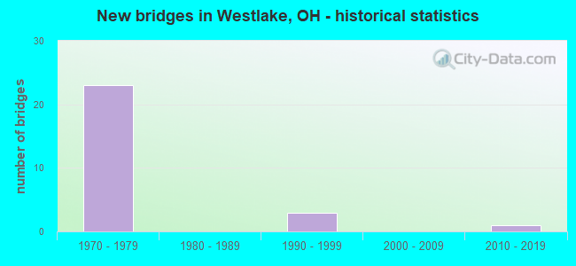
- New bridges - historical statistics
- 231970-1979
- 31990-1999
- 12010-2019

- Reconstructed bridges - Historical Statistics
- 11980-1989
- 61990-1999
- 22000-2009


- Bridge Condition - Deck
- 7.1%Excellent
- 14.3%Very good
- 57.1%Good
- 7.1%Satisfactory
- 14.3%Fair

- Bridge Condition - Superstructure
- 7.1%Excellent
- 21.4%Very good
- 50.0%Good
- 14.3%Satisfactory
- 7.1%Fair

- Bridge Condition - Substructure
- 21.4%Very good
- 50.0%Good
- 28.6%Satisfactory

- Bridge Condition - Channel
- 11.1%Very good
- 33.3%Good
- 33.3%Satisfactory
- 22.2%Fair

- Bridge Condition - Culverts
- 25.0%Good
- 50.0%Satisfactory
- 25.0%Fair
Find on map >> Show street view
Structure Number: 1807633, Location: 0.82 MI E. OF JCT. SR252 (Lat: 41.472900, Lng: -81.900039), Route carried "on" structure: Interstate 90, Year Built: 1975, Status: Open, Structure Length: 0.69m (2.26ft), Average Daily Traffic: 70,688 (year 2015), Truck Traffic: 5%, Average Future Daily Traffic: 98,115 (year 2035), Design Load: HS 20+Mod, Features Intersected: Wolf Creek
Minimum Vertical Clearance: 30+ m (98+ ft), Kilometerpoint: 5.874, Lanes on structure: 6, Base Highway Network: Yes, Owner: State Highway Agency, Approaching Roadway Width: 37.8m (124.0ft), Material/Design: Concrete, Design/Construction: Slab, Number Of Spans In Main Unit: 1, Length of Maximum Span: 6.1m (20.0ft), Curb-To-Curb Width: 110.9m (363.8ft), Out-to-Out Width: 110.9m (363.8ft)
Condition: Deck: Fair, Superstructure: Fair, Substructure: Good, Channel: Satisfactory, Operating Rating: 42.1 metric tons, Method Used To Determine Operating Rating: Load Factor (LF) rating reported by rating factor (RF) method using MS18 loading, Inventory Rating: 32.4 metric tons, Method Used To Determine Inventory Rating: Load Factor (LF) rating reported by rating factor (RF) method using MS18 loading, Structural Evaluation: Somewhat better than minimum adequacy, Deck Geometry: Superior to present desirable criteria, Waterway Adequacy: Equal to present desirable criteria, Approach Roadway Alignment: Equal to present desirable criteria, Designated Inspection Frequency: Every 12 months, Inspection Date: October 2021, Deck Structure Type: Concrete Cast-file-Place, Wearing Surface/Protective System: Wearing Surface: Bituminous, Membrane: Built-up
Find on map >> Show street view
Structure Number: 1807641, Location: 1.37 MI. W. OF JCT. 254 (Lat: 41.475450, Lng: -81.882531), Route carried "on" structure: County highway 52, Year Built: 1977, Year Reconstructed: 1994, Status: Open, Structure Length: 8.14m (26.71ft), Average Daily Traffic: 14,196 (year 2015), Truck Traffic: 4%, Average Future Daily Traffic: 19,704 (year 2035), Design Load: HS 20+Mod, Features Intersected: IR-90 (CLAGUE)
Minimum Vertical Clearance: 30+ m (98+ ft), Kilometerpoint: 6.510, Lanes on structure: 4, Lanes under structure: 7, Owner: State Highway Agency, Approaching Roadway Width: 19.2m (63.0ft), Material/Design: Steel continuous, Design/Construction: Stringer/Multi-beam, Number Of Spans In Main Unit: 4, Length of Maximum Span: 25.3m (83.0ft), Curb or Sidewalk Widths: Left: 1.5m (4.9ft), Right: 1.5m (4.9ft), Curb-To-Curb Width: 15.9m (52.2ft), Out-to-Out Width: 19.5m (64.0ft)
Condition: Deck: Good, Superstructure: Good, Substructure: Satisfactory, Operating Rating: 42.1 metric tons, Method Used To Determine Operating Rating: Load Factor (LF) rating reported by rating factor (RF) method using MS18 loading, Inventory Rating: 32.4 metric tons, Method Used To Determine Inventory Rating: Load Factor (LF) rating reported by rating factor (RF) method using MS18 loading, Structural Evaluation: Equal to present minimum criteria, Deck Geometry: Meets minimum limits, Underclear: Meets minimum limits, Approach Roadway Alignment: Equal to present desirable criteria, Designated Inspection Frequency: Every 12 months, Inspection Date: July 2021, Deck Structure Type: Concrete Cast-file-Place, Wearing Surface/Protective System: Wearing Surface: Integral Concrete
Find on map >> Show street view
Structure Number: 1807676, Location: .5 MI W.COLUMBIA RD INTER (Lat: 41.471011, Lng: -81.911519), Route carried "on" structure: County highway C0084, Year Built: 1977, Year Reconstructed: 2002, Status: Open, Structure Length: 7.56m (24.80ft), Average Daily Traffic: 4,309 (year 2015), Truck Traffic: 5%, Average Future Daily Traffic: 5,981 (year 2035), Design Load: H 20, Features Intersected: IR-90 (CANTERBURY), Facility Carried by Structure: CR 84 CANTERBURY R
Minimum Vertical Clearance: 30+ m (98+ ft), Kilometerpoint: 0.032, Lanes on structure: 2, Lanes under structure: 4, Owner: State Highway Agency, Approaching Roadway Width: 8.5m (27.9ft), Skew: 1 degrees, Material/Design: Steel continuous, Design/Construction: Stringer/Multi-beam, Number Of Spans In Main Unit: 4, Length of Maximum Span: 20.7m (67.9ft), Curb or Sidewalk Widths: Left: 1.2m (3.9ft), Right: 1.2m (3.9ft), Curb-To-Curb Width: 8.5m (27.9ft), Out-to-Out Width: 11.6m (38.1ft)
Condition: Deck: Good, Superstructure: Satisfactory, Substructure: Satisfactory, Operating Rating: 42.1 metric tons, Method Used To Determine Operating Rating: Load Factor (LF) rating reported by rating factor (RF) method using MS18 loading, Inventory Rating: 32.4 metric tons, Method Used To Determine Inventory Rating: Load Factor (LF) rating reported by rating factor (RF) method using MS18 loading, Structural Evaluation: Equal to present minimum criteria, Deck Geometry: Meets minimum limits, Underclear: High priority of corrective action, Approach Roadway Alignment: Equal to present desirable criteria, Length Of Structure Improvement: 7.62m (25.00ft), Designated Inspection Frequency: Every 12 months, Inspection Date: August 2021, Roadway Improvement Cost: $56,000, Total Project Cost: $560,000, Deck Structure Type: Concrete Cast-file-Place, Wearing Surface/Protective System: Wearing Surface: Monolithic Concrete, Membrane: Built-up
Find on map >> Show street view
Structure Number: 1807692, Location: .5 MI. W. BASSET RD INTER (Lat: 41.468769, Lng: -81.960431), Route carried "on" structure: Interstate 90, Year Built: 1971, Year Reconstructed: 2002, Status: Open, Structure Length: 4.79m (15.72ft), Average Daily Traffic: 37,655 (year 2015), Truck Traffic: 5%, Average Future Daily Traffic: 52,265 (year 2035), Design Load: HS 20+Mod, Features Intersected: CR 60 (BRADLEY RD)
Minimum Vertical Clearance: 30+ m (98+ ft), Kilometerpoint: 0.724, Lanes on structure: 3, Lanes under structure: 2, Base Highway Network: Yes, Owner: State Highway Agency, Approaching Roadway Width: 19.1m (62.7ft), Material/Design: Steel continuous, Design/Construction: Stringer/Multi-beam, Number Of Spans In Main Unit: 3, Length of Maximum Span: 19.4m (63.6ft), Curb-To-Curb Width: 19.1m (62.7ft), Out-to-Out Width: 20.0m (65.6ft)
Condition: Deck: Good, Superstructure: Good, Substructure: Good, Operating Rating: 42.1 metric tons, Method Used To Determine Operating Rating: Allowable Stress (AS) rating reported by rating factor (RF) method using MS18 loading, Inventory Rating: 32.4 metric tons, Method Used To Determine Inventory Rating: Allowable Stress (AS) rating reported by rating factor (RF) method using MS18 loading, Structural Evaluation: Better than present minimum criteria, Deck Geometry: Superior to present desirable criteria, Underclear: Meets minimum limits, Approach Roadway Alignment: Equal to present desirable criteria, Designated Inspection Frequency: Every 24 months, Inspection Date: March 2021, Deck Structure Type: Concrete Cast-file-Place, Wearing Surface/Protective System: Wearing Surface: Monolithic Concrete
Find on map >> Show street view
Structure Number: 1807706, Location: .5 MI W. BASSET RD INTER (Lat: 41.468531, Lng: -81.960469), Route carried "on" structure: Interstate 90, Year Built: 1971, Year Reconstructed: 2002, Status: Open, Structure Length: 4.79m (15.72ft), Average Daily Traffic: 37,655 (year 2015), Truck Traffic: 5%, Average Future Daily Traffic: 52,265 (year 2035), Design Load: HS 20+Mod, Features Intersected: CR 60 (BRADLEY RD)
Minimum Vertical Clearance: 30+ m (98+ ft), Kilometerpoint: 0.724, Lanes on structure: 3, Lanes under structure: 2, Base Highway Network: Yes, Owner: State Highway Agency, Approaching Roadway Width: 19.1m (62.7ft), Material/Design: Steel continuous, Design/Construction: Stringer/Multi-beam, Number Of Spans In Main Unit: 3, Length of Maximum Span: 19.4m (63.6ft), Curb-To-Curb Width: 19.1m (62.7ft), Out-to-Out Width: 20.0m (65.6ft)
Condition: Deck: Good, Superstructure: Good, Substructure: Good, Operating Rating: 42.1 metric tons, Method Used To Determine Operating Rating: Allowable Stress (AS) rating reported by rating factor (RF) method using MS18 loading, Inventory Rating: 32.4 metric tons, Method Used To Determine Inventory Rating: Allowable Stress (AS) rating reported by rating factor (RF) method using MS18 loading, Structural Evaluation: Better than present minimum criteria, Deck Geometry: Superior to present desirable criteria, Underclear: Meets minimum limits, Approach Roadway Alignment: Equal to present desirable criteria, Designated Inspection Frequency: Every 24 months, Inspection Date: March 2021, Deck Structure Type: Concrete Cast-file-Place, Wearing Surface/Protective System: Wearing Surface: Monolithic Concrete
Find on map >> Show street view
Structure Number: 1807722, Location: .3 MI. N. OF JCT. SR 254 (Lat: 41.467800, Lng: -81.950981), Route carried "on" structure: County highway C0118, Year Built: 1972, Year Reconstructed: 2000, Status: Open, Structure Length: 9.02m (29.59ft), Average Daily Traffic: 9,242 (year 2015), Truck Traffic: 7%, Average Future Daily Traffic: 12,828 (year 2035), Design Load: H 20, Features Intersected: IR 90, Facility Carried by Structure: CR-118 CROCKER RD
Minimum Vertical Clearance: 30+ m (98+ ft), Kilometerpoint: 0.459, Lanes on structure: 2, Lanes under structure: 5, Base Highway Network: Yes, Owner: State Highway Agency, Approaching Roadway Width: 18.3m (60.0ft), Material/Design: Steel continuous, Design/Construction: Stringer/Multi-beam, Number Of Spans In Main Unit: 4, Length of Maximum Span: 25.0m (82.0ft), Curb or Sidewalk Widths: Left: 1.2m (3.9ft), Right: 1.2m (3.9ft), Curb-To-Curb Width: 15.9m (52.2ft), Out-to-Out Width: 19.1m (62.7ft)
Condition: Deck: Good, Superstructure: Good, Substructure: Good, Operating Rating: 48.6 metric tons, Method Used To Determine Operating Rating: Load and Resistance Factor Rating (LRFR) rating reported by rating factor(RF) method using HL-93 loadings, Inventory Rating: 38.9 metric tons, Method Used To Determine Inventory Rating: Load and Resistance Factor Rating (LRFR) rating reported by rating factor(RF) method using HL-93 loadings, Structural Evaluation: Better than present minimum criteria, Deck Geometry: Superior to present desirable criteria, Underclear: Meets minimum limits, Approach Roadway Alignment: Equal to present desirable criteria, Length Of Structure Improvement: 9.02m (29.59ft), Designated Inspection Frequency: Every 24 months, Inspection Date: August 2021, Roadway Improvement Cost: $130,000, Total Project Cost: $1,300,000, Deck Structure Type: Concrete Cast-file-Place, Wearing Surface/Protective System: Wearing Surface: Monolithic Concrete
Find on map >> Show street view
Structure Number: 1807978, Location: 1.06 MI E.BASSET RD INTER (Lat: 41.466681, Lng: -81.930581), Route carried "on" structure: County highway 162, Year Built: 1972, Year Reconstructed: 2002, Status: Open, Structure Length: 8.14m (26.71ft), Average Daily Traffic: 1,949 (year 2015), Truck Traffic: 5%, Average Future Daily Traffic: 2,705 (year 2035), Design Load: HS 20+Mod, Features Intersected: IR-90 (CAHOON)
Minimum Vertical Clearance: 30+ m (98+ ft), Kilometerpoint: 0.080, Lanes on structure: 2, Lanes under structure: 4, Owner: State Highway Agency, Approaching Roadway Width: 12.2m (40.0ft), Material/Design: Steel continuous, Design/Construction: Stringer/Multi-beam, Number Of Spans In Main Unit: 4, Length of Maximum Span: 23.5m (77.1ft), Curb or Sidewalk Widths: Left: 1.2m (3.9ft), Right: 1.2m (3.9ft), Curb-To-Curb Width: 8.5m (27.9ft), Out-to-Out Width: 11.6m (38.1ft)
Condition: Deck: Good, Superstructure: Good, Substructure: Satisfactory, Operating Rating: 42.1 metric tons, Method Used To Determine Operating Rating: Load Factor (LF) rating reported by rating factor (RF) method using MS18 loading, Inventory Rating: 32.4 metric tons, Method Used To Determine Inventory Rating: Load Factor (LF) rating reported by rating factor (RF) method using MS18 loading, Structural Evaluation: Equal to present minimum criteria, Deck Geometry: Somewhat better than minimum adequacy, Underclear: Somewhat better than minimum adequacy, Approach Roadway Alignment: Equal to present desirable criteria, Length Of Structure Improvement: 8.23m (27.00ft), Designated Inspection Frequency: Every 24 months, Inspection Date: November 2021, Roadway Improvement Cost: $60,000, Total Project Cost: $600,000, Deck Structure Type: Concrete Cast-file-Place, Wearing Surface/Protective System: Wearing Surface: Monolithic Concrete
Find on map >> Show street view
Structure Number: 1808001, Location: .04 MI W. CLAGUE RD INTER (Lat: 41.475839, Lng: -81.881731), Route carried "on" structure: Interstate 90, Year Built: 1973, Status: Open, Structure Length: 0.91m (2.99ft), Average Daily Traffic: 100,109 (year 2015), Truck Traffic: 5%, Average Future Daily Traffic: 138,951 (year 2035), Design Load: HS 20+Mod, Features Intersected: SPERRY CREEK
Minimum Vertical Clearance: 30+ m (98+ ft), Kilometerpoint: 7.435, Lanes on structure: 7, Base Highway Network: Yes, Owner: State Highway Agency, Approaching Roadway Width: 34.4m (112.9ft), Skew: 30 degrees, Material/Design: Concrete, Design/Construction: Culvert, Number Of Spans In Main Unit: 3, Length of Maximum Span: 2.4m (7.9ft)
Condition: Channel: Good, Culverts: Fair, Operating Rating: 42.1 metric tons, Method Used To Determine Operating Rating: Load Factor (LF) rating reported by rating factor (RF) method using MS18 loading, Inventory Rating: 32.4 metric tons, Method Used To Determine Inventory Rating: Load Factor (LF) rating reported by rating factor (RF) method using MS18 loading, Structural Evaluation: Somewhat better than minimum adequacy, Waterway Adequacy: Better than present minimum criteria, Approach Roadway Alignment: Equal to present desirable criteria, Designated Inspection Frequency: Every 12 months, Inspection Date: October 2021
Find on map >> Show street view
Structure Number: 1808087, Location: 2.98 MI E.BASSET RD INTER (Lat: 41.468689, Lng: -81.921461), Route carried "on" structure: Interstate 90, Year Built: 1971, Year Reconstructed: 2002, Status: Open, Structure Length: 4.97m (16.31ft), Average Daily Traffic: 42,874 (year 2015), Truck Traffic: 5%, Average Future Daily Traffic: 59,509 (year 2035), Design Load: HS 20+Mod, Features Intersected: CR-58 (DOVER CENTER RD)
Minimum Vertical Clearance: 30+ m (98+ ft), Kilometerpoint: 4.007, Lanes on structure: 3, Lanes under structure: 2, Base Highway Network: Yes, Owner: State Highway Agency, Approaching Roadway Width: 12.5m (41.0ft), Skew: 1 degrees, Material/Design: Steel continuous, Design/Construction: Stringer/Multi-beam, Number Of Spans In Main Unit: 3, Length of Maximum Span: 20.1m (65.9ft), Curb-To-Curb Width: 17.6m (57.7ft), Out-to-Out Width: 18.5m (60.7ft)
Condition: Deck: Good, Superstructure: Very good, Substructure: Very good, Operating Rating: 42.1 metric tons, Method Used To Determine Operating Rating: Allowable Stress (AS) rating reported by rating factor (RF) method using MS18 loading, Inventory Rating: 32.4 metric tons, Method Used To Determine Inventory Rating: Allowable Stress (AS) rating reported by rating factor (RF) method using MS18 loading, Structural Evaluation: Equal to present desirable criteria, Deck Geometry: Better than present minimum criteria, Underclear: Superior to present desirable criteria, Approach Roadway Alignment: Equal to present desirable criteria, Designated Inspection Frequency: Every 24 months, Inspection Date: March 2021, Deck Structure Type: Concrete Cast-file-Place, Wearing Surface/Protective System: Wearing Surface: Monolithic Concrete
Find on map >> Show street view
Structure Number: 1808095, Location: 2.98 MI E.BASSET RD INTER (Lat: 41.468550, Lng: -81.921439), Route carried "on" structure: Interstate 90, Year Built: 1971, Year Reconstructed: 2002, Status: Open, Structure Length: 4.97m (16.31ft), Average Daily Traffic: 42,874 (year 2015), Truck Traffic: 5%, Average Future Daily Traffic: 59,509 (year 2035), Design Load: HS 20+Mod, Features Intersected: CR-58 (DOVER CENTER RD)
Minimum Vertical Clearance: 30+ m (98+ ft), Kilometerpoint: 4.007, Lanes on structure: 3, Lanes under structure: 2, Base Highway Network: Yes, Owner: State Highway Agency, Approaching Roadway Width: 12.5m (41.0ft), Skew: 1 degrees, Material/Design: Steel continuous, Design/Construction: Stringer/Multi-beam, Number Of Spans In Main Unit: 3, Length of Maximum Span: 20.1m (65.9ft), Curb-To-Curb Width: 17.6m (57.7ft), Out-to-Out Width: 18.5m (60.7ft)
Condition: Deck: Good, Superstructure: Very good, Substructure: Very good, Operating Rating: 42.1 metric tons, Method Used To Determine Operating Rating: Allowable Stress (AS) rating reported by rating factor (RF) method using MS18 loading, Inventory Rating: 32.4 metric tons, Method Used To Determine Inventory Rating: Allowable Stress (AS) rating reported by rating factor (RF) method using MS18 loading, Structural Evaluation: Equal to present desirable criteria, Deck Geometry: Better than present minimum criteria, Underclear: Better than present minimum criteria, Approach Roadway Alignment: Equal to present desirable criteria, Designated Inspection Frequency: Every 24 months, Inspection Date: March 2021, Deck Structure Type: Concrete Cast-file-Place, Wearing Surface/Protective System: Wearing Surface: Monolithic Concrete
Find on map >> Show street view
Structure Number: 1810421, Location: I-90 SR252 JCT (Lat: 41.472539, Lng: -81.901561), Route carried "on" structure: State highway 252, Year Built: 1977, Status: Open, Structure Length: 8.38m (27.49ft), Average Daily Traffic: 21,776 (year 2015), Truck Traffic: 7%, Average Future Daily Traffic: 30,225 (year 2035), Design Load: H 20, Features Intersected: I-90 (CUY-90-0356)
Minimum Vertical Clearance: 30+ m (98+ ft), Kilometerpoint: 14.146, Lanes on structure: 4, Lanes under structure: 4, Base Highway Network: Yes, Owner: State Highway Agency, Approaching Roadway Width: 21.0m (68.9ft), Skew: 11 degrees, Material/Design: Steel continuous, Design/Construction: Stringer/Multi-beam, Number Of Spans In Main Unit: 4, Length of Maximum Span: 20.7m (67.9ft), Curb or Sidewalk Widths: Left: 1.8m (5.9ft), Right: 1.8m (5.9ft), Curb-To-Curb Width: 19.8m (65.0ft), Out-to-Out Width: 24.1m (79.1ft)
Condition: Deck: Fair, Superstructure: Good, Substructure: Good, Operating Rating: 42.1 metric tons, Method Used To Determine Operating Rating: Allowable Stress (AS) rating reported by rating factor (RF) method using MS18 loading, Inventory Rating: 32.4 metric tons, Method Used To Determine Inventory Rating: Allowable Stress (AS) rating reported by rating factor (RF) method using MS18 loading, Structural Evaluation: Better than present minimum criteria, Deck Geometry: Better than present minimum criteria, Underclear: Meets minimum limits, Approach Roadway Alignment: Equal to present desirable criteria, Designated Inspection Frequency: Every 12 months, Inspection Date: December 2021, Deck Structure Type: Concrete Cast-file-Place, Wearing Surface/Protective System: Wearing Surface: Low Slump Concrete, Membrane: Built-up, Deck Protection: Cathodic Protection
Find on map >> Show street view
Structure Number: 1810499, Location: .86 MI E SR252 (Lat: 41.471469, Lng: -81.885619), Route carried "on" structure: State highway 254, Year Built: 1978, Year Reconstructed: 2013, Status: Open, Structure Length: 1.34m (4.40ft), Average Daily Traffic: 13,057 (year 2015), Truck Traffic: 7%, Average Future Daily Traffic: 18,123 (year 2035), Design Load: HS 20+Mod, Features Intersected: SPERRY CRK .86 MI. E 252
Minimum Vertical Clearance: 30+ m (98+ ft), Kilometerpoint: 7.226, Lanes on structure: 3, Owner: State Highway Agency, Approaching Roadway Width: 11.3m (37.1ft), Skew: 3 degrees, Material/Design: Prestressed concrete, Design/Construction: Box Beam or Girders - Multiple, Number Of Spans In Main Unit: 1, Length of Maximum Span: 13.4m (44.0ft), Curb or Sidewalk Widths: Left: 1.5m (4.9ft), Right: 1.5m (4.9ft), Curb-To-Curb Width: 10.4m (34.1ft), Out-to-Out Width: 14.0m (45.9ft)
Condition: Deck: Excellent, Superstructure: Excellent, Substructure: Very good, Channel: Good, Operating Rating: 87.5 metric tons, Method Used To Determine Operating Rating: Load and Resistance Factor Rating (LRFR) rating reported by rating factor(RF) method using HL-93 loadings, Inventory Rating: 61.6 metric tons, Method Used To Determine Inventory Rating: Load and Resistance Factor Rating (LRFR) rating reported by rating factor(RF) method using HL-93 loadings, Structural Evaluation: Equal to present desirable criteria, Deck Geometry: High priority of replacement, Waterway Adequacy: Equal to present desirable criteria, Approach Roadway Alignment: Equal to present desirable criteria, Designated Inspection Frequency: Every 24 months, Inspection Date: October 2021, Deck Structure Type: Other, Wearing Surface/Protective System: Wearing Surface: Monolithic Concrete
Find on map >> Show street view
Structure Number: 1830554, Location: 217' E OF BRADLEY RD (Lat: 41.438989, Lng: -81.960131), Route carried "on" structure: County highway 69, Year Built: 1997, Status: Open, Structure Length: 1.32m (4.33ft), Average Daily Traffic: 9,014 (year 2015), Truck Traffic: 5%, Average Future Daily Traffic: 12,511 (year 2035), Design Load: HS 20+Mod, Features Intersected: SCHWARTZ CREEK
Minimum Vertical Clearance: 30+ m (98+ ft), Kilometerpoint: 1.175, Lanes on structure: 2, Owner: County Highway Agency, Approaching Roadway Width: 8.5m (27.9ft), Skew: 6 degrees, Material/Design: Concrete, Design/Construction: Culvert, Number Of Spans In Main Unit: 1, Length of Maximum Span: 12.5m (41.0ft)
Condition: Channel: Fair, Culverts: Good, Operating Rating: 32.4 metric tons, Method Used To Determine Operating Rating: Load Factor (LF) rating reported by rating factor (RF) method using MS18 loading, Inventory Rating: 19.4 metric tons, Method Used To Determine Inventory Rating: Load Factor (LF) rating reported by rating factor (RF) method using MS18 loading, Structural Evaluation: Meets minimum limits, Waterway Adequacy: Superior to present desirable criteria, Approach Roadway Alignment: Equal to present desirable criteria, Designated Inspection Frequency: Every 24 months, Inspection Date: June 2021
Find on map >> Show street view
Structure Number: 1831704, Location: .2 MI N OF DETROIT RD (Lat: 41.473181, Lng: -81.882219), Route carried "on" structure: County highway 52, Year Built: 1975, Status: Open, Structure Length: 0.91m (2.99ft), Average Daily Traffic: 14,196 (year 2015), Truck Traffic: 4%, Average Future Daily Traffic: 19,704 (year 2035), Design Load: HS 20, Features Intersected: SPERRY CREEK
Minimum Vertical Clearance: 30+ m (98+ ft), Kilometerpoint: 6.260, Lanes on structure: 4, Owner: County Highway Agency, Approaching Roadway Width: 15.9m (52.2ft), Material/Design: Concrete, Design/Construction: Culvert, Number Of Spans In Main Unit: 3, Length of Maximum Span: 2.4m (7.9ft)
Condition: Channel: Satisfactory, Culverts: Satisfactory, Operating Rating: 97.2 metric tons, Method Used To Determine Operating Rating: Load Factor (LF) rating reported by rating factor (RF) method using MS18 loading, Inventory Rating: 77.8 metric tons, Method Used To Determine Inventory Rating: Load Factor (LF) rating reported by rating factor (RF) method using MS18 loading, Structural Evaluation: Equal to present minimum criteria, Waterway Adequacy: Equal to present desirable criteria, Approach Roadway Alignment: Superior to present desirable criteria, Designated Inspection Frequency: Every 12 months, Inspection Date: June 2021
Find on map >> Show street view
Structure Number: 1831976, Location: 60 FT SOUTH OF CROCKER RD (Lat: 41.446831, Lng: -81.948539), Route carried "on" structure: County highway 69, Year Built: 1979, Status: Open, Structure Length: 0.76m (2.49ft), Average Daily Traffic: 9,014 (year 2015), Truck Traffic: 5%, Average Future Daily Traffic: 12,511 (year 2035), Design Load: HS 20, Features Intersected: PORTER CREEK
Minimum Vertical Clearance: 30+ m (98+ ft), Kilometerpoint: 2.527, Lanes on structure: 4, Owner: County Highway Agency, Approaching Roadway Width: 12.2m (40.0ft), Skew: 5 degrees, Material/Design: Concrete, Design/Construction: Culvert, Number Of Spans In Main Unit: 1, Length of Maximum Span: 7.1m (23.3ft)
Condition: Channel: Fair, Culverts: Satisfactory, Operating Rating: 58.3 metric tons, Method Used To Determine Operating Rating: Load Factor (LF) rating reported by rating factor (RF) method using MS18 loading, Inventory Rating: 35.0 metric tons, Method Used To Determine Inventory Rating: Load Factor (LF) rating reported by rating factor (RF) method using MS18 loading, Structural Evaluation: Equal to present minimum criteria, Waterway Adequacy: Equal to present desirable criteria, Approach Roadway Alignment: Equal to present desirable criteria, Designated Inspection Frequency: Every 12 months, Inspection Date: June 2021
Find on map >> Show street view
Structure Number: 1832387, Location: 900' S OF HILLIARD RD (Lat: 41.457350, Lng: -81.921900), Route carried "on" structure: County highway 58, Year Built: 1996, Status: Open, Structure Length: 2.23m (7.32ft), Average Daily Traffic: 12,658 (year 2015), Truck Traffic: 2%, Average Future Daily Traffic: 17,569 (year 2035), Design Load: HS 20+Mod, Features Intersected: CAHOON CREEK
Minimum Vertical Clearance: 30+ m (98+ ft), Kilometerpoint: 5.102, Lanes on structure: 2, Owner: County Highway Agency, Approaching Roadway Width: 7.9m (25.9ft), Skew: 5 degrees, Material/Design: Prestressed concrete, Design/Construction: Box Beam or Girders - Multiple, Number Of Spans In Main Unit: 2, Length of Maximum Span: 10.7m (35.1ft), Curb or Sidewalk Widths: Left: 1.8m (5.9ft), Right: 1.8m (5.9ft), Curb-To-Curb Width: 7.9m (25.9ft), Out-to-Out Width: 12.2m (40.0ft)
Condition: Deck: Satisfactory, Superstructure: Satisfactory, Substructure: Satisfactory, Channel: Satisfactory, Operating Rating: 77.8 metric tons, Method Used To Determine Operating Rating: Load Factor (LF) rating reported by rating factor (RF) method using MS18 loading, Inventory Rating: 46.7 metric tons, Method Used To Determine Inventory Rating: Load Factor (LF) rating reported by rating factor (RF) method using MS18 loading, Structural Evaluation: Equal to present minimum criteria, Deck Geometry: High priority of replacement, Waterway Adequacy: Better than present minimum criteria, Approach Roadway Alignment: Equal to present desirable criteria, Designated Inspection Frequency: Every 12 months, Inspection Date: June 2021, Deck Structure Type: Concrete Cast-file-Place, Wearing Surface/Protective System: Wearing Surface: Bituminous, Membrane: Built-up, Deck Protection: Epoxy Coated Reinforcing
Find on map >> Show street view
Structure Number: 1832808, Location: 600 FT.W.OF DOVER CTR RD (Lat: 41.459939, Lng: -81.923700), Route carried "on" structure: County highway 69, Year Built: 1990, Status: Open, Structure Length: 2.61m (8.56ft), Average Daily Traffic: 9,014 (year 2015), Truck Traffic: 5%, Average Future Daily Traffic: 12,511 (year 2035), Design Load: HS 20, Features Intersected: CAHOON CREEK
Minimum Vertical Clearance: 30+ m (98+ ft), Kilometerpoint: 5.166, Lanes on structure: 4, Owner: County Highway Agency, Approaching Roadway Width: 7.9m (25.9ft), Skew: 2 degrees, Material/Design: Steel, Design/Construction: Stringer/Multi-beam, Number Of Spans In Main Unit: 1, Length of Maximum Span: 24.4m (80.1ft), Curb or Sidewalk Widths: Left: 1.8m (5.9ft), Right: 1.8m (5.9ft), Curb-To-Curb Width: 19.8m (65.0ft), Out-to-Out Width: 24.1m (79.1ft)
Condition: Deck: Very good, Superstructure: Good, Substructure: Good, Channel: Very good, Operating Rating: 70.6 metric tons, Method Used To Determine Operating Rating: Load Factor (LF) rating reported by rating factor (RF) method using MS18 loading, Inventory Rating: 42.4 metric tons, Method Used To Determine Inventory Rating: Load Factor (LF) rating reported by rating factor (RF) method using MS18 loading, Structural Evaluation: Better than present minimum criteria, Deck Geometry: Better than present minimum criteria, Waterway Adequacy: Superior to present desirable criteria, Approach Roadway Alignment: Better than present minimum criteria, Designated Inspection Frequency: Every 24 months, Inspection Date: June 2021, Deck Structure Type: Concrete Cast-file-Place, Wearing Surface/Protective System: Wearing Surface: Latex Concrete, Deck Protection: Epoxy Coated Reinforcing
Find on map >> Show street view
Structure Number: 1835041, Location: 1000 FT N OF HILLIARD BD (Lat: 41.465500, Lng: -81.882581), Route carried "on" structure: County highway 52, Year Built: 2010, Status: Open, Structure Length: 0.69m (2.26ft), Average Daily Traffic: 14,196 (year 2015), Truck Traffic: 4%, Average Future Daily Traffic: 19,704 (year 2035), Design Load: HL 93, Features Intersected: SPERRY CREEK
Minimum Vertical Clearance: 30+ m (98+ ft), Kilometerpoint: 5.375, Lanes on structure: 3, Owner: County Highway Agency, Approaching Roadway Width: 11.6m (38.1ft), Skew: 1 degrees, Material/Design: Concrete, Design/Construction: Frame, Number Of Spans In Main Unit: 1, Length of Maximum Span: 6.6m (21.7ft), Curb or Sidewalk Widths: Left: 4.0m (13.1ft), Right: 4.0m (13.1ft), Curb-To-Curb Width: 11.6m (38.1ft), Out-to-Out Width: 22.9m (75.1ft)
Condition: Deck: Very good, Superstructure: Very good, Substructure: Good, Channel: Good, Operating Rating: 47.0 metric tons, Method Used To Determine Operating Rating: Load Factor (LF) rating reported by rating factor (RF) method using MS18 loading, Inventory Rating: 38.9 metric tons, Method Used To Determine Inventory Rating: Load Factor (LF) rating reported by rating factor (RF) method using MS18 loading, Structural Evaluation: Better than present minimum criteria, Deck Geometry: High priority of replacement, Waterway Adequacy: Equal to present desirable criteria, Approach Roadway Alignment: Superior to present desirable criteria, Designated Inspection Frequency: Every 24 months, Inspection Date: June 2021, Deck Structure Type: Concrete Cast-file-Place, Wearing Surface/Protective System: Wearing Surface: Bituminous, Membrane: Preformed Fabric, Deck Protection: Epoxy Coated Reinforcing
Find on map >> Show street view
Structure Number: 1807641, Location: 1.37 MI. W. OF JCT. 254 (Lat: 41.475450, Lng: -81.882531), Route carried "under" structure: Interstate 90, Year Built: 1977, Structure Length: 0. m, Average Daily Traffic: 102,343 (year 2016), Truck Traffic: 4%, Features Intersected: CR-52 (CLAGUE RD), Facility Carried by Structure: CR 52 CLAGUE RD
Minimum Vertical Clearance: 5.65m (18.54ft), Kilometerpoint: 7.363, Lanes on structure: 4, Lanes under structure: 7, Material/Design: Steel continuous, Design/Construction: Stringer/Multi-beam, Length of Maximum Span: 25.3m (83.0ft)
Find on map >> Show street view
Structure Number: 1807676, Location: .5 MI W.COLUMBIA RD INTER (Lat: 41.471011, Lng: -81.911519), Route carried "under" structure: Interstate 90, Year Built: 1977, Structure Length: 0. m, Average Daily Traffic: 87,610 (year 2016), Truck Traffic: 4%, Features Intersected: CR-84 (CANTERBURY RD), Facility Carried by Structure: CR 84 CANTERBURY R
Minimum Vertical Clearance: 4.88m (16.01ft), Kilometerpoint: 4.871, Lanes on structure: 2, Lanes under structure: 4, Material/Design: Steel continuous, Design/Construction: Stringer/Multi-beam, Length of Maximum Span: 20.7m (67.9ft)
Find on map >> Show street view
Structure Number: 1807692, Location: .5 MI. W. BASSET RD INTER (Lat: 41.468769, Lng: -81.960431), Route carried "under" structure: County highway 60, Year Built: 1971, Structure Length: 0. m, Average Daily Traffic: 11,087 (year 2015), Truck Traffic: 5%, Features Intersected: I-90 WB, Facility Carried by Structure: IR 90-WB
Minimum Vertical Clearance: 4.72m (15.49ft), Kilometerpoint: 14.516, Lanes on structure: 3, Lanes under structure: 2, Material/Design: Steel continuous, Design/Construction: Stringer/Multi-beam, Length of Maximum Span: 19.4m (63.6ft)
Find on map >> Show street view
Structure Number: 1807706, Location: .5 MI W. BASSET RD INTER (Lat: 41.468531, Lng: -81.960469), Route carried "under" structure: County highway 60, Year Built: 1971, Structure Length: 0. m, Average Daily Traffic: 11,087 (year 2015), Truck Traffic: 5%, Features Intersected: I-90-EB, Facility Carried by Structure: IR 90-EB
Minimum Vertical Clearance: 4.60m (15.09ft), Kilometerpoint: 14.500, Lanes on structure: 3, Lanes under structure: 2, Material/Design: Steel continuous, Design/Construction: Stringer/Multi-beam, Length of Maximum Span: 19.4m (63.6ft)
Find on map >> Show street view
Structure Number: 1807722, Location: .3 MI. N. OF JCT. SR 254 (Lat: 41.467800, Lng: -81.950981), Route carried "under" structure: Interstate 90, Year Built: 1972, Structure Length: 0. m, Average Daily Traffic: 87,610 (year 2016), Truck Traffic: 4%, Features Intersected: CR-118 (CROCKER RD), Facility Carried by Structure: CR-118 CROCKER RD
Minimum Vertical Clearance: 4.85m (15.91ft), Kilometerpoint: 1.518, Lanes on structure: 2, Lanes under structure: 5, Material/Design: Steel continuous, Design/Construction: Stringer/Multi-beam, Length of Maximum Span: 25.0m (82.0ft)
Find on map >> Show street view
Structure Number: 1807978, Location: 1.06 MI E.BASSET RD INTER (Lat: 41.466681, Lng: -81.930581), Route carried "under" structure: Interstate 90, Year Built: 1972, Structure Length: 0. m, Average Daily Traffic: 87,610 (year 2016), Truck Traffic: 4%, Features Intersected: CR-162 (CAHOON RD), Facility Carried by Structure: CR-162 CAHOON RD
Minimum Vertical Clearance: 4.93m (16.17ft), Kilometerpoint: 3.228, Lanes on structure: 2, Lanes under structure: 4, Material/Design: Steel continuous, Design/Construction: Stringer/Multi-beam, Length of Maximum Span: 23.5m (77.1ft)
Find on map >> Show street view
Structure Number: 1808087, Location: 2.98 MI E.BASSET RD INTER (Lat: 41.468689, Lng: -81.921461), Route carried "under" structure: County highway 58, Year Built: 1971, Structure Length: 0. m, Average Daily Traffic: 10,147 (year 2015), Truck Traffic: 2%, Features Intersected: I-90-WB, Facility Carried by Structure: IR 90 WB
Minimum Vertical Clearance: 5.61m (18.41ft), Kilometerpoint: 14.516, Lanes on structure: 3, Lanes under structure: 2, Material/Design: Steel continuous, Design/Construction: Stringer/Multi-beam, Length of Maximum Span: 20.1m (65.9ft)
Find on map >> Show street view
Structure Number: 1808095, Location: 2.98 MI E.BASSET RD INTER (Lat: 41.468550, Lng: -81.921439), Route carried "under" structure: County highway 58, Year Built: 1971, Structure Length: 0. m, Average Daily Traffic: 10,147 (year 2015), Truck Traffic: 2%, Features Intersected: I-90-EB, Facility Carried by Structure: IR 90 EB
Minimum Vertical Clearance: 5.05m (16.57ft), Kilometerpoint: 14.500, Lanes on structure: 3, Lanes under structure: 2, Material/Design: Steel continuous, Design/Construction: Stringer/Multi-beam, Length of Maximum Span: 20.1m (65.9ft)
Find on map >> Show street view
Structure Number: 1810421, Location: I-90 SR252 JCT (Lat: 41.472539, Lng: -81.901561), Route carried "under" structure: Interstate 90, Year Built: 1977, Structure Length: 0. m, Average Daily Traffic: 70,688 (year 2015), Truck Traffic: 5%, Features Intersected: SR 252 (0879) COLUMBIA R, Facility Carried by Structure: SR 252
Minimum Vertical Clearance: 4.65m (15.26ft), Kilometerpoint: 5.729, Lanes on structure: 4, Lanes under structure: 4, Material/Design: Steel continuous, Design/Construction: Stringer/Multi-beam, Length of Maximum Span: 20.7m (67.9ft)