Bridge Statistics for Westland, Michigan (MI)
Condition, Traffic, Stress, Structural Evaluation, Project Costs
- National Bridge Inventory (NBI) Statistics
- 18Number of bridges
- 223ft / 68.1mTotal length
- $80,000Total costs
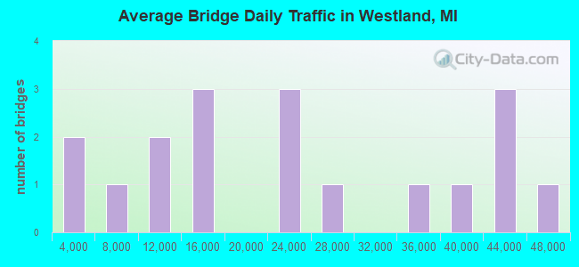
- 409,991Total average daily traffic
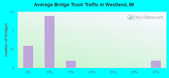
- 21,507Total average daily truck traffic
- National Bridge Inventory (NBI) Registered Bridges for Westland
- No street view available for this location
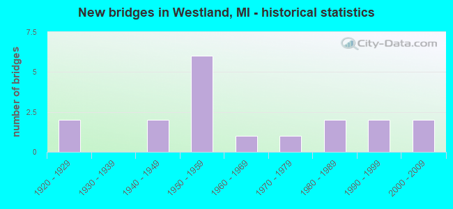
- New bridges - historical statistics
- 21920-1929
- 21940-1949
- 61950-1959
- 11960-1969
- 11970-1979
- 21980-1989
- 21990-1999
- 22000-2009
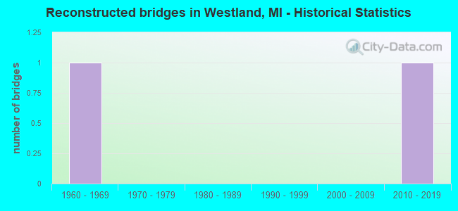
- Reconstructed bridges - Historical Statistics
- 11960-1969
- 01970-1979
- 01980-1989
- 01990-1999
- 02000-2009
- 12010-2019
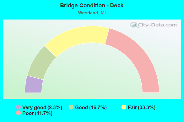
- Bridge Condition - Deck
- 8.3%Very good
- 16.7%Good
- 33.3%Fair
- 41.7%Poor
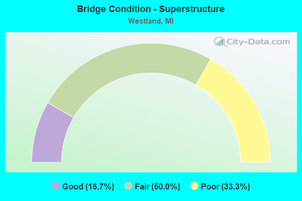
- Bridge Condition - Superstructure
- 16.7%Good
- 50.0%Fair
- 33.3%Poor
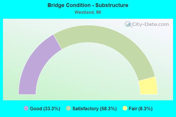
- Bridge Condition - Substructure
- 33.3%Good
- 58.3%Satisfactory
- 8.3%Fair
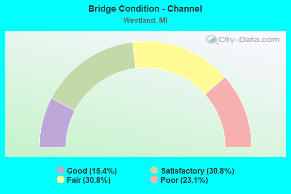
- Bridge Condition - Channel
- 15.4%Good
- 30.8%Satisfactory
- 30.8%Fair
- 23.1%Poor
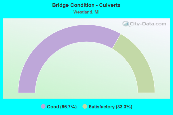
- Bridge Condition - Culverts
- 66.7%Good
- 33.3%Satisfactory
Find on map >> Show street view
Structure Number: 1133, Location: UNION TWP SEC 4 (Lat: 42.065436, Lng: -85.128197), Route carried "on" structure: County highway 1257, Year Built: 1955, Status: Open, Structure Length: 3.35m (10.99ft), Average Daily Traffic: 2,155 (year 2004), Truck Traffic: 4%, Average Future Daily Traffic: 3,202 (year 2024), Design Load: H 20, Features Intersected: COLDWATER RIVER, Facility Carried by Structure: UNION CITY ROAD
Minimum Vertical Clearance: 30.48m (100.00ft), Kilometerpoint: 20.306, Lanes on structure: 2, Owner: County Highway Agency, Approaching Roadway Width: 9.1m (29.9ft), Skew: 1 degrees, Material/Design: Steel continuous, Design/Construction: Stringer/Multi-beam, Number Of Spans In Main Unit: 3, Length of Maximum Span: 12.2m (40.0ft), Curb-To-Curb Width: 7.3m (24.0ft), Out-to-Out Width: 9.1m (29.9ft)
Condition: Deck: Fair, Superstructure: Fair, Substructure: Good, Channel: Fair, Operating Rating: 76.3 metric tons, Method Used To Determine Operating Rating: Load Factor (LF), Inventory Rating: 36.6 metric tons, Method Used To Determine Inventory Rating: Load Factor (LF), Structural Evaluation: Somewhat better than minimum adequacy, Deck Geometry: High priority of replacement, Waterway Adequacy: Equal to present desirable criteria, Approach Roadway Alignment: Equal to present desirable criteria, Length Of Structure Improvement: 3.35m (10.99ft), Designated Inspection Frequency: Every 24 months, Inspection Date: October 2020, Bridge Improvement Cost: $50,000, Total Project Cost: $60,000, Deck Structure Type: Concrete Cast-file-Place, Wearing Surface/Protective System: Wearing Surface: Bituminous
Find on map >> Show street view
Structure Number: 1215, Location: 1.2 MI N OF BRANCH COL (Lat: 42.087636, Lng: -84.997619), Route carried "on" structure: Interstate 69, Year Built: 1968, Status: Open, Structure Length: 3.96m (12.99ft), Average Daily Traffic: 11,162 (year 2007), Truck Traffic: 33%, Average Future Daily Traffic: 11,991 (year 2018), Design Load: HS 20+Mod, Features Intersected: ST JOSEPH RIVER
Minimum Vertical Clearance: 30.48m (100.00ft), Kilometerpoint: 2.205, Lanes on structure: 2, Base Highway Network: Yes (Inventory Route: 129, Subroute: 2), Owner: State Highway Agency, Approaching Roadway Width: 11.6m (38.1ft), Material/Design: Prestressed concrete, Design/Construction: Stringer/Multi-beam, Number Of Spans In Main Unit: 3, Length of Maximum Span: 15.2m (49.9ft), Curb-To-Curb Width: 11.6m (38.1ft), Out-to-Out Width: 12.9m (42.3ft)
Condition: Deck: Fair, Superstructure: Fair, Substructure: Satisfactory, Channel: Fair, Operating Rating: 72.3 metric tons, Method Used To Determine Operating Rating: Load Factor (LF) rating reported by rating factor (RF) method using MS18 loading, Inventory Rating: 43.1 metric tons, Method Used To Determine Inventory Rating: Load Factor (LF) rating reported by rating factor (RF) method using MS18 loading, Structural Evaluation: Somewhat better than minimum adequacy, Deck Geometry: Equal to present minimum criteria, Waterway Adequacy: Equal to present desirable criteria, Approach Roadway Alignment: Equal to present desirable criteria, Designated Inspection Frequency: Every 24 months, Inspection Date: June 2021, Deck Structure Type: Concrete Cast-file-Place, Wearing Surface/Protective System: Wearing Surface: Monolithic Concrete
Find on map >> Show street view
Structure Number: 1133, Location: 4.4 MI W OF GARDEN CITY (Lat: 42.323225, Lng: -83.440075), Route carried "on" structure: State highway 153, Year Built: 1974, Status: Open, Structure Length: 0.70m (2.30ft), Average Daily Traffic: 42,245 (year 2007), Truck Traffic: 6%, Average Future Daily Traffic: 46,239 (year 2018), Features Intersected: WILLOW CREEK
Minimum Vertical Clearance: 30+ m (98+ ft), Kilometerpoint: 8.750, Lanes on structure: 3, Base Highway Network: Yes (Inventory Route: 159, Subroute: 10), Owner: State Highway Agency, Approaching Roadway Width: 10.9m (35.8ft), Material/Design: Concrete, Design/Construction: Culvert, Number Of Spans In Main Unit: 2, Length of Maximum Span: 3.0m (9.8ft), Curb-To-Curb Width: 13.2m (43.3ft), Out-to-Out Width: 190.2m (624.0ft)
Condition: Channel: Good, Culverts: Satisfactory, Operating Rating: 67.6 metric tons, Method Used To Determine Operating Rating: Field evaluation and documented engineering judgment, Inventory Rating: 40.5 metric tons, Method Used To Determine Inventory Rating: Field evaluation and documented engineering judgment, Structural Evaluation: Equal to present minimum criteria, Deck Geometry: Somewhat better than minimum adequacy, Waterway Adequacy: Equal to present minimum criteria, Approach Roadway Alignment: Equal to present minimum criteria, Length Of Structure Improvement: 0.55m (1.80ft), Designated Inspection Frequency: Every 24 months, Inspection Date: June 2021, Bridge Improvement Cost: $17,000, Roadway Improvement Cost: $2,000, Total Project Cost: $20,000 ( Estimate for 2050), Wearing Surface/Protective System: Wearing Surface: Bituminous
Find on map >> Show street view
Structure Number: 11332, Location: 1M E OF I-275 IN WESTLAND (Lat: 42.323547, Lng: -83.424600), Route carried "on" structure: State highway 153, Year Built: 1982, Status: Open, Structure Length: 34.79m (114.14ft), Average Daily Traffic: 46,461 (year 2011), Truck Traffic: 4%, Average Future Daily Traffic: 51,849 (year 2031), Design Load: HS 20, Features Intersected: CSX RR
Minimum Vertical Clearance: 30.48m (100.00ft), Kilometerpoint: 10.025, Lanes on structure: 5, Base Highway Network: Yes (Inventory Route: 159, Subroute: 10), Owner: State Highway Agency, Approaching Roadway Width: 20.7m (67.9ft), Material/Design: Steel continuous, Design/Construction: Stringer/Multi-beam, Number Of Spans In Main Unit: 3, Number Of Approach Spans: 10, Length of Maximum Span: 39.6m (129.9ft), Curb-To-Curb Width: 20.7m (67.9ft), Out-to-Out Width: 21.9m (71.9ft)
Condition: Deck: Good, Superstructure: Good, Substructure: Satisfactory, Operating Rating: 62.5 metric tons, Method Used To Determine Operating Rating: Load Factor (LF) rating reported by rating factor (RF) method using MS18 loading, Inventory Rating: 37.6 metric tons, Method Used To Determine Inventory Rating: Load Factor (LF) rating reported by rating factor (RF) method using MS18 loading, Structural Evaluation: Equal to present minimum criteria, Deck Geometry: Somewhat better than minimum adequacy, Underclear: High priority of corrective action, Approach Roadway Alignment: Equal to present desirable criteria, Designated Inspection Frequency: Every 24 months, Inspection Date: June 2021, Deck Structure Type: Concrete Cast-file-Place, Wearing Surface/Protective System: Wearing Surface: Epoxy Overlay, Deck Protection: Epoxy Coated Reinforcing
Find on map >> Show street view
Structure Number: 12071, Location: WESTLAND W/MERRIMAN (Lat: 42.341083, Lng: -83.351286), Route carried "on" structure: County highway 2057, Year Built: 1948, Status: Posted for load, Structure Length: 2.77m (9.09ft), Average Daily Traffic: 14,193 (year 1996), Average Future Daily Traffic: 15,244 (year 2015), Design Load: HS 20, Features Intersected: MIDDLE ROUGE RIVER, Facility Carried by Structure: E N HINES DRIVE
Minimum Vertical Clearance: 30+ m (98+ ft), Kilometerpoint: 13.664, Lanes on structure: 2, Base Highway Network: Yes (Inventory Route: 168, Subroute: 9), Owner: County Highway Agency, Approaching Roadway Width: 21.3m (69.9ft), Material/Design: Concrete continuous, Design/Construction: Slab, Number Of Spans In Main Unit: 3, Length of Maximum Span: 10.6m (34.8ft), Curb or Sidewalk Widths: Left: 2.4m (7.9ft), Right: 2.4m (7.9ft), Curb-To-Curb Width: 14.6m (47.9ft), Out-to-Out Width: 20.2m (66.3ft)
Condition: Deck: Poor, Superstructure: Poor, Substructure: Satisfactory, Channel: Poor, Operating Rating: 34.0 metric tons, Method Used To Determine Operating Rating: Load Factor (LF) rating reported by rating factor (RF) method using MS18 loading, Inventory Rating: 20.4 metric tons, Method Used To Determine Inventory Rating: Load Factor (LF) rating reported by rating factor (RF) method using MS18 loading, Structural Evaluation: Meets minimum limits, Deck Geometry: Superior to present desirable criteria, Waterway Adequacy: Better than present minimum criteria, Approach Roadway Alignment: Equal to present desirable criteria, Bridge Posting: Required (Relationship of Operating Rating to Maximum Legal Load: 20.0 - 29.9% below), Designated Inspection Frequency: Every 12 months, Inspection Date: June 2021, Deck Structure Type: Concrete Cast-file-Place, Wearing Surface/Protective System: Wearing Surface: Bituminous
Find on map >> Show street view
Structure Number: 12143, Location: WESTLAND S/JOY (Lat: 42.351839, Lng: -83.386075), Route carried "on" structure: County highway 2057, Year Built: 1958, Status: Posted for load, Structure Length: 2.77m (9.09ft), Average Daily Traffic: 40,380 (year 1997), Truck Traffic: 5%, Average Future Daily Traffic: 37,761 (year 2015), Design Load: HS 20, Features Intersected: TONQUISH CREEK, Facility Carried by Structure: WAYNE ROAD
Minimum Vertical Clearance: 30.48m (100.00ft), Kilometerpoint: 18.267, Lanes on structure: 4, Base Highway Network: Yes (Inventory Route: 471, Subroute: 70), Owner: County Highway Agency, Approaching Roadway Width: 18.2m (59.7ft), Skew: 3 degrees, Material/Design: Concrete continuous, Design/Construction: Slab, Number Of Spans In Main Unit: 3, Length of Maximum Span: 10.6m (34.8ft), Curb or Sidewalk Widths: Left: 1.8m (5.9ft), Right: 1.8m (5.9ft), Curb-To-Curb Width: 14.6m (47.9ft), Out-to-Out Width: 18.9m (62.0ft)
Condition: Deck: Poor, Superstructure: Poor, Substructure: Satisfactory, Channel: Satisfactory, Operating Rating: 43.7 metric tons, Method Used To Determine Operating Rating: Load Factor (LF) rating reported by rating factor (RF) method using MS18 loading, Inventory Rating: 26.2 metric tons, Method Used To Determine Inventory Rating: Load Factor (LF) rating reported by rating factor (RF) method using MS18 loading, Structural Evaluation: Meets minimum limits, Deck Geometry: High priority of replacement, Waterway Adequacy: Equal to present desirable criteria, Approach Roadway Alignment: Equal to present desirable criteria, Bridge Posting: Required (Relationship of Operating Rating to Maximum Legal Load: 0.1 - 9.9% below), Designated Inspection Frequency: Every 12 months, Inspection Date: May 2021, Deck Structure Type: Concrete Cast-file-Place, Wearing Surface/Protective System: Wearing Surface: Bituminous
Find on map >> Show street view
Structure Number: 1215, Location: WAYNE/WESTLANDN/MICHIGAN (Lat: 42.288744, Lng: -83.348908), Route carried "on" structure: County highway 2057, Year Built: 1929, Status: Open, Structure Length: 3.20m (10.50ft), Average Daily Traffic: 26,614 (year 1997), Truck Traffic: 3%, Average Future Daily Traffic: 26,000 (year 2015), Design Load: HS 20+Mod, Features Intersected: LOWER ROUGE RIVER, Facility Carried by Structure: MERRIMAN ROAD
Minimum Vertical Clearance: 30.48m (100.00ft), Kilometerpoint: 8.119, Lanes on structure: 4, Base Highway Network: Yes, Owner: County Highway Agency, Approaching Roadway Width: 18.9m (62.0ft), Material/Design: Concrete continuous, Design/Construction: Tee Beam, Number Of Spans In Main Unit: 1, Length of Maximum Span: 16.1m (52.8ft), Curb or Sidewalk Widths: Left: 1.6m (5.2ft), Right: 1.6m (5.2ft), Curb-To-Curb Width: 14.0m (45.9ft), Out-to-Out Width: 18.1m (59.4ft)
Condition: Deck: Poor, Superstructure: Fair, Substructure: Good, Channel: Satisfactory, Operating Rating: 79.1 metric tons, Method Used To Determine Operating Rating: Load and Resistance Factor Rating (LRFR) rating reported by rating factor(RF) method using HL-93 loadings, Inventory Rating: 60.9 metric tons, Method Used To Determine Inventory Rating: Load and Resistance Factor Rating (LRFR) rating reported by rating factor(RF) method using HL-93 loadings, Structural Evaluation: Somewhat better than minimum adequacy, Deck Geometry: High priority of replacement, Waterway Adequacy: Equal to present desirable criteria, Approach Roadway Alignment: Equal to present desirable criteria, Designated Inspection Frequency: Every 12 months, Inspection Date: May 2021, Deck Structure Type: Concrete Cast-file-Place, Wearing Surface/Protective System: Wearing Surface: Integral Concrete, Deck Protection: Epoxy Coated Reinforcing
Find on map >> Show street view
Structure Number: 12151, Location: WESTLAND N/WARREN (Lat: 42.342000, Lng: -83.349308), Route carried "on" structure: County highway 2057, Year Built: 1929, Year Reconstructed: 1969, Status: Open, Structure Length: 2.37m (7.78ft), Average Daily Traffic: 39,205 (year 1996), Truck Traffic: 5%, Average Future Daily Traffic: 37,409 (year 2015), Design Load: HS 20+Mod, Features Intersected: MIDDLE ROUGE RIVER, Facility Carried by Structure: MERRIMAN ROAD
Minimum Vertical Clearance: 30.48m (100.00ft), Kilometerpoint: 14.066, Lanes on structure: 4, Base Highway Network: Yes, Owner: County Highway Agency, Approaching Roadway Width: 14.6m (47.9ft), Material/Design: Concrete, Design/Construction: Tee Beam, Number Of Spans In Main Unit: 2, Length of Maximum Span: 10.9m (35.8ft), Curb or Sidewalk Widths: Left: 1.2m (3.9ft), Right: 1.2m (3.9ft), Curb-To-Curb Width: 14.6m (47.9ft), Out-to-Out Width: 17.8m (58.4ft)
Condition: Deck: Poor, Superstructure: Poor, Substructure: Fair, Channel: Poor, Operating Rating: 95.3 metric tons, Method Used To Determine Operating Rating: Load Factor (LF) rating reported by rating factor (RF) method using MS18 loading, Inventory Rating: 57.0 metric tons, Method Used To Determine Inventory Rating: Load Factor (LF) rating reported by rating factor (RF) method using MS18 loading, Structural Evaluation: Meets minimum limits, Deck Geometry: High priority of replacement, Waterway Adequacy: Equal to present desirable criteria, Approach Roadway Alignment: Better than present minimum criteria, Designated Inspection Frequency: Every 12 months, Inspection Date: June 2021, Deck Structure Type: Concrete Cast-file-Place, Wearing Surface/Protective System: Wearing Surface: Bituminous
Find on map >> Show street view
Structure Number: 12152, Location: WESTLAND N/WARREN (Lat: 42.340053, Lng: -83.350139), Route carried "on" structure: County highway 2057, Year Built: 1951, Status: Posted for load, Structure Length: 2.22m (7.28ft), Average Daily Traffic: 40,205 (year 1996), Truck Traffic: 5%, Average Future Daily Traffic: 41,039 (year 2015), Design Load: HS 20+Mod, Features Intersected: E N HINES DRIVE, Facility Carried by Structure: MERRIMAN ROAD
Minimum Vertical Clearance: 30.48m (100.00ft), Kilometerpoint: 13.834, Lanes on structure: 4, Lanes under structure: 2, Base Highway Network: Yes, Owner: County Highway Agency, Approaching Roadway Width: 21.9m (71.9ft), Material/Design: Concrete, Design/Construction: Frame, Number Of Spans In Main Unit: 1, Length of Maximum Span: 20.1m (65.9ft), Curb or Sidewalk Widths: Left: 2.4m (7.9ft), Right: 2.4m (7.9ft), Curb-To-Curb Width: 14.6m (47.9ft), Out-to-Out Width: 20.1m (65.9ft)
Condition: Deck: Poor, Superstructure: Poor, Substructure: Satisfactory, Operating Rating: 23.3 metric tons, Method Used To Determine Operating Rating: Load Factor (LF) rating reported by rating factor (RF) method using MS18 loading, Inventory Rating: 13.9 metric tons, Method Used To Determine Inventory Rating: Load Factor (LF) rating reported by rating factor (RF) method using MS18 loading, Structural Evaluation: High priority of corrective action, Deck Geometry: High priority of replacement, Underclear: Somewhat better than minimum adequacy, Approach Roadway Alignment: Better than present minimum criteria, Bridge Posting: Required (Relationship of Operating Rating to Maximum Legal Load: > 39.9% below), Designated Inspection Frequency: Every 12 months, Inspection Date: June 2021, Deck Structure Type: Concrete Cast-file-Place, Wearing Surface/Protective System: Wearing Surface: Integral Concrete, Deck Protection: Epoxy Coated Reinforcing
Find on map >> Show street view
Structure Number: 12159, Location: WESTLAND S/ANN ARBOR TRL (Lat: 42.343386, Lng: -83.331725), Route carried "on" structure: County highway 2057, Year Built: 1953, Status: Open, Structure Length: 4.26m (13.98ft), Average Daily Traffic: 34,683 (year 1996), Truck Traffic: 5%, Average Future Daily Traffic: 37,605 (year 2015), Design Load: HS 20+Mod, Features Intersected: E N HINES & MID ROUGE RV, Facility Carried by Structure: MIDDLE BELT ROAD
Minimum Vertical Clearance: 30.48m (100.00ft), Kilometerpoint: 25.182, Lanes on structure: 4, Lanes under structure: 2, Base Highway Network: Yes (Inventory Route: 167, Subroute: 3), Owner: County Highway Agency, Approaching Roadway Width: 14.6m (47.9ft), Material/Design: Concrete continuous, Design/Construction: Frame, Number Of Spans In Main Unit: 2, Length of Maximum Span: 20.4m (66.9ft), Curb or Sidewalk Widths: Left: 1.8m (5.9ft), Right: 1.8m (5.9ft), Curb-To-Curb Width: 14.6m (47.9ft), Out-to-Out Width: 18.9m (62.0ft)
Condition: Deck: Fair, Superstructure: Fair, Substructure: Satisfactory, Channel: Good, Operating Rating: 55.4 metric tons, Method Used To Determine Operating Rating: Load Factor (LF) rating reported by rating factor (RF) method using MS18 loading, Inventory Rating: 33.0 metric tons, Method Used To Determine Inventory Rating: Load Factor (LF) rating reported by rating factor (RF) method using MS18 loading, Structural Evaluation: Somewhat better than minimum adequacy, Deck Geometry: High priority of replacement, Underclear: High priority of corrective action, Waterway Adequacy: Equal to present desirable criteria, Approach Roadway Alignment: Equal to present desirable criteria, Designated Inspection Frequency: Every 24 months, Inspection Date: June 2020, Deck Structure Type: Concrete Cast-file-Place, Wearing Surface/Protective System: Wearing Surface: Latex Concrete, Deck Protection: Epoxy Coated Reinforcing
Find on map >> Show street view
Structure Number: 12522, Location: IN WESTLAND (Lat: 42.289936, Lng: -83.339147), Route carried "on" structure: City street , Year Built: 1947, Status: Open, Structure Length: 2.25m (7.38ft), Average Daily Traffic: 1,450 (year 2014), Average Future Daily Traffic: 1,610 (year 2034), Design Load: H 20, Features Intersected: LOWER RIVER ROUGE, Facility Carried by Structure: HENRY RUFF RD
Minimum Vertical Clearance: 30+ m (98+ ft), Kilometerpoint: 7.902, Lanes on structure: 2, Owner: City or Municipal Highway Agency, Approaching Roadway Width: 9.8m (32.2ft), Material/Design: Concrete continuous, Design/Construction: Slab, Number Of Spans In Main Unit: 3, Length of Maximum Span: 8.5m (27.9ft), Curb or Sidewalk Widths: Left: 1.5m (4.9ft), Right: 1.5m (4.9ft), Curb-To-Curb Width: 8.5m (27.9ft), Out-to-Out Width: 12.2m (40.0ft)
Condition: Deck: Fair, Superstructure: Fair, Substructure: Good, Channel: Fair, Operating Rating: 44.7 metric tons, Method Used To Determine Operating Rating: Load Factor (LF) rating reported by rating factor (RF) method using MS18 loading, Inventory Rating: 26.6 metric tons, Method Used To Determine Inventory Rating: Load Factor (LF) rating reported by rating factor (RF) method using MS18 loading, Structural Evaluation: Somewhat better than minimum adequacy, Deck Geometry: Somewhat better than minimum adequacy, Waterway Adequacy: Somewhat better than minimum adequacy, Approach Roadway Alignment: Equal to present desirable criteria, Designated Inspection Frequency: Every 24 months, Inspection Date: April 2021, Deck Structure Type: Concrete Cast-file-Place, Wearing Surface/Protective System: Wearing Surface: Bituminous
Find on map >> Show street view
Structure Number: 12523, Location: IN WESTLAND (Lat: 42.351375, Lng: -83.372867), Route carried "on" structure: City street 2057, Year Built: 1996, Status: Open, Structure Length: 2.07m (6.79ft), Average Daily Traffic: 10,203 (year 2016), Average Future Daily Traffic: 11,750 (year 2036), Design Load: HS 20, Features Intersected: MIDDLE RIVER ROUGE, Facility Carried by Structure: ANN ARBOR TRAIL
Minimum Vertical Clearance: 30.48m (100.00ft), Kilometerpoint: 5.081, Lanes on structure: 2, Owner: City or Municipal Highway Agency, Approaching Roadway Width: 11.0m (36.1ft), Material/Design: Prestressed concrete, Design/Construction: Box Beam or Girders - Multiple, Number Of Spans In Main Unit: 3, Length of Maximum Span: 7.0m (23.0ft), Curb or Sidewalk Widths: Left: 1.5m (4.9ft), Right: 1.5m (4.9ft), Curb-To-Curb Width: 11.5m (37.7ft), Out-to-Out Width: 15.2m (49.9ft)
Condition: Deck: Very good, Superstructure: Good, Substructure: Satisfactory, Channel: Satisfactory, Operating Rating: 97.2 metric tons, Method Used To Determine Operating Rating: Load Factor (LF) rating reported by rating factor (RF) method using MS18 loading, Inventory Rating: 64.5 metric tons, Method Used To Determine Inventory Rating: Load Factor (LF) rating reported by rating factor (RF) method using MS18 loading, Structural Evaluation: Equal to present minimum criteria, Deck Geometry: Meets minimum limits, Waterway Adequacy: Equal to present desirable criteria, Approach Roadway Alignment: Equal to present desirable criteria, Designated Inspection Frequency: Every 24 months, Inspection Date: April 2021, Deck Structure Type: Concrete Cast-file-Place, Wearing Surface/Protective System: Wearing Surface: Epoxy Overlay, Deck Protection: Epoxy Coated Reinforcing
Find on map >> Show street view
Structure Number: 12524, Location: IN WESTLAND (Lat: 42.336961, Lng: -83.409208), Route carried "on" structure: City street 2057, Year Built: 1982, Year Reconstructed: 2019, Status: Open, Structure Length: 1.34m (4.40ft), Average Daily Traffic: 21,464 (year 2016), Average Future Daily Traffic: 24,700 (year 2036), Design Load: HS 20+Mod, Features Intersected: TONQUISH CREEK, Facility Carried by Structure: NEWBURGH RD
Minimum Vertical Clearance: 30.48m (100.00ft), Kilometerpoint: 6.352, Lanes on structure: 2, Owner: City or Municipal Highway Agency, Approaching Roadway Width: 11.6m (38.1ft), Material/Design: Prestressed concrete, Design/Construction: Box Beam or Girders - Multiple, Number Of Spans In Main Unit: 1, Length of Maximum Span: 12.2m (40.0ft), Curb or Sidewalk Widths: Left: 1.5m (4.9ft), Right: 1.5m (4.9ft), Curb-To-Curb Width: 15.8m (51.8ft), Out-to-Out Width: 19.6m (64.3ft)
Condition: Deck: Good, Superstructure: Fair, Substructure: Good, Channel: Fair, Operating Rating: 46.0 metric tons, Method Used To Determine Operating Rating: Load and Resistance Factor Rating (LRFR) rating reported by rating factor(RF) method using HL-93 loadings, Inventory Rating: 34.7 metric tons, Method Used To Determine Inventory Rating: Load and Resistance Factor Rating (LRFR) rating reported by rating factor(RF) method using HL-93 loadings, Structural Evaluation: Somewhat better than minimum adequacy, Deck Geometry: Superior to present desirable criteria, Waterway Adequacy: Better than present minimum criteria, Approach Roadway Alignment: Equal to present desirable criteria, Designated Inspection Frequency: Every 24 months, Inspection Date: April 2021, Deck Structure Type: Concrete Cast-file-Place, Wearing Surface/Protective System: Wearing Surface: Monolithic Concrete, Deck Protection: Epoxy Coated Reinforcing
Find on map >> Show street view
Structure Number: 12525, Location: IN WESTLAND (Lat: 42.302833, Lng: -83.422739), Route carried "on" structure: City street , Year Built: 2008, Status: Open, Structure Length: 1.35m (4.43ft), Average Daily Traffic: 7,885 (year 2004), Truck Traffic: 5%, Average Future Daily Traffic: 9,913 (year 2027), Design Load: HS 20, Features Intersected: TONQUISH CREEK, Facility Carried by Structure: JOHN HIX RD
Minimum Vertical Clearance: 30.48m (100.00ft), Kilometerpoint: 2.681, Lanes on structure: 2, Owner: City or Municipal Highway Agency, Approaching Roadway Width: 12.2m (40.0ft), Material/Design: Concrete, Design/Construction: Culvert, Number Of Spans In Main Unit: 1, Length of Maximum Span: 12.8m (42.0ft), Curb-To-Curb Width: 12.2m (40.0ft), Out-to-Out Width: 12.9m (42.3ft)
Condition: Channel: Poor, Culverts: Good, Operating Rating: 54.5 metric tons, Method Used To Determine Operating Rating: Field evaluation and documented engineering judgment, Inventory Rating: 32.7 metric tons, Method Used To Determine Inventory Rating: Field evaluation and documented engineering judgment, Structural Evaluation: Better than present minimum criteria, Deck Geometry: Somewhat better than minimum adequacy, Waterway Adequacy: Better than present minimum criteria, Approach Roadway Alignment: Equal to present desirable criteria, Designated Inspection Frequency: Every 24 months, Inspection Date: April 2021
Find on map >> Show street view
Structure Number: 13243, Location: WEST OF INKSTER RD (Lat: 42.268192, Lng: -83.311083), Route carried "on" structure: County highway , Year Built: 2000, Status: Open, Structure Length: 0.67m (2.20ft), Average Daily Traffic: 20,000 (year 2000), Truck Traffic: 14%, Average Future Daily Traffic: 22,100 (year 2019), Design Load: HS 25 or greater, Features Intersected: ECORSE RIVER, Facility Carried by Structure: VANBORN ROAD
Minimum Vertical Clearance: 30.48m (100.00ft), Kilometerpoint: 9.531, Lanes on structure: 5, Base Highway Network: Yes (Inventory Route: 167, Subroute: 3), Owner: County Highway Agency, Approaching Roadway Width: 24.4m (80.1ft), Skew: 1 degrees, Material/Design: Concrete, Design/Construction: Culvert, Number Of Spans In Main Unit: 1, Length of Maximum Span: 6.1m (20.0ft), Curb-To-Curb Width: 18.0m (59.1ft), Out-to-Out Width: 30.2m (99.1ft)
Condition: Channel: Satisfactory, Culverts: Good, Operating Rating: 54.5 metric tons, Method Used To Determine Operating Rating: Field evaluation and documented engineering judgment, Inventory Rating: 32.7 metric tons, Method Used To Determine Inventory Rating: Field evaluation and documented engineering judgment, Structural Evaluation: Better than present minimum criteria, Deck Geometry: High priority of replacement, Waterway Adequacy: Equal to present desirable criteria, Approach Roadway Alignment: Equal to present desirable criteria, Designated Inspection Frequency: Every 24 months, Inspection Date: July 2020, Deck Structure Type: Concrete Precast Panels
Find on map >> Show street view
Structure Number: 12152, Location: WESTLAND N/WARREN (Lat: 42.340053, Lng: -83.350139), Route carried "under" structure: Bypass County highway 90000, Year Built: 1951, Structure Length: 0. m, Average Daily Traffic: 14,193 (year 1996), Features Intersected: E N HINES DRIVE, Facility Carried by Structure: MERRIMAN ROAD
Minimum Vertical Clearance: 4.34m (14.24ft), Kilometerpoint: 13.813, Lanes on structure: 4, Lanes under structure: 2, Material/Design: Concrete, Design/Construction: Frame, Length of Maximum Span: 20.1m (65.9ft)
Find on map >> Show street view
Structure Number: 12159, Location: WESTLAND S/ANN ARBOR TRL (Lat: 42.343386, Lng: -83.331725), Route carried "under" structure: Spur County highway 24464, Year Built: 1953, Structure Length: 0. m, Average Daily Traffic: 14,193 (year 1996), Features Intersected: E N HINES & MID ROUGE RV, Facility Carried by Structure: MIDDLE BELT ROAD
Minimum Vertical Clearance: 4.22m (13.85ft), Kilometerpoint: 15.539, Lanes on structure: 4, Lanes under structure: 2, Material/Design: Concrete continuous, Design/Construction: Frame, Length of Maximum Span: 20.4m (66.9ft)
Find on map >> Show street view
Structure Number: 12689, Location: CITY OF WESTLAND (Lat: 42.303008, Lng: -83.407833), Route carried "under" structure: City street , Year Built: 1996, Structure Length: 0. m, Average Daily Traffic: 23,300 (year 1993), Truck Traffic: 7%, Features Intersected: NEWBURGH ROAD, Facility Carried by Structure: CSX RAILROAD
Minimum Vertical Clearance: 4.42m (14.50ft), Kilometerpoint: 2.607, Lanes under structure: 2, Material/Design: Steel, Design/Construction: Stringer/Multi-beam, Length of Maximum Span: 28.9m (94.8ft)