Bridge Statistics for Weston, Florida (FL)
Condition, Traffic, Stress, Structural Evaluation, Project Costs
- National Bridge Inventory (NBI) Statistics
- 53Number of bridges
- 581ft / 177mTotal length
- 663,824Total average daily traffic
- 78,113Total average daily truck traffic
- National Bridge Inventory (NBI) Registered Bridges for Weston
- No street view available for this location
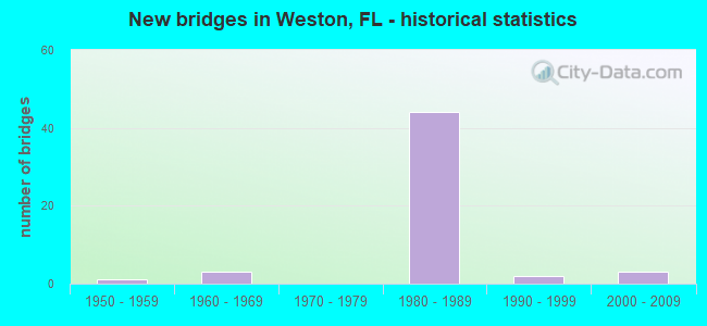
- New bridges - historical statistics
- 11950-1959
- 31960-1969
- 441980-1989
- 21990-1999
- 32000-2009
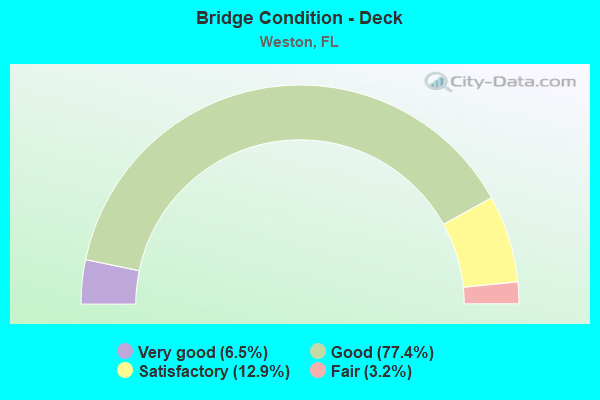
- Bridge Condition - Deck
- 6.5%Very good
- 77.4%Good
- 12.9%Satisfactory
- 3.2%Fair
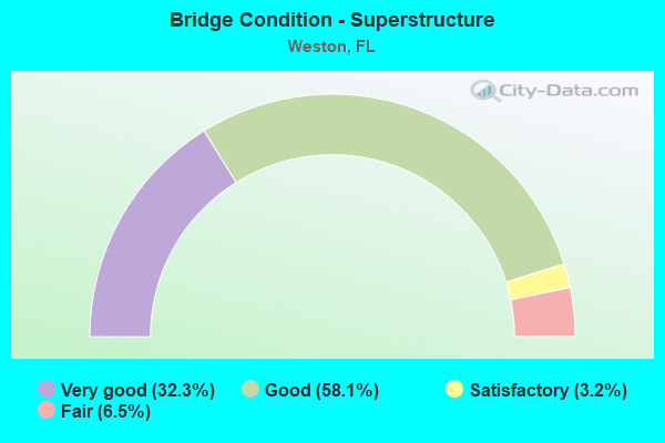
- Bridge Condition - Superstructure
- 32.3%Very good
- 58.1%Good
- 3.2%Satisfactory
- 6.5%Fair
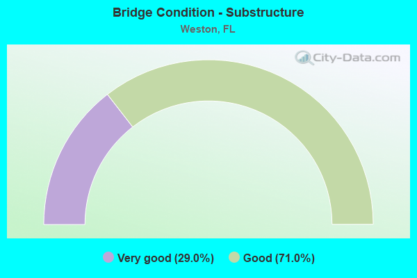
- Bridge Condition - Substructure
- 29.0%Very good
- 71.0%Good
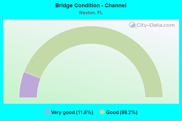
- Bridge Condition - Channel
- 11.8%Very good
- 88.2%Good
Find on map >> Show street view
Structure Number: 860019, Location: 2.2 Miles North of I-75 (Lat: 26.176964, Lng: -80.448789), Route carried "on" structure: US 27, Year Built: 1954, Year Reconstructed: 1980, Status: Open, Structure Length: 3.58m (11.75ft), Average Daily Traffic: 4,450 (year 2020), Truck Traffic: 33%, Average Future Daily Traffic: 7,721 (year 2042), Design Load: HS 20, Features Intersected: Canal S-11A
Minimum Vertical Clearance: 30+ m (98+ ft), Kilometerpoint: 24.502, Lanes on structure: 3, Base Highway Network: Yes, Owner: State Highway Agency, Approaching Roadway Width: 16.4m (53.8ft), Material/Design: Concrete, Design/Construction: Slab, Number Of Spans In Main Unit: 4, Length of Maximum Span: 9.1m (29.9ft), Curb-To-Curb Width: 16.4m (53.8ft), Out-to-Out Width: 17.2m (56.4ft)
Condition: Deck: Good, Superstructure: Good, Substructure: Good, Channel: Very good, Operating Rating: 46.9 metric tons, Method Used To Determine Operating Rating: Load Factor (LF), Inventory Rating: 28.1 metric tons, Method Used To Determine Inventory Rating: Load Factor (LF), Structural Evaluation: Better than present minimum criteria, Deck Geometry: Better than present minimum criteria, Waterway Adequacy: Superior to present desirable criteria, Approach Roadway Alignment: Equal to present desirable criteria, Designated Inspection Frequency: Every 24 months, Underwater Inspection Frequency: Every 24 months, Inspection Date: July 2021, Underwater Inspection Date: July 2021, Deck Structure Type: Concrete Cast-file-Place, Wearing Surface/Protective System: Wearing Surface: Bituminous
Find on map >> Show street view
Structure Number: 860057, Location: 3.2 Miles West of US-27 (Lat: 26.145917, Lng: -80.492611), Route carried "on" structure: Interstate 75, Year Built: 1967, Year Reconstructed: 1989, Status: Open, Structure Length: 3.66m (12.01ft), Average Daily Traffic: 12,478 (year 2020), Truck Traffic: 14%, Average Future Daily Traffic: 21,649 (year 2042), Design Load: HS 20+Mod, Features Intersected: Drainage Canal
Minimum Vertical Clearance: 30+ m (98+ ft), Kilometerpoint: 34.057, Lanes on structure: 2, Base Highway Network: Yes, Toll: On Interstate toll segment, Owner: State Highway Agency, Approaching Roadway Width: 13.7m (44.9ft), Material/Design: Concrete continuous, Design/Construction: Slab, Number Of Spans In Main Unit: 3, Length of Maximum Span: 12.2m (40.0ft), Curb-To-Curb Width: 12.2m (40.0ft), Out-to-Out Width: 13.0m (42.7ft)
Condition: Deck: Good, Superstructure: Good, Substructure: Good, Channel: Good, Operating Rating: 52.1 metric tons, Method Used To Determine Operating Rating: Load Factor (LF), Inventory Rating: 31.3 metric tons, Method Used To Determine Inventory Rating: Load Factor (LF), Structural Evaluation: Better than present minimum criteria, Deck Geometry: Better than present minimum criteria, Waterway Adequacy: Equal to present desirable criteria, Approach Roadway Alignment: Equal to present desirable criteria, Designated Inspection Frequency: Every 24 months, Underwater Inspection Frequency: Every 24 months, Inspection Date: July 2021, Underwater Inspection Date: July 2021, Deck Structure Type: Concrete Cast-file-Place, Wearing Surface/Protective System: Wearing Surface: Bituminous
Find on map >> Show street view
Structure Number: 860058, Location: 2.2 Miles West of US-27 (Lat: 26.145892, Lng: -80.476967), Route carried "on" structure: Interstate 75, Year Built: 1967, Year Reconstructed: 1989, Status: Open, Structure Length: 3.66m (12.01ft), Average Daily Traffic: 12,478 (year 2020), Truck Traffic: 14%, Average Future Daily Traffic: 21,649 (year 2042), Design Load: HS 20+Mod, Features Intersected: Drainage Canal
Minimum Vertical Clearance: 30+ m (98+ ft), Kilometerpoint: 32.501, Lanes on structure: 2, Base Highway Network: Yes, Toll: On Interstate toll segment, Owner: State Highway Agency, Approaching Roadway Width: 12.4m (40.7ft), Material/Design: Concrete continuous, Design/Construction: Slab, Number Of Spans In Main Unit: 3, Length of Maximum Span: 12.2m (40.0ft), Curb-To-Curb Width: 12.4m (40.7ft), Out-to-Out Width: 13.0m (42.7ft)
Condition: Deck: Good, Superstructure: Good, Substructure: Good, Channel: Good, Operating Rating: 52.1 metric tons, Method Used To Determine Operating Rating: Load Factor (LF), Inventory Rating: 31.3 metric tons, Method Used To Determine Inventory Rating: Load Factor (LF), Structural Evaluation: Better than present minimum criteria, Deck Geometry: Better than present minimum criteria, Waterway Adequacy: Equal to present desirable criteria, Approach Roadway Alignment: Equal to present desirable criteria, Designated Inspection Frequency: Every 24 months, Underwater Inspection Frequency: Every 24 months, Inspection Date: July 2021, Underwater Inspection Date: July 2021, Deck Structure Type: Concrete Cast-file-Place, Wearing Surface/Protective System: Wearing Surface: Bituminous
Find on map >> Show street view
Structure Number: 860059, Location: 1.2 Miles West of US-27 (Lat: 26.145844, Lng: -80.461253), Route carried "on" structure: Interstate 75, Year Built: 1967, Year Reconstructed: 1989, Status: Open, Structure Length: 3.66m (12.01ft), Average Daily Traffic: 12,478 (year 2020), Truck Traffic: 14%, Average Future Daily Traffic: 21,649 (year 2042), Design Load: HS 20+Mod, Features Intersected: Drainage Canal
Minimum Vertical Clearance: 30+ m (98+ ft), Kilometerpoint: 30.915, Lanes on structure: 2, Base Highway Network: Yes, Toll: On Interstate toll segment, Owner: State Highway Agency, Approaching Roadway Width: 13.7m (44.9ft), Material/Design: Concrete continuous, Design/Construction: Slab, Number Of Spans In Main Unit: 3, Length of Maximum Span: 12.2m (40.0ft), Curb-To-Curb Width: 12.2m (40.0ft), Out-to-Out Width: 13.0m (42.7ft)
Condition: Deck: Good, Superstructure: Good, Substructure: Good, Channel: Good, Operating Rating: 52.1 metric tons, Method Used To Determine Operating Rating: Load Factor (LF), Inventory Rating: 31.3 metric tons, Method Used To Determine Inventory Rating: Load Factor (LF), Structural Evaluation: Better than present minimum criteria, Deck Geometry: Better than present minimum criteria, Waterway Adequacy: Equal to present desirable criteria, Approach Roadway Alignment: Equal to present desirable criteria, Designated Inspection Frequency: Every 24 months, Underwater Inspection Frequency: Every 24 months, Inspection Date: July 2021, Underwater Inspection Date: July 2021, Deck Structure Type: Concrete Cast-file-Place, Wearing Surface/Protective System: Wearing Surface: Bituminous
Find on map >> Show street view
Structure Number: 860247, Location: 2.2 Miles North of I-75 (Lat: 26.176922, Lng: -80.449072), Route carried "on" structure: US 27, Year Built: 1980, Status: Open, Structure Length: 3.58m (11.75ft), Average Daily Traffic: 4,450 (year 2020), Truck Traffic: 33%, Average Future Daily Traffic: 7,721 (year 2042), Design Load: HS 20, Features Intersected: Canal S-11-A
Minimum Vertical Clearance: 30+ m (98+ ft), Kilometerpoint: 24.542, Lanes on structure: 3, Base Highway Network: Yes, Owner: State Highway Agency, Approaching Roadway Width: 15.8m (51.8ft), Material/Design: Prestressed concrete, Design/Construction: Slab, Number Of Spans In Main Unit: 4, Length of Maximum Span: 9.1m (29.9ft), Curb-To-Curb Width: 15.8m (51.8ft), Out-to-Out Width: 16.6m (54.5ft)
Condition: Deck: Good, Superstructure: Good, Substructure: Good, Channel: Very good, Operating Rating: 64.9 metric tons, Method Used To Determine Operating Rating: Load Factor (LF), Inventory Rating: 46.3 metric tons, Method Used To Determine Inventory Rating: Load Factor (LF), Structural Evaluation: Better than present minimum criteria, Deck Geometry: Better than present minimum criteria, Waterway Adequacy: Superior to present desirable criteria, Approach Roadway Alignment: Equal to present desirable criteria, Designated Inspection Frequency: Every 24 months, Underwater Inspection Frequency: Every 24 months, Inspection Date: July 2021, Underwater Inspection Date: July 2021, Deck Structure Type: Concrete Precast Panels, Wearing Surface/Protective System: Wearing Surface: Bituminous
Find on map >> Show street view
Structure Number: 860304, Location: 1.2 MI EAST OF US-27 (Lat: 26.140094, Lng: -80.419417), Route carried "on" structure: Interstate 75, Year Built: 1980, Status: Open, Structure Length: 5.32m (17.45ft), Average Daily Traffic: 14,500 (year 2020), Truck Traffic: 26%, Average Future Daily Traffic: 25,158 (year 2042), Design Load: HS 20, Features Intersected: GLADES PKWY (NW 196 AVE)
Minimum Vertical Clearance: 30+ m (98+ ft), Kilometerpoint: 26.715, Lanes on structure: 3, Lanes under structure: 4, Base Highway Network: Yes, Owner: State Highway Agency, Approaching Roadway Width: 17.3m (56.8ft), Material/Design: Prestressed concrete, Design/Construction: Stringer/Multi-beam, Number Of Spans In Main Unit: 3, Length of Maximum Span: 31.5m (103.3ft), Curb-To-Curb Width: 17.3m (56.8ft), Out-to-Out Width: 18.2m (59.7ft)
Condition: Deck: Satisfactory, Superstructure: Good, Substructure: Very good, Operating Rating: 62.9 metric tons, Method Used To Determine Operating Rating: Load Factor (LF), Inventory Rating: 37.7 metric tons, Method Used To Determine Inventory Rating: Load Factor (LF), Structural Evaluation: Better than present minimum criteria, Deck Geometry: Better than present minimum criteria, Underclear: Equal to present minimum criteria, Approach Roadway Alignment: Equal to present desirable criteria, Designated Inspection Frequency: Every 24 months, Inspection Date: September 2020, Deck Structure Type: Concrete Precast Panels
Find on map >> Show street view
Structure Number: 860305, Location: 1.2 MI EAST OF US-27 (Lat: 26.139814, Lng: -80.419497), Route carried "on" structure: Interstate 75, Year Built: 1980, Status: Open, Structure Length: 5.32m (17.45ft), Average Daily Traffic: 14,500 (year 2020), Truck Traffic: 26%, Average Future Daily Traffic: 25,158 (year 2042), Design Load: HS 20, Features Intersected: GLADES PKWY (NW 196 AVE)
Minimum Vertical Clearance: 30+ m (98+ ft), Kilometerpoint: 26.715, Lanes on structure: 3, Lanes under structure: 4, Base Highway Network: Yes, Owner: State Highway Agency, Approaching Roadway Width: 17.2m (56.4ft), Material/Design: Prestressed concrete, Design/Construction: Stringer/Multi-beam, Number Of Spans In Main Unit: 3, Length of Maximum Span: 31.5m (103.3ft), Curb-To-Curb Width: 17.2m (56.4ft), Out-to-Out Width: 18.1m (59.4ft)
Condition: Deck: Fair, Superstructure: Very good, Substructure: Very good, Operating Rating: 62.9 metric tons, Method Used To Determine Operating Rating: Load Factor (LF), Inventory Rating: 37.7 metric tons, Method Used To Determine Inventory Rating: Load Factor (LF), Structural Evaluation: Equal to present desirable criteria, Deck Geometry: Better than present minimum criteria, Underclear: Equal to present minimum criteria, Approach Roadway Alignment: Equal to present desirable criteria, Designated Inspection Frequency: Every 24 months, Inspection Date: September 2020, Deck Structure Type: Concrete Precast Panels
Find on map >> Show street view
Structure Number: 860333, Location: ANDYTOWN I-75 AND US-27 (Lat: 26.144669, Lng: -80.441861), Route carried "on" structure: Interstate 75, Year Built: 1982, Status: Open, Structure Length: 7.83m (25.69ft), Average Daily Traffic: 12,478 (year 2020), Truck Traffic: 14%, Average Future Daily Traffic: 21,649 (year 2042), Design Load: HS 20+Mod, Features Intersected: US-27 (SR-25)
Minimum Vertical Clearance: 30+ m (98+ ft), Kilometerpoint: 28.967, Lanes on structure: 2, Lanes under structure: 6, Base Highway Network: Yes, Owner: State Highway Agency, Approaching Roadway Width: 12.1m (39.7ft), Skew: 2 degrees, Material/Design: Prestressed concrete, Design/Construction: Stringer/Multi-beam, Number Of Spans In Main Unit: 4, Length of Maximum Span: 29.0m (95.1ft), Curb-To-Curb Width: 12.1m (39.7ft), Out-to-Out Width: 13.0m (42.7ft)
Condition: Deck: Satisfactory, Superstructure: Good, Substructure: Good, Operating Rating: 54.4 metric tons, Method Used To Determine Operating Rating: Load Testing, Inventory Rating: 32.7 metric tons, Method Used To Determine Inventory Rating: Load Testing, Structural Evaluation: Better than present minimum criteria, Deck Geometry: Equal to present minimum criteria, Underclear: Better than present minimum criteria, Approach Roadway Alignment: Equal to present desirable criteria, Designated Inspection Frequency: Every 24 months, Inspection Date: September 2020, Deck Structure Type: Concrete Precast Panels
Find on map >> Show street view
Structure Number: 860334, Location: ANDYTOWN I-75 AND US-27 (Lat: 26.144356, Lng: -80.441800), Route carried "on" structure: Interstate 75, Year Built: 1982, Status: Open, Structure Length: 7.83m (25.69ft), Average Daily Traffic: 12,478 (year 2020), Truck Traffic: 14%, Average Future Daily Traffic: 21,649 (year 2042), Design Load: HS 20+Mod, Features Intersected: US-27 (SR-25)
Minimum Vertical Clearance: 30+ m (98+ ft), Kilometerpoint: 28.957, Lanes on structure: 2, Lanes under structure: 6, Base Highway Network: Yes, Owner: State Highway Agency, Approaching Roadway Width: 11.9m (39.0ft), Skew: 2 degrees, Material/Design: Prestressed concrete, Design/Construction: Stringer/Multi-beam, Number Of Spans In Main Unit: 4, Length of Maximum Span: 29.0m (95.1ft), Curb-To-Curb Width: 11.9m (39.0ft), Out-to-Out Width: 13.0m (42.7ft)
Condition: Deck: Good, Superstructure: Good, Substructure: Good, Operating Rating: 54.4 metric tons, Method Used To Determine Operating Rating: Load Testing, Inventory Rating: 32.7 metric tons, Method Used To Determine Inventory Rating: Load Testing, Structural Evaluation: Better than present minimum criteria, Deck Geometry: Equal to present minimum criteria, Underclear: Better than present minimum criteria, Approach Roadway Alignment: Equal to present desirable criteria, Designated Inspection Frequency: Every 24 months, Inspection Date: September 2020, Deck Structure Type: Concrete Cast-file-Place
Find on map >> Show street view
Structure Number: 860335, Location: ANDYTOWN I-75 AND US-27 (Lat: 26.145072, Lng: -80.441986), Route carried "on" structure: Ramp Interstate 75, Year Built: 1982, Status: Open, Structure Length: 8.41m (27.59ft), Average Daily Traffic: 1,100 (year 2020), Truck Traffic: 25%, Average Future Daily Traffic: 1,908 (year 2042), Design Load: HS 20+Mod, Features Intersected: US-27 (SR-25), Facility Carried by Structure: RAMP G-H OVER US27
Minimum Vertical Clearance: 30+ m (98+ ft), Kilometerpoint: 0.618, Lanes on structure: 3, Lanes under structure: 6, Owner: State Highway Agency, Approaching Roadway Width: 18.4m (60.4ft), Skew: 31 degrees, Material/Design: Prestressed concrete, Design/Construction: Stringer/Multi-beam, Number Of Spans In Main Unit: 4, Length of Maximum Span: 28.3m (92.8ft), Curb-To-Curb Width: 19.2m (63.0ft), Out-to-Out Width: 20.6m (67.6ft)
Condition: Deck: Satisfactory, Superstructure: Very good, Substructure: Very good, Operating Rating: 55.7 metric tons, Method Used To Determine Operating Rating: Load Factor (LF), Inventory Rating: 36.9 metric tons, Method Used To Determine Inventory Rating: Load Factor (LF), Structural Evaluation: Equal to present desirable criteria, Deck Geometry: Superior to present desirable criteria, Underclear: Better than present minimum criteria, Approach Roadway Alignment: Equal to present desirable criteria, Designated Inspection Frequency: Every 24 months, Inspection Date: September 2020, Deck Structure Type: Concrete Precast Panels
Find on map >> Show street view
Structure Number: 860336, Location: ANDYTOWN I-75 AND US-27 (Lat: 26.143956, Lng: -80.441689), Route carried "on" structure: Ramp Interstate 75, Year Built: 1982, Status: Open, Structure Length: 8.41m (27.59ft), Average Daily Traffic: 2,700 (year 2020), Truck Traffic: 25%, Average Future Daily Traffic: 4,684 (year 2042), Design Load: HS 20+Mod, Features Intersected: US-27 (SR-25), Facility Carried by Structure: RAMP E-F OVER US27
Minimum Vertical Clearance: 30+ m (98+ ft), Kilometerpoint: 0.615, Lanes on structure: 3, Lanes under structure: 6, Owner: State Highway Agency, Approaching Roadway Width: 17.8m (58.4ft), Skew: 31 degrees, Material/Design: Prestressed concrete, Design/Construction: Stringer/Multi-beam, Number Of Spans In Main Unit: 4, Length of Maximum Span: 28.3m (92.8ft), Curb-To-Curb Width: 19.1m (62.7ft), Out-to-Out Width: 20.6m (67.6ft)
Condition: Deck: Satisfactory, Superstructure: Very good, Substructure: Very good, Operating Rating: 55.5 metric tons, Method Used To Determine Operating Rating: Load Factor (LF), Inventory Rating: 36.7 metric tons, Method Used To Determine Inventory Rating: Load Factor (LF), Structural Evaluation: Equal to present desirable criteria, Deck Geometry: Superior to present desirable criteria, Underclear: Better than present minimum criteria, Approach Roadway Alignment: Equal to present desirable criteria, Designated Inspection Frequency: Every 24 months, Inspection Date: September 2020, Deck Structure Type: Concrete Precast Panels
Find on map >> Show street view
Structure Number: 860337, Location: US-27 & I-75 INTERCHANGE (Lat: 26.144892, Lng: -80.444308), Route carried "on" structure: Ramp US 27, Year Built: 1982, Status: Open, Structure Length: 13.37m (43.86ft), Average Daily Traffic: 2,700 (year 2020), Truck Traffic: 25%, Average Future Daily Traffic: 4,684 (year 2042), Design Load: HS 20, Features Intersected: I-75 & S-W CONNECTOR
Minimum Vertical Clearance: 30+ m (98+ ft), Kilometerpoint: 0.303, Lanes on structure: 2, Lanes under structure: 6, Owner: State Highway Agency, Approaching Roadway Width: 12.1m (39.7ft), Skew: 9 degrees, Material/Design: Steel continuous, Design/Construction: Box Beam or Girders - Single/Spread, Number Of Spans In Main Unit: 2, Length of Maximum Span: 68.6m (225.1ft), Curb-To-Curb Width: 12.1m (39.7ft), Out-to-Out Width: 13.0m (42.7ft)
Condition: Deck: Good, Superstructure: Fair, Substructure: Good, Operating Rating: 62.1 metric tons, Method Used To Determine Operating Rating: Load Testing, Inventory Rating: 37.6 metric tons, Method Used To Determine Inventory Rating: Load Testing, Structural Evaluation: Somewhat better than minimum adequacy, Deck Geometry: Superior to present desirable criteria, Underclear: Somewhat better than minimum adequacy, Approach Roadway Alignment: Equal to present desirable criteria, Designated Inspection Frequency: Every 24 months, Critical Feature Inspection Frequency: Every 24 months, Inspection Date: October 2020, Critical Feature Inspection Date: October 2020, Deck Structure Type: Concrete Cast-file-Place
Find on map >> Show street view
Structure Number: 860338, Location: US-27 & I-75 INTERCHANGE (Lat: 26.144136, Lng: -80.439394), Route carried "on" structure: Ramp US 27, Year Built: 1982, Status: Open, Structure Length: 13.37m (43.86ft), Average Daily Traffic: 1,100 (year 2020), Truck Traffic: 25%, Average Future Daily Traffic: 1,908 (year 2042), Design Load: HS 20, Features Intersected: I-75 & N-E CONNECTOR
Minimum Vertical Clearance: 30+ m (98+ ft), Kilometerpoint: 0.304, Lanes on structure: 2, Lanes under structure: 6, Owner: State Highway Agency, Approaching Roadway Width: 9.5m (31.2ft), Skew: 9 degrees, Material/Design: Steel continuous, Design/Construction: Box Beam or Girders - Single/Spread, Number Of Spans In Main Unit: 2, Length of Maximum Span: 68.6m (225.1ft), Curb-To-Curb Width: 12.1m (39.7ft), Out-to-Out Width: 13.0m (42.7ft)
Condition: Deck: Good, Superstructure: Fair, Substructure: Good, Operating Rating: 65.3 metric tons, Method Used To Determine Operating Rating: Load Testing, Inventory Rating: 39.2 metric tons, Method Used To Determine Inventory Rating: Load Testing, Structural Evaluation: Somewhat better than minimum adequacy, Deck Geometry: Superior to present desirable criteria, Underclear: Somewhat better than minimum adequacy, Approach Roadway Alignment: Equal to present desirable criteria, Designated Inspection Frequency: Every 24 months, Critical Feature Inspection Frequency: Every 24 months, Inspection Date: October 2020, Critical Feature Inspection Date: October 2020, Deck Structure Type: Concrete Cast-file-Place
Find on map >> Show street view
Structure Number: 860341, Location: 2MI S OF I-595&I-75 INTER (Lat: 26.087744, Lng: -80.363328), Route carried "on" structure: City street , Year Built: 1984, Status: Open, Structure Length: 12.47m (40.91ft), Average Daily Traffic: 54,500 (year 2020), Truck Traffic: 7%, Average Future Daily Traffic: 94,558 (year 2042), Design Load: HS 20+Mod, Features Intersected: I-75 (SR-93), Facility Carried by Structure: ROYAL PALM BLVD.
Minimum Vertical Clearance: 30+ m (98+ ft), Kilometerpoint: 5.644, Lanes on structure: 4, Lanes under structure: 15, Owner: State Highway Agency, Approaching Roadway Width: 30.0m (98.4ft), Skew: 20 degrees, Material/Design: Prestressed concrete, Design/Construction: Stringer/Multi-beam, Number Of Spans In Main Unit: 5, Length of Maximum Span: 38.1m (125.0ft), Curb-To-Curb Width: 33.8m (110.9ft), Out-to-Out Width: 39.6m (129.9ft)
Condition: Deck: Good, Superstructure: Satisfactory, Substructure: Good, Operating Rating: 27.4 metric tons, Method Used To Determine Operating Rating: Load and Resistance Factor (LRFR), Inventory Rating: 17.3 metric tons, Method Used To Determine Inventory Rating: Load and Resistance Factor (LRFR), Structural Evaluation: Meets minimum limits, Deck Geometry: Superior to present desirable criteria, Underclear: Meets minimum limits, Approach Roadway Alignment: Better than present minimum criteria, Designated Inspection Frequency: Every 24 months, Inspection Date: September 2020, Deck Structure Type: Concrete Cast-file-Place
Find on map >> Show street view
Structure Number: 860342, Location: 2.6 MI E of US-27 (Lat: 26.135522, Lng: -80.400539), Route carried "on" structure: Interstate 75, Year Built: 1983, Status: Open, Structure Length: 5.46m (17.91ft), Average Daily Traffic: 26,250 (year 2020), Truck Traffic: 7%, Average Future Daily Traffic: 45,544 (year 2042), Design Load: HS 20+Mod, Features Intersected: INDIAN TRACE (184TH AVE)
Minimum Vertical Clearance: 30+ m (98+ ft), Kilometerpoint: 24.763, Lanes on structure: 3, Lanes under structure: 4, Base Highway Network: Yes, Owner: State Highway Agency, Approaching Roadway Width: 17.6m (57.7ft), Material/Design: Prestressed concrete, Design/Construction: Stringer/Multi-beam, Number Of Spans In Main Unit: 3, Length of Maximum Span: 31.4m (103.0ft), Curb-To-Curb Width: 17.0m (55.8ft), Out-to-Out Width: 17.9m (58.7ft)
Condition: Deck: Good, Superstructure: Very good, Substructure: Very good, Operating Rating: 53.0 metric tons, Method Used To Determine Operating Rating: Load Factor (LF), Inventory Rating: 43.9 metric tons, Method Used To Determine Inventory Rating: Load Factor (LF), Structural Evaluation: Equal to present desirable criteria, Deck Geometry: Equal to present minimum criteria, Underclear: Equal to present minimum criteria, Approach Roadway Alignment: Equal to present desirable criteria, Designated Inspection Frequency: Every 24 months, Inspection Date: September 2020, Deck Structure Type: Concrete Cast-file-Place
Find on map >> Show street view
Structure Number: 860343, Location: 2.6 MI E OF US-27 (Lat: 26.135250, Lng: -80.400619), Route carried "on" structure: Interstate 75, Year Built: 1983, Status: Open, Structure Length: 5.46m (17.91ft), Average Daily Traffic: 26,250 (year 2020), Truck Traffic: 7%, Average Future Daily Traffic: 45,544 (year 2042), Design Load: HS 20+Mod, Features Intersected: INDIAN TRACE (184TH AVE)
Minimum Vertical Clearance: 30+ m (98+ ft), Kilometerpoint: 24.763, Lanes on structure: 3, Lanes under structure: 4, Base Highway Network: Yes, Owner: State Highway Agency, Approaching Roadway Width: 17.1m (56.1ft), Material/Design: Prestressed concrete, Design/Construction: Stringer/Multi-beam, Number Of Spans In Main Unit: 3, Length of Maximum Span: 31.4m (103.0ft), Curb-To-Curb Width: 17.0m (55.8ft), Out-to-Out Width: 17.9m (58.7ft)
Condition: Deck: Good, Superstructure: Very good, Substructure: Very good, Operating Rating: 53.0 metric tons, Method Used To Determine Operating Rating: Load Factor (LF), Inventory Rating: 43.9 metric tons, Method Used To Determine Inventory Rating: Load Factor (LF), Structural Evaluation: Equal to present desirable criteria, Deck Geometry: Equal to present minimum criteria, Underclear: Equal to present minimum criteria, Approach Roadway Alignment: Equal to present desirable criteria, Designated Inspection Frequency: Every 24 months, Inspection Date: September 2020, Deck Structure Type: Concrete Cast-file-Place
Find on map >> Show street view
Structure Number: 860344, Location: 4.7 MI EAST OF US-27 (Lat: 26.127883, Lng: -80.368611), Route carried "on" structure: Interstate 75, Year Built: 1983, Status: Open, Structure Length: 7.47m (24.51ft), Average Daily Traffic: 26,250 (year 2020), Truck Traffic: 7%, Average Future Daily Traffic: 45,544 (year 2042), Design Load: HS 20, Features Intersected: BONAVENTURE BLVD
Minimum Vertical Clearance: 30+ m (98+ ft), Kilometerpoint: 21.446, Lanes on structure: 5, Lanes under structure: 5, Base Highway Network: Yes, Owner: State Highway Agency, Approaching Roadway Width: 24.3m (79.7ft), Material/Design: Prestressed concrete, Design/Construction: Stringer/Multi-beam, Number Of Spans In Main Unit: 3, Length of Maximum Span: 30.2m (99.1ft), Curb-To-Curb Width: 24.3m (79.7ft), Out-to-Out Width: 25.2m (82.7ft)
Condition: Deck: Good, Superstructure: Good, Substructure: Good, Inventory Rating: 56.3 metric tons, Method Used To Determine Inventory Rating: Load Factor (LF), Structural Evaluation: Better than present minimum criteria, Deck Geometry: Equal to present minimum criteria, Underclear: Equal to present minimum criteria, Approach Roadway Alignment: Equal to present desirable criteria, Designated Inspection Frequency: Every 24 months, Inspection Date: September 2020, Deck Structure Type: Concrete Cast-file-Place
Find on map >> Show street view
Structure Number: 860345, Location: 4.7 MI EAST OF US-27 (Lat: 26.127542, Lng: -80.368708), Route carried "on" structure: Interstate 75, Year Built: 1983, Status: Open, Structure Length: 7.47m (24.51ft), Average Daily Traffic: 26,250 (year 2020), Truck Traffic: 7%, Average Future Daily Traffic: 45,544 (year 2042), Design Load: HS 20, Features Intersected: BONAVENTURE BLVD
Minimum Vertical Clearance: 30+ m (98+ ft), Kilometerpoint: 21.446, Lanes on structure: 5, Lanes under structure: 5, Base Highway Network: Yes, Owner: State Highway Agency, Approaching Roadway Width: 24.3m (79.7ft), Material/Design: Prestressed concrete, Design/Construction: Stringer/Multi-beam, Number Of Spans In Main Unit: 3, Length of Maximum Span: 30.2m (99.1ft), Curb-To-Curb Width: 24.3m (79.7ft), Out-to-Out Width: 25.2m (82.7ft)
Condition: Deck: Very good, Superstructure: Very good, Substructure: Good, Inventory Rating: 56.3 metric tons, Method Used To Determine Inventory Rating: Load Factor (LF), Structural Evaluation: Better than present minimum criteria, Deck Geometry: Equal to present minimum criteria, Underclear: Equal to present minimum criteria, Approach Roadway Alignment: Equal to present desirable criteria, Designated Inspection Frequency: Every 24 months, Inspection Date: September 2020, Deck Structure Type: Concrete Cast-file-Place
Find on map >> Show street view
Structure Number: 860445, Location: 3.2 Miles West of US-27 (Lat: 26.146222, Lng: -80.492639), Route carried "on" structure: Interstate 75, Year Built: 1988, Status: Open, Structure Length: 3.66m (12.01ft), Average Daily Traffic: 12,478 (year 2020), Truck Traffic: 14%, Average Future Daily Traffic: 21,649 (year 2042), Design Load: HS 20+Mod, Features Intersected: Drainage Canal
Minimum Vertical Clearance: 30+ m (98+ ft), Kilometerpoint: 34.057, Lanes on structure: 2, Base Highway Network: Yes, Toll: On Interstate toll segment, Owner: State Highway Agency, Approaching Roadway Width: 13.7m (44.9ft), Material/Design: Concrete continuous, Design/Construction: Slab, Number Of Spans In Main Unit: 3, Length of Maximum Span: 12.2m (40.0ft), Curb-To-Curb Width: 12.1m (39.7ft), Out-to-Out Width: 13.0m (42.7ft)
Condition: Deck: Good, Superstructure: Good, Substructure: Good, Channel: Good, Operating Rating: 52.1 metric tons, Method Used To Determine Operating Rating: Load Factor (LF), Inventory Rating: 31.3 metric tons, Method Used To Determine Inventory Rating: Load Factor (LF), Structural Evaluation: Better than present minimum criteria, Deck Geometry: Equal to present minimum criteria, Waterway Adequacy: Equal to present desirable criteria, Approach Roadway Alignment: Equal to present desirable criteria, Designated Inspection Frequency: Every 24 months, Underwater Inspection Frequency: Every 24 months, Inspection Date: July 2021, Underwater Inspection Date: July 2021, Deck Structure Type: Concrete Cast-file-Place, Wearing Surface/Protective System: Wearing Surface: Bituminous
Find on map >> Show street view
Structure Number: 860446, Location: 2.2 Miles West of US-27 (Lat: 26.146208, Lng: -80.476964), Route carried "on" structure: Interstate 75, Year Built: 1988, Status: Open, Structure Length: 3.66m (12.01ft), Average Daily Traffic: 12,478 (year 2020), Truck Traffic: 14%, Average Future Daily Traffic: 21,649 (year 2042), Design Load: HS 20+Mod, Features Intersected: Drainage Canal
Minimum Vertical Clearance: 30+ m (98+ ft), Kilometerpoint: 32.501, Lanes on structure: 2, Base Highway Network: Yes, Toll: On Interstate toll segment, Owner: State Highway Agency, Approaching Roadway Width: 13.7m (44.9ft), Material/Design: Concrete continuous, Design/Construction: Slab, Number Of Spans In Main Unit: 3, Length of Maximum Span: 12.2m (40.0ft), Curb-To-Curb Width: 12.1m (39.7ft), Out-to-Out Width: 13.0m (42.7ft)
Condition: Deck: Good, Superstructure: Good, Substructure: Good, Channel: Good, Operating Rating: 52.1 metric tons, Method Used To Determine Operating Rating: Load Factor (LF), Inventory Rating: 31.3 metric tons, Method Used To Determine Inventory Rating: Load Factor (LF), Structural Evaluation: Better than present minimum criteria, Deck Geometry: Equal to present minimum criteria, Waterway Adequacy: Equal to present desirable criteria, Approach Roadway Alignment: Equal to present desirable criteria, Designated Inspection Frequency: Every 24 months, Underwater Inspection Frequency: Every 24 months, Inspection Date: July 2021, Underwater Inspection Date: July 2021, Deck Structure Type: Concrete Cast-file-Place, Wearing Surface/Protective System: Wearing Surface: Bituminous
Find on map >> Show street view
Structure Number: 860447, Location: 1.2 Miles West of US-27 (Lat: 26.146161, Lng: -80.461253), Route carried "on" structure: Interstate 75, Year Built: 1988, Status: Open, Structure Length: 3.66m (12.01ft), Average Daily Traffic: 12,478 (year 2020), Truck Traffic: 14%, Average Future Daily Traffic: 21,649 (year 2042), Design Load: HS 20+Mod, Features Intersected: Drainage Canal
Minimum Vertical Clearance: 30+ m (98+ ft), Kilometerpoint: 30.915, Lanes on structure: 2, Base Highway Network: Yes, Toll: On Interstate toll segment, Owner: State Highway Agency, Approaching Roadway Width: 13.5m (44.3ft), Material/Design: Concrete continuous, Design/Construction: Slab, Number Of Spans In Main Unit: 3, Length of Maximum Span: 12.2m (40.0ft), Curb-To-Curb Width: 12.1m (39.7ft), Out-to-Out Width: 13.0m (42.7ft)
Condition: Deck: Good, Superstructure: Good, Substructure: Good, Channel: Good, Operating Rating: 52.1 metric tons, Method Used To Determine Operating Rating: Load Factor (LF), Inventory Rating: 31.3 metric tons, Method Used To Determine Inventory Rating: Load Factor (LF), Structural Evaluation: Better than present minimum criteria, Deck Geometry: Equal to present minimum criteria, Waterway Adequacy: Equal to present desirable criteria, Approach Roadway Alignment: Equal to present desirable criteria, Designated Inspection Frequency: Every 24 months, Underwater Inspection Frequency: Every 24 months, Inspection Date: July 2021, Underwater Inspection Date: July 2021, Deck Structure Type: Concrete Cast-file-Place, Wearing Surface/Protective System: Wearing Surface: Bituminous
Find on map >> Show street view
Structure Number: 86064, Location: I-595 WB Ramp to SR-84 WB (Lat: 26.122889, Lng: -80.349694), Route carried "on" structure: Ramp Interstate 595, Year Built: 2008, Status: Open, Structure Length: 23.32m (76.51ft), Average Daily Traffic: 9,200 (year 2020), Truck Traffic: 3%, Average Future Daily Traffic: 15,962 (year 2042), Design Load: HL 93, Features Intersected: Retention Pond
Minimum Vertical Clearance: 30+ m (98+ ft), Kilometerpoint: 0.198, Lanes on structure: 1, Owner: State Highway Agency, Approaching Roadway Width: 8.2m (26.9ft), Skew: 9 degrees, Material/Design: Prestressed concrete, Design/Construction: Stringer/Multi-beam, Number Of Spans In Main Unit: 18, Length of Maximum Span: 13.0m (42.7ft), Curb-To-Curb Width: 8.2m (26.9ft), Out-to-Out Width: 9.2m (30.2ft)
Condition: Deck: Good, Superstructure: Good, Substructure: Good, Channel: Good, Operating Rating: 43.7 metric tons, Method Used To Determine Operating Rating: Load and Resistance Factor (LRFR), Inventory Rating: 39.2 metric tons, Method Used To Determine Inventory Rating: Load and Resistance Factor (LRFR), Structural Evaluation: Better than present minimum criteria, Deck Geometry: Superior to present desirable criteria, Waterway Adequacy: Equal to present desirable criteria, Approach Roadway Alignment: Better than present minimum criteria, Designated Inspection Frequency: Every 24 months, Underwater Inspection Frequency: Every 24 months, Inspection Date: March 2021, Underwater Inspection Date: March 2021, Deck Structure Type: Concrete Cast-file-Place
Find on map >> Show street view
Structure Number: 860641, Location: NB I75 Ramp From SR869 SB (Lat: 26.121861, Lng: -80.348528), Route carried "on" structure: Ramp Interstate 75, Year Built: 2008, Status: Open, Structure Length: 1.94m (6.36ft), Average Daily Traffic: 7,800 (year 2020), Truck Traffic: 8%, Average Future Daily Traffic: 13,533 (year 2042), Design Load: HL 93, Features Intersected: I-595 WB Ramp
Minimum Vertical Clearance: 30+ m (98+ ft), Kilometerpoint: 0.436, Lanes on structure: 1, Lanes under structure: 1, Owner: State Highway Agency, Approaching Roadway Width: 12.2m (40.0ft), Skew: 4 degrees, Material/Design: Prestressed concrete, Design/Construction: Slab, Number Of Spans In Main Unit: 1, Length of Maximum Span: 19.4m (63.6ft), Curb-To-Curb Width: 12.2m (40.0ft), Out-to-Out Width: 13.3m (43.6ft)
Condition: Deck: Good, Superstructure: Good, Substructure: Good, Operating Rating: 41.5 metric tons, Method Used To Determine Operating Rating: Load and Resistance Factor (LRFR), Inventory Rating: 34.9 metric tons, Method Used To Determine Inventory Rating: Load and Resistance Factor (LRFR), Structural Evaluation: Better than present minimum criteria, Deck Geometry: Superior to present desirable criteria, Underclear: Somewhat better than minimum adequacy, Approach Roadway Alignment: Better than present minimum criteria, Designated Inspection Frequency: Every 24 months, Inspection Date: March 2021, Deck Structure Type: Concrete Precast Panels, Wearing Surface/Protective System: Wearing Surface: Integral Concrete
Find on map >> Show street view
Structure Number: 86405, Location: 0.5MI W OF I-75 (Lat: 26.087764, Lng: -80.374722), Route carried "on" structure: County highway , Year Built: 1982, Status: Open, Structure Length: 0.94m (3.08ft), Average Daily Traffic: 7,500 (year 2021), Truck Traffic: 2%, Average Future Daily Traffic: 8,000 (year 2042), Design Load: H 20, Features Intersected: CLAYTON CANAL, Facility Carried by Structure: ROYAL PLM BLVD(EB)
Minimum Vertical Clearance: 30+ m (98+ ft), Kilometerpoint: 4.559, Lanes on structure: 2, Owner: City or Municipal Highway Agency, Approaching Roadway Width: 9.8m (32.2ft), Material/Design: Prestressed concrete, Design/Construction: Slab, Number Of Spans In Main Unit: 1, Length of Maximum Span: 9.4m (30.8ft), Curb or Sidewalk Widths: Left: 0.0m, Right: 4.3m (14.1ft), Curb-To-Curb Width: 9.8m (32.2ft), Out-to-Out Width: 15.1m (49.5ft)
Condition: Deck: Good, Superstructure: Very good, Substructure: Very good, Channel: Good, Operating Rating: 88.6 metric tons, Method Used To Determine Operating Rating: Load Factor (LF), Inventory Rating: 53.2 metric tons, Method Used To Determine Inventory Rating: Load Factor (LF), Structural Evaluation: Equal to present desirable criteria, Deck Geometry: Meets minimum limits, Waterway Adequacy: Equal to present desirable criteria, Approach Roadway Alignment: Better than present minimum criteria, Designated Inspection Frequency: Every 24 months, Underwater Inspection Frequency: Every 24 months, Inspection Date: January 2021, Underwater Inspection Date: January 2021, Deck Structure Type: Concrete Precast Panels, Wearing Surface/Protective System: Wearing Surface: Bituminous
Find on map >> Show street view
Structure Number: 864051, Location: 0.5MI W OF I-75 (Lat: 26.088067, Lng: -80.374625), Route carried "on" structure: County highway , Year Built: 1982, Status: Open, Structure Length: 0.94m (3.08ft), Average Daily Traffic: 7,500 (year 2021), Truck Traffic: 2%, Average Future Daily Traffic: 8,000 (year 2042), Design Load: H 20, Features Intersected: CLAYTON CANAL, Facility Carried by Structure: ROYAL PLM BLVD(WB)
Minimum Vertical Clearance: 30+ m (98+ ft), Kilometerpoint: 4.559, Lanes on structure: 2, Owner: City or Municipal Highway Agency, Approaching Roadway Width: 11.6m (38.1ft), Material/Design: Prestressed concrete, Design/Construction: Slab, Number Of Spans In Main Unit: 1, Length of Maximum Span: 9.4m (30.8ft), Curb or Sidewalk Widths: Left: 4.3m (14.1ft), Right: 0.0m, Curb-To-Curb Width: 10.1m (33.1ft), Out-to-Out Width: 15.1m (49.5ft)
Condition: Deck: Good, Superstructure: Good, Substructure: Good, Channel: Good, Operating Rating: 88.6 metric tons, Method Used To Determine Operating Rating: Load Factor (LF), Inventory Rating: 53.2 metric tons, Method Used To Determine Inventory Rating: Load Factor (LF), Structural Evaluation: Better than present minimum criteria, Deck Geometry: Somewhat better than minimum adequacy, Waterway Adequacy: Equal to present desirable criteria, Approach Roadway Alignment: Better than present minimum criteria, Designated Inspection Frequency: Every 24 months, Underwater Inspection Frequency: Every 24 months, Inspection Date: January 2021, Underwater Inspection Date: January 2021, Deck Structure Type: Concrete Precast Panels, Wearing Surface/Protective System: Wearing Surface: Bituminous
Find on map >> Show street view
Structure Number: 864092, Location: 2MI W OF I-75 (Lat: 26.096125, Lng: -80.388925), Route carried "on" structure: County highway , Year Built: 1988, Status: Open, Structure Length: 1.13m (3.71ft), Average Daily Traffic: 1,800 (year 2021), Truck Traffic: 5%, Average Future Daily Traffic: 2,160 (year 2042), Design Load: HS 20, Features Intersected: LAKE WESTON, Facility Carried by Structure: ROYAL PALM BLVD EB
Minimum Vertical Clearance: 30+ m (98+ ft), Kilometerpoint: 2.770, Lanes on structure: 2, Owner: City or Municipal Highway Agency, Approaching Roadway Width: 9.1m (29.9ft), Material/Design: Prestressed concrete, Design/Construction: Slab, Number Of Spans In Main Unit: 1, Length of Maximum Span: 11.3m (37.1ft), Curb or Sidewalk Widths: Left: 0.0m, Right: 1.5m (4.9ft), Curb-To-Curb Width: 12.8m (42.0ft), Out-to-Out Width: 15.1m (49.5ft)
Condition: Deck: Good, Superstructure: Very good, Substructure: Good, Channel: Good, Operating Rating: 52.6 metric tons, Method Used To Determine Operating Rating: Allowable Stress (AS), Inventory Rating: 39.5 metric tons, Method Used To Determine Inventory Rating: Allowable Stress (AS), Structural Evaluation: Better than present minimum criteria, Deck Geometry: Equal to present desirable criteria, Waterway Adequacy: Equal to present desirable criteria, Approach Roadway Alignment: Better than present minimum criteria, Designated Inspection Frequency: Every 24 months, Underwater Inspection Frequency: Every 24 months, Inspection Date: January 2021, Underwater Inspection Date: January 2021, Deck Structure Type: Concrete Precast Panels, Wearing Surface/Protective System: Wearing Surface: Bituminous
Find on map >> Show street view
Structure Number: 864093, Location: 2MI W OF I-75 (Lat: 26.096253, Lng: -80.388858), Route carried "on" structure: County highway , Year Built: 1988, Status: Open, Structure Length: 1.13m (3.71ft), Average Daily Traffic: 1,800 (year 2021), Truck Traffic: 5%, Average Future Daily Traffic: 2,160 (year 2042), Design Load: HS 20, Features Intersected: LAKE WESTON, Facility Carried by Structure: ROYAL PLM BLVD WB
Minimum Vertical Clearance: 30+ m (98+ ft), Kilometerpoint: 2.770, Lanes on structure: 2, Owner: City or Municipal Highway Agency, Approaching Roadway Width: 9.1m (29.9ft), Material/Design: Prestressed concrete, Design/Construction: Slab, Number Of Spans In Main Unit: 1, Length of Maximum Span: 11.3m (37.1ft), Curb or Sidewalk Widths: Left: 1.5m (4.9ft), Right: 0.0m, Curb-To-Curb Width: 12.8m (42.0ft), Out-to-Out Width: 15.1m (49.5ft)
Condition: Deck: Good, Superstructure: Very good, Substructure: Very good, Channel: Good, Operating Rating: 52.6 metric tons, Method Used To Determine Operating Rating: Allowable Stress (AS), Inventory Rating: 39.5 metric tons, Method Used To Determine Inventory Rating: Allowable Stress (AS), Structural Evaluation: Equal to present desirable criteria, Deck Geometry: Equal to present desirable criteria, Waterway Adequacy: Equal to present desirable criteria, Approach Roadway Alignment: Better than present minimum criteria, Designated Inspection Frequency: Every 24 months, Underwater Inspection Frequency: Every 24 months, Inspection Date: January 2021, Underwater Inspection Date: January 2021, Deck Structure Type: Concrete Precast Panels, Wearing Surface/Protective System: Wearing Surface: Bituminous
Find on map >> Show street view
Structure Number: 864094, Location: 1.4 MI W OF WESTON RD (Lat: 26.105408, Lng: -80.389181), Route carried "on" structure: City street , Year Built: 1988, Status: Open, Structure Length: 1.13m (3.71ft), Average Daily Traffic: 8,225 (year 2021), Truck Traffic: 3%, Average Future Daily Traffic: 14,270 (year 2042), Design Load: HS 20, Features Intersected: LAKE WESTON, Facility Carried by Structure: INDIAN TRACE (EB)
Minimum Vertical Clearance: 30+ m (98+ ft), Kilometerpoint: 1.448, Lanes on structure: 2, Owner: City or Municipal Highway Agency, Approaching Roadway Width: 9.1m (29.9ft), Material/Design: Prestressed concrete, Design/Construction: Slab, Number Of Spans In Main Unit: 1, Length of Maximum Span: 11.3m (37.1ft), Curb or Sidewalk Widths: Left: 0.0m, Right: 1.5m (4.9ft), Curb-To-Curb Width: 12.8m (42.0ft), Out-to-Out Width: 15.0m (49.2ft)
Condition: Deck: Good, Superstructure: Good, Substructure: Good, Channel: Good, Operating Rating: 41.7 metric tons, Method Used To Determine Operating Rating: Allowable Stress (AS), Inventory Rating: 37.2 metric tons, Method Used To Determine Inventory Rating: Allowable Stress (AS), Structural Evaluation: Better than present minimum criteria, Deck Geometry: Equal to present desirable criteria, Waterway Adequacy: Equal to present desirable criteria, Approach Roadway Alignment: Better than present minimum criteria, Designated Inspection Frequency: Every 24 months, Underwater Inspection Frequency: Every 24 months, Inspection Date: Febuary 2021, Underwater Inspection Date: Febuary 2021, Deck Structure Type: Concrete Precast Panels, Wearing Surface/Protective System: Wearing Surface: Bituminous
Find on map >> Show street view
Structure Number: 864095, Location: 1.4 MI W OF WESTON RD (Lat: 26.105558, Lng: -80.389081), Route carried "on" structure: County highway , Year Built: 1988, Status: Open, Structure Length: 1.13m (3.71ft), Average Daily Traffic: 8,225 (year 2021), Truck Traffic: 3%, Average Future Daily Traffic: 14,270 (year 2042), Design Load: HS 20, Features Intersected: LAKE WESTON, Facility Carried by Structure: INDIAN TRACE (WB)
Minimum Vertical Clearance: 30+ m (98+ ft), Kilometerpoint: 1.448, Lanes on structure: 2, Owner: City or Municipal Highway Agency, Approaching Roadway Width: 9.1m (29.9ft), Material/Design: Prestressed concrete, Design/Construction: Slab, Number Of Spans In Main Unit: 1, Length of Maximum Span: 11.3m (37.1ft), Curb or Sidewalk Widths: Left: 1.5m (4.9ft), Right: 0.0m, Curb-To-Curb Width: 12.8m (42.0ft), Out-to-Out Width: 15.0m (49.2ft)
Condition: Deck: Very good, Superstructure: Very good, Substructure: Good, Channel: Good, Operating Rating: 41.7 metric tons, Method Used To Determine Operating Rating: Allowable Stress (AS), Inventory Rating: 37.2 metric tons, Method Used To Determine Inventory Rating: Allowable Stress (AS), Structural Evaluation: Better than present minimum criteria, Deck Geometry: Equal to present desirable criteria, Approach Roadway Alignment: Better than present minimum criteria, Designated Inspection Frequency: Every 24 months, Underwater Inspection Frequency: Every 24 months, Inspection Date: Febuary 2021, Underwater Inspection Date: Febuary 2021, Deck Structure Type: Concrete Precast Panels, Wearing Surface/Protective System: Wearing Surface: Bituminous
Find on map >> Show street view
Structure Number: 864104, Location: AT GRIFFIN ROAD (Lat: 26.062256, Lng: -80.393686), Route carried "on" structure: City street , Year Built: 1993, Status: Open, Structure Length: 4.47m (14.67ft), Average Daily Traffic: 4,320 (year 2021), Truck Traffic: 5%, Average Future Daily Traffic: 5,184 (year 2042), Design Load: HS 20, Features Intersected: CANAL C-11, Facility Carried by Structure: BONAVENTURE BLVD.
Minimum Vertical Clearance: 30+ m (98+ ft), Kilometerpoint: 0.023, Lanes on structure: 5, Owner: City or Municipal Highway Agency, Approaching Roadway Width: 22.9m (75.1ft), Skew: 20 degrees, Material/Design: Prestressed concrete, Design/Construction: Slab, Number Of Spans In Main Unit: 3, Length of Maximum Span: 14.9m (48.9ft), Curb or Sidewalk Widths: Left: 1.5m (4.9ft), Right: 1.5m (4.9ft), Curb-To-Curb Width: 22.9m (75.1ft), Out-to-Out Width: 28.7m (94.2ft)
Condition: Deck: Good, Superstructure: Good, Substructure: Very good, Channel: Good, Operating Rating: 48.7 metric tons, Method Used To Determine Operating Rating: Load Factor (LF), Inventory Rating: 29.2 metric tons, Method Used To Determine Inventory Rating: Load Factor (LF), Structural Evaluation: Better than present minimum criteria, Deck Geometry: Equal to present minimum criteria, Waterway Adequacy: Equal to present desirable criteria, Approach Roadway Alignment: Equal to present desirable criteria, Designated Inspection Frequency: Every 24 months, Underwater Inspection Frequency: Every 24 months, Inspection Date: January 2021, Underwater Inspection Date: January 2021, Deck Structure Type: Concrete Precast Panels, Wearing Surface/Protective System: Wearing Surface: Bituminous
Find on map >> Show street view
Structure Number: 864108, Location: WESTON RD at GRIFFIN RD. (Lat: 26.062939, Lng: -80.362253), Route carried "on" structure: City street , Year Built: 1996, Status: Open, Structure Length: 3.66m (12.01ft), Average Daily Traffic: 18,162 (year 2021), Truck Traffic: 10%, Average Future Daily Traffic: 31,511 (year 2042), Design Load: HS 20+Mod, Features Intersected: C-11 CANAL S NEW RIVER, Facility Carried by Structure: WESTON ROAD
Minimum Vertical Clearance: 30+ m (98+ ft), Kilometerpoint: 0.029, Lanes on structure: 6, Owner: City or Municipal Highway Agency, Approaching Roadway Width: 23.5m (77.1ft), Material/Design: Prestressed concrete, Design/Construction: Slab, Number Of Spans In Main Unit: 3, Length of Maximum Span: 12.2m (40.0ft), Curb or Sidewalk Widths: Left: 1.5m (4.9ft), Right: 1.5m (4.9ft), Curb-To-Curb Width: 23.5m (77.1ft), Out-to-Out Width: 27.3m (89.6ft)
Condition: Deck: Good, Superstructure: Good, Substructure: Good, Channel: Good, Operating Rating: 75.9 metric tons, Method Used To Determine Operating Rating: Load Factor (LF), Inventory Rating: 45.5 metric tons, Method Used To Determine Inventory Rating: Load Factor (LF), Structural Evaluation: Better than present minimum criteria, Deck Geometry: Somewhat better than minimum adequacy, Waterway Adequacy: Equal to present desirable criteria, Approach Roadway Alignment: Equal to present desirable criteria, Designated Inspection Frequency: Every 24 months, Underwater Inspection Frequency: Every 24 months, Inspection Date: Febuary 2021, Underwater Inspection Date: Febuary 2021, Deck Structure Type: Concrete Precast Panels, Wearing Surface/Protective System: Wearing Surface: Bituminous
Find on map >> Show street view
Structure Number: 860304, Location: 1.2 MI EAST OF US-27 (Lat: 26.140094, Lng: -80.419417), Route carried "under" structure: City street , Year Built: 1980, Structure Length: 0. m, Average Daily Traffic: 11,550 (year 2020), Truck Traffic: 5%, Features Intersected: GLADES PKWY (NW 196 AVE), Facility Carried by Structure: I-75 (SR-93) NB
Minimum Vertical Clearance: 4.85m (15.91ft), Kilometerpoint: 0.000, Lanes on structure: 3, Lanes under structure: 4, Material/Design: Prestressed concrete, Design/Construction: Stringer/Multi-beam, Length of Maximum Span: 31.5m (103.3ft)
Find on map >> Show street view
Structure Number: 860305, Location: 1.2 MI EAST OF US-27 (Lat: 26.139814, Lng: -80.419497), Route carried "under" structure: City street , Year Built: 1980, Structure Length: 0. m, Average Daily Traffic: 11,550 (year 2020), Truck Traffic: 5%, Features Intersected: GLADES PKWY (NW 196 AVE), Facility Carried by Structure: I-75 (SR-93) SB
Minimum Vertical Clearance: 5.00m (16.40ft), Kilometerpoint: 0.000, Lanes on structure: 3, Lanes under structure: 4, Material/Design: Prestressed concrete, Design/Construction: Stringer/Multi-beam, Length of Maximum Span: 31.5m (103.3ft)
Find on map >> Show street view
Structure Number: 860333, Location: ANDYTOWN I-75 AND US-27 (Lat: 26.144669, Lng: -80.441861), Route carried "under" structure: US 27, Year Built: 1982, Structure Length: 0. m, Average Daily Traffic: 14,900 (year 2020), Truck Traffic: 26%, Features Intersected: US-27 (SR-25), Facility Carried by Structure: I-75 (SR-93) NB
Minimum Vertical Clearance: 5.06m (16.60ft), Kilometerpoint: 20.902, Lanes on structure: 2, Lanes under structure: 6, Material/Design: Prestressed concrete, Design/Construction: Stringer/Multi-beam, Length of Maximum Span: 29.0m (95.1ft)
Find on map >> Show street view
Structure Number: 860334, Location: ANDYTOWN I-75 AND US-27 (Lat: 26.144356, Lng: -80.441800), Route carried "under" structure: US 27, Year Built: 1982, Structure Length: 0. m, Average Daily Traffic: 14,900 (year 2020), Truck Traffic: 26%, Features Intersected: US-27 (SR-25), Facility Carried by Structure: I-75 (SR-93) SB
Minimum Vertical Clearance: 5.01m (16.44ft), Kilometerpoint: 20.864, Lanes on structure: 2, Lanes under structure: 6, Material/Design: Prestressed concrete, Design/Construction: Stringer/Multi-beam, Length of Maximum Span: 29.0m (95.1ft)
Find on map >> Show street view
Structure Number: 860335, Location: ANDYTOWN I-75 AND US-27 (Lat: 26.145072, Lng: -80.441986), Route carried "under" structure: US 27, Year Built: 1982, Structure Length: 0. m, Average Daily Traffic: 8,900 (year 2020), Truck Traffic: 33%, Features Intersected: US-27 (SR-25)
Minimum Vertical Clearance: 6.90m (22.64ft), Kilometerpoint: 20.884, Lanes on structure: 3, Lanes under structure: 6, Material/Design: Prestressed concrete, Design/Construction: Stringer/Multi-beam, Length of Maximum Span: 28.3m (92.8ft)
Find on map >> Show street view
Structure Number: 860336, Location: ANDYTOWN I-75 AND US-27 (Lat: 26.143956, Lng: -80.441689), Route carried "under" structure: US 27, Year Built: 1982, Structure Length: 0. m, Average Daily Traffic: 14,900 (year 2020), Truck Traffic: 26%, Features Intersected: US-27 (SR-25)
Minimum Vertical Clearance: 6.89m (22.60ft), Kilometerpoint: 20.785, Lanes on structure: 3, Lanes under structure: 6, Material/Design: Prestressed concrete, Design/Construction: Stringer/Multi-beam, Length of Maximum Span: 28.3m (92.8ft)
Find on map >> Show street view
Structure Number: 860337, Location: US-27 & I-75 INTERCHANGE (Lat: 26.144892, Lng: -80.444308), Route carried "under" structure: Interstate 75, Year Built: 1982, Structure Length: 0. m, Average Daily Traffic: 12,478 (year 2020), Truck Traffic: 14%, Features Intersected: I-75 & S-W CONNECTOR
Minimum Vertical Clearance: 4.94m (16.21ft), Kilometerpoint: 29.247, Lanes on structure: 2, Lanes under structure: 4, Material/Design: Steel continuous, Design/Construction: Box Beam or Girders - Single/Spread, Length of Maximum Span: 68.6m (225.1ft)
Find on map >> Show street view
Structure Number: 860337, Location: US-27 & I-75 INTERCHANGE (Lat: 26.144892, Lng: -80.444308), Route carried "under" structure: Ramp US 27, Year Built: 1982, Structure Length: 0. m, Average Daily Traffic: 1,100 (year 2020), Truck Traffic: 25%, Features Intersected: I-75 & S-W CONNECTOR
Minimum Vertical Clearance: 5.52m (18.11ft), Kilometerpoint: 0.919, Lanes on structure: 2, Lanes under structure: 2, Material/Design: Steel continuous, Design/Construction: Box Beam or Girders - Single/Spread, Length of Maximum Span: 68.6m (225.1ft)
Find on map >> Show street view
Structure Number: 860338, Location: US-27 & I-75 INTERCHANGE (Lat: 26.144136, Lng: -80.439394), Route carried "under" structure: Interstate 75, Year Built: 1982, Structure Length: 0. m, Average Daily Traffic: 14,500 (year 2020), Truck Traffic: 26%, Features Intersected: I-75 & N-E CONNECTOR
Minimum Vertical Clearance: 4.97m (16.31ft), Kilometerpoint: 28.746, Lanes on structure: 2, Lanes under structure: 4, Material/Design: Steel continuous, Design/Construction: Box Beam or Girders - Single/Spread, Length of Maximum Span: 68.6m (225.1ft)
Find on map >> Show street view
Structure Number: 860338, Location: US-27 & I-75 INTERCHANGE (Lat: 26.144136, Lng: -80.439394), Route carried "under" structure: Ramp US 27, Year Built: 1982, Structure Length: 0. m, Average Daily Traffic: 2,700 (year 2020), Truck Traffic: 25%, Features Intersected: I-75 & N-E CONNECTOR
Minimum Vertical Clearance: 5.49m (18.01ft), Kilometerpoint: 0.911, Lanes on structure: 2, Lanes under structure: 2, Material/Design: Steel continuous, Design/Construction: Box Beam or Girders - Single/Spread, Length of Maximum Span: 68.6m (225.1ft)
Find on map >> Show street view
Structure Number: 860341, Location: 2MI S OF I-595&I-75 INTER (Lat: 26.087744, Lng: -80.363328), Route carried "under" structure: Interstate 75, Year Built: 1984, Structure Length: 0. m, Average Daily Traffic: 1,000 (year 2020), Truck Traffic: 7%, Features Intersected: I-75 (SR-93), Facility Carried by Structure: ROYAL PALM BLVD.
Minimum Vertical Clearance: 4.85m (15.91ft), Kilometerpoint: 1.767, Lanes on structure: 4, Lanes under structure: 2, Toll: On toll road, Material/Design: Prestressed concrete, Design/Construction: Stringer/Multi-beam, Length of Maximum Span: 38.1m (125.0ft)
Find on map >> Show street view
Structure Number: 860341, Location: 2MI S OF I-595&I-75 INTER (Lat: 26.087744, Lng: -80.363328), Route carried "under" structure: Interstate 75, Year Built: 1984, Structure Length: 0. m, Average Daily Traffic: 129,500 (year 2020), Truck Traffic: 10%, Features Intersected: I-75 (SR-93), Facility Carried by Structure: ROYAL PALM BLVD.
Minimum Vertical Clearance: 4.85m (15.91ft), Kilometerpoint: 15.334, Lanes on structure: 4, Lanes under structure: 11, Material/Design: Prestressed concrete, Design/Construction: Stringer/Multi-beam, Length of Maximum Span: 38.1m (125.0ft)
Find on map >> Show street view
Structure Number: 860341, Location: 2MI S OF I-595&I-75 INTER (Lat: 26.087744, Lng: -80.363328), Route carried "under" structure: Interstate 75, Year Built: 1984, Structure Length: 0. m, Average Daily Traffic: 4,900 (year 2020), Truck Traffic: 7%, Features Intersected: I-75 (SR-93), Facility Carried by Structure: ROYAL PALM BLVD.
Minimum Vertical Clearance: 4.85m (15.91ft), Kilometerpoint: 15.326, Lanes on structure: 4, Lanes under structure: 2, Toll: On Interstate toll segment, Material/Design: Prestressed concrete, Design/Construction: Stringer/Multi-beam, Length of Maximum Span: 38.1m (125.0ft)
Find on map >> Show street view
Structure Number: 860342, Location: 2.6 MI E of US-27 (Lat: 26.135522, Lng: -80.400539), Route carried "under" structure: City street , Year Built: 1983, Structure Length: 0. m, Average Daily Traffic: 4,200 (year 2019), Truck Traffic: 5%, Features Intersected: INDIAN TRACE (184TH AVE), Facility Carried by Structure: I-75 (SR-93) NB
Minimum Vertical Clearance: 4.81m (15.78ft), Kilometerpoint: 0.000, Lanes on structure: 3, Lanes under structure: 4, Material/Design: Prestressed concrete, Design/Construction: Stringer/Multi-beam, Length of Maximum Span: 31.4m (103.0ft)
Find on map >> Show street view
Structure Number: 860343, Location: 2.6 MI E OF US-27 (Lat: 26.135250, Lng: -80.400619), Route carried "under" structure: City street , Year Built: 1983, Structure Length: 0. m, Average Daily Traffic: 4,200 (year 2019), Truck Traffic: 5%, Features Intersected: INDIAN TRACE (184TH AVE), Facility Carried by Structure: I-75 (SR-93) SB
Minimum Vertical Clearance: 5.00m (16.40ft), Kilometerpoint: 0.000, Lanes on structure: 3, Lanes under structure: 4, Material/Design: Prestressed concrete, Design/Construction: Stringer/Multi-beam, Length of Maximum Span: 31.4m (103.0ft)
Find on map >> Show street view
Structure Number: 860344, Location: 4.7 MI EAST OF US-27 (Lat: 26.127883, Lng: -80.368611), Route carried "under" structure: Ramp State highway 84, Year Built: 1983, Structure Length: 0. m, Average Daily Traffic: 325 (year 2020), Truck Traffic: 1%, Features Intersected: BONAVENTURE BLVD, Facility Carried by Structure: I-75 (SR-93) NB
Minimum Vertical Clearance: 4.97m (16.31ft), Kilometerpoint: 5.217, Lanes on structure: 5, Lanes under structure: 1, Material/Design: Prestressed concrete, Design/Construction: Stringer/Multi-beam, Length of Maximum Span: 30.2m (99.1ft)
Find on map >> Show street view
Structure Number: 860344, Location: 4.7 MI EAST OF US-27 (Lat: 26.127883, Lng: -80.368611), Route carried "under" structure: City street , Year Built: 1983, Structure Length: 0. m, Average Daily Traffic: 11,300 (year 2020), Truck Traffic: 2%, Features Intersected: BONAVENTURE BLVD, Facility Carried by Structure: I-75 (SR-93) NB
Minimum Vertical Clearance: 5.09m (16.70ft), Kilometerpoint: 8.275, Lanes on structure: 5, Lanes under structure: 3, Material/Design: Prestressed concrete, Design/Construction: Stringer/Multi-beam, Length of Maximum Span: 30.2m (99.1ft)
Find on map >> Show street view
Structure Number: 860344, Location: 4.7 MI EAST OF US-27 (Lat: 26.127883, Lng: -80.368611), Route carried "under" structure: Ramp State highway 84, Year Built: 1983, Structure Length: 0. m, Average Daily Traffic: 370 (year 2020), Truck Traffic: 1%, Features Intersected: BONAVENTURE BLVD, Facility Carried by Structure: I-75 (SR-93) NB
Minimum Vertical Clearance: 5.52m (18.11ft), Kilometerpoint: 14.643, Lanes on structure: 5, Lanes under structure: 1, Material/Design: Prestressed concrete, Design/Construction: Stringer/Multi-beam, Length of Maximum Span: 30.2m (99.1ft)
Find on map >> Show street view
Structure Number: 860345, Location: 4.7 MI EAST OF US-27 (Lat: 26.127542, Lng: -80.368708), Route carried "under" structure: Ramp State highway 84, Year Built: 1983, Structure Length: 0. m, Average Daily Traffic: 370 (year 2020), Truck Traffic: 1%, Features Intersected: BONAVENTURE BLVD, Facility Carried by Structure: I-75 (SR-93) SB
Minimum Vertical Clearance: 5.55m (18.21ft), Kilometerpoint: 14.643, Lanes on structure: 5, Lanes under structure: 1, Material/Design: Prestressed concrete, Design/Construction: Stringer/Multi-beam, Length of Maximum Span: 30.2m (99.1ft)
Find on map >> Show street view
Structure Number: 860345, Location: 4.7 MI EAST OF US-27 (Lat: 26.127542, Lng: -80.368708), Route carried "under" structure: City street , Year Built: 1983, Structure Length: 0. m, Average Daily Traffic: 11,300 (year 2020), Truck Traffic: 2%, Features Intersected: BONAVENTURE BLVD, Facility Carried by Structure: I-75 (SR-93) SB
Minimum Vertical Clearance: 5.12m (16.80ft), Kilometerpoint: 8.237, Lanes on structure: 5, Lanes under structure: 3, Material/Design: Prestressed concrete, Design/Construction: Stringer/Multi-beam, Length of Maximum Span: 30.2m (99.1ft)
Find on map >> Show street view
Structure Number: 860345, Location: 4.7 MI EAST OF US-27 (Lat: 26.127542, Lng: -80.368708), Route carried "under" structure: Ramp State highway 84, Year Built: 1983, Structure Length: 0. m, Average Daily Traffic: 325 (year 2020), Truck Traffic: 1%, Features Intersected: BONAVENTURE BLVD, Facility Carried by Structure: I-75 (SR-93) SB
Minimum Vertical Clearance: 4.94m (16.21ft), Kilometerpoint: 5.217, Lanes on structure: 5, Lanes under structure: 1, Material/Design: Prestressed concrete, Design/Construction: Stringer/Multi-beam, Length of Maximum Span: 30.2m (99.1ft)
Find on map >> Show street view
Structure Number: 860641, Location: NB I75 Ramp From SR869 SB (Lat: 26.121861, Lng: -80.348528), Route carried "under" structure: Ramp Interstate 595, Year Built: 2008, Structure Length: 0. m, Average Daily Traffic: 9,200 (year 2020), Truck Traffic: 3%, Features Intersected: I-595 WB Ramp, Facility Carried by Structure: NB I-75 From SR869
Minimum Vertical Clearance: 5.09m (16.70ft), Kilometerpoint: 0.146, Lanes on structure: 1, Lanes under structure: 1, Material/Design: Prestressed concrete, Design/Construction: Slab, Length of Maximum Span: 19.4m (63.6ft)