Bridge Statistics for Weston, Wisconsin (WI)
Condition, Traffic, Stress, Structural Evaluation, Project Costs
- National Bridge Inventory (NBI) Statistics
- 24Number of bridges
- 240ft / 72.6mTotal length
- $2,704,000Total costs
- 143,375Total average daily traffic
- 3,738Total average daily truck traffic
- National Bridge Inventory (NBI) Registered Bridges for Weston
- No street view available for this location
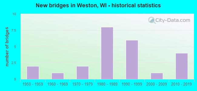
- New bridges - historical statistics
- 21950-1959
- 11960-1969
- 21970-1979
- 81980-1989
- 61990-1999
- 12000-2009
- 42010-2019


- Bridge Condition - Deck
- 5.9%Very good
- 52.9%Good
- 23.5%Satisfactory
- 11.8%Fair
- 5.9%Poor

- Bridge Condition - Superstructure
- 23.5%Very good
- 47.1%Good
- 23.5%Satisfactory
- 5.9%Poor

- Bridge Condition - Substructure
- 17.6%Very good
- 58.8%Good
- 17.6%Satisfactory
- 5.9%Fair

- Bridge Condition - Channel
- 92.3%Very good
- 7.7%Fair
Find on map >> Show street view
Structure Number: B370023, Location: 0.3M N JCT STH 29 (Lat: 44.901606, Lng: -89.505869), Route carried "on" structure: County highway , Year Built: 1955, Status: Open, Structure Length: 5.65m (18.54ft), Average Daily Traffic: 1,435 (year 2019), Average Future Daily Traffic: 1,578 (year 2040), Design Load: H 15, Features Intersected: EAU CLAIRE RIVER, Facility Carried by Structure: CTH J
Minimum Vertical Clearance: 30+ m (98+ ft), Kilometerpoint: 0.000, Lanes on structure: 2, Owner: County Highway Agency, Approaching Roadway Width: 8.5m (27.9ft), Material/Design: Steel continuous, Design/Construction: Stringer/Multi-beam, Number Of Spans In Main Unit: 3, Length of Maximum Span: 21.3m (69.9ft), Curb-To-Curb Width: 7.3m (24.0ft), Out-to-Out Width: 8.1m (26.6ft)
Condition: Deck: Fair, Superstructure: Satisfactory, Substructure: Fair, Channel: Very good, Operating Rating: 29.4 metric tons, Method Used To Determine Operating Rating: Load Factor (LF), Inventory Rating: 17.8 metric tons, Method Used To Determine Inventory Rating: Load Factor (LF), Structural Evaluation: Meets minimum limits, Deck Geometry: Meets minimum limits, Waterway Adequacy: Equal to present desirable criteria, Approach Roadway Alignment: Equal to present desirable criteria, Designated Inspection Frequency: Every 24 months, Inspection Date: September 2021, Deck Structure Type: Concrete Cast-file-Place, Wearing Surface/Protective System: Wearing Surface: Monolithic Concrete
Find on map >> Show street view
Structure Number: B370045, Location: 0.5M W JCT CTH SS (Lat: 44.945331, Lng: -89.521033), Route carried "on" structure: County highway , Year Built: 1959, Status: Open, Structure Length: 2.38m (7.81ft), Average Daily Traffic: 3,895 (year 2019), Average Future Daily Traffic: 4,284 (year 2040), Design Load: H 15, Features Intersected: BIG SANDY CREEK, Facility Carried by Structure: CTH N
Minimum Vertical Clearance: 30+ m (98+ ft), Kilometerpoint: 0.000, Lanes on structure: 2, Owner: County Highway Agency, Approaching Roadway Width: 9.1m (29.9ft), Skew: 1 degrees, Material/Design: Concrete continuous, Design/Construction: Slab, Number Of Spans In Main Unit: 3, Length of Maximum Span: 9.1m (29.9ft), Curb-To-Curb Width: 7.9m (25.9ft), Out-to-Out Width: 8.5m (27.9ft)
Condition: Deck: Satisfactory, Superstructure: Satisfactory, Substructure: Satisfactory, Channel: Very good, Operating Rating: 31.0 metric tons, Method Used To Determine Operating Rating: Load Factor (LF), Inventory Rating: 17.8 metric tons, Method Used To Determine Inventory Rating: Load Factor (LF), Structural Evaluation: Meets minimum limits, Deck Geometry: High priority of corrective action, Waterway Adequacy: Equal to present desirable criteria, Approach Roadway Alignment: Equal to present desirable criteria, Length Of Structure Improvement: 2.83m (9.28ft), Designated Inspection Frequency: Every 24 months, Inspection Date: September 2021, Bridge Improvement Cost: $352,000, Roadway Improvement Cost: $35,000, Total Project Cost: $528,000 ( Estimate for 2021), Deck Structure Type: Concrete Cast-file-Place, Wearing Surface/Protective System: Wearing Surface: Epoxy Overlay, Deck Protection: Epoxy Coated Reinforcing
Find on map >> Show street view
Structure Number: B370081, Location: 0.4M E JCT USH 51 BUS (Lat: 44.894225, Lng: -89.609131), Route carried "on" structure: City street , Year Built: 1989, Status: Open, Structure Length: 8.11m (26.61ft), Average Daily Traffic: 2,900 (year 2019), Average Future Daily Traffic: 2,900 (year 2039), Design Load: HS 20, Features Intersected: STH 29, Facility Carried by Structure: LRD VOLKMAN STREET
Minimum Vertical Clearance: 30+ m (98+ ft), Kilometerpoint: 0.000, Lanes on structure: 2, Lanes under structure: 4, Owner: State Highway Agency, Approaching Roadway Width: 15.8m (51.8ft), Skew: 1 degrees, Material/Design: Steel continuous, Design/Construction: Stringer/Multi-beam, Number Of Spans In Main Unit: 2, Length of Maximum Span: 43.3m (142.1ft), Curb or Sidewalk Widths: Left: 2.0m (6.6ft), Right: 0.0m, Curb-To-Curb Width: 15.8m (51.8ft), Out-to-Out Width: 18.1m (59.4ft)
Condition: Deck: Satisfactory, Superstructure: Satisfactory, Substructure: Good, Operating Rating: 60.4 metric tons, Method Used To Determine Operating Rating: Load Factor (LF), Inventory Rating: 35.6 metric tons, Method Used To Determine Inventory Rating: Load Factor (LF), Structural Evaluation: Equal to present minimum criteria, Deck Geometry: Superior to present desirable criteria, Underclear: Somewhat better than minimum adequacy, Approach Roadway Alignment: Equal to present desirable criteria, Designated Inspection Frequency: Every 24 months, Inspection Date: October 2020, Deck Structure Type: Concrete Cast-file-Place, Wearing Surface/Protective System: Wearing Surface: Monolithic Concrete, Deck Protection: Epoxy Coated Reinforcing
Find on map >> Show street view
Structure Number: B370133, Location: 0.1M E JCT CTH J (Lat: 44.974461, Lng: -89.491514), Route carried "on" structure: City street , Year Built: 1990, Status: Open, Structure Length: 2.56m (8.40ft), Average Daily Traffic: 130 (year 2019), Truck Traffic: 11%, Average Future Daily Traffic: 143 (year 2039), Design Load: HS 20, Features Intersected: BIG SANDY CREEK, Facility Carried by Structure: LRD OWL RIDGE RD
Minimum Vertical Clearance: 30+ m (98+ ft), Kilometerpoint: 0.000, Lanes on structure: 2, Owner: Town or Township Highway Agency, Approaching Roadway Width: 8.5m (27.9ft), Skew: 1 degrees, Material/Design: Concrete continuous, Design/Construction: Slab, Number Of Spans In Main Unit: 2, Length of Maximum Span: 12.5m (41.0ft), Curb-To-Curb Width: 7.3m (24.0ft), Out-to-Out Width: 7.9m (25.9ft)
Condition: Deck: Good, Superstructure: Good, Substructure: Good, Channel: Very good, Operating Rating: 63.7 metric tons, Method Used To Determine Operating Rating: Load Factor (LF), Inventory Rating: 37.3 metric tons, Method Used To Determine Inventory Rating: Load Factor (LF), Structural Evaluation: Better than present minimum criteria, Deck Geometry: Somewhat better than minimum adequacy, Waterway Adequacy: Equal to present desirable criteria, Approach Roadway Alignment: Equal to present desirable criteria, Designated Inspection Frequency: Every 48 months, Inspection Date: September 2020, Deck Structure Type: Concrete Cast-file-Place, Wearing Surface/Protective System: Wearing Surface: Monolithic Concrete, Deck Protection: Epoxy Coated Reinforcing
Find on map >> Show street view
Structure Number: B370152, Location: 1.3M N JCT CTH N (Lat: 44.963025, Lng: -89.508325), Route carried "on" structure: City street , Year Built: 1983, Status: Open, Structure Length: 1.88m (6.17ft), Average Daily Traffic: 572 (year 2019), Truck Traffic: 10%, Average Future Daily Traffic: 629 (year 2039), Design Load: H 20, Features Intersected: PRAHL CREEK, Facility Carried by Structure: LRD COLONIAL RD
Minimum Vertical Clearance: 30+ m (98+ ft), Kilometerpoint: 0.000, Lanes on structure: 2, Owner: Town or Township Highway Agency, Approaching Roadway Width: 7.9m (25.9ft), Material/Design: Prestressed concrete, Design/Construction: Stringer/Multi-beam, Number Of Spans In Main Unit: 1, Length of Maximum Span: 18.3m (60.0ft), Curb-To-Curb Width: 7.3m (24.0ft), Out-to-Out Width: 7.9m (25.9ft)
Condition: Deck: Good, Superstructure: Very good, Substructure: Good, Channel: Very good, Operating Rating: 45.7 metric tons, Method Used To Determine Operating Rating: Load Factor (LF), Inventory Rating: 25.9 metric tons, Method Used To Determine Inventory Rating: Load Factor (LF), Structural Evaluation: Equal to present minimum criteria, Deck Geometry: Meets minimum limits, Waterway Adequacy: Equal to present desirable criteria, Approach Roadway Alignment: Equal to present desirable criteria, Designated Inspection Frequency: Every 24 months, Inspection Date: September 2020, Deck Structure Type: Concrete Cast-file-Place, Wearing Surface/Protective System: Wearing Surface: Monolithic Concrete, Deck Protection: Epoxy Coated Reinforcing
Find on map >> Show street view
Structure Number: B370174, Location: 3.9M S JCT CTH N (Lat: 44.918236, Lng: -89.552069), Route carried "on" structure: City street , Year Built: 1979, Status: Open, Structure Length: 5.20m (17.06ft), Average Daily Traffic: 391 (year 2019), Average Future Daily Traffic: 430 (year 2039), Design Load: HS 20, Features Intersected: EAU CLAIRE RIVER, Facility Carried by Structure: LRD ROSS AVENUE
Minimum Vertical Clearance: 30+ m (98+ ft), Kilometerpoint: 0.000, Lanes on structure: 2, Owner: City or Municipal Highway Agency, Approaching Roadway Width: 10.4m (34.1ft), Material/Design: Prestressed concrete continuous, Design/Construction: Stringer/Multi-beam, Number Of Spans In Main Unit: 2, Length of Maximum Span: 25.9m (85.0ft), Curb-To-Curb Width: 10.4m (34.1ft), Out-to-Out Width: 11.0m (36.1ft)
Condition: Deck: Fair, Superstructure: Satisfactory, Substructure: Satisfactory, Channel: Very good, Operating Rating: 73.0 metric tons, Method Used To Determine Operating Rating: Load Factor (LF), Inventory Rating: 34.0 metric tons, Method Used To Determine Inventory Rating: Load Factor (LF), Structural Evaluation: Equal to present minimum criteria, Deck Geometry: Better than present minimum criteria, Waterway Adequacy: Equal to present desirable criteria, Approach Roadway Alignment: Equal to present desirable criteria, Designated Inspection Frequency: Every 24 months, Inspection Date: October 2020, Deck Structure Type: Concrete Cast-file-Place, Wearing Surface/Protective System: Wearing Surface: Bituminous
Find on map >> Show street view
Structure Number: B370175, Location: 1.3M N JCT CTH N (Lat: 44.964539, Lng: -89.491789), Route carried "on" structure: County highway , Year Built: 1979, Status: Open, Structure Length: 3.10m (10.17ft), Average Daily Traffic: 1,435 (year 2019), Average Future Daily Traffic: 1,578 (year 2040), Design Load: HS 20, Features Intersected: BIG SANDY CREEK, Facility Carried by Structure: CTH J
Minimum Vertical Clearance: 30+ m (98+ ft), Kilometerpoint: 0.000, Lanes on structure: 2, Owner: County Highway Agency, Approaching Roadway Width: 8.5m (27.9ft), Skew: 3 degrees, Material/Design: Concrete, Design/Construction: Slab, Number Of Spans In Main Unit: 3, Length of Maximum Span: 11.7m (38.4ft), Curb-To-Curb Width: 10.4m (34.1ft), Out-to-Out Width: 11.0m (36.1ft)
Condition: Deck: Poor, Superstructure: Poor, Substructure: Good, Channel: Very good, Operating Rating: 75.1 metric tons, Method Used To Determine Operating Rating: Load Factor (LF), Inventory Rating: 43.7 metric tons, Method Used To Determine Inventory Rating: Load Factor (LF), Structural Evaluation: Meets minimum limits, Deck Geometry: Equal to present minimum criteria, Waterway Adequacy: Equal to present desirable criteria, Approach Roadway Alignment: Equal to present desirable criteria, Length Of Structure Improvement: 3.54m (11.61ft), Designated Inspection Frequency: Every 12 months, Inspection Date: September 2021, Bridge Improvement Cost: $377,000, Roadway Improvement Cost: $37,000, Total Project Cost: $566,000 ( Estimate for 2021), Deck Structure Type: Concrete Cast-file-Place, Wearing Surface/Protective System: Wearing Surface: Monolithic Concrete
Find on map >> Show street view
Structure Number: B370177, Location: 4.5M N JCT CTH XX TO W (Lat: 44.894239, Lng: -89.572350), Route carried "on" structure: County highway , Year Built: 1989, Status: Open, Structure Length: 7.12m (23.36ft), Average Daily Traffic: 12,300 (year 2019), Average Future Daily Traffic: 12,300 (year 2039), Design Load: HS 20, Features Intersected: STH 29, Facility Carried by Structure: CTH X
Minimum Vertical Clearance: 30+ m (98+ ft), Kilometerpoint: 0.000, Lanes on structure: 5, Lanes under structure: 4, Owner: State Highway Agency, Approaching Roadway Width: 8.2m (26.9ft), Skew: 20 degrees, Material/Design: Prestressed concrete continuous, Design/Construction: Stringer/Multi-beam, Number Of Spans In Main Unit: 2, Length of Maximum Span: 35.1m (115.2ft), Curb-To-Curb Width: 8.2m (26.9ft), Out-to-Out Width: 22.3m (73.2ft)
Condition: Deck: Satisfactory, Superstructure: Good, Substructure: Satisfactory, Operating Rating: 65.0 metric tons, Method Used To Determine Operating Rating: Load Factor (LF), Inventory Rating: 34.0 metric tons, Method Used To Determine Inventory Rating: Load Factor (LF), Structural Evaluation: Equal to present minimum criteria, Deck Geometry: High priority of replacement, Underclear: Somewhat better than minimum adequacy, Approach Roadway Alignment: Equal to present desirable criteria, Length Of Structure Improvement: 7.56m (24.80ft), Designated Inspection Frequency: Every 24 months, Inspection Date: October 2020, Bridge Improvement Cost: $1,073,000, Roadway Improvement Cost: $107,000, Total Project Cost: $1,610,000 ( Estimate for 2021), Deck Structure Type: Concrete Cast-file-Place, Wearing Surface/Protective System: Wearing Surface: Monolithic Concrete, Deck Protection: Epoxy Coated Reinforcing
Find on map >> Show street view
Structure Number: B370178, Location: 1.8M E JCT CTH X (Lat: 44.894317, Lng: -89.536742), Route carried "on" structure: City street , Year Built: 1989, Status: Open, Structure Length: 7.24m (23.75ft), Average Daily Traffic: 1,900 (year 2019), Average Future Daily Traffic: 1,900 (year 2039), Design Load: HS 20, Features Intersected: STH 29, Facility Carried by Structure: LRD RYAN ST
Minimum Vertical Clearance: 30+ m (98+ ft), Kilometerpoint: 0.000, Lanes on structure: 2, Lanes under structure: 4, Owner: State Highway Agency, Approaching Roadway Width: 10.4m (34.1ft), Skew: 1 degrees, Material/Design: Prestressed concrete continuous, Design/Construction: Stringer/Multi-beam, Number Of Spans In Main Unit: 2, Length of Maximum Span: 37.8m (124.0ft), Curb-To-Curb Width: 10.4m (34.1ft), Out-to-Out Width: 11.3m (37.1ft)
Condition: Deck: Good, Superstructure: Good, Substructure: Good, Operating Rating: 60.4 metric tons, Method Used To Determine Operating Rating: Load Factor (LF), Inventory Rating: 38.9 metric tons, Method Used To Determine Inventory Rating: Load Factor (LF), Structural Evaluation: Better than present minimum criteria, Deck Geometry: Equal to present minimum criteria, Underclear: Better than present minimum criteria, Approach Roadway Alignment: Equal to present desirable criteria, Designated Inspection Frequency: Every 24 months, Inspection Date: October 2020, Deck Structure Type: Concrete Cast-file-Place, Wearing Surface/Protective System: Wearing Surface: Monolithic Concrete, Deck Protection: Epoxy Coated Reinforcing
Find on map >> Show street view
Structure Number: B370179, Location: 4.1M E JCT CTH X (Lat: 44.891067, Lng: -89.499961), Route carried "on" structure: State highway 29, Year Built: 1990, Status: Open, Structure Length: 4.76m (15.62ft), Average Daily Traffic: 7,000 (year 2018), Truck Traffic: 8%, Average Future Daily Traffic: 9,350 (year 2038), Design Load: HS 20, Features Intersected: CTH J
Minimum Vertical Clearance: 30+ m (98+ ft), Kilometerpoint: 0.000, Lanes on structure: 2, Lanes under structure: 2, Base Highway Network: Yes, Owner: State Highway Agency, Approaching Roadway Width: 12.2m (40.0ft), Skew: 2 degrees, Material/Design: Steel, Design/Construction: Stringer/Multi-beam, Number Of Spans In Main Unit: 1, Length of Maximum Span: 45.7m (149.9ft), Curb-To-Curb Width: 12.2m (40.0ft), Out-to-Out Width: 13.1m (43.0ft)
Condition: Deck: Good, Superstructure: Very good, Substructure: Good, Operating Rating: 76.7 metric tons, Method Used To Determine Operating Rating: Load Factor (LF), Inventory Rating: 45.4 metric tons, Method Used To Determine Inventory Rating: Load Factor (LF), Structural Evaluation: Better than present minimum criteria, Deck Geometry: Better than present minimum criteria, Underclear: Equal to present minimum criteria, Approach Roadway Alignment: Equal to present desirable criteria, Designated Inspection Frequency: Every 24 months, Inspection Date: October 2020, Deck Structure Type: Concrete Cast-file-Place, Wearing Surface/Protective System: Wearing Surface: Epoxy Overlay, Deck Protection: Epoxy Coated Reinforcing
Find on map >> Show street view
Structure Number: B370204, Location: 0.9M N JCT CTH N (Lat: 44.958589, Lng: -89.508069), Route carried "on" structure: City street , Year Built: 1983, Status: Open, Structure Length: 2.31m (7.58ft), Average Daily Traffic: 93 (year 2019), Average Future Daily Traffic: 102 (year 2039), Design Load: H 20, Features Intersected: BIG SANDY CREEK, Facility Carried by Structure: LRD 93RD ST
Minimum Vertical Clearance: 30+ m (98+ ft), Kilometerpoint: 0.000, Lanes on structure: 2, Owner: Town or Township Highway Agency, Approaching Roadway Width: 7.9m (25.9ft), Material/Design: Prestressed concrete, Design/Construction: Stringer/Multi-beam, Number Of Spans In Main Unit: 1, Length of Maximum Span: 22.6m (74.1ft), Curb-To-Curb Width: 7.3m (24.0ft), Out-to-Out Width: 7.9m (25.9ft)
Condition: Deck: Satisfactory, Superstructure: Good, Substructure: Good, Channel: Very good, Operating Rating: 44.1 metric tons, Method Used To Determine Operating Rating: Load Factor (LF), Inventory Rating: 29.2 metric tons, Method Used To Determine Inventory Rating: Load Factor (LF), Structural Evaluation: Better than present minimum criteria, Deck Geometry: Equal to present minimum criteria, Waterway Adequacy: Equal to present desirable criteria, Approach Roadway Alignment: Equal to present desirable criteria, Designated Inspection Frequency: Every 24 months, Inspection Date: September 2020, Deck Structure Type: Concrete Cast-file-Place, Wearing Surface/Protective System: Wearing Surface: Monolithic Concrete, Deck Protection: Epoxy Coated Reinforcing
Find on map >> Show street view
Structure Number: B370249, Location: 1.3M W JCT CTH J (Lat: 44.974372, Lng: -89.516994), Route carried "on" structure: City street , Year Built: 1991, Status: Open, Structure Length: 2.80m (9.19ft), Average Daily Traffic: 40 (year 2019), Average Future Daily Traffic: 44 (year 2039), Design Load: HS 20, Features Intersected: PRAHL CREEK, Facility Carried by Structure: LRD OWL RIDGE RD
Minimum Vertical Clearance: 30+ m (98+ ft), Kilometerpoint: 0.000, Lanes on structure: 2, Owner: Town or Township Highway Agency, Approaching Roadway Width: 7.3m (24.0ft), Skew: 1 degrees, Material/Design: Concrete continuous, Design/Construction: Slab, Number Of Spans In Main Unit: 2, Length of Maximum Span: 13.7m (44.9ft), Curb-To-Curb Width: 7.3m (24.0ft), Out-to-Out Width: 7.9m (25.9ft)
Condition: Deck: Good, Superstructure: Good, Substructure: Very good, Channel: Very good, Operating Rating: 65.0 metric tons, Method Used To Determine Operating Rating: Load Factor (LF), Inventory Rating: 38.9 metric tons, Method Used To Determine Inventory Rating: Load Factor (LF), Structural Evaluation: Better than present minimum criteria, Deck Geometry: Equal to present minimum criteria, Waterway Adequacy: Equal to present desirable criteria, Approach Roadway Alignment: Equal to present desirable criteria, Designated Inspection Frequency: Every 48 months, Inspection Date: September 2020, Deck Structure Type: Concrete Cast-file-Place, Wearing Surface/Protective System: Wearing Surface: Monolithic Concrete, Deck Protection: Epoxy Coated Reinforcing
Find on map >> Show street view
Structure Number: B370295, Location: 1.3M S JCT CTH N (Lat: 44.927944, Lng: -89.572278), Route carried "on" structure: City street , Year Built: 2011, Status: Open, Structure Length: 6.46m (21.19ft), Average Daily Traffic: 9,635 (year 2019), Truck Traffic: 4%, Average Future Daily Traffic: 10,598 (year 2035), Design Load: HL 93, Features Intersected: EAU CLAIRE RIVER, Facility Carried by Structure: LRD CTH X/CAMP PHI
Minimum Vertical Clearance: 30+ m (98+ ft), Kilometerpoint: 0.000, Lanes on structure: 5, Owner: County Highway Agency, Approaching Roadway Width: 20.1m (65.9ft), Material/Design: Prestressed concrete continuous, Design/Construction: Stringer/Multi-beam, Number Of Spans In Main Unit: 2, Length of Maximum Span: 31.7m (104.0ft), Curb or Sidewalk Widths: Left: 3.7m (12.1ft), Right: 0.0m, Curb-To-Curb Width: 20.1m (65.9ft), Out-to-Out Width: 26.7m (87.6ft)
Condition: Deck: Good, Superstructure: Good, Substructure: Good, Channel: Very good, Operating Rating: 50.9 metric tons, Method Used To Determine Operating Rating: Load and Resistance Factor Rating (LRFR) rating reported by rating factor(RF) method using HL-93 loadings, Inventory Rating: 39.2 metric tons, Method Used To Determine Inventory Rating: Load and Resistance Factor Rating (LRFR) rating reported by rating factor(RF) method using HL-93 loadings, Structural Evaluation: Better than present minimum criteria, Deck Geometry: Somewhat better than minimum adequacy, Waterway Adequacy: Equal to present desirable criteria, Approach Roadway Alignment: Equal to present desirable criteria, Designated Inspection Frequency: Every 48 months, Underwater Inspection Frequency: Every 60 months, Inspection Date: October 2019, Underwater Inspection Date: October 2017, Deck Structure Type: Concrete Cast-file-Place, Wearing Surface/Protective System: Wearing Surface: Monolithic Concrete
Find on map >> Show street view
Structure Number: B370309, Location: 0.2M S JCT CTH N (Lat: 44.943825, Lng: -89.491592), Route carried "on" structure: County highway , Year Built: 1998, Status: Open, Structure Length: 1.14m (3.74ft), Average Daily Traffic: 1,435 (year 2019), Average Future Daily Traffic: 1,578 (year 2035), Design Load: HS 20, Features Intersected: LITTLE SANDY CREEK, Facility Carried by Structure: CTH J
Minimum Vertical Clearance: 30+ m (98+ ft), Kilometerpoint: 0.000, Lanes on structure: 2, Owner: County Highway Agency, Approaching Roadway Width: 9.8m (32.2ft), Material/Design: Concrete, Design/Construction: Slab, Number Of Spans In Main Unit: 1, Length of Maximum Span: 10.7m (35.1ft), Curb-To-Curb Width: 9.1m (29.9ft), Out-to-Out Width: 9.3m (30.5ft)
Condition: Deck: Good, Superstructure: Good, Substructure: Good, Channel: Very good, Operating Rating: 57.0 metric tons, Method Used To Determine Operating Rating: Load Factor (LF), Inventory Rating: 34.0 metric tons, Method Used To Determine Inventory Rating: Load Factor (LF), Structural Evaluation: Better than present minimum criteria, Deck Geometry: Somewhat better than minimum adequacy, Waterway Adequacy: Equal to present desirable criteria, Approach Roadway Alignment: Equal to present desirable criteria, Designated Inspection Frequency: Every 48 months, Inspection Date: October 2019, Deck Structure Type: Concrete Cast-file-Place, Wearing Surface/Protective System: Wearing Surface: Monolithic Concrete
Find on map >> Show street view
Structure Number: B370331, Location: 0.4M S JCT CTH N (Lat: 44.939811, Lng: -89.512381), Route carried "on" structure: City street , Year Built: 2003, Status: Open, Structure Length: 1.42m (4.66ft), Average Daily Traffic: 974 (year 2019), Truck Traffic: 4%, Average Future Daily Traffic: 1,071 (year 2039), Design Load: HS 20, Features Intersected: LITTLE SANDY CREEK, Facility Carried by Structure: LRD LESTER STREET
Minimum Vertical Clearance: 30+ m (98+ ft), Kilometerpoint: 0.000, Lanes on structure: 2, Owner: Town or Township Highway Agency, Approaching Roadway Width: 10.4m (34.1ft), Material/Design: Concrete, Design/Construction: Slab, Number Of Spans In Main Unit: 1, Length of Maximum Span: 13.4m (44.0ft), Curb-To-Curb Width: 10.3m (33.8ft), Out-to-Out Width: 10.9m (35.8ft)
Condition: Deck: Good, Superstructure: Good, Substructure: Good, Channel: Very good, Operating Rating: 63.7 metric tons, Method Used To Determine Operating Rating: Load Factor (LF), Inventory Rating: 37.3 metric tons, Method Used To Determine Inventory Rating: Load Factor (LF), Structural Evaluation: Better than present minimum criteria, Deck Geometry: Equal to present minimum criteria, Waterway Adequacy: Equal to present desirable criteria, Approach Roadway Alignment: Equal to present desirable criteria, Designated Inspection Frequency: Every 48 months, Inspection Date: October 2020, Deck Structure Type: Concrete Cast-file-Place, Wearing Surface/Protective System: Wearing Surface: Monolithic Concrete, Deck Protection: Epoxy Coated Reinforcing
Find on map >> Show street view
Structure Number: B37042, Location: 2.7M W JCT CTH X (Lat: 44.811194, Lng: -89.672917), Route carried "on" structure: City street , Year Built: 2012, Status: Open, Structure Length: 8.27m (27.13ft), Average Daily Traffic: 6,200 (year 2019), Average Future Daily Traffic: 9,500 (year 2037), Design Load: HL 93, Features Intersected: IH 39, Facility Carried by Structure: LRD MAPLE RIDGE RD
Minimum Vertical Clearance: 30+ m (98+ ft), Kilometerpoint: 0.000, Lanes on structure: 3, Lanes under structure: 4, Owner: State Highway Agency, Approaching Roadway Width: 16.5m (54.1ft), Skew: 22 degrees, Material/Design: Prestressed concrete continuous, Design/Construction: Stringer/Multi-beam, Number Of Spans In Main Unit: 2, Length of Maximum Span: 41.8m (137.1ft), Curb or Sidewalk Widths: Left: 0.0m, Right: 3.7m (12.1ft), Curb-To-Curb Width: 16.5m (54.1ft), Out-to-Out Width: 23.2m (76.1ft)
Condition: Deck: Good, Superstructure: Very good, Substructure: Very good, Operating Rating: 43.4 metric tons, Method Used To Determine Operating Rating: Load and Resistance Factor Rating (LRFR) rating reported by rating factor(RF) method using HL-93 loadings, Inventory Rating: 33.4 metric tons, Method Used To Determine Inventory Rating: Load and Resistance Factor Rating (LRFR) rating reported by rating factor(RF) method using HL-93 loadings, Structural Evaluation: Equal to present desirable criteria, Deck Geometry: Better than present minimum criteria, Underclear: Better than present minimum criteria, Approach Roadway Alignment: Equal to present desirable criteria, Designated Inspection Frequency: Every 48 months, Inspection Date: June 2018, Deck Structure Type: Concrete Cast-file-Place, Wearing Surface/Protective System: Wearing Surface: Monolithic Concrete, Deck Protection: Epoxy Coated Reinforcing
Find on map >> Show street view
Structure Number: B370452, Location: 0.2M E JCT CTH J (Lat: 44.945581, Lng: -89.488097), Route carried "on" structure: County highway , Year Built: 2018, Status: Open, Structure Length: 1.52m (4.99ft), Average Daily Traffic: 1,640 (year 2019), Average Future Daily Traffic: 1,640 (year 2039), Design Load: HL 93, Features Intersected: LITTLE SANDY CREEK, Facility Carried by Structure: CTH N
Minimum Vertical Clearance: 30+ m (98+ ft), Kilometerpoint: 0.000, Lanes on structure: 2, Owner: County Highway Agency, Approaching Roadway Width: 9.8m (32.2ft), Material/Design: Concrete, Design/Construction: Slab, Number Of Spans In Main Unit: 1, Length of Maximum Span: 14.6m (47.9ft), Curb-To-Curb Width: 9.8m (32.2ft), Out-to-Out Width: 10.1m (33.1ft)
Condition: Deck: Very good, Superstructure: Very good, Substructure: Very good, Channel: Very good, Operating Rating: 49.2 metric tons, Method Used To Determine Operating Rating: Load and Resistance Factor Rating (LRFR) rating reported by rating factor(RF) method using HL-93 loadings, Inventory Rating: 37.9 metric tons, Method Used To Determine Inventory Rating: Load and Resistance Factor Rating (LRFR) rating reported by rating factor(RF) method using HL-93 loadings, Structural Evaluation: Equal to present desirable criteria, Deck Geometry: Somewhat better than minimum adequacy, Waterway Adequacy: Equal to present desirable criteria, Approach Roadway Alignment: Equal to present desirable criteria, Designated Inspection Frequency: Every 48 months, Inspection Date: September 2020
Find on map >> Show street view
Structure Number: P370953, Location: 2.4M S JCT STH 29 (Lat: 44.870044, Lng: -89.536578), Route carried "on" structure: City street , Year Built: 1965, Year Reconstructed: 2015, Status: Open, Structure Length: 0.65m (2.13ft), Average Daily Traffic: 50 (year 2019), Average Future Daily Traffic: 55 (year 2039), Design Load: H 15, Features Intersected: BULL JUNIOR CREEK, Facility Carried by Structure: LRD KMIECIK RD
Minimum Vertical Clearance: 30+ m (98+ ft), Kilometerpoint: 0.000, Lanes on structure: 2, Owner: City or Municipal Highway Agency, Approaching Roadway Width: 8.5m (27.9ft), Material/Design: Steel, Design/Construction: Culvert, Number Of Spans In Main Unit: 3, Length of Maximum Span: 2.7m (8.9ft)
Condition: Channel: Fair, Culverts: Good, Operating Rating: 53.9 metric tons, Method Used To Determine Operating Rating: Field evaluation and documented engineering judgment, Inventory Rating: 32.4 metric tons, Method Used To Determine Inventory Rating: Field evaluation and documented engineering judgment, Structural Evaluation: Better than present minimum criteria, Waterway Adequacy: Equal to present desirable criteria, Approach Roadway Alignment: Equal to present minimum criteria, Designated Inspection Frequency: Every 24 months, Inspection Date: October 2020, Deck Structure Type: Corrugated Steel, Wearing Surface/Protective System: Wearing Surface: Gravel
Find on map >> Show street view
Structure Number: B370081, Location: 0.5M E JCT USH 51 BUS (Lat: 44.894225, Lng: -89.609131), Route carried "under" structure: State highway 29, Year Built: 1989, Structure Length: 0. m, Average Daily Traffic: 28,100 (year 2019), Truck Traffic: 2%, Features Intersected: STH 29, Facility Carried by Structure: LRD VOLKMAN STREET
Minimum Vertical Clearance: 5.01m (16.44ft), Kilometerpoint: 0.000, Lanes on structure: 2, Lanes under structure: 4, Material/Design: Steel continuous, Design/Construction: Stringer/Multi-beam, Length of Maximum Span: 43.3m (142.1ft)
Find on map >> Show street view
Structure Number: B370177, Location: 2.5M E JCT USH 51 BUS (Lat: 44.894239, Lng: -89.572350), Route carried "under" structure: State highway 29, Year Built: 1989, Structure Length: 0. m, Average Daily Traffic: 12,200 (year 2019), Features Intersected: STH 29, Facility Carried by Structure: CTH X
Minimum Vertical Clearance: 5.00m (16.40ft), Kilometerpoint: 0.000, Lanes on structure: 5, Lanes under structure: 4, Material/Design: Prestressed concrete continuous, Design/Construction: Stringer/Multi-beam, Length of Maximum Span: 35.1m (115.2ft)
Find on map >> Show street view
Structure Number: B370178, Location: 4.0M E JCT USH 51 BUS (Lat: 44.894317, Lng: -89.536742), Route carried "under" structure: State highway 29, Year Built: 1989, Structure Length: 0. m, Average Daily Traffic: 15,800 (year 2019), Truck Traffic: 2%, Features Intersected: STH 29, Facility Carried by Structure: LRD RYAN ST
Minimum Vertical Clearance: 4.94m (16.21ft), Kilometerpoint: 0.000, Lanes on structure: 2, Lanes under structure: 4, Material/Design: Prestressed concrete continuous, Design/Construction: Stringer/Multi-beam, Length of Maximum Span: 37.8m (124.0ft)
Find on map >> Show street view
Structure Number: B370179, Location: 0.8M S JCT CTH JJ (Lat: 44.891067, Lng: -89.499961), Route carried "under" structure: County highway , Year Built: 1990, Structure Length: 0. m, Average Daily Traffic: 4,700 (year 2018), Features Intersected: CTH J, Facility Carried by Structure: STH 29 EB
Minimum Vertical Clearance: 4.97m (16.31ft), Kilometerpoint: 0.000, Lanes on structure: 2, Lanes under structure: 2, Material/Design: Steel, Design/Construction: Stringer/Multi-beam, Length of Maximum Span: 45.7m (149.9ft)
Find on map >> Show street view
Structure Number: B37018, Location: 0.8M S JCT CTH JJ (Lat: 44.891431, Lng: -89.499644), Route carried "under" structure: County highway , Year Built: 1990, Structure Length: 0. m, Average Daily Traffic: 4,750 (year 2018), Features Intersected: CTH J, Facility Carried by Structure: STH 29 WB
Minimum Vertical Clearance: 5.04m (16.54ft), Kilometerpoint: 0.000, Lanes on structure: 2, Lanes under structure: 2, Material/Design: Steel, Design/Construction: Stringer/Multi-beam, Length of Maximum Span: 45.7m (149.9ft)
Find on map >> Show street view
Structure Number: B370422, Location: BETWEEN CTH X - ALDEERSON (Lat: 44.894194, Lng: -89.582639), Route carried "under" structure: State highway , Year Built: 2011, Structure Length: 0. m, Average Daily Traffic: 25,800 (year 2019), Truck Traffic: 7%, Features Intersected: STH 29 EB, Facility Carried by Structure: PEDESTRIAN BRIDGE
Minimum Vertical Clearance: 5.35m (17.55ft), Kilometerpoint: 0.000, Lanes under structure: 4, Material/Design: Prestressed concrete, Design/Construction: Stringer/Multi-beam, Length of Maximum Span: 27.4m (89.9ft)