Bridge Statistics for Westport, Oklahoma (OK)
Condition, Traffic, Stress, Structural Evaluation, Project Costs
- National Bridge Inventory (NBI) Statistics
- 33Number of bridges
- 449ft / 137mTotal length
- $43,320,000Total costs
- 200,242Total average daily traffic
- 45,532Total average daily truck traffic
- National Bridge Inventory (NBI) Registered Bridges for Westport
- No street view available for this location
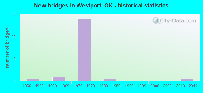
- New bridges - historical statistics
- 11950-1959
- 21960-1969
- 281970-1979
- 11980-1989
- 12010-2019


- Bridge Condition - Deck
- 6.3%Excellent
- 6.3%Very good
- 18.8%Good
- 37.5%Satisfactory
- 31.3%Fair

- Bridge Condition - Superstructure
- 6.3%Excellent
- 12.5%Very good
- 37.5%Good
- 18.8%Satisfactory
- 25.0%Fair

- Bridge Condition - Substructure
- 6.3%Very good
- 43.8%Good
- 6.3%Satisfactory
- 43.8%Fair

- Bridge Condition - Channel
- 42.9%Very good
- 42.9%Good
- 14.3%Fair

- Bridge Condition - Culverts
- 25.0%Very good
- 50.0%Satisfactory
- 25.0%Critical
Find on map >> Show street view
Structure Number: 13916, Location: 2.5E 1.4S OF TERLTON (Lat: 36.170661, Lng: -96.447258), Route carried "on" structure: County highway N3680, Year Built: 1957, Status: Posted for load, Structure Length: 9.24m (30.31ft), Average Daily Traffic: 292 (year 2020), Truck Traffic: 10%, Average Future Daily Traffic: 467 (year 2040), Design Load: HS 20, Features Intersected: HOUSE CREEK
Minimum Vertical Clearance: 30+ m (98+ ft), Kilometerpoint: 0.483, Lanes on structure: 1, Owner: County Highway Agency, Approaching Roadway Width: 4.9m (16.1ft), Material/Design: Steel continuous, Design/Construction: Stringer/Multi-beam, Number Of Spans In Main Unit: 3, Length of Maximum Span: 35.1m (115.2ft), Curb-To-Curb Width: 5.0m (16.4ft), Out-to-Out Width: 5.9m (19.4ft)
Condition: Deck: Satisfactory, Superstructure: Satisfactory, Substructure: Fair, Channel: Good, Operating Rating: 17.6 metric tons, Method Used To Determine Operating Rating: Load Factor (LF), Inventory Rating: 10.5 metric tons, Method Used To Determine Inventory Rating: Load Factor (LF), Structural Evaluation: High priority of replacement, Deck Geometry: High priority of replacement, Waterway Adequacy: Superior to present desirable criteria, Approach Roadway Alignment: Equal to present desirable criteria, Bridge Posting: Required (Relationship of Operating Rating to Maximum Legal Load: > 39.9% below), Length Of Structure Improvement: 11.21m (36.78ft), Designated Inspection Frequency: Every 24 months, Inspection Date: August 2021, Bridge Improvement Cost: $573,000, Roadway Improvement Cost: $315,000, Total Project Cost: $896,000 ( Estimate for 2015), Deck Structure Type: Concrete Cast-file-Place, Wearing Surface/Protective System: Wearing Surface: Monolithic Concrete
Find on map >> Show street view
Structure Number: 15577, Location: 7.6 MI S JCT SH 99 (Lat: 36.228672, Lng: -96.391336), Route carried "on" structure: US 64, Year Built: 1962, Status: Open, Structure Length: 11.73m (38.48ft), Average Daily Traffic: 5,800 (year 2020), Truck Traffic: 16%, Average Future Daily Traffic: 9,280 (year 2040), Design Load: H 20, Features Intersected: BEAR CREEK
Minimum Vertical Clearance: 30+ m (98+ ft), Kilometerpoint: 21.255, Lanes on structure: 2, Base Highway Network: Yes, Owner: State Highway Agency, Approaching Roadway Width: 11.6m (38.1ft), Material/Design: Steel, Design/Construction: Stringer/Multi-beam, Number Of Spans In Main Unit: 5, Length of Maximum Span: 23.5m (77.1ft), Curb-To-Curb Width: 11.6m (38.1ft), Out-to-Out Width: 12.2m (40.0ft)
Condition: Deck: Very good, Superstructure: Very good, Substructure: Good, Channel: Very good, Operating Rating: 47.5 metric tons, Method Used To Determine Operating Rating: Load Factor (LF), Inventory Rating: 28.5 metric tons, Method Used To Determine Inventory Rating: Load Factor (LF), Structural Evaluation: Better than present minimum criteria, Deck Geometry: Somewhat better than minimum adequacy, Waterway Adequacy: Equal to present desirable criteria, Approach Roadway Alignment: Better than present minimum criteria, Length Of Structure Improvement: 12.75m (41.83ft), Designated Inspection Frequency: Every 24 months, Inspection Date: August 2021, Bridge Improvement Cost: $1,713,000, Roadway Improvement Cost: $2,826,000, Total Project Cost: $4,795,000 ( Estimate for 2015), Deck Structure Type: Concrete Cast-file-Place, Wearing Surface/Protective System: Wearing Surface: Bituminous
Find on map >> Show street view
Structure Number: 15868, Location: OSAGE-PAWNEE C/L (Lat: 36.183714, Lng: -96.268389), Route carried "on" structure: US 64, Year Built: 1963, Year Reconstructed: 1995, Status: Open, Structure Length: 30.36m (99.61ft), Average Daily Traffic: 16,000 (year 2020), Truck Traffic: 25%, Average Future Daily Traffic: 25,600 (year 2040), Design Load: H 20, Features Intersected: ARKANSAS RIVER
Minimum Vertical Clearance: 30+ m (98+ ft), Kilometerpoint: 56.527, Lanes on structure: 4, Base Highway Network: Yes, Owner: State Highway Agency, Approaching Roadway Width: 11.0m (36.1ft), Navigation Control: Yes ( Vertical Clearance: 11.0m (36.1ft), Horizontal Clearance: 48.8m (160.1ft)), Material/Design: Steel, Design/Construction: Stringer/Multi-beam, Number Of Spans In Main Unit: 6, Length of Maximum Span: 50.6m (166.0ft), Curb-To-Curb Width: 18.9m (62.0ft), Out-to-Out Width: 19.8m (65.0ft)
Condition: Deck: Fair, Superstructure: Satisfactory, Substructure: Fair, Channel: Very good, Operating Rating: 67.7 metric tons, Method Used To Determine Operating Rating: Load Factor (LF), Inventory Rating: 40.6 metric tons, Method Used To Determine Inventory Rating: Load Factor (LF), Structural Evaluation: Somewhat better than minimum adequacy, Deck Geometry: Equal to present minimum criteria, Waterway Adequacy: Equal to present desirable criteria, Approach Roadway Alignment: Equal to present desirable criteria, Length Of Structure Improvement: 31.06m (101.90ft), Designated Inspection Frequency: Every 24 months, Underwater Inspection Frequency: Every 60 months, Inspection Date: August 2021, Underwater Inspection Date: October 2017, Bridge Improvement Cost: $10,359,000, Roadway Improvement Cost: $4,500,000, Total Project Cost: $15,700,000 ( Estimate for 2015), Deck Structure Type: Concrete Cast-file-Place, Wearing Surface/Protective System: Wearing Surface: Monolithic Concrete
Find on map >> Show street view
Structure Number: 17674, Location: .25S 1W OF SH48/CIM TPK (Lat: 36.215797, Lng: -96.406542), Route carried "on" structure: County highway D0550, Year Built: 1970, Status: Open, Structure Length: 0.64m (2.10ft), Average Daily Traffic: 250 (year 2020), Truck Traffic: 10%, Average Future Daily Traffic: 400 (year 2040), Design Load: HS 20, Features Intersected: COWSKIN CREEK
Minimum Vertical Clearance: 30+ m (98+ ft), Kilometerpoint: 0.483, Lanes on structure: 2, Owner: County Highway Agency, Approaching Roadway Width: 6.7m (22.0ft), Material/Design: Concrete, Design/Construction: Culvert, Number Of Spans In Main Unit: 2, Length of Maximum Span: 3.0m (9.8ft)
Condition: Channel: Fair, Culverts: Critical, Operating Rating: 32.7 metric tons, Method Used To Determine Operating Rating: Load Factor (LF), Inventory Rating: 19.6 metric tons, Method Used To Determine Inventory Rating: Load Factor (LF), Structural Evaluation: High priority of replacement, Waterway Adequacy: Somewhat better than minimum adequacy, Approach Roadway Alignment: Equal to present minimum criteria, Length Of Structure Improvement: 2.72m (8.92ft), Designated Inspection Frequency: Every 6 months, Inspection Date: August 2021, Bridge Improvement Cost: $100,000, Roadway Improvement Cost: $75,000, Total Project Cost: $225,000 ( Estimate for 2015), Deck Structure Type: Concrete Cast-file-Place, Wearing Surface/Protective System: Wearing Surface: Gravel
Find on map >> Show street view
Structure Number: 18519, Location: 3 MI'S W JCT SH 48 (Lat: 36.219781, Lng: -96.446108), Route carried "on" structure: County highway N3680, Year Built: 1973, Status: Open, Structure Length: 4.75m (15.58ft), Average Daily Traffic: 5,700 (year 2020), Truck Traffic: 15%, Average Future Daily Traffic: 9,120 (year 2040), Design Load: HS 20, Features Intersected: CIMARRON TP UNDER
Minimum Vertical Clearance: 30+ m (98+ ft), Kilometerpoint: 33.742, Lanes on structure: 2, Lanes under structure: 4, Owner: State Toll Authority, Approaching Roadway Width: 9.4m (30.8ft), Material/Design: Prestressed concrete, Design/Construction: Stringer/Multi-beam, Number Of Spans In Main Unit: 2, Length of Maximum Span: 24.1m (79.1ft), Curb-To-Curb Width: 8.5m (27.9ft), Out-to-Out Width: 9.4m (30.8ft)
Condition: Deck: Good, Superstructure: Very good, Substructure: Good, Operating Rating: 57.6 metric tons, Method Used To Determine Operating Rating: Load Factor (LF), Inventory Rating: 34.5 metric tons, Method Used To Determine Inventory Rating: Load Factor (LF), Structural Evaluation: Better than present minimum criteria, Deck Geometry: High priority of replacement, Underclear: Equal to present minimum criteria, Approach Roadway Alignment: Better than present minimum criteria, Length Of Structure Improvement: 4.75m (15.58ft), Designated Inspection Frequency: Every 24 months, Inspection Date: April 2020, Bridge Improvement Cost: $593,000, Roadway Improvement Cost: $890,000, Total Project Cost: $1,699,000 ( Estimate for 2015), Deck Structure Type: Concrete Cast-file-Place, Wearing Surface/Protective System: Wearing Surface: Monolithic Concrete
Find on map >> Show street view
Structure Number: 18557, Location: .5 MI W. JCT SH 48 (Lat: 36.218267, Lng: -96.400394), Route carried "on" structure: US 412, Year Built: 1973, Status: Open, Structure Length: 5.82m (19.09ft), Average Daily Traffic: 8,600 (year 2020), Truck Traffic: 25%, Average Future Daily Traffic: 13,760 (year 2040), Design Load: HS 20, Features Intersected: COWSKIN CREEK, Facility Carried by Structure: CIMARRON TP
Minimum Vertical Clearance: 30+ m (98+ ft), Kilometerpoint: 37.876, Lanes on structure: 4, Base Highway Network: Yes, Toll: On toll road, Owner: State Toll Authority, Approaching Roadway Width: 26.5m (86.9ft), Skew: 20 degrees, Material/Design: Prestressed concrete, Design/Construction: Stringer/Multi-beam, Number Of Spans In Main Unit: 3, Length of Maximum Span: 19.2m (63.0ft), Curb-To-Curb Width: 25.3m (83.0ft), Out-to-Out Width: 26.2m (86.0ft)
Condition: Deck: Fair, Superstructure: Good, Substructure: Good, Channel: Good, Operating Rating: 58.9 metric tons, Method Used To Determine Operating Rating: Load Factor (LF), Inventory Rating: 35.2 metric tons, Method Used To Determine Inventory Rating: Allowable Stress (AS), Structural Evaluation: Better than present minimum criteria, Deck Geometry: Superior to present desirable criteria, Waterway Adequacy: Equal to present desirable criteria, Approach Roadway Alignment: Equal to present desirable criteria, Length Of Structure Improvement: 8.78m (28.81ft), Designated Inspection Frequency: Every 24 months, Inspection Date: April 2020, Bridge Improvement Cost: $1,097,000, Roadway Improvement Cost: $1,646,000, Total Project Cost: $3,129,000 ( Estimate for 2015), Deck Structure Type: Concrete Cast-file-Place, Wearing Surface/Protective System: Wearing Surface: Bituminous
Find on map >> Show street view
Structure Number: 18747, Location: 3.8 MI N CREEK CO (Lat: 36.217411, Lng: -96.392553), Route carried "on" structure: Other road 412, Year Built: 1974, Status: Open, Structure Length: 5.24m (17.19ft), Average Daily Traffic: 8,600 (year 2020), Truck Traffic: 25%, Average Future Daily Traffic: 13,760 (year 2040), Design Load: HS 20, Features Intersected: S.H. 48 UNDER, Facility Carried by Structure: CIMARRON TP
Minimum Vertical Clearance: 30+ m (98+ ft), Kilometerpoint: 38.294, Lanes on structure: 4, Lanes under structure: 3, Base Highway Network: Yes, Toll: On toll road, Owner: State Toll Authority, Approaching Roadway Width: 26.5m (86.9ft), Skew: 23 degrees, Material/Design: Prestressed concrete, Design/Construction: Stringer/Multi-beam, Number Of Spans In Main Unit: 3, Length of Maximum Span: 30.5m (100.1ft), Curb-To-Curb Width: 26.2m (86.0ft), Out-to-Out Width: 27.1m (88.9ft)
Condition: Deck: Fair, Superstructure: Good, Substructure: Good, Operating Rating: 54.9 metric tons, Method Used To Determine Operating Rating: Load Factor (LF), Inventory Rating: 32.8 metric tons, Method Used To Determine Inventory Rating: Allowable Stress (AS), Structural Evaluation: Better than present minimum criteria, Deck Geometry: Superior to present desirable criteria, Underclear: Equal to present minimum criteria, Approach Roadway Alignment: Equal to present desirable criteria, Length Of Structure Improvement: 5.24m (17.19ft), Designated Inspection Frequency: Every 24 months, Inspection Date: April 2020, Bridge Improvement Cost: $654,000, Roadway Improvement Cost: $981,000, Total Project Cost: $1,873,000 ( Estimate for 2015), Deck Structure Type: Concrete Cast-file-Place, Wearing Surface/Protective System: Wearing Surface: Monolithic Concrete
Find on map >> Show street view
Structure Number: 19033, Location: 18.5 MI E SH 99 (Lat: 36.216339, Lng: -96.305078), Route carried "on" structure: US 64, Year Built: 1975, Status: Open, Structure Length: 3.14m (10.30ft), Average Daily Traffic: 7,100 (year 2020), Truck Traffic: 25%, Average Future Daily Traffic: 11,360 (year 2040), Design Load: HS 20, Features Intersected: CO. RD. UNDER
Minimum Vertical Clearance: 30+ m (98+ ft), Kilometerpoint: 30.056, Lanes on structure: 2, Lanes under structure: 2, Base Highway Network: Yes (Inventory Route: 5900006H, Subroute: 38), Owner: State Highway Agency, Approaching Roadway Width: 12.2m (40.0ft), Skew: 10 degrees, Material/Design: Concrete continuous, Design/Construction: Slab, Number Of Spans In Main Unit: 3, Length of Maximum Span: 12.2m (40.0ft), Curb-To-Curb Width: 12.4m (40.7ft), Out-to-Out Width: 13.3m (43.6ft)
Condition: Deck: Satisfactory, Superstructure: Good, Substructure: Good, Operating Rating: 66.0 metric tons, Method Used To Determine Operating Rating: Load Factor (LF), Inventory Rating: 39.5 metric tons, Method Used To Determine Inventory Rating: Load Factor (LF), Structural Evaluation: Better than present minimum criteria, Deck Geometry: Better than present minimum criteria, Underclear: Meets minimum limits, Approach Roadway Alignment: Equal to present desirable criteria, Length Of Structure Improvement: 5.61m (18.41ft), Designated Inspection Frequency: Every 24 months, Inspection Date: June 2021, Bridge Improvement Cost: $487,000, Roadway Improvement Cost: $803,000, Total Project Cost: $1,363,000 ( Estimate for 2015), Deck Structure Type: Concrete Cast-file-Place, Wearing Surface/Protective System: Wearing Surface: Monolithic Concrete
Find on map >> Show street view
Structure Number: 19034, Location: 18.5 MI E SH 99 (Lat: 36.216033, Lng: -96.305081), Route carried "on" structure: US 64, Year Built: 1975, Status: Open, Structure Length: 3.14m (10.30ft), Average Daily Traffic: 7,000 (year 2020), Truck Traffic: 25%, Average Future Daily Traffic: 11,200 (year 2040), Design Load: HS 20, Features Intersected: CO. RD. UNDER
Minimum Vertical Clearance: 30+ m (98+ ft), Kilometerpoint: 30.056, Lanes on structure: 2, Lanes under structure: 2, Base Highway Network: Yes, Owner: State Highway Agency, Approaching Roadway Width: 12.2m (40.0ft), Skew: 10 degrees, Material/Design: Concrete continuous, Design/Construction: Slab, Number Of Spans In Main Unit: 3, Length of Maximum Span: 12.2m (40.0ft), Curb-To-Curb Width: 12.4m (40.7ft), Out-to-Out Width: 13.3m (43.6ft)
Condition: Deck: Satisfactory, Superstructure: Good, Substructure: Good, Operating Rating: 59.8 metric tons, Method Used To Determine Operating Rating: Load Factor (LF), Inventory Rating: 35.8 metric tons, Method Used To Determine Inventory Rating: Load Factor (LF), Structural Evaluation: Better than present minimum criteria, Deck Geometry: Better than present minimum criteria, Underclear: Meets minimum limits, Approach Roadway Alignment: Equal to present desirable criteria, Length Of Structure Improvement: 5.61m (18.41ft), Designated Inspection Frequency: Every 24 months, Inspection Date: June 2021, Bridge Improvement Cost: $487,000, Roadway Improvement Cost: $803,000, Total Project Cost: $1,363,000 ( Estimate for 2015), Deck Structure Type: Concrete Cast-file-Place, Wearing Surface/Protective System: Wearing Surface: Monolithic Concrete
Find on map >> Show street view
Structure Number: 19038, Location: 14.0 MI E SH 99 (Lat: 36.217086, Lng: -96.386475), Route carried "on" structure: Other road 412, Year Built: 1975, Status: Open, Structure Length: 3.41m (11.19ft), Average Daily Traffic: 4,500 (year 2020), Truck Traffic: 25%, Average Future Daily Traffic: 7,200 (year 2040), Design Load: HS 20, Features Intersected: U.S. 64 UNDER, Facility Carried by Structure: CIMARRON TP
Minimum Vertical Clearance: 30+ m (98+ ft), Kilometerpoint: 38.616, Lanes on structure: 2, Lanes under structure: 2, Base Highway Network: Yes, Toll: On toll road, Owner: State Toll Authority, Approaching Roadway Width: 11.0m (36.1ft), Skew: 13 degrees, Material/Design: Steel, Design/Construction: Stringer/Multi-beam, Number Of Spans In Main Unit: 1, Length of Maximum Span: 33.2m (108.9ft), Curb-To-Curb Width: 11.3m (37.1ft), Out-to-Out Width: 12.2m (40.0ft)
Condition: Deck: Good, Superstructure: Good, Substructure: Satisfactory, Operating Rating: 44.5 metric tons, Method Used To Determine Operating Rating: Allowable Stress (AS), Inventory Rating: 32.7 metric tons, Method Used To Determine Inventory Rating: Allowable Stress (AS), Structural Evaluation: Equal to present minimum criteria, Deck Geometry: Equal to present minimum criteria, Underclear: Meets minimum limits, Approach Roadway Alignment: Equal to present desirable criteria, Length Of Structure Improvement: 3.41m (11.19ft), Designated Inspection Frequency: Every 24 months, Inspection Date: April 2020, Bridge Improvement Cost: $262,000, Roadway Improvement Cost: $393,000, Total Project Cost: $761,000 ( Estimate for 2015), Deck Structure Type: Concrete Cast-file-Place, Wearing Surface/Protective System: Wearing Surface: Monolithic Concrete
Find on map >> Show street view
Structure Number: 19039, Location: 14.0 MI E SH 99 (Lat: 36.216814, Lng: -96.386292), Route carried "on" structure: Other road 412, Year Built: 1975, Status: Open, Structure Length: 3.41m (11.19ft), Average Daily Traffic: 4,300 (year 2020), Truck Traffic: 25%, Average Future Daily Traffic: 6,880 (year 2040), Design Load: HS 20, Features Intersected: U.S. 64 UNDER, Facility Carried by Structure: CIMARRON TP
Minimum Vertical Clearance: 30+ m (98+ ft), Kilometerpoint: 38.616, Lanes on structure: 2, Lanes under structure: 2, Base Highway Network: Yes, Toll: On toll road, Owner: State Toll Authority, Approaching Roadway Width: 11.0m (36.1ft), Skew: 13 degrees, Material/Design: Steel, Design/Construction: Stringer/Multi-beam, Number Of Spans In Main Unit: 1, Length of Maximum Span: 33.2m (108.9ft), Curb-To-Curb Width: 11.3m (37.1ft), Out-to-Out Width: 12.2m (40.0ft)
Condition: Deck: Good, Superstructure: Good, Substructure: Good, Operating Rating: 44.5 metric tons, Method Used To Determine Operating Rating: Allowable Stress (AS), Inventory Rating: 32.7 metric tons, Method Used To Determine Inventory Rating: Allowable Stress (AS), Structural Evaluation: Better than present minimum criteria, Deck Geometry: Equal to present minimum criteria, Underclear: Meets minimum limits, Approach Roadway Alignment: Equal to present desirable criteria, Length Of Structure Improvement: 3.41m (11.19ft), Designated Inspection Frequency: Every 24 months, Inspection Date: April 2020, Bridge Improvement Cost: $262,000, Roadway Improvement Cost: $393,000, Total Project Cost: $761,000 ( Estimate for 2015), Deck Structure Type: Concrete Cast-file-Place, Wearing Surface/Protective System: Wearing Surface: Monolithic Concrete
Find on map >> Show street view
Structure Number: 19065, Location: 21.3 MI E SH 99 (Lat: 36.186808, Lng: -96.271206), Route carried "on" structure: County highway , Year Built: 1975, Status: Open, Structure Length: 5.24m (17.19ft), Average Daily Traffic: 100 (year 2020), Truck Traffic: 15%, Average Future Daily Traffic: 160 (year 2040), Design Load: HS 20, Features Intersected: U.S. 64 UNDER, Facility Carried by Structure: BEAR GLEN RD.
Minimum Vertical Clearance: 30+ m (98+ ft), Kilometerpoint: 34.689, Lanes on structure: 2, Lanes under structure: 4, Owner: State Highway Agency, Approaching Roadway Width: 12.8m (42.0ft), Material/Design: Prestressed concrete, Design/Construction: Stringer/Multi-beam, Number Of Spans In Main Unit: 2, Length of Maximum Span: 25.9m (85.0ft), Curb-To-Curb Width: 13.0m (42.7ft), Out-to-Out Width: 13.9m (45.6ft)
Condition: Deck: Fair, Superstructure: Satisfactory, Substructure: Fair, Operating Rating: 52.3 metric tons, Method Used To Determine Operating Rating: Load Factor (LF), Inventory Rating: 31.3 metric tons, Method Used To Determine Inventory Rating: Load Factor (LF), Structural Evaluation: Somewhat better than minimum adequacy, Deck Geometry: Superior to present desirable criteria, Underclear: Equal to present minimum criteria, Approach Roadway Alignment: Equal to present desirable criteria, Length Of Structure Improvement: 8.40m (27.56ft), Designated Inspection Frequency: Every 24 months, Inspection Date: June 2021, Bridge Improvement Cost: $689,000, Roadway Improvement Cost: $1,137,000, Total Project Cost: $1,929,000 ( Estimate for 2015), Deck Structure Type: Concrete Cast-file-Place, Wearing Surface/Protective System: Wearing Surface: Monolithic Concrete
Find on map >> Show street view
Structure Number: 1907, Location: 16.0 MI E SH 99 (Lat: 36.216283, Lng: -96.349461), Route carried "on" structure: County highway , Year Built: 1975, Status: Open, Structure Length: 5.85m (19.19ft), Average Daily Traffic: 100 (year 2020), Truck Traffic: 15%, Average Future Daily Traffic: 160 (year 2040), Design Load: HS 20, Features Intersected: U.S. 64 UNDER, Facility Carried by Structure: WESTPORT RD.
Minimum Vertical Clearance: 30+ m (98+ ft), Kilometerpoint: 26.050, Lanes on structure: 2, Lanes under structure: 4, Owner: State Highway Agency, Approaching Roadway Width: 12.8m (42.0ft), Skew: 1 degrees, Material/Design: Prestressed concrete, Design/Construction: Stringer/Multi-beam, Number Of Spans In Main Unit: 2, Length of Maximum Span: 29.0m (95.1ft), Curb-To-Curb Width: 12.8m (42.0ft), Out-to-Out Width: 13.3m (43.6ft)
Condition: Deck: Satisfactory, Superstructure: Fair, Substructure: Fair, Operating Rating: 69.8 metric tons, Method Used To Determine Operating Rating: Load Factor (LF), Inventory Rating: 31.2 metric tons, Method Used To Determine Inventory Rating: Load Factor (LF), Structural Evaluation: Somewhat better than minimum adequacy, Deck Geometry: Superior to present desirable criteria, Underclear: Equal to present minimum criteria, Approach Roadway Alignment: Equal to present desirable criteria, Length Of Structure Improvement: 8.66m (28.41ft), Designated Inspection Frequency: Every 24 months, Inspection Date: June 2021, Bridge Improvement Cost: $707,000, Roadway Improvement Cost: $1,166,000, Total Project Cost: $1,979,000 ( Estimate for 2015), Deck Structure Type: Concrete Cast-file-Place, Wearing Surface/Protective System: Wearing Surface: Monolithic Concrete
Find on map >> Show street view
Structure Number: 19071, Location: 16.5 MI E SH 99 (Lat: 36.216208, Lng: -96.340667), Route carried "on" structure: County highway , Year Built: 1975, Status: Open, Structure Length: 5.85m (19.19ft), Average Daily Traffic: 100 (year 2020), Truck Traffic: 15%, Average Future Daily Traffic: 160 (year 2040), Design Load: HS 20, Features Intersected: U.S. 64 UNDER, Facility Carried by Structure: COWSKIN BAY RD.
Minimum Vertical Clearance: 30+ m (98+ ft), Kilometerpoint: 26.837, Lanes on structure: 2, Lanes under structure: 4, Owner: State Highway Agency, Approaching Roadway Width: 9.8m (32.2ft), Material/Design: Prestressed concrete, Design/Construction: Stringer/Multi-beam, Number Of Spans In Main Unit: 2, Length of Maximum Span: 29.0m (95.1ft), Curb-To-Curb Width: 9.8m (32.2ft), Out-to-Out Width: 10.7m (35.1ft)
Condition: Deck: Satisfactory, Superstructure: Fair, Substructure: Fair, Operating Rating: 75.6 metric tons, Method Used To Determine Operating Rating: Load Factor (LF), Inventory Rating: 35.0 metric tons, Method Used To Determine Inventory Rating: Load Factor (LF), Structural Evaluation: Somewhat better than minimum adequacy, Deck Geometry: Equal to present desirable criteria, Underclear: Equal to present minimum criteria, Approach Roadway Alignment: Equal to present desirable criteria, Length Of Structure Improvement: 8.40m (27.56ft), Designated Inspection Frequency: Every 24 months, Inspection Date: June 2021, Bridge Improvement Cost: $689,000, Roadway Improvement Cost: $1,137,000, Total Project Cost: $1,929,000 ( Estimate for 2015), Deck Structure Type: Concrete Cast-file-Place, Wearing Surface/Protective System: Wearing Surface: Monolithic Concrete
Find on map >> Show street view
Structure Number: 19072, Location: 17.5 MI E SH 99 (Lat: 36.216072, Lng: -96.322822), Route carried "on" structure: County highway , Year Built: 1975, Status: Open, Structure Length: 5.85m (19.19ft), Average Daily Traffic: 100 (year 2020), Truck Traffic: 15%, Average Future Daily Traffic: 160 (year 2040), Design Load: HS 20, Features Intersected: U.S. 64 UNDER, Facility Carried by Structure: 296TH W.AVE.
Minimum Vertical Clearance: 30+ m (98+ ft), Kilometerpoint: 28.463, Lanes on structure: 2, Lanes under structure: 4, Owner: State Highway Agency, Approaching Roadway Width: 9.8m (32.2ft), Material/Design: Prestressed concrete, Design/Construction: Stringer/Multi-beam, Number Of Spans In Main Unit: 2, Length of Maximum Span: 29.0m (95.1ft), Curb-To-Curb Width: 9.8m (32.2ft), Out-to-Out Width: 10.7m (35.1ft)
Condition: Deck: Satisfactory, Superstructure: Fair, Substructure: Fair, Operating Rating: 75.6 metric tons, Method Used To Determine Operating Rating: Load Factor (LF), Inventory Rating: 35.0 metric tons, Method Used To Determine Inventory Rating: Load Factor (LF), Structural Evaluation: Somewhat better than minimum adequacy, Deck Geometry: Equal to present desirable criteria, Underclear: Equal to present minimum criteria, Approach Roadway Alignment: Equal to present desirable criteria, Length Of Structure Improvement: 8.40m (27.56ft), Designated Inspection Frequency: Every 24 months, Inspection Date: June 2021, Bridge Improvement Cost: $689,000, Roadway Improvement Cost: $1,137,000, Total Project Cost: $1,929,000 ( Estimate for 2015), Deck Structure Type: Concrete Cast-file-Place, Wearing Surface/Protective System: Wearing Surface: Monolithic Concrete
Find on map >> Show street view
Structure Number: 19083, Location: 19.5 MI E SH 99 (Lat: 36.209167, Lng: -96.290097), Route carried "on" structure: County highway , Year Built: 1975, Status: Open, Structure Length: 6.58m (21.59ft), Average Daily Traffic: 100 (year 2020), Truck Traffic: 15%, Average Future Daily Traffic: 160 (year 2040), Design Load: HS 20, Features Intersected: U.S. 64 UNDER, Facility Carried by Structure: KEYSTONE RD.
Minimum Vertical Clearance: 30+ m (98+ ft), Kilometerpoint: 31.682, Lanes on structure: 2, Lanes under structure: 4, Owner: State Highway Agency, Approaching Roadway Width: 12.8m (42.0ft), Skew: 3 degrees, Material/Design: Steel continuous, Design/Construction: Girder and Floorbeam System, Number Of Spans In Main Unit: 2, Length of Maximum Span: 32.3m (106.0ft), Curb-To-Curb Width: 13.0m (42.7ft), Out-to-Out Width: 13.9m (45.6ft)
Condition: Deck: Fair, Superstructure: Fair, Substructure: Fair, Operating Rating: 61.4 metric tons, Method Used To Determine Operating Rating: Load Factor (LF), Inventory Rating: 36.8 metric tons, Method Used To Determine Inventory Rating: Load Factor (LF), Structural Evaluation: Somewhat better than minimum adequacy, Deck Geometry: Superior to present desirable criteria, Underclear: Equal to present minimum criteria, Approach Roadway Alignment: Equal to present desirable criteria, Length Of Structure Improvement: 10.38m (34.06ft), Designated Inspection Frequency: Every 24 months, Inspection Date: June 2021, Bridge Improvement Cost: $827,000, Roadway Improvement Cost: $1,364,000, Total Project Cost: $2,314,000 ( Estimate for 2015), Deck Structure Type: Concrete Cast-file-Place, Wearing Surface/Protective System: Wearing Surface: Monolithic Concrete
Find on map >> Show street view
Structure Number: 20369, Location: .6E 1N .8E OF TERLTON (Lat: 36.202717, Lng: -96.466725), Route carried "on" structure: County highway E0560, Year Built: 1983, Status: Open, Structure Length: 0.64m (2.10ft), Average Daily Traffic: 100 (year 2020), Truck Traffic: 10%, Average Future Daily Traffic: 160 (year 2040), Design Load: HS 20, Features Intersected: CREEK
Minimum Vertical Clearance: 30+ m (98+ ft), Kilometerpoint: 1.287, Lanes on structure: 2, Owner: County Highway Agency, Approaching Roadway Width: 5.2m (17.1ft), Material/Design: Concrete, Design/Construction: Culvert, Number Of Spans In Main Unit: 2, Length of Maximum Span: 3.0m (9.8ft), Curb-To-Curb Width: 8.8m (28.9ft), Out-to-Out Width: 9.3m (30.5ft)
Condition: Channel: Good, Culverts: Satisfactory, Operating Rating: 45.4 metric tons, Method Used To Determine Operating Rating: Load Factor (LF), Inventory Rating: 27.2 metric tons, Method Used To Determine Inventory Rating: Load Factor (LF), Structural Evaluation: Equal to present minimum criteria, Deck Geometry: Better than present minimum criteria, Waterway Adequacy: Meets minimum limits, Approach Roadway Alignment: Somewhat better than minimum adequacy, Length Of Structure Improvement: 2.72m (8.92ft), Designated Inspection Frequency: Every 24 months, Inspection Date: August 2021, Bridge Improvement Cost: $100,000, Roadway Improvement Cost: $75,000, Total Project Cost: $225,000 ( Estimate for 2015), Deck Structure Type: Concrete Cast-file-Place, Wearing Surface/Protective System: Wearing Surface: Bituminous
Find on map >> Show street view
Structure Number: 27174, Location: 54.64 (Lat: 36.218514, Lng: -96.410572), Route carried "on" structure: Other road N3670, Year Built: 1973, Status: Open, Structure Length: 0.67m (2.20ft), Average Daily Traffic: 8,600 (year 2020), Truck Traffic: 25%, Average Future Daily Traffic: 13,760 (year 2040), Design Load: HS 20, Features Intersected: CO. RD. N3670 UNDER, Facility Carried by Structure: CIMARRON TP
Minimum Vertical Clearance: 30+ m (98+ ft), Kilometerpoint: 36.894, Lanes on structure: 4, Lanes under structure: 2, Base Highway Network: Yes, Toll: On toll road, Owner: State Toll Authority, Approaching Roadway Width: 26.5m (86.9ft), Material/Design: Concrete, Design/Construction: Culvert, Number Of Spans In Main Unit: 1, Length of Maximum Span: 6.1m (20.0ft), Curb-To-Curb Width: 32.3m (106.0ft), Out-to-Out Width: 32.9m (107.9ft)
Condition: Culverts: Very good, Operating Rating: 44.5 metric tons, Method Used To Determine Operating Rating: Allowable Stress (AS), Inventory Rating: 32.7 metric tons, Method Used To Determine Inventory Rating: Allowable Stress (AS), Structural Evaluation: Equal to present desirable criteria, Deck Geometry: Superior to present desirable criteria, Approach Roadway Alignment: Equal to present minimum criteria, Length Of Structure Improvement: 3.05m (10.01ft), Designated Inspection Frequency: Every 24 months, Inspection Date: April 2020, Bridge Improvement Cost: $100,000, Roadway Improvement Cost: $75,000, Total Project Cost: $225,000 ( Estimate for 2015)
Find on map >> Show street view
Structure Number: 27175, Location: 57.51 (Lat: 36.219800, Lng: -96.462831), Route carried "on" structure: Other road , Year Built: 1973, Status: Open, Structure Length: 0.67m (2.20ft), Average Daily Traffic: 8,600 (year 2020), Truck Traffic: 25%, Average Future Daily Traffic: 13,760 (year 2040), Design Load: HS 20, Features Intersected: CO. RD. UNDER, Facility Carried by Structure: CIMARRON TP
Minimum Vertical Clearance: 30+ m (98+ ft), Kilometerpoint: 32.243, Lanes on structure: 4, Lanes under structure: 2, Base Highway Network: Yes, Toll: On toll road, Owner: State Toll Authority, Approaching Roadway Width: 26.5m (86.9ft), Skew: 20 degrees, Material/Design: Concrete, Design/Construction: Culvert, Number Of Spans In Main Unit: 1, Length of Maximum Span: 6.1m (20.0ft), Curb-To-Curb Width: 32.9m (107.9ft), Out-to-Out Width: 33.5m (109.9ft)
Condition: Culverts: Satisfactory, Operating Rating: 44.5 metric tons, Method Used To Determine Operating Rating: Allowable Stress (AS), Inventory Rating: 32.7 metric tons, Method Used To Determine Inventory Rating: Allowable Stress (AS), Structural Evaluation: Equal to present minimum criteria, Deck Geometry: Superior to present desirable criteria, Underclear: High priority of replacement, Approach Roadway Alignment: Equal to present desirable criteria, Length Of Structure Improvement: 3.05m (10.01ft), Designated Inspection Frequency: Every 24 months, Inspection Date: April 2020, Bridge Improvement Cost: $100,000, Roadway Improvement Cost: $75,000, Total Project Cost: $225,000 ( Estimate for 2015)
Find on map >> Show street view
Structure Number: 31951, Location: .3 S PAWNEE C/L (Lat: 36.159167, Lng: -96.400556), Route carried "on" structure: State highway 48, Year Built: 2019, Status: Open, Structure Length: 24.43m (80.15ft), Average Daily Traffic: 2,500 (year 2020), Truck Traffic: 7%, Average Future Daily Traffic: 3,700 (year 2040), Design Load: HL 93, Features Intersected: CIMMARON RIVER
Minimum Vertical Clearance: 30+ m (98+ ft), Kilometerpoint: 51.193, Lanes on structure: 2, Owner: State Highway Agency, Approaching Roadway Width: 14.0m (45.9ft), Material/Design: Prestressed concrete, Design/Construction: Stringer/Multi-beam, Number Of Spans In Main Unit: 7, Length of Maximum Span: 36.8m (120.7ft), Curb-To-Curb Width: 13.4m (44.0ft), Out-to-Out Width: 14.1m (46.3ft)
Condition: Deck: Excellent, Superstructure: Excellent, Substructure: Very good, Channel: Very good, Operating Rating: 66.2 metric tons, Method Used To Determine Operating Rating: Load and Resistance Factor (LRFR), Inventory Rating: 32.7 metric tons, Method Used To Determine Inventory Rating: Load and Resistance Factor (LRFR), Structural Evaluation: Equal to present desirable criteria, Deck Geometry: Better than present minimum criteria, Waterway Adequacy: Equal to present desirable criteria, Approach Roadway Alignment: Equal to present desirable criteria, Designated Inspection Frequency: Every 24 months, Inspection Date: July 2021, Deck Structure Type: Concrete Cast-file-Place, Wearing Surface/Protective System: Wearing Surface: Monolithic Concrete, Membrane: Epoxy, Deck Protection: Epoxy Coated Reinforcing
Find on map >> Show street view
Structure Number: 18519, Location: 3 MI'S W JCT SH 48 (Lat: 36.219781, Lng: -96.446108), Route carried "under" structure: Other road 412, Year Built: 1973, Structure Length: 0. m, Average Daily Traffic: 8,600 (year 2020), Truck Traffic: 25%, Features Intersected: CIMARRON TP UNDER, Facility Carried by Structure: CO. RD. N3680
Minimum Vertical Clearance: 5.31m (17.42ft), Kilometerpoint: 33.742, Lanes on structure: 2, Lanes under structure: 4, Toll: On toll road, Material/Design: Prestressed concrete, Design/Construction: Stringer/Multi-beam, Length of Maximum Span: 24.1m (79.1ft)
Find on map >> Show street view
Structure Number: 18747, Location: 3.8 MI N CREEK CO (Lat: 36.217411, Lng: -96.392553), Route carried "under" structure: State highway 48, Year Built: 1974, Structure Length: 0. m, Average Daily Traffic: 2,800 (year 2020), Truck Traffic: 15%, Features Intersected: S.H. 48 UNDER, Facility Carried by Structure: CIMARRON TP
Minimum Vertical Clearance: 5.64m (18.50ft), Kilometerpoint: 6.210, Lanes on structure: 4, Lanes under structure: 3, Material/Design: Prestressed concrete, Design/Construction: Stringer/Multi-beam, Length of Maximum Span: 30.5m (100.1ft)
Find on map >> Show street view
Structure Number: 19033, Location: 18.5 MI E SH 99 (Lat: 36.216339, Lng: -96.305078), Route carried "under" structure: County highway , Year Built: 1975, Structure Length: 0. m, Average Daily Traffic: 100 (year 2020), Truck Traffic: 15%, Features Intersected: CO. RD. UNDER, Facility Carried by Structure: U.S. 64
Minimum Vertical Clearance: 4.83m (15.85ft), Kilometerpoint: 30.056, Lanes on structure: 2, Lanes under structure: 2, Material/Design: Concrete continuous, Design/Construction: Slab, Length of Maximum Span: 12.2m (40.0ft)
Find on map >> Show street view
Structure Number: 19034, Location: 18.5 MI E SH 99 (Lat: 36.216033, Lng: -96.305081), Route carried "under" structure: County highway , Year Built: 1975, Structure Length: 0. m, Average Daily Traffic: 100 (year 2020), Truck Traffic: 15%, Features Intersected: CO. RD. UNDER, Facility Carried by Structure: U.S. 64
Minimum Vertical Clearance: 4.80m (15.75ft), Kilometerpoint: 30.056, Lanes on structure: 2, Lanes under structure: 2, Material/Design: Concrete continuous, Design/Construction: Slab, Length of Maximum Span: 12.2m (40.0ft)
Find on map >> Show street view
Structure Number: 19038, Location: 14.0 MI E SH 99 (Lat: 36.217086, Lng: -96.386475), Route carried "under" structure: US 64, Year Built: 1975, Structure Length: 0. m, Average Daily Traffic: 14,000 (year 2020), Truck Traffic: 16%, Features Intersected: U.S. 64 UNDER, Facility Carried by Structure: CIMARRON TP
Minimum Vertical Clearance: 5.69m (18.67ft), Kilometerpoint: 22.623, Lanes on structure: 2, Lanes under structure: 1, Material/Design: Steel, Design/Construction: Stringer/Multi-beam, Length of Maximum Span: 33.2m (108.9ft)
Find on map >> Show street view
Structure Number: 19039, Location: 14.0 MI E SH 99 (Lat: 36.216814, Lng: -96.386292), Route carried "under" structure: US 64, Year Built: 1975, Structure Length: 0. m, Average Daily Traffic: 14,000 (year 2020), Truck Traffic: 16%, Features Intersected: U.S. 64 UNDER, Facility Carried by Structure: CIMARRON TP
Minimum Vertical Clearance: 5.16m (16.93ft), Kilometerpoint: 22.655, Lanes on structure: 2, Lanes under structure: 1, Material/Design: Steel, Design/Construction: Stringer/Multi-beam, Length of Maximum Span: 33.2m (108.9ft)
Find on map >> Show street view
Structure Number: 19065, Location: 21.3 MI E SH 99 (Lat: 36.186808, Lng: -96.271206), Route carried "under" structure: US 64, Year Built: 1975, Structure Length: 0. m, Average Daily Traffic: 16,000 (year 2020), Truck Traffic: 25%, Features Intersected: U.S. 64 UNDER, Facility Carried by Structure: BEAR GLEN RD.
Minimum Vertical Clearance: 4.98m (16.34ft), Kilometerpoint: 55.828, Lanes on structure: 2, Lanes under structure: 4, Material/Design: Prestressed concrete, Design/Construction: Stringer/Multi-beam, Length of Maximum Span: 25.9m (85.0ft)
Find on map >> Show street view
Structure Number: 1907, Location: 16.0 MI E SH 99 (Lat: 36.216283, Lng: -96.349461), Route carried "under" structure: US 64, Year Built: 1975, Structure Length: 0. m, Average Daily Traffic: 14,000 (year 2020), Truck Traffic: 25%, Features Intersected: U.S. 64 UNDER, Facility Carried by Structure: WESTPORT RD.
Minimum Vertical Clearance: 5.05m (16.57ft), Kilometerpoint: 26.050, Lanes on structure: 2, Lanes under structure: 4, Material/Design: Prestressed concrete, Design/Construction: Stringer/Multi-beam, Length of Maximum Span: 29.0m (95.1ft)
Find on map >> Show street view
Structure Number: 19071, Location: 16.5 MI E SH 99 (Lat: 36.216208, Lng: -96.340667), Route carried "under" structure: US 64, Year Built: 1975, Structure Length: 0. m, Average Daily Traffic: 14,000 (year 2020), Truck Traffic: 25%, Features Intersected: U.S. 64 UNDER, Facility Carried by Structure: COWSKIN BAY RD.
Minimum Vertical Clearance: 5.08m (16.67ft), Kilometerpoint: 43.192, Lanes on structure: 2, Lanes under structure: 4, Material/Design: Prestressed concrete, Design/Construction: Stringer/Multi-beam, Length of Maximum Span: 29.0m (95.1ft)
Find on map >> Show street view
Structure Number: 19072, Location: 17.5 MI E SH 99 (Lat: 36.216072, Lng: -96.322822), Route carried "under" structure: US 64, Year Built: 1975, Structure Length: 0. m, Average Daily Traffic: 14,000 (year 2020), Truck Traffic: 25%, Features Intersected: U.S. 64 UNDER, Facility Carried by Structure: 296TH W.AVE.
Minimum Vertical Clearance: 5.03m (16.50ft), Kilometerpoint: 28.463, Lanes on structure: 2, Lanes under structure: 4, Material/Design: Prestressed concrete, Design/Construction: Stringer/Multi-beam, Length of Maximum Span: 29.0m (95.1ft)
Find on map >> Show street view
Structure Number: 19083, Location: 19.5 MI E SH 99 (Lat: 36.209167, Lng: -96.290097), Route carried "under" structure: US 64, Year Built: 1975, Structure Length: 0. m, Average Daily Traffic: 14,000 (year 2020), Truck Traffic: 25%, Features Intersected: U.S. 64 UNDER, Facility Carried by Structure: KEYSTONE RD.
Minimum Vertical Clearance: 4.93m (16.17ft), Kilometerpoint: 50.986, Lanes on structure: 2, Lanes under structure: 4, Material/Design: Steel continuous, Design/Construction: Girder and Floorbeam System, Length of Maximum Span: 32.3m (106.0ft)
Find on map >> Show street view
Structure Number: 27174, Location: 54.64 (Lat: 36.218514, Lng: -96.410572), Route carried "under" structure: County highway , Year Built: 1973, Structure Length: 0. m, Average Daily Traffic: 100 (year 2020), Truck Traffic: 15%, Features Intersected: CO. RD. N3670 UNDER, Facility Carried by Structure: CIMARRON TP
Minimum Vertical Clearance: 4.85m (15.91ft), Kilometerpoint: 36.894, Lanes on structure: 4, Lanes under structure: 2, Material/Design: Concrete, Design/Construction: Culvert, Length of Maximum Span: 6.1m (20.0ft)
Find on map >> Show street view
Structure Number: 27175, Location: 57.51 (Lat: 36.219800, Lng: -96.462831), Route carried "under" structure: County highway , Year Built: 1973, Structure Length: 0. m, Average Daily Traffic: 100 (year 2020), Truck Traffic: 15%, Features Intersected: CO. RD. UNDER, Facility Carried by Structure: CIMARRON TP
Minimum Vertical Clearance: 4.82m (15.81ft), Kilometerpoint: 32.243, Lanes on structure: 4, Lanes under structure: 2, Material/Design: Concrete, Design/Construction: Culvert, Length of Maximum Span: 6.1m (20.0ft)