Bridge Statistics for Westville, Indiana (IN)
Condition, Traffic, Stress, Structural Evaluation, Project Costs
- National Bridge Inventory (NBI) Statistics
- 23Number of bridges
- 190ft / 57.8mTotal length
- $1,207,000Total costs
- 226,105Total average daily traffic
- 49,084Total average daily truck traffic
- National Bridge Inventory (NBI) Registered Bridges for Westville
- No street view available for this location
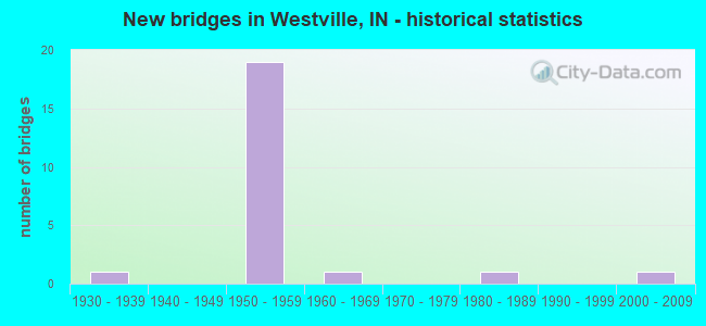
- New bridges - historical statistics
- 11930-1939
- 191950-1959
- 11960-1969
- 11980-1989
- 12000-2009

- Reconstructed bridges - Historical Statistics
- 11960-1969
- 01970-1979
- 31980-1989
- 51990-1999
- 02000-2009
- 12010-2019


- Bridge Condition - Deck
- 10.0%Very good
- 40.0%Good
- 40.0%Satisfactory
- 10.0%Fair

- Bridge Condition - Superstructure
- 10.0%Very good
- 70.0%Good
- 10.0%Satisfactory
- 10.0%Fair

- Bridge Condition - Substructure
- 70.0%Good
- 20.0%Satisfactory
- 10.0%Fair

- Bridge Condition - Channel
- 50.0%Good
- 25.0%Fair
- 25.0%Poor

- Bridge Condition - Culverts
- 50.0%Good
- 50.0%Satisfactory
Find on map >> Show street view
Structure Number: 65, Location: 01.19 W US 6 (Lat: 41.531619, Lng: -86.930139), Route carried "on" structure: State highway 2, Year Built: 1958, Year Reconstructed: 2015, Status: Open, Structure Length: 2.83m (9.28ft), Average Daily Traffic: 5,362 (year 2004), Truck Traffic: 10%, Average Future Daily Traffic: 7,428 (year 2030), Design Load: HS 20, Features Intersected: FORBES DITCH
Minimum Vertical Clearance: 30+ m (98+ ft), Kilometerpoint: 0.048, Lanes on structure: 2, Owner: State Highway Agency, Approaching Roadway Width: 13.4m (44.0ft), Skew: 4 degrees, Material/Design: Steel continuous, Design/Construction: Stringer/Multi-beam, Number Of Spans In Main Unit: 3, Length of Maximum Span: 10.8m (35.4ft), Curb-To-Curb Width: 13.4m (44.0ft), Out-to-Out Width: 14.3m (46.9ft)
Condition: Deck: Satisfactory, Superstructure: Good, Substructure: Good, Channel: Good, Operating Rating: 37.6 metric tons, Method Used To Determine Operating Rating: Load and Resistance Factor Rating (LRFR) rating reported by rating factor(RF) method using HL-93 loadings, Inventory Rating: 29.2 metric tons, Method Used To Determine Inventory Rating: Load and Resistance Factor Rating (LRFR) rating reported by rating factor(RF) method using HL-93 loadings, Structural Evaluation: Better than present minimum criteria, Deck Geometry: Equal to present minimum criteria, Waterway Adequacy: Equal to present desirable criteria, Approach Roadway Alignment: Equal to present desirable criteria, Designated Inspection Frequency: Every 24 months, Inspection Date: July 2020, Deck Structure Type: Concrete Cast-file-Place, Wearing Surface/Protective System: Wearing Surface: Epoxy Overlay, Deck Protection: Epoxy Coated Reinforcing
Find on map >> Show street view
Structure Number: 3248, Location: 02.02 N SR 2 (Lat: 41.590619, Lng: -86.897058), Route carried "on" structure: US 421, Year Built: 1956, Year Reconstructed: 2003, Status: Open, Structure Length: 7.62m (25.00ft), Average Daily Traffic: 12,162 (year 2011), Truck Traffic: 24%, Average Future Daily Traffic: 19,149 (year 2031), Design Load: HS 20, Features Intersected: I-90 EB/WB
Minimum Vertical Clearance: 30+ m (98+ ft), Kilometerpoint: 37.111, Lanes on structure: 2, Lanes under structure: 5, Base Highway Network: Yes (, Subroute: 1), Owner: State Toll Authority, Approaching Roadway Width: 12.2m (40.0ft), Skew: 1 degrees, Material/Design: Steel, Design/Construction: Stringer/Multi-beam, Number Of Spans In Main Unit: 5, Number Of Approach Spans: 2, Length of Maximum Span: 21.3m (69.9ft), Curb or Sidewalk Widths: Left: 0.6m (2.0ft), Right: 0.6m (2.0ft), Curb-To-Curb Width: 9.1m (29.9ft), Out-to-Out Width: 11.1m (36.4ft)
Condition: Deck: Good, Superstructure: Good, Substructure: Good, Operating Rating: 55.5 metric tons, Method Used To Determine Operating Rating: Load Factor (LF), Inventory Rating: 33.3 metric tons, Method Used To Determine Inventory Rating: Load Factor (LF), Structural Evaluation: Better than present minimum criteria, Deck Geometry: Meets minimum limits, Underclear: Somewhat better than minimum adequacy, Approach Roadway Alignment: Equal to present desirable criteria, Designated Inspection Frequency: Every 24 months, Inspection Date: July 2021, Deck Structure Type: Concrete Cast-file-Place, Wearing Surface/Protective System: Wearing Surface: Latex Concrete
Find on map >> Show street view
Structure Number: 4708, Location: 03.44 W US 421 (Lat: 41.576389, Lng: -86.960303), Route carried "on" structure: County highway , Year Built: 1956, Year Reconstructed: 1996, Status: Open, Structure Length: 7.28m (23.88ft), Average Daily Traffic: 714 (year 2004), Truck Traffic: 10%, Average Future Daily Traffic: 1,374 (year 2031), Design Load: HS 20, Features Intersected: I-90 EB/WB, Facility Carried by Structure: CR 550E
Minimum Vertical Clearance: 30+ m (98+ ft), Kilometerpoint: 0.000, Lanes on structure: 2, Lanes under structure: 4, Owner: State Toll Authority, Approaching Roadway Width: 8.5m (27.9ft), Skew: 2 degrees, Material/Design: Steel, Design/Construction: Stringer/Multi-beam, Number Of Spans In Main Unit: 4, Length of Maximum Span: 21.3m (69.9ft), Curb-To-Curb Width: 8.2m (26.9ft), Out-to-Out Width: 9.1m (29.9ft)
Condition: Deck: Very good, Superstructure: Satisfactory, Substructure: Good, Operating Rating: 79.3 metric tons, Method Used To Determine Operating Rating: Load Factor (LF), Inventory Rating: 47.5 metric tons, Method Used To Determine Inventory Rating: Load Factor (LF), Structural Evaluation: Equal to present minimum criteria, Deck Geometry: Somewhat better than minimum adequacy, Underclear: Somewhat better than minimum adequacy, Approach Roadway Alignment: Equal to present minimum criteria, Designated Inspection Frequency: Every 24 months, Other Special Inspection Frequency: Every 24 months, Inspection Date: July 2021, Other Special Inspection Date: July 2021, Deck Structure Type: Concrete Cast-file-Place, Wearing Surface/Protective System: Wearing Surface: Monolithic Concrete, Deck Protection: Epoxy Coated Reinforcing
Find on map >> Show street view
Structure Number: 4711, Location: 01.82 W US 421 (Lat: 41.585419, Lng: -86.931503), Route carried "on" structure: County highway , Year Built: 1956, Year Reconstructed: 1999, Status: Open, Structure Length: 6.86m (22.51ft), Average Daily Traffic: 1,463 (year 2015), Truck Traffic: 10%, Average Future Daily Traffic: 1,308 (year 2031), Design Load: HS 20, Features Intersected: I-90 EB/WB, Facility Carried by Structure: JARDINE RD/CR 1200
Minimum Vertical Clearance: 30+ m (98+ ft), Kilometerpoint: 0.000, Lanes on structure: 2, Lanes under structure: 4, Owner: State Toll Authority, Approaching Roadway Width: 7.3m (24.0ft), Skew: 1 degrees, Material/Design: Steel, Design/Construction: Stringer/Multi-beam, Number Of Spans In Main Unit: 4, Length of Maximum Span: 20.3m (66.6ft), Curb or Sidewalk Widths: Left: 0.2m (0.7ft), Right: 0.2m (0.7ft), Curb-To-Curb Width: 7.9m (25.9ft), Out-to-Out Width: 9.1m (29.9ft)
Condition: Deck: Satisfactory, Superstructure: Good, Substructure: Good, Operating Rating: 65.5 metric tons, Method Used To Determine Operating Rating: Load Factor (LF), Inventory Rating: 39.2 metric tons, Method Used To Determine Inventory Rating: Load Factor (LF), Structural Evaluation: Better than present minimum criteria, Deck Geometry: Meets minimum limits, Underclear: Somewhat better than minimum adequacy, Approach Roadway Alignment: Equal to present minimum criteria, Designated Inspection Frequency: Every 24 months, Inspection Date: July 2021, Deck Structure Type: Concrete Cast-file-Place, Wearing Surface/Protective System: Wearing Surface: Integral Concrete
Find on map >> Show street view
Structure Number: 4713, Location: 00.56 W US 421 (Lat: 41.588839, Lng: -86.907578), Route carried "on" structure: County highway , Year Built: 1956, Year Reconstructed: 1999, Status: Open, Structure Length: 6.74m (22.11ft), Average Daily Traffic: 100 (year 2014), Truck Traffic: 10%, Average Future Daily Traffic: 214 (year 2031), Design Load: HS 20, Features Intersected: I-90 EB/WB, Facility Carried by Structure: OTIS ROAD
Minimum Vertical Clearance: 30+ m (98+ ft), Kilometerpoint: 0.000, Lanes on structure: 2, Lanes under structure: 4, Owner: State Toll Authority, Approaching Roadway Width: 7.9m (25.9ft), Material/Design: Steel, Design/Construction: Stringer/Multi-beam, Number Of Spans In Main Unit: 5, Length of Maximum Span: 15.9m (52.2ft), Curb or Sidewalk Widths: Left: 0.2m (0.7ft), Right: 0.2m (0.7ft), Curb-To-Curb Width: 7.9m (25.9ft), Out-to-Out Width: 9.1m (29.9ft)
Condition: Deck: Satisfactory, Superstructure: Very good, Substructure: Good, Operating Rating: 68.6 metric tons, Method Used To Determine Operating Rating: Load Factor (LF), Inventory Rating: 41.1 metric tons, Method Used To Determine Inventory Rating: Load Factor (LF), Structural Evaluation: Better than present minimum criteria, Deck Geometry: Equal to present minimum criteria, Underclear: Meets minimum limits, Approach Roadway Alignment: Equal to present minimum criteria, Designated Inspection Frequency: Every 24 months, Inspection Date: July 2021, Deck Structure Type: Concrete Cast-file-Place, Wearing Surface/Protective System: Wearing Surface: Integral Concrete
Find on map >> Show street view
Structure Number: 4714, Location: 00.18 W US 421 (Lat: 41.590061, Lng: -86.900467), Route carried "on" structure: Ramp Interstate 90, Year Built: 1956, Year Reconstructed: 1986, Status: Open, Structure Length: 7.44m (24.41ft), Average Daily Traffic: 1,260 (year 2014), Truck Traffic: 10%, Average Future Daily Traffic: 7,676 (year 2031), Design Load: HS 20, Features Intersected: I-90 EB/WB
Minimum Vertical Clearance: 30+ m (98+ ft), Kilometerpoint: 62.491, Lanes on structure: 2, Lanes under structure: 4, Base Highway Network: Yes (, Subroute: 1), Toll: On toll road, Owner: State Toll Authority, Approaching Roadway Width: 12.8m (42.0ft), Skew: 20 degrees, Material/Design: Steel, Design/Construction: Stringer/Multi-beam, Number Of Spans In Main Unit: 5, Length of Maximum Span: 21.6m (70.9ft), Curb or Sidewalk Widths: Left: 0.6m (2.0ft), Right: 0.6m (2.0ft), Curb-To-Curb Width: 10.1m (33.1ft), Out-to-Out Width: 11.9m (39.0ft)
Condition: Deck: Satisfactory, Superstructure: Good, Substructure: Satisfactory, Operating Rating: 74.5 metric tons, Method Used To Determine Operating Rating: Load Factor (LF), Inventory Rating: 44.6 metric tons, Method Used To Determine Inventory Rating: Load Factor (LF), Structural Evaluation: Equal to present minimum criteria, Deck Geometry: Equal to present minimum criteria, Underclear: Meets minimum limits, Approach Roadway Alignment: Equal to present minimum criteria, Designated Inspection Frequency: Every 24 months, Other Special Inspection Frequency: Every 24 months, Inspection Date: July 2021, Other Special Inspection Date: July 2021, Deck Structure Type: Concrete Cast-file-Place, Wearing Surface/Protective System: Wearing Surface: Latex Concrete
Find on map >> Show street view
Structure Number: 4717, Location: 01.85 E US 421 (Lat: 41.599950, Lng: -86.864586), Route carried "on" structure: Interstate 90, Year Built: 1956, Year Reconstructed: 1994, Status: Open, Structure Length: 5.67m (18.60ft), Average Daily Traffic: 12,615 (year 2014), Truck Traffic: 24%, Average Future Daily Traffic: 26,276 (year 2031), Design Load: HS 20, Features Intersected: CONRAIL RR
Minimum Vertical Clearance: 30+ m (98+ ft), Kilometerpoint: 65.758, Lanes on structure: 2, Base Highway Network: Yes (, Subroute: 1), Toll: On toll road, Owner: State Toll Authority, Approaching Roadway Width: 12.8m (42.0ft), Material/Design: Steel continuous, Design/Construction: Stringer/Multi-beam, Number Of Spans In Main Unit: 3, Length of Maximum Span: 20.4m (66.9ft), Curb-To-Curb Width: 11.8m (38.7ft), Out-to-Out Width: 12.7m (41.7ft)
Condition: Deck: Good, Superstructure: Good, Substructure: Good, Operating Rating: 83.9 metric tons, Method Used To Determine Operating Rating: Load Factor (LF), Inventory Rating: 50.2 metric tons, Method Used To Determine Inventory Rating: Load Factor (LF), Structural Evaluation: Better than present minimum criteria, Deck Geometry: Equal to present minimum criteria, Underclear: Somewhat better than minimum adequacy, Approach Roadway Alignment: Equal to present desirable criteria, Designated Inspection Frequency: Every 24 months, Inspection Date: July 2021, Deck Structure Type: Concrete Cast-file-Place, Wearing Surface/Protective System: Wearing Surface: Monolithic Concrete, Deck Protection: Epoxy Coated Reinforcing
Find on map >> Show street view
Structure Number: 4718, Location: 01.85 E US 421 (Lat: 41.600061, Lng: -86.864892), Route carried "on" structure: Interstate 90, Year Built: 1956, Year Reconstructed: 1994, Status: Open, Structure Length: 5.67m (18.60ft), Average Daily Traffic: 12,615 (year 2014), Truck Traffic: 24%, Average Future Daily Traffic: 26,276 (year 2031), Design Load: HS 20, Features Intersected: CONRAIL RR
Minimum Vertical Clearance: 30+ m (98+ ft), Kilometerpoint: 65.758, Lanes on structure: 2, Base Highway Network: Yes (, Subroute: 1), Toll: On toll road, Owner: State Toll Authority, Approaching Roadway Width: 12.8m (42.0ft), Material/Design: Steel continuous, Design/Construction: Stringer/Multi-beam, Number Of Spans In Main Unit: 3, Length of Maximum Span: 20.4m (66.9ft), Curb-To-Curb Width: 11.8m (38.7ft), Out-to-Out Width: 12.7m (41.7ft)
Condition: Deck: Good, Superstructure: Good, Substructure: Satisfactory, Operating Rating: 83.9 metric tons, Method Used To Determine Operating Rating: Load Factor (LF), Inventory Rating: 50.2 metric tons, Method Used To Determine Inventory Rating: Load Factor (LF), Structural Evaluation: Equal to present minimum criteria, Deck Geometry: Equal to present minimum criteria, Underclear: Somewhat better than minimum adequacy, Approach Roadway Alignment: Equal to present desirable criteria, Designated Inspection Frequency: Every 24 months, Inspection Date: July 2021, Deck Structure Type: Concrete Cast-file-Place, Wearing Surface/Protective System: Wearing Surface: Monolithic Concrete, Deck Protection: Epoxy Coated Reinforcing
Find on map >> Show street view
Structure Number: 4600029, Location: 01.00 W CR 800 W (Lat: 41.491919, Lng: -86.872939), Route carried "on" structure: County highway 40, Year Built: 1983, Status: Open, Structure Length: 0.67m (2.20ft), Average Daily Traffic: 775 (year 2020), Truck Traffic: 5%, Average Future Daily Traffic: 1,350 (year 2020), Design Load: HS 20, Features Intersected: TOPPER DITCH, Facility Carried by Structure: CR 800S
Minimum Vertical Clearance: 30+ m (98+ ft), Kilometerpoint: 0.000, Lanes on structure: 2, Owner: County Highway Agency, Approaching Roadway Width: 6.4m (21.0ft), Material/Design: Steel, Design/Construction: Culvert, Number Of Spans In Main Unit: 2, Length of Maximum Span: 2.7m (8.9ft), Curb-To-Curb Width: 8.4m (27.6ft), Out-to-Out Width: 18.3m (60.0ft)
Condition: Channel: Good, Culverts: Satisfactory, Operating Rating: 39.3 metric tons, Method Used To Determine Operating Rating: Load and Resistance Factor (LRFR), Inventory Rating: 30.2 metric tons, Method Used To Determine Inventory Rating: Load and Resistance Factor (LRFR), Structural Evaluation: Equal to present minimum criteria, Deck Geometry: Somewhat better than minimum adequacy, Waterway Adequacy: Equal to present minimum criteria, Approach Roadway Alignment: Equal to present desirable criteria, Designated Inspection Frequency: Every 24 months, Inspection Date: September 2020, Wearing Surface/Protective System: Wearing Surface: Bituminous
Find on map >> Show street view
Structure Number: 4600128, Location: 00.10 N CR 100 S (Lat: 41.594531, Lng: -86.849350), Route carried "on" structure: County highway , Year Built: 1967, Year Reconstructed: 2004, Status: Open, Structure Length: 5.59m (18.34ft), Average Daily Traffic: 825 (year 2020), Truck Traffic: 5%, Average Future Daily Traffic: 1,325 (year 2040), Design Load: HS 20, Features Intersected: NORFOLK SOUTHERN R/R, Facility Carried by Structure: WOZNIAK ROAD
Minimum Vertical Clearance: 30+ m (98+ ft), Kilometerpoint: 0.000, Lanes on structure: 2, Owner: County Highway Agency, Approaching Roadway Width: 7.9m (25.9ft), Skew: 3 degrees, Material/Design: Steel continuous, Design/Construction: Stringer/Multi-beam, Number Of Spans In Main Unit: 3, Length of Maximum Span: 23.2m (76.1ft), Curb-To-Curb Width: 9.1m (29.9ft), Out-to-Out Width: 10.1m (33.1ft)
Condition: Deck: Good, Superstructure: Good, Substructure: Good, Operating Rating: 32.7 metric tons, Method Used To Determine Operating Rating: Field evaluation and documented engineering judgment, Inventory Rating: 32.7 metric tons, Method Used To Determine Inventory Rating: Field evaluation and documented engineering judgment, Structural Evaluation: Better than present minimum criteria, Deck Geometry: Equal to present minimum criteria, Underclear: Equal to present minimum criteria, Approach Roadway Alignment: Equal to present desirable criteria, Designated Inspection Frequency: Every 24 months, Inspection Date: September 2020, Deck Structure Type: Concrete Cast-file-Place, Wearing Surface/Protective System: Wearing Surface: Monolithic Concrete, Deck Protection: Epoxy Coated Reinforcing
Find on map >> Show street view
Structure Number: 4600175, Location: 00.10 W US 421 (Lat: 41.581181, Lng: -86.898161), Route carried "on" structure: County highway , Year Built: 2005, Status: Open, Structure Length: 0.66m (2.17ft), Average Daily Traffic: 275 (year 2020), Truck Traffic: 5%, Average Future Daily Traffic: 350 (year 2040), Design Load: HS 20, Features Intersected: BRANCH OF REYNOLDS CREEK, Facility Carried by Structure: RIVER ROAD
Minimum Vertical Clearance: 30+ m (98+ ft), Kilometerpoint: 0.000, Lanes on structure: 2, Owner: County Highway Agency, Approaching Roadway Width: 8.8m (28.9ft), Material/Design: Concrete, Design/Construction: Culvert, Number Of Spans In Main Unit: 1, Length of Maximum Span: 6.1m (20.0ft), Curb or Sidewalk Widths: Left: 1.0m (3.3ft), Right: 1.0m (3.3ft), Curb-To-Curb Width: 8.8m (28.9ft), Out-to-Out Width: 12.2m (40.0ft)
Condition: Channel: Fair, Culverts: Good, Operating Rating: 32.7 metric tons, Method Used To Determine Operating Rating: Field evaluation and documented engineering judgment, Inventory Rating: 32.7 metric tons, Method Used To Determine Inventory Rating: Field evaluation and documented engineering judgment, Structural Evaluation: Better than present minimum criteria, Deck Geometry: Equal to present minimum criteria, Waterway Adequacy: Better than present minimum criteria, Approach Roadway Alignment: Equal to present desirable criteria, Designated Inspection Frequency: Every 24 months, Inspection Date: September 2020, Wearing Surface/Protective System: Wearing Surface: Bituminous
Find on map >> Show street view
Structure Number: 6400072, Location: 00.70 E CR 575E (Lat: 41.492500, Lng: -86.942450), Route carried "on" structure: Alternate County highway 190, Year Built: 1950, Year Reconstructed: 1972, Status: Open, Structure Length: 0.79m (2.59ft), Average Daily Traffic: 700 (year 2018), Truck Traffic: 6%, Average Future Daily Traffic: 1,320 (year 2038), Design Load: HS 20, Features Intersected: CROOKED CREEK, Facility Carried by Structure: CR 400N
Minimum Vertical Clearance: 30+ m (98+ ft), Kilometerpoint: 0.000, Lanes on structure: 2, Owner: County Highway Agency, Approaching Roadway Width: 6.7m (22.0ft), Skew: 3 degrees, Material/Design: Concrete, Design/Construction: Slab, Number Of Spans In Main Unit: 1, Length of Maximum Span: 7.1m (23.3ft), Curb-To-Curb Width: 8.6m (28.2ft), Out-to-Out Width: 8.7m (28.5ft)
Condition: Deck: Fair, Superstructure: Fair, Substructure: Fair, Channel: Poor, Operating Rating: 32.7 metric tons, Method Used To Determine Operating Rating: Field evaluation and documented engineering judgment, Inventory Rating: 32.7 metric tons, Method Used To Determine Inventory Rating: Field evaluation and documented engineering judgment, Structural Evaluation: Somewhat better than minimum adequacy, Deck Geometry: Somewhat better than minimum adequacy, Waterway Adequacy: Somewhat better than minimum adequacy, Approach Roadway Alignment: Equal to present desirable criteria, Length Of Structure Improvement: 1.52m (4.99ft), Designated Inspection Frequency: Every 24 months, Inspection Date: May 2020, Bridge Improvement Cost: $720,000, Roadway Improvement Cost: $287,000, Total Project Cost: $1,207,000 ( Estimate for 2020), Deck Structure Type: Concrete Cast-file-Place, Wearing Surface/Protective System: Wearing Surface: Bituminous
Find on map >> Show street view
Structure Number: 3248, Location: 02.02 N SR 2 (Lat: 41.590619, Lng: -86.897058), Route carried "under" structure: Interstate 90, Year Built: 1956, Structure Length: 0. m, Average Daily Traffic: 12,666 (year 2011), Truck Traffic: 10%, Features Intersected: I-90 EBL, Facility Carried by Structure: US 421
Minimum Vertical Clearance: 4.83m (15.85ft), Kilometerpoint: 62.781, Lanes on structure: 2, Lanes under structure: 5, Material/Design: Steel, Design/Construction: Stringer/Multi-beam, Length of Maximum Span: 21.3m (69.9ft)
Find on map >> Show street view
Structure Number: 3248, Location: 02.02 N SR 2 (Lat: 41.590619, Lng: -86.897058), Route carried "under" structure: Interstate 90, Year Built: 1956, Structure Length: 0. m, Average Daily Traffic: 12,666 (year 2011), Truck Traffic: 24%, Features Intersected: I-90 WBL, Facility Carried by Structure: US 421
Minimum Vertical Clearance: 4.83m (15.85ft), Kilometerpoint: 62.781, Lanes on structure: 2, Lanes under structure: 5, Material/Design: Steel, Design/Construction: Stringer/Multi-beam, Length of Maximum Span: 21.3m (69.9ft)
Find on map >> Show street view
Structure Number: 3249, Location: 02.63 N SR 2 (Lat: 41.599669, Lng: -86.896575), Route carried "under" structure: US 421, Year Built: 1936, Structure Length: 0. m, Average Daily Traffic: 11,927 (year 2004), Truck Traffic: 10%, Features Intersected: N&S RR
Minimum Vertical Clearance: 4.19m (13.75ft), Kilometerpoint: 38.093, Lanes under structure: 2, Material/Design: Steel, Design/Construction: Stringer/Multi-beam, Length of Maximum Span: 10.2m (33.5ft)
Find on map >> Show street view
Structure Number: 4708, Location: 03.44 W US 421 (Lat: 41.576389, Lng: -86.960303), Route carried "under" structure: Interstate 90, Year Built: 1956, Structure Length: 0. m, Average Daily Traffic: 13,935 (year 2014), Truck Traffic: 24%, Features Intersected: I-90 EB, Facility Carried by Structure: CR 550E
Minimum Vertical Clearance: 4.85m (15.91ft), Kilometerpoint: 57.244, Lanes on structure: 2, Lanes under structure: 4, Toll: On toll road, Material/Design: Steel, Design/Construction: Stringer/Multi-beam, Length of Maximum Span: 21.3m (69.9ft)
Find on map >> Show street view
Structure Number: 4708, Location: 03.44 W US 421 (Lat: 41.576389, Lng: -86.960303), Route carried "under" structure: Interstate 90, Year Built: 1956, Structure Length: 0. m, Average Daily Traffic: 13,935 (year 2014), Truck Traffic: 24%, Features Intersected: I-90 WB, Facility Carried by Structure: CR 550E
Minimum Vertical Clearance: 4.85m (15.91ft), Kilometerpoint: 57.244, Lanes on structure: 2, Lanes under structure: 2, Toll: On toll road, Material/Design: Steel, Design/Construction: Stringer/Multi-beam, Length of Maximum Span: 21.3m (69.9ft)
Find on map >> Show street view
Structure Number: 4711, Location: 01.82 W US 421 (Lat: 41.585419, Lng: -86.931503), Route carried "under" structure: Interstate 90, Year Built: 1956, Structure Length: 0. m, Average Daily Traffic: 17,735 (year 2014), Truck Traffic: 24%, Features Intersected: I-90 EB, Facility Carried by Structure: JARDINE RD/CR 1200
Minimum Vertical Clearance: 4.95m (16.24ft), Kilometerpoint: 59.852, Lanes on structure: 2, Lanes under structure: 2, Toll: On toll road, Material/Design: Steel, Design/Construction: Stringer/Multi-beam, Length of Maximum Span: 20.3m (66.6ft)
Find on map >> Show street view
Structure Number: 4711, Location: 01.82 W US 421 (Lat: 41.585419, Lng: -86.931503), Route carried "under" structure: Interstate 90, Year Built: 1956, Structure Length: 0. m, Average Daily Traffic: 17,735 (year 2014), Truck Traffic: 24%, Features Intersected: I-90 WB, Facility Carried by Structure: JARDINE RD/CR 1200
Minimum Vertical Clearance: 4.95m (16.24ft), Kilometerpoint: 59.852, Lanes on structure: 2, Lanes under structure: 2, Toll: On toll road, Material/Design: Steel, Design/Construction: Stringer/Multi-beam, Length of Maximum Span: 20.3m (66.6ft)
Find on map >> Show street view
Structure Number: 4713, Location: 00.56 W US 421 (Lat: 41.588839, Lng: -86.907578), Route carried "under" structure: Interstate 90, Year Built: 1956, Structure Length: 0. m, Average Daily Traffic: 13,090 (year 2014), Truck Traffic: 24%, Features Intersected: I-90 EB, Facility Carried by Structure: OTIS ROAD
Minimum Vertical Clearance: 4.95m (16.24ft), Kilometerpoint: 61.879, Lanes on structure: 2, Lanes under structure: 2, Toll: On toll road, Material/Design: Steel, Design/Construction: Stringer/Multi-beam, Length of Maximum Span: 15.9m (52.2ft)
Find on map >> Show street view
Structure Number: 4713, Location: 00.56 W US 421 (Lat: 41.588839, Lng: -86.907578), Route carried "under" structure: Interstate 90, Year Built: 1956, Structure Length: 0. m, Average Daily Traffic: 13,090 (year 2014), Truck Traffic: 24%, Features Intersected: I-90 WB, Facility Carried by Structure: OTIS ROAD
Minimum Vertical Clearance: 4.95m (16.24ft), Kilometerpoint: 61.879, Lanes on structure: 2, Lanes under structure: 2, Toll: On toll road, Material/Design: Steel, Design/Construction: Stringer/Multi-beam, Length of Maximum Span: 15.9m (52.2ft)
Find on map >> Show street view
Structure Number: 4714, Location: 00.18 W US 421 (Lat: 41.590061, Lng: -86.900467), Route carried "under" structure: Interstate 90, Year Built: 1956, Structure Length: 0. m, Average Daily Traffic: 25,230 (year 2014), Truck Traffic: 24%, Features Intersected: I-90 EBL
Minimum Vertical Clearance: 4.90m (16.08ft), Kilometerpoint: 62.491, Lanes on structure: 2, Lanes under structure: 4, Toll: On toll road, Material/Design: Steel, Design/Construction: Stringer/Multi-beam, Length of Maximum Span: 21.6m (70.9ft)
Find on map >> Show street view
Structure Number: 4714, Location: 00.18 W US 421 (Lat: 41.590061, Lng: -86.900467), Route carried "under" structure: Interstate 90, Year Built: 1956, Structure Length: 0. m, Average Daily Traffic: 25,230 (year 2014), Truck Traffic: 24%, Features Intersected: I-90 WBL
Minimum Vertical Clearance: 4.90m (16.08ft), Kilometerpoint: 62.491, Lanes on structure: 2, Lanes under structure: 4, Toll: On toll road, Material/Design: Steel, Design/Construction: Stringer/Multi-beam, Length of Maximum Span: 21.6m (70.9ft)