Bridge Statistics for Westwood, Michigan (MI)
Condition, Traffic, Stress, Structural Evaluation, Project Costs
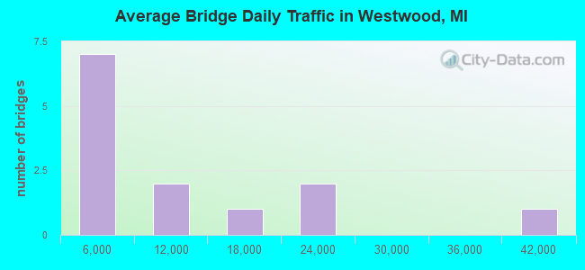
- National Bridge Inventory (NBI) Statistics
- 13Number of bridges
- 66ft / 20.4mTotal length
- 129,242Total average daily traffic
- 13,022Total average daily truck traffic
- National Bridge Inventory (NBI) Registered Bridges for Westwood
- No street view available for this location
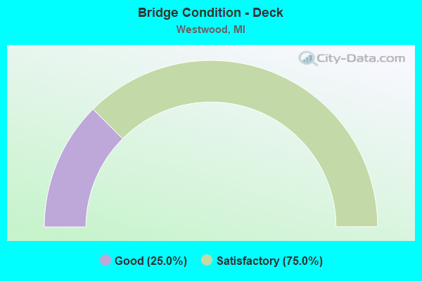
- Bridge Condition - Deck
- 25.0%Good
- 75.0%Satisfactory
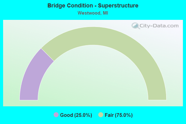
- Bridge Condition - Superstructure
- 25.0%Good
- 75.0%Fair
Find on map >> Show street view
Structure Number: 1089, Location: 1.9 MI N OF INDIANA STATE (Lat: 41.785439, Lng: -84.991503), Route carried "on" structure: County highway , Year Built: 1967, Status: Open, Structure Length: 9.51m (31.20ft), Average Daily Traffic: 340 (year 2007), Average Future Daily Traffic: 374 (year 2022), Design Load: H 15, Features Intersected: I-69, Facility Carried by Structure: SOUTHERN ROAD
Minimum Vertical Clearance: 30.48m (100.00ft), Kilometerpoint: 1.172, Lanes on structure: 2, Lanes under structure: 4, Owner: State Highway Agency, Approaching Roadway Width: 6.6m (21.7ft), Skew: 2 degrees, Material/Design: Steel, Design/Construction: Stringer/Multi-beam, Number Of Spans In Main Unit: 4, Length of Maximum Span: 28.0m (91.9ft), Curb or Sidewalk Widths: Left: 0.2m (0.7ft), Right: 0.2m (0.7ft), Curb-To-Curb Width: 7.8m (25.6ft), Out-to-Out Width: 9.5m (31.2ft)
Condition: Deck: Satisfactory, Superstructure: Fair, Substructure: Satisfactory, Operating Rating: 57.0 metric tons, Method Used To Determine Operating Rating: Load Factor (LF) rating reported by rating factor (RF) method using MS18 loading, Inventory Rating: 29.5 metric tons, Method Used To Determine Inventory Rating: Load Factor (LF) rating reported by rating factor (RF) method using MS18 loading, Structural Evaluation: Somewhat better than minimum adequacy, Deck Geometry: Somewhat better than minimum adequacy, Underclear: Equal to present minimum criteria, Approach Roadway Alignment: Equal to present desirable criteria, Designated Inspection Frequency: Every 24 months, Inspection Date: May 2021, Deck Structure Type: Concrete Cast-file-Place, Wearing Surface/Protective System: Wearing Surface: Other
Find on map >> Show street view
Structure Number: 4565, Location: 3.0 MI S OF ALLEGAN COL (Lat: 42.376228, Lng: -85.656517), Route carried "on" structure: US 131, Year Built: 1962, Status: Open, Structure Length: 3.35m (10.99ft), Average Daily Traffic: 18,604 (year 2007), Truck Traffic: 13%, Average Future Daily Traffic: 27,059 (year 2018), Design Load: HS 20, Features Intersected: D AVE
Minimum Vertical Clearance: 30.48m (100.00ft), Kilometerpoint: 29.045, Lanes on structure: 2, Lanes under structure: 2, Base Highway Network: Yes (Inventory Route: 339, Subroute: 6), Owner: State Highway Agency, Approaching Roadway Width: 12.5m (41.0ft), Material/Design: Prestressed concrete, Design/Construction: Stringer/Multi-beam, Number Of Spans In Main Unit: 3, Length of Maximum Span: 12.5m (41.0ft), Curb-To-Curb Width: 11.7m (38.4ft), Out-to-Out Width: 13.3m (43.6ft)
Condition: Deck: Satisfactory, Superstructure: Fair, Substructure: Satisfactory, Operating Rating: 52.5 metric tons, Method Used To Determine Operating Rating: Load Factor (LF) rating reported by rating factor (RF) method using MS18 loading, Inventory Rating: 31.4 metric tons, Method Used To Determine Inventory Rating: Load Factor (LF) rating reported by rating factor (RF) method using MS18 loading, Structural Evaluation: Somewhat better than minimum adequacy, Deck Geometry: Better than present minimum criteria, Underclear: High priority of corrective action, Approach Roadway Alignment: Equal to present desirable criteria, Designated Inspection Frequency: Every 24 months, Inspection Date: September 2020, Deck Structure Type: Concrete Cast-file-Place, Wearing Surface/Protective System: Wearing Surface: Latex Concrete
Find on map >> Show street view
Structure Number: 4566, Location: 3.0 MI S OF ALLEGAN COL (Lat: 42.376250, Lng: -85.655742), Route carried "on" structure: US 131, Year Built: 1962, Status: Open, Structure Length: 3.38m (11.09ft), Average Daily Traffic: 18,604 (year 2007), Truck Traffic: 13%, Average Future Daily Traffic: 27,059 (year 2018), Design Load: HS 20, Features Intersected: D AVE
Minimum Vertical Clearance: 30.48m (100.00ft), Kilometerpoint: 34.712, Lanes on structure: 2, Lanes under structure: 2, Base Highway Network: Yes (Inventory Route: 1, Subroute: 7), Owner: State Highway Agency, Approaching Roadway Width: 10.9m (35.8ft), Material/Design: Prestressed concrete, Design/Construction: Stringer/Multi-beam, Number Of Spans In Main Unit: 3, Length of Maximum Span: 12.5m (41.0ft), Curb-To-Curb Width: 11.7m (38.4ft), Out-to-Out Width: 13.3m (43.6ft)
Condition: Deck: Satisfactory, Superstructure: Fair, Substructure: Satisfactory, Operating Rating: 52.5 metric tons, Method Used To Determine Operating Rating: Load Factor (LF) rating reported by rating factor (RF) method using MS18 loading, Inventory Rating: 31.4 metric tons, Method Used To Determine Inventory Rating: Load Factor (LF) rating reported by rating factor (RF) method using MS18 loading, Structural Evaluation: Somewhat better than minimum adequacy, Deck Geometry: Better than present minimum criteria, Underclear: Meets minimum limits, Approach Roadway Alignment: Equal to present desirable criteria, Designated Inspection Frequency: Every 24 months, Inspection Date: September 2020, Deck Structure Type: Concrete Cast-file-Place, Wearing Surface/Protective System: Wearing Surface: Latex Concrete
Find on map >> Show street view
Structure Number: 461, Location: 2.0 MI E OF US-131 (Lat: 42.323886, Lng: -85.628800), Route carried "on" structure: Business US 131, Year Built: 1963, Year Reconstructed: 2000, Status: Open, Structure Length: 4.19m (13.75ft), Average Daily Traffic: 2,811 (year 2007), Truck Traffic: 9%, Average Future Daily Traffic: 3,630 (year 2018), Design Load: HS 20, Features Intersected: NICHOLS RD (14TH ST)
Minimum Vertical Clearance: 30.48m (100.00ft), Kilometerpoint: 6.236, Lanes on structure: 2, Lanes under structure: 2, Base Highway Network: Yes (, Subroute: 8), Owner: State Highway Agency, Approaching Roadway Width: 12.2m (40.0ft), Skew: 3 degrees, Material/Design: Prestressed concrete, Design/Construction: Stringer/Multi-beam, Number Of Spans In Main Unit: 3, Length of Maximum Span: 14.8m (48.6ft), Curb-To-Curb Width: 13.6m (44.6ft), Out-to-Out Width: 14.4m (47.2ft)
Condition: Deck: Good, Superstructure: Good, Substructure: Satisfactory, Operating Rating: 68.4 metric tons, Method Used To Determine Operating Rating: Load Factor (LF), Inventory Rating: 39.1 metric tons, Method Used To Determine Inventory Rating: Load Factor (LF), Structural Evaluation: Equal to present minimum criteria, Deck Geometry: Superior to present desirable criteria, Underclear: Somewhat better than minimum adequacy, Approach Roadway Alignment: Equal to present desirable criteria, Designated Inspection Frequency: Every 24 months, Inspection Date: October 2020, Deck Structure Type: Concrete Cast-file-Place, Wearing Surface/Protective System: Wearing Surface: Monolithic Concrete, Deck Protection: Epoxy Coated Reinforcing
Find on map >> Show street view
Structure Number: 4563, Location: AT N JCT US-131 BR (Lat: 42.329486, Lng: -85.663989), Route carried "under" structure: US 131, Year Built: 1963, Structure Length: 0. m, Average Daily Traffic: 13,065 (year 2007), Truck Traffic: 16%, Features Intersected: US-131 NB
Minimum Vertical Clearance: 5.56m (18.24ft), Kilometerpoint: 29.401, Lanes on structure: 2, Lanes under structure: 2, Material/Design: Steel, Design/Construction: Stringer/Multi-beam, Length of Maximum Span: 30.1m (98.8ft)
Find on map >> Show street view
Structure Number: 4564, Location: 1.5 MI N OF N JCT US-131 (Lat: 42.348697, Lng: -85.659211), Route carried "under" structure: US 131, Year Built: 1963, Structure Length: 0. m, Average Daily Traffic: 36,616 (year 2012), Truck Traffic: 10%, Features Intersected: US-131, Facility Carried by Structure: RAVINE ROAD
Minimum Vertical Clearance: 5.31m (17.42ft), Kilometerpoint: 31.610, Lanes on structure: 2, Lanes under structure: 4, Material/Design: Steel, Design/Construction: Stringer/Multi-beam, Length of Maximum Span: 27.4m (89.9ft)
Find on map >> Show street view
Structure Number: 4565, Location: 3.0 MI S OF ALLEGAN COL (Lat: 42.376228, Lng: -85.656517), Route carried "under" structure: County highway 3990, Year Built: 1962, Structure Length: 0. m, Average Daily Traffic: 7,462 (year 1994), Truck Traffic: 5%, Features Intersected: D AVE, Facility Carried by Structure: US-131 SB
Minimum Vertical Clearance: 4.90m (16.08ft), Kilometerpoint: 9.697, Lanes on structure: 2, Lanes under structure: 2, Material/Design: Prestressed concrete, Design/Construction: Stringer/Multi-beam, Length of Maximum Span: 12.5m (41.0ft)
Find on map >> Show street view
Structure Number: 4566, Location: 3.0 MI S OF ALLEGAN COL (Lat: 42.376250, Lng: -85.655742), Route carried "under" structure: County highway 3990, Year Built: 1962, Structure Length: 0. m, Average Daily Traffic: 7,462 (year 1994), Truck Traffic: 5%, Features Intersected: D AVE, Facility Carried by Structure: US-131 NB
Minimum Vertical Clearance: 4.57m (14.99ft), Kilometerpoint: 9.759, Lanes on structure: 2, Lanes under structure: 2, Material/Design: Prestressed concrete, Design/Construction: Stringer/Multi-beam, Length of Maximum Span: 12.5m (41.0ft)
Find on map >> Show street view
Structure Number: 4609, Location: 2.5 MI E OF US-131 (Lat: 42.317928, Lng: -85.619567), Route carried "under" structure: Business US 131, Year Built: 1964, Structure Length: 0. m, Average Daily Traffic: 5,622 (year 2007), Truck Traffic: 9%, Features Intersected: US-131 BR, Facility Carried by Structure: BARNEY RD (H AVE)
Minimum Vertical Clearance: 4.82m (15.81ft), Kilometerpoint: 5.227, Lanes on structure: 2, Lanes under structure: 4, Material/Design: Steel, Design/Construction: Stringer/Multi-beam, Length of Maximum Span: 37.1m (121.7ft)
Find on map >> Show street view
Structure Number: 461, Location: 2.0 MI E OF US-131 (Lat: 42.323886, Lng: -85.628800), Route carried "under" structure: County highway 2005, Year Built: 1963, Structure Length: 0. m, Average Daily Traffic: 4,632 (year 1997), Truck Traffic: 4%, Features Intersected: NICHOLS RD (14TH ST), Facility Carried by Structure: US-131 BR NB
Minimum Vertical Clearance: 5.46m (17.91ft), Kilometerpoint: 3.088, Lanes on structure: 2, Lanes under structure: 2, Material/Design: Prestressed concrete, Design/Construction: Stringer/Multi-beam, Length of Maximum Span: 14.8m (48.6ft)
Find on map >> Show street view
Structure Number: 4611, Location: 2.0 MI E OF US-131 (Lat: 42.323561, Lng: -85.628808), Route carried "under" structure: County highway , Year Built: 1963, Structure Length: 0. m, Average Daily Traffic: 4,632 (year 1997), Truck Traffic: 4%, Features Intersected: NICHOLS RD (14TH ST), Facility Carried by Structure: US-131 BR SB
Minimum Vertical Clearance: 5.23m (17.16ft), Kilometerpoint: 3.053, Lanes on structure: 2, Lanes under structure: 2, Material/Design: Prestressed concrete, Design/Construction: Stringer/Multi-beam, Length of Maximum Span: 14.9m (48.9ft)
Find on map >> Show street view
Structure Number: 4612, Location: 1.2 MI E OF US-131 (Lat: 42.326194, Lng: -85.649275), Route carried "under" structure: County highway , Year Built: 1963, Structure Length: 0. m, Average Daily Traffic: 4,696 (year 1995), Truck Traffic: 6%, Features Intersected: RAVINE ROAD, Facility Carried by Structure: US-131 BR SB
Minimum Vertical Clearance: 5.13m (16.83ft), Kilometerpoint: 7.392, Lanes on structure: 2, Lanes under structure: 2, Material/Design: Prestressed concrete, Design/Construction: Stringer/Multi-beam, Length of Maximum Span: 13.4m (44.0ft)
Find on map >> Show street view
Structure Number: 4613, Location: 1.2 MI E OF US-131 (Lat: 42.326508, Lng: -85.649311), Route carried "under" structure: County highway , Year Built: 1963, Structure Length: 0. m, Average Daily Traffic: 4,696 (year 1995), Truck Traffic: 6%, Features Intersected: RAVINE ROAD, Facility Carried by Structure: US-131 BR NB
Minimum Vertical Clearance: 4.78m (15.68ft), Kilometerpoint: 7.427, Lanes on structure: 2, Lanes under structure: 2, Material/Design: Prestressed concrete, Design/Construction: Stringer/Multi-beam, Length of Maximum Span: 13.1m (43.0ft)