Bridge Statistics for White Hall, Alabama (AL)
Condition, Traffic, Stress, Structural Evaluation, Project Costs
- National Bridge Inventory (NBI) Statistics
- 12Number of bridges
- 302ft / 92.1mTotal length
- $27,866,000Total costs
- 44,400Total average daily traffic
- 5,276Total average daily truck traffic
- 59,625Total future (year 2033) average daily traffic
- National Bridge Inventory (NBI) Registered Bridges for White Hall
- No street view available for this location
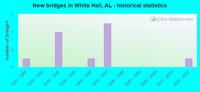
- New bridges - historical statistics
- 11920-1929
- 41940-1949
- 11960-1969
- 51970-1979
- 12020-2022


- Bridge Condition - Deck
- 8.3%Very good
- 16.7%Good
- 58.3%Satisfactory
- 8.3%Fair
- 8.3%Poor

- Bridge Condition - Superstructure
- 8.3%Very good
- 8.3%Good
- 75.0%Satisfactory
- 8.3%Fair

- Bridge Condition - Substructure
- 8.3%Very good
- 41.7%Good
- 41.7%Satisfactory
- 8.3%Poor

- Bridge Condition - Channel
- 33.3%Good
- 58.3%Satisfactory
- 8.3%Fair
Find on map >> Show street view
Structure Number: 292, Location: BROAD ST 400'E OF US 11 (Lat: 34.263200, Lng: -85.862100), Route carried "on" structure: City street , Year Built: 1925, Status: Posted for load, Structure Length: 3.29m (10.79ft), Average Daily Traffic: 70 (year 2021), Average Future Daily Traffic: 90 (year 2041), Design Load: H 10, Features Intersected: LITTLE WILLS CREEK, Facility Carried by Structure: BROAD ST
Minimum Vertical Clearance: 30+ m (98+ ft), Kilometerpoint: 0.010, Lanes on structure: 1, Owner: City or Municipal Highway Agency, Approaching Roadway Width: 3.0m (9.8ft), Skew: 3 degrees, Material/Design: Steel, Design/Construction: Stringer/Multi-beam, Number Of Spans In Main Unit: 4, Length of Maximum Span: 8.2m (26.9ft), Curb or Sidewalk Widths: Left: 0.2m (0.7ft), Right: 0.2m (0.7ft), Curb-To-Curb Width: 3.3m (10.8ft), Out-to-Out Width: 3.7m (12.1ft)
Condition: Deck: Poor, Superstructure: Satisfactory, Substructure: Poor, Channel: Fair, Operating Rating: 2.7 metric tons, Method Used To Determine Operating Rating: Load Factor (LF), Inventory Rating: 1.8 metric tons, Method Used To Determine Inventory Rating: Load Factor (LF), Structural Evaluation: High priority of replacement, Deck Geometry: High priority of replacement, Waterway Adequacy: Equal to present minimum criteria, Approach Roadway Alignment: Equal to present minimum criteria, Bridge Posting: Required (Relationship of Operating Rating to Maximum Legal Load: > 39.9% below), Length Of Structure Improvement: 4.17m (13.68ft), Designated Inspection Frequency: Every 24 months, Other Special Inspection Frequency: Every 12 months, Inspection Date: April 2020, Other Special Inspection Date: April 2021, Bridge Improvement Cost: $343,000, Roadway Improvement Cost: $34,000, Total Project Cost: $377,000 ( Estimate for 2022), Deck Structure Type: Concrete Cast-file-Place
Find on map >> Show street view
Structure Number: 2918, Location: 5.3 MI. W. OF LOWNDESBORO (Lat: 32.265781, Lng: -86.692128), Route carried "on" structure: US 80, Year Built: 1946, Status: Closed, Structure Length: 6.22m (20.41ft), Average Daily Traffic: 4,275 (year 2013), Truck Traffic: 12%, Average Future Daily Traffic: 5,590 (year 2033), Design Load: H 20, Features Intersected: BIG SWAMP CREEK RELIEF 1
Minimum Vertical Clearance: 30+ m (98+ ft), Kilometerpoint: 173.851, Lanes on structure: 2, Base Highway Network: Yes, Owner: State Highway Agency, Approaching Roadway Width: 12.2m (40.0ft), Skew: 10 degrees, Material/Design: Concrete, Design/Construction: Tee Beam, Number Of Spans In Main Unit: 6, Length of Maximum Span: 10.4m (34.1ft), Curb-To-Curb Width: 7.9m (25.9ft), Out-to-Out Width: 8.8m (28.9ft)
Condition: Deck: Satisfactory, Superstructure: Satisfactory, Substructure: Satisfactory, Channel: Good, Waterway Adequacy: Equal to present minimum criteria, Approach Roadway Alignment: Better than present minimum criteria, Bridge Posting: Required (Relationship of Operating Rating to Maximum Legal Load: > 39.9% below), Length Of Structure Improvement: 7.26m (23.82ft), Designated Inspection Frequency: Every 24 months, Inspection Date: December 2019, Bridge Improvement Cost: $1,394,000, Roadway Improvement Cost: $139,000, Total Project Cost: $1,533,000 ( Estimate for 2022), Deck Structure Type: Concrete Cast-file-Place
Find on map >> Show street view
Structure Number: 2919, Location: 5.0 MI. W. OF LOWNDESBORO (Lat: 32.264500, Lng: -86.688283), Route carried "on" structure: US 80, Year Built: 1946, Status: Open, Structure Length: 6.22m (20.41ft), Average Daily Traffic: 4,275 (year 2013), Truck Traffic: 12%, Average Future Daily Traffic: 5,590 (year 2033), Design Load: H 20, Features Intersected: BIG SWAMP CREEK RELIEF 2
Minimum Vertical Clearance: 30+ m (98+ ft), Kilometerpoint: 174.244, Lanes on structure: 2, Base Highway Network: Yes, Owner: State Highway Agency, Approaching Roadway Width: 12.2m (40.0ft), Skew: 10 degrees, Material/Design: Concrete, Design/Construction: Tee Beam, Number Of Spans In Main Unit: 6, Length of Maximum Span: 10.4m (34.1ft), Curb-To-Curb Width: 7.9m (25.9ft), Out-to-Out Width: 8.8m (28.9ft)
Condition: Deck: Satisfactory, Superstructure: Satisfactory, Substructure: Satisfactory, Channel: Satisfactory, Operating Rating: 37.5 metric tons, Method Used To Determine Operating Rating: Load Factor (LF), Inventory Rating: 22.4 metric tons, Method Used To Determine Inventory Rating: Load Factor (LF), Structural Evaluation: Somewhat better than minimum adequacy, Deck Geometry: High priority of replacement, Waterway Adequacy: Superior to present desirable criteria, Approach Roadway Alignment: Better than present minimum criteria, Length Of Structure Improvement: 7.26m (23.82ft), Designated Inspection Frequency: Every 24 months, Inspection Date: December 2021, Bridge Improvement Cost: $1,394,000, Roadway Improvement Cost: $139,000, Total Project Cost: $1,533,000 ( Estimate for 2022), Deck Structure Type: Concrete Cast-file-Place
Find on map >> Show street view
Structure Number: 292, Location: 4.7 MI. W. OF LOWNDESBORO (Lat: 32.262872, Lng: -86.683306), Route carried "on" structure: US 80, Year Built: 1946, Status: Open, Structure Length: 5.18m (16.99ft), Average Daily Traffic: 4,275 (year 2013), Truck Traffic: 12%, Average Future Daily Traffic: 5,590 (year 2033), Design Load: H 20, Features Intersected: BIG SWAMP CREEK RELIEF
Minimum Vertical Clearance: 30+ m (98+ ft), Kilometerpoint: 174.747, Lanes on structure: 2, Base Highway Network: Yes, Owner: State Highway Agency, Approaching Roadway Width: 12.2m (40.0ft), Skew: 10 degrees, Material/Design: Concrete, Design/Construction: Tee Beam, Number Of Spans In Main Unit: 5, Length of Maximum Span: 10.4m (34.1ft), Curb-To-Curb Width: 7.9m (25.9ft), Out-to-Out Width: 8.8m (28.9ft)
Condition: Deck: Satisfactory, Superstructure: Satisfactory, Substructure: Satisfactory, Channel: Satisfactory, Operating Rating: 37.5 metric tons, Method Used To Determine Operating Rating: Load Factor (LF), Inventory Rating: 22.4 metric tons, Method Used To Determine Inventory Rating: Load Factor (LF), Structural Evaluation: Somewhat better than minimum adequacy, Deck Geometry: High priority of replacement, Waterway Adequacy: Superior to present desirable criteria, Approach Roadway Alignment: Better than present minimum criteria, Length Of Structure Improvement: 6.20m (20.34ft), Designated Inspection Frequency: Every 24 months, Underwater Inspection Frequency: Every 24 months, Inspection Date: December 2021, Underwater Inspection Date: December 2021, Bridge Improvement Cost: $1,191,000, Roadway Improvement Cost: $119,000, Total Project Cost: $1,310,000 ( Estimate for 2019), Deck Structure Type: Concrete Cast-file-Place
Find on map >> Show street view
Structure Number: 2921, Location: 4.5 MI. W. OF LOWNDESBORO (Lat: 32.261878, Lng: -86.680203), Route carried "on" structure: US 80, Year Built: 1946, Status: Open, Structure Length: 5.18m (16.99ft), Average Daily Traffic: 4,275 (year 2013), Truck Traffic: 12%, Average Future Daily Traffic: 5,590 (year 2033), Design Load: H 20, Features Intersected: BIG SWAMP CREEK RELIEF
Minimum Vertical Clearance: 30+ m (98+ ft), Kilometerpoint: 175.064, Lanes on structure: 2, Base Highway Network: Yes, Owner: State Highway Agency, Approaching Roadway Width: 12.2m (40.0ft), Skew: 10 degrees, Material/Design: Concrete, Design/Construction: Tee Beam, Number Of Spans In Main Unit: 5, Length of Maximum Span: 10.4m (34.1ft), Curb-To-Curb Width: 7.9m (25.9ft), Out-to-Out Width: 8.8m (28.9ft)
Condition: Deck: Satisfactory, Superstructure: Satisfactory, Substructure: Satisfactory, Channel: Satisfactory, Operating Rating: 37.5 metric tons, Method Used To Determine Operating Rating: Load Factor (LF), Inventory Rating: 22.4 metric tons, Method Used To Determine Inventory Rating: Load Factor (LF), Structural Evaluation: Somewhat better than minimum adequacy, Deck Geometry: High priority of replacement, Waterway Adequacy: Superior to present desirable criteria, Approach Roadway Alignment: Better than present minimum criteria, Length Of Structure Improvement: 6.20m (20.34ft), Designated Inspection Frequency: Every 24 months, Inspection Date: December 2021, Bridge Improvement Cost: $1,191,000, Roadway Improvement Cost: $119,000, Total Project Cost: $1,310,000 ( Estimate for 2022), Deck Structure Type: Concrete Cast-file-Place
Find on map >> Show street view
Structure Number: 7028, Location: 2MI EAST OF CO23 CO40 INT (Lat: 32.328158, Lng: -86.675808), Route carried "on" structure: County highway 40, Year Built: 1960, Status: Posted for load, Structure Length: 4.14m (13.58ft), Average Daily Traffic: 610 (year 2015), Truck Traffic: 5%, Average Future Daily Traffic: 650 (year 2035), Design Load: H 20, Features Intersected: CYPRESS CREEK
Minimum Vertical Clearance: 30+ m (98+ ft), Kilometerpoint: 0.010, Lanes on structure: 2, Owner: County Highway Agency, Approaching Roadway Width: 6.1m (20.0ft), Material/Design: Concrete, Design/Construction: Tee Beam, Number Of Spans In Main Unit: 4, Length of Maximum Span: 10.4m (34.1ft), Curb-To-Curb Width: 6.6m (21.7ft), Out-to-Out Width: 7.1m (23.3ft)
Condition: Deck: Fair, Superstructure: Fair, Substructure: Satisfactory, Channel: Good, Operating Rating: 37.6 metric tons, Method Used To Determine Operating Rating: Load Factor (LF), Inventory Rating: 22.6 metric tons, Method Used To Determine Inventory Rating: Load Factor (LF), Structural Evaluation: Somewhat better than minimum adequacy, Deck Geometry: High priority of corrective action, Waterway Adequacy: Better than present minimum criteria, Approach Roadway Alignment: Better than present minimum criteria, Bridge Posting: Required (Relationship of Operating Rating to Maximum Legal Load: 0.1 - 9.9% below), Length Of Structure Improvement: 5.10m (16.73ft), Designated Inspection Frequency: Every 24 months, Other Special Inspection Frequency: Every 12 months, Inspection Date: April 2021, Other Special Inspection Date: April 2021, Bridge Improvement Cost: $804,000, Roadway Improvement Cost: $80,000, Total Project Cost: $884,000 ( Estimate for 2022), Deck Structure Type: Concrete Cast-file-Place
Find on map >> Show street view
Structure Number: 11603, Location: 5.5 MI.W.OF LOWNDESBORO (Lat: 32.266839, Lng: -86.694075), Route carried "on" structure: US 80, Year Built: 1976, Status: Open, Structure Length: 18.01m (59.09ft), Average Daily Traffic: 4,275 (year 2013), Truck Traffic: 12%, Average Future Daily Traffic: 5,590 (year 2033), Design Load: HS 20, Features Intersected: BIG SWAMP CREEK
Minimum Vertical Clearance: 30+ m (98+ ft), Kilometerpoint: 173.516, Lanes on structure: 2, Base Highway Network: Yes, Owner: State Highway Agency, Approaching Roadway Width: 12.2m (40.0ft), Skew: 10 degrees, Material/Design: Steel, Design/Construction: Stringer/Multi-beam, Number Of Spans In Main Unit: 1, Number Of Approach Spans: 15, Length of Maximum Span: 24.7m (81.0ft), Curb-To-Curb Width: 11.9m (39.0ft), Out-to-Out Width: 12.8m (42.0ft)
Condition: Deck: Satisfactory, Superstructure: Satisfactory, Substructure: Good, Channel: Satisfactory, Operating Rating: 49.3 metric tons, Method Used To Determine Operating Rating: Load Factor (LF), Inventory Rating: 29.7 metric tons, Method Used To Determine Inventory Rating: Load Factor (LF), Structural Evaluation: Equal to present minimum criteria, Deck Geometry: Better than present minimum criteria, Waterway Adequacy: Superior to present desirable criteria, Approach Roadway Alignment: Better than present minimum criteria, Length Of Structure Improvement: 18.69m (61.32ft), Designated Inspection Frequency: Every 24 months, Inspection Date: December 2021, Bridge Improvement Cost: $5,383,000, Roadway Improvement Cost: $538,000, Total Project Cost: $5,921,000 ( Estimate for 2022), Deck Structure Type: Concrete Cast-file-Place
Find on map >> Show street view
Structure Number: 11604, Location: 5.3 MI. W. OF LOWNDESBORO (Lat: 32.266158, Lng: -86.691903), Route carried "on" structure: US 80, Year Built: 1976, Status: Open, Structure Length: 6.22m (20.41ft), Average Daily Traffic: 4,275 (year 2013), Truck Traffic: 12%, Average Future Daily Traffic: 5,590 (year 2033), Design Load: HS 20, Features Intersected: BIG SWAMP CREEK RELIEF 1
Minimum Vertical Clearance: 30+ m (98+ ft), Kilometerpoint: 173.851, Lanes on structure: 2, Base Highway Network: Yes, Owner: State Highway Agency, Approaching Roadway Width: 12.2m (40.0ft), Skew: 10 degrees, Material/Design: Concrete, Design/Construction: Tee Beam, Number Of Spans In Main Unit: 6, Length of Maximum Span: 10.4m (34.1ft), Curb-To-Curb Width: 11.9m (39.0ft), Out-to-Out Width: 12.8m (42.0ft)
Condition: Deck: Good, Superstructure: Good, Substructure: Good, Channel: Good, Operating Rating: 40.1 metric tons, Method Used To Determine Operating Rating: Load Factor (LF), Inventory Rating: 23.1 metric tons, Method Used To Determine Inventory Rating: Load Factor (LF), Structural Evaluation: Equal to present minimum criteria, Deck Geometry: Better than present minimum criteria, Waterway Adequacy: Superior to present desirable criteria, Approach Roadway Alignment: Better than present minimum criteria, Length Of Structure Improvement: 7.26m (23.82ft), Designated Inspection Frequency: Every 24 months, Inspection Date: December 2021, Bridge Improvement Cost: $2,091,000, Roadway Improvement Cost: $209,000, Total Project Cost: $2,300,000 ( Estimate for 2022), Deck Structure Type: Concrete Cast-file-Place
Find on map >> Show street view
Structure Number: 11605, Location: 5.0 MI. W. OF LOWNDESBORO (Lat: 32.264878, Lng: -86.687986), Route carried "on" structure: US 80, Year Built: 1976, Status: Open, Structure Length: 8.29m (27.20ft), Average Daily Traffic: 4,275 (year 2013), Truck Traffic: 12%, Average Future Daily Traffic: 5,590 (year 2033), Design Load: HS 20, Features Intersected: BIG SWAMP CREEK RELIEF 2
Minimum Vertical Clearance: 30+ m (98+ ft), Kilometerpoint: 174.232, Lanes on structure: 2, Base Highway Network: Yes, Owner: State Highway Agency, Approaching Roadway Width: 12.2m (40.0ft), Skew: 10 degrees, Material/Design: Concrete, Design/Construction: Tee Beam, Number Of Spans In Main Unit: 8, Length of Maximum Span: 10.4m (34.1ft), Curb-To-Curb Width: 11.9m (39.0ft), Out-to-Out Width: 12.8m (42.0ft)
Condition: Deck: Satisfactory, Superstructure: Satisfactory, Substructure: Good, Channel: Satisfactory, Operating Rating: 49.3 metric tons, Method Used To Determine Operating Rating: Load Factor (LF), Inventory Rating: 29.7 metric tons, Method Used To Determine Inventory Rating: Load Factor (LF), Structural Evaluation: Equal to present minimum criteria, Deck Geometry: Better than present minimum criteria, Waterway Adequacy: Superior to present desirable criteria, Approach Roadway Alignment: Better than present minimum criteria, Length Of Structure Improvement: 9.29m (30.48ft), Designated Inspection Frequency: Every 24 months, Inspection Date: December 2021, Bridge Improvement Cost: $2,675,000, Roadway Improvement Cost: $268,000, Total Project Cost: $2,943,000 ( Estimate for 2022), Deck Structure Type: Concrete Cast-file-Place
Find on map >> Show street view
Structure Number: 11606, Location: 4.7 MI. W. OF LOWNDESBORO (Lat: 32.263242, Lng: -86.683083), Route carried "on" structure: US 80, Year Built: 1976, Status: Open, Structure Length: 5.18m (16.99ft), Average Daily Traffic: 4,275 (year 2013), Truck Traffic: 12%, Average Future Daily Traffic: 5,590 (year 2033), Design Load: HS 20, Features Intersected: BIG SWAMP CREEK RELIEF
Minimum Vertical Clearance: 30+ m (98+ ft), Kilometerpoint: 174.747, Lanes on structure: 2, Base Highway Network: Yes, Owner: State Highway Agency, Approaching Roadway Width: 12.2m (40.0ft), Skew: 10 degrees, Material/Design: Concrete, Design/Construction: Tee Beam, Number Of Spans In Main Unit: 5, Length of Maximum Span: 10.4m (34.1ft), Curb-To-Curb Width: 11.9m (39.0ft), Out-to-Out Width: 12.8m (42.0ft)
Condition: Deck: Good, Superstructure: Satisfactory, Substructure: Good, Channel: Satisfactory, Operating Rating: 49.3 metric tons, Method Used To Determine Operating Rating: Load Factor (LF), Inventory Rating: 29.7 metric tons, Method Used To Determine Inventory Rating: Load Factor (LF), Structural Evaluation: Equal to present minimum criteria, Deck Geometry: Better than present minimum criteria, Waterway Adequacy: Superior to present desirable criteria, Approach Roadway Alignment: Better than present minimum criteria, Length Of Structure Improvement: 6.20m (20.34ft), Designated Inspection Frequency: Every 24 months, Inspection Date: December 2021, Bridge Improvement Cost: $1,786,000, Roadway Improvement Cost: $179,000, Total Project Cost: $1,965,000 ( Estimate for 2022), Deck Structure Type: Concrete Cast-file-Place
Find on map >> Show street view
Structure Number: 11607, Location: 4.5 MI. W. OF LOWNDESBORO (Lat: 32.262364, Lng: -86.679925), Route carried "on" structure: US 80, Year Built: 1976, Status: Open, Structure Length: 6.22m (20.41ft), Average Daily Traffic: 4,275 (year 2013), Truck Traffic: 12%, Average Future Daily Traffic: 5,590 (year 2033), Design Load: HS 20, Features Intersected: BIG SWAMP CREEK RELIEF
Minimum Vertical Clearance: 30+ m (98+ ft), Kilometerpoint: 175.064, Lanes on structure: 2, Base Highway Network: Yes, Owner: State Highway Agency, Approaching Roadway Width: 12.2m (40.0ft), Skew: 10 degrees, Material/Design: Concrete, Design/Construction: Tee Beam, Number Of Spans In Main Unit: 6, Length of Maximum Span: 10.4m (34.1ft), Curb-To-Curb Width: 11.9m (39.0ft), Out-to-Out Width: 12.8m (42.0ft)
Condition: Deck: Satisfactory, Superstructure: Satisfactory, Substructure: Good, Channel: Satisfactory, Operating Rating: 49.3 metric tons, Method Used To Determine Operating Rating: Load Factor (LF), Inventory Rating: 29.7 metric tons, Method Used To Determine Inventory Rating: Load Factor (LF), Structural Evaluation: Equal to present minimum criteria, Deck Geometry: Better than present minimum criteria, Waterway Adequacy: Superior to present desirable criteria, Approach Roadway Alignment: Better than present minimum criteria, Length Of Structure Improvement: 7.26m (23.82ft), Designated Inspection Frequency: Every 24 months, Inspection Date: December 2021, Bridge Improvement Cost: $2,091,000, Roadway Improvement Cost: $209,000, Total Project Cost: $2,300,000 ( Estimate for 2022), Deck Structure Type: Concrete Cast-file-Place
Find on map >> Show street view
Structure Number: 21427, Location: 5.5mi.W of Lowndesborrow (Lat: 34.621992, Lng: -86.587492), Route carried "on" structure: US 80, Year Built: 2020, Status: Open, Structure Length: 17.98m (58.99ft), Average Daily Traffic: 5,245 (year 2019), Truck Traffic: 12%, Average Future Daily Traffic: 8,575 (year 2039), Design Load: HL 93, Features Intersected: Big Swamp Creek
Minimum Vertical Clearance: 30.48m (100.00ft), Kilometerpoint: 173.515, Lanes on structure: 2, Base Highway Network: Yes, Owner: State Highway Agency, Approaching Roadway Width: 12.2m (40.0ft), Skew: 10 degrees, Material/Design: Prestressed concrete, Design/Construction: Stringer/Multi-beam, Number Of Spans In Main Unit: 5, Length of Maximum Span: 38.1m (125.0ft), Curb-To-Curb Width: 11.9m (39.0ft), Out-to-Out Width: 12.0m (39.4ft)
Condition: Deck: Very good, Superstructure: Very good, Substructure: Very good, Channel: Good, Operating Rating: 88.9 metric tons, Method Used To Determine Operating Rating: Load and Resistance Factor (LRFR), Inventory Rating: 58.2 metric tons, Method Used To Determine Inventory Rating: Load and Resistance Factor (LRFR), Structural Evaluation: Equal to present desirable criteria, Deck Geometry: Better than present minimum criteria, Waterway Adequacy: Better than present minimum criteria, Approach Roadway Alignment: Better than present minimum criteria, Length Of Structure Improvement: 18.66m (61.22ft), Designated Inspection Frequency: Every 24 months, Inspection Date: November 2020, Bridge Improvement Cost: $4,991,000, Roadway Improvement Cost: $499,000, Total Project Cost: $5,490,000 ( Estimate for 2022), Deck Structure Type: Concrete Cast-file-Place