Bridge Statistics for Whitehall, Montana (MT)
Condition, Traffic, Stress, Structural Evaluation, Project Costs
- National Bridge Inventory (NBI) Statistics
- 14Number of bridges
- 118ft / 35.8mTotal length
- 46,541Total average daily traffic
- 7,438Total average daily truck traffic
- National Bridge Inventory (NBI) Registered Bridges for Whitehall
- No street view available for this location
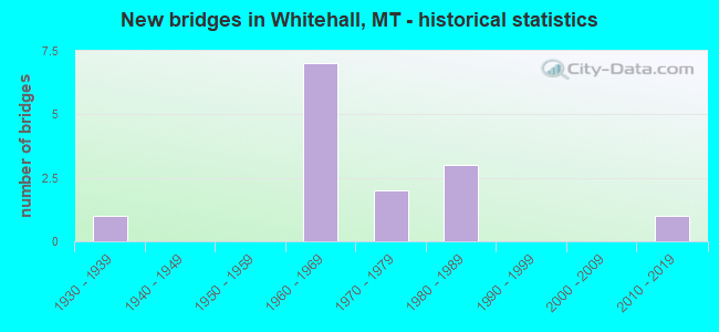
- New bridges - historical statistics
- 11930-1939
- 71960-1969
- 21970-1979
- 31980-1989
- 12010-2019


- Bridge Condition - Deck
- 70.0%Good
- 20.0%Satisfactory
- 10.0%Fair

- Bridge Condition - Superstructure
- 80.0%Good
- 10.0%Satisfactory
- 10.0%Fair

- Bridge Condition - Substructure
- 40.0%Good
- 30.0%Satisfactory
- 30.0%Fair

- Bridge Condition - Channel
- 12.5%Very good
- 25.0%Good
- 50.0%Satisfactory
- 12.5%Fair
Find on map >> Show street view
Structure Number: 5943, Location: 1M W WHITEHALL (Lat: 45.869528, Lng: -112.111669), Route carried "on" structure: State highway 55, Year Built: 2018, Status: Open, Structure Length: 4.27m (14.01ft), Average Daily Traffic: 2,629 (year 2020), Truck Traffic: 2%, Average Future Daily Traffic: 2,760 (year 2040), Design Load: HL 93, Features Intersected: PIPESTONE CREEK
Minimum Vertical Clearance: 30+ m (98+ ft), Kilometerpoint: 19.167, Lanes on structure: 2, Base Highway Network: Yes, Owner: State Highway Agency, Approaching Roadway Width: 7.3m (24.0ft), Material/Design: Prestressed concrete, Design/Construction: Stringer/Multi-beam, Number Of Spans In Main Unit: 3, Length of Maximum Span: 14.4m (47.2ft), Curb-To-Curb Width: 12.0m (39.4ft), Out-to-Out Width: 12.8m (42.0ft)
Condition: Deck: Good, Superstructure: Good, Substructure: Good, Channel: Good, Operating Rating: 45.4 metric tons, Method Used To Determine Operating Rating: Load and Resistance Factor (LRFR), Inventory Rating: 26.3 metric tons, Method Used To Determine Inventory Rating: Load and Resistance Factor (LRFR), Structural Evaluation: Equal to present minimum criteria, Deck Geometry: Somewhat better than minimum adequacy, Waterway Adequacy: Better than present minimum criteria, Approach Roadway Alignment: Better than present minimum criteria, Designated Inspection Frequency: Every 24 months, Inspection Date: July 2020, Deck Structure Type: Concrete Cast-file-Place, Wearing Surface/Protective System: Deck Protection: Epoxy Coated Reinforcing
Find on map >> Show street view
Structure Number: 7054, Location: 1M W WHITEHALL (Lat: 45.870119, Lng: -112.114389), Route carried "on" structure: County highway 22516, Year Built: 1930, Status: Open, Structure Length: 0.75m (2.46ft), Average Daily Traffic: 100 (year 2022), Truck Traffic: 3%, Average Future Daily Traffic: 100 (year 2037), Design Load: HL 93, Features Intersected: PIPESTONE CREEK, Facility Carried by Structure: CAPP LANE
Minimum Vertical Clearance: 30+ m (98+ ft), Kilometerpoint: 0.317, Lanes on structure: 2, Owner: County Highway Agency, Approaching Roadway Width: 5.5m (18.0ft), Material/Design: Concrete, Design/Construction: Slab, Number Of Spans In Main Unit: 1, Length of Maximum Span: 6.6m (21.7ft), Curb-To-Curb Width: 4.9m (16.1ft), Out-to-Out Width: 6.7m (22.0ft)
Condition: Deck: Fair, Superstructure: Fair, Substructure: Satisfactory, Channel: Satisfactory, Operating Rating: 32.7 metric tons, Method Used To Determine Operating Rating: Field evaluation and documented engineering judgment, Inventory Rating: 32.7 metric tons, Method Used To Determine Inventory Rating: Field evaluation and documented engineering judgment, Structural Evaluation: Somewhat better than minimum adequacy, Waterway Adequacy: Equal to present minimum criteria, Approach Roadway Alignment: Meets minimum limits, Designated Inspection Frequency: Every 24 months, Inspection Date: September 2021, Deck Structure Type: Concrete Cast-file-Place, Wearing Surface/Protective System: Wearing Surface: Bituminous
Find on map >> Show street view
Structure Number: I00090249+00261, Location: WHITEHALL (Lat: 45.877589, Lng: -112.102031), Route carried "on" structure: Interstate 90, Year Built: 1966, Status: Open, Structure Length: 3.93m (12.89ft), Average Daily Traffic: 8,629 (year 2020), Truck Traffic: 18%, Average Future Daily Traffic: 9,060 (year 2040), Design Load: HS 20, Features Intersected: INT WHITEHALL
Minimum Vertical Clearance: 30+ m (98+ ft), Kilometerpoint: 397.854, Lanes on structure: 2, Lanes under structure: 2, Base Highway Network: Yes, Owner: State Highway Agency, Approaching Roadway Width: 11.6m (38.1ft), Skew: 2 degrees, Material/Design: Prestressed concrete, Design/Construction: Stringer/Multi-beam, Number Of Spans In Main Unit: 3, Length of Maximum Span: 15.8m (51.8ft), Curb-To-Curb Width: 11.6m (38.1ft), Out-to-Out Width: 12.1m (39.7ft)
Condition: Deck: Good, Superstructure: Good, Substructure: Satisfactory, Operating Rating: 59.9 metric tons, Method Used To Determine Operating Rating: Load and Resistance Factor (LRFR), Inventory Rating: 46.3 metric tons, Method Used To Determine Inventory Rating: Load and Resistance Factor (LRFR), Structural Evaluation: Equal to present minimum criteria, Deck Geometry: Equal to present minimum criteria, Underclear: High priority of corrective action, Approach Roadway Alignment: Equal to present desirable criteria, Designated Inspection Frequency: Every 24 months, Inspection Date: October 2021, Deck Structure Type: Concrete Cast-file-Place
Find on map >> Show street view
Structure Number: I00090249+00262, Location: WHITEHALL (Lat: 45.877889, Lng: -112.102075), Route carried "on" structure: Interstate 90, Year Built: 1966, Status: Open, Structure Length: 3.93m (12.89ft), Average Daily Traffic: 8,716 (year 2020), Truck Traffic: 21%, Average Future Daily Traffic: 9,413 (year 2040), Design Load: HS 20, Features Intersected: INT WHITEHALL
Minimum Vertical Clearance: 30+ m (98+ ft), Kilometerpoint: 398.033, Lanes on structure: 2, Lanes under structure: 2, Base Highway Network: Yes, Owner: State Highway Agency, Approaching Roadway Width: 11.6m (38.1ft), Skew: 2 degrees, Material/Design: Prestressed concrete, Design/Construction: Stringer/Multi-beam, Number Of Spans In Main Unit: 3, Length of Maximum Span: 15.8m (51.8ft), Curb-To-Curb Width: 11.6m (38.1ft), Out-to-Out Width: 12.1m (39.7ft)
Condition: Deck: Good, Superstructure: Good, Substructure: Good, Operating Rating: 59.9 metric tons, Method Used To Determine Operating Rating: Load and Resistance Factor (LRFR), Inventory Rating: 46.3 metric tons, Method Used To Determine Inventory Rating: Load and Resistance Factor (LRFR), Structural Evaluation: Better than present minimum criteria, Deck Geometry: Equal to present minimum criteria, Underclear: High priority of corrective action, Approach Roadway Alignment: Equal to present desirable criteria, Designated Inspection Frequency: Every 24 months, Inspection Date: October 2021, Deck Structure Type: Concrete Cast-file-Place
Find on map >> Show street view
Structure Number: I00090249+04001, Location: 1M E WHITEHALL (Lat: 45.876667, Lng: -112.093972), Route carried "on" structure: Interstate 90, Year Built: 1965, Status: Open, Structure Length: 0.90m (2.95ft), Average Daily Traffic: 8,716 (year 2020), Truck Traffic: 21%, Average Future Daily Traffic: 9,413 (year 2040), Design Load: HS 20, Features Intersected: WHITETAIL CREEK
Minimum Vertical Clearance: 30+ m (98+ ft), Kilometerpoint: 398.486, Lanes on structure: 4, Owner: State Highway Agency, Approaching Roadway Width: 23.6m (77.4ft), Skew: 10 degrees, Material/Design: Steel, Design/Construction: Culvert, Number Of Spans In Main Unit: 2, Length of Maximum Span: 9.0m (29.5ft)
Condition: Channel: Good, Culverts: Satisfactory, Structural Evaluation: Equal to present minimum criteria, Waterway Adequacy: Better than present minimum criteria, Approach Roadway Alignment: Equal to present desirable criteria, Designated Inspection Frequency: Every 24 months, Inspection Date: Febuary 2022
Find on map >> Show street view
Structure Number: L22120000+01601, Location: WHITEHALL (Lat: 45.876483, Lng: -112.087664), Route carried "on" structure: ServiceCounty highway 22120, Year Built: 1966, Status: Open, Structure Length: 8.38m (27.49ft), Average Daily Traffic: 100 (year 2022), Truck Traffic: 3%, Average Future Daily Traffic: 100 (year 2037), Design Load: HS 15, Features Intersected: SEP I 90 002, Facility Carried by Structure: PAUL GULCH RD
Minimum Vertical Clearance: 30+ m (98+ ft), Kilometerpoint: 0.251, Lanes on structure: 2, Lanes under structure: 4, Owner: State Highway Agency, Approaching Roadway Width: 7.9m (25.9ft), Material/Design: Prestressed concrete, Design/Construction: Stringer/Multi-beam, Number Of Spans In Main Unit: 4, Length of Maximum Span: 22.9m (75.1ft), Curb-To-Curb Width: 7.9m (25.9ft), Out-to-Out Width: 8.9m (29.2ft)
Condition: Deck: Satisfactory, Superstructure: Satisfactory, Substructure: Good, Operating Rating: 45.4 metric tons, Method Used To Determine Operating Rating: Load and Resistance Factor (LRFR), Inventory Rating: 27.2 metric tons, Method Used To Determine Inventory Rating: Load and Resistance Factor (LRFR), Structural Evaluation: Equal to present minimum criteria, Deck Geometry: Equal to present minimum criteria, Underclear: High priority of corrective action, Approach Roadway Alignment: Equal to present minimum criteria, Designated Inspection Frequency: Every 24 months, Inspection Date: December 2021, Deck Structure Type: Concrete Cast-file-Place
Find on map >> Show street view
Structure Number: L29091000+00001, Location: 2M S WHITEHALL (Lat: 45.844406, Lng: -112.090436), Route carried "on" structure: County highway 29091, Year Built: 1977, Status: Open, Structure Length: 1.83m (6.00ft), Average Daily Traffic: 247 (year 2020), Truck Traffic: 3%, Average Future Daily Traffic: 259 (year 2040), Design Load: HS 20, Features Intersected: JEFFERSON RIV OVRFLW 016, Facility Carried by Structure: KOUNTZ RD
Minimum Vertical Clearance: 30+ m (98+ ft), Kilometerpoint: 3.782, Lanes on structure: 2, Owner: County Highway Agency, Approaching Roadway Width: 7.3m (24.0ft), Material/Design: Prestressed concrete, Design/Construction: Tee Beam, Number Of Spans In Main Unit: 1, Length of Maximum Span: 18.3m (60.0ft), Curb-To-Curb Width: 7.3m (24.0ft), Out-to-Out Width: 8.1m (26.6ft)
Condition: Deck: Good, Superstructure: Good, Substructure: Good, Channel: Very good, Operating Rating: 32.7 metric tons, Method Used To Determine Operating Rating: Assigned rating based on Load Factor Design (LFD) reported in metric tons, Inventory Rating: 32.7 metric tons, Method Used To Determine Inventory Rating: Assigned rating based on Load Factor Design (LFD) reported in metric tons, Structural Evaluation: Better than present minimum criteria, Deck Geometry: Somewhat better than minimum adequacy, Waterway Adequacy: Better than present minimum criteria, Approach Roadway Alignment: Equal to present desirable criteria, Designated Inspection Frequency: Every 24 months, Inspection Date: October 2021, Deck Structure Type: Other
Find on map >> Show street view
Structure Number: L29091001+06001, Location: 3M E WHITEHALL (Lat: 45.844114, Lng: -112.058422), Route carried "on" structure: County highway 29091, Year Built: 1973, Status: Open, Structure Length: 8.86m (29.07ft), Average Daily Traffic: 247 (year 2020), Truck Traffic: 3%, Average Future Daily Traffic: 259 (year 2040), Design Load: HS 20, Features Intersected: JEFFERSON RIVER 017, Facility Carried by Structure: KOUNTZ RD
Minimum Vertical Clearance: 30+ m (98+ ft), Kilometerpoint: 6.276, Lanes on structure: 2, Owner: County Highway Agency, Approaching Roadway Width: 9.8m (32.2ft), Material/Design: Prestressed concrete, Design/Construction: Stringer/Multi-beam, Number Of Spans In Main Unit: 3, Length of Maximum Span: 29.4m (96.5ft), Curb-To-Curb Width: 9.6m (31.5ft), Out-to-Out Width: 9.6m (31.5ft)
Condition: Deck: Satisfactory, Superstructure: Good, Substructure: Fair, Channel: Fair, Operating Rating: 68.0 metric tons, Method Used To Determine Operating Rating: Assigned rating based on Load Factor Design (LFD) reported in metric tons, Inventory Rating: 32.7 metric tons, Method Used To Determine Inventory Rating: Assigned rating based on Load Factor Design (LFD) reported in metric tons, Structural Evaluation: Somewhat better than minimum adequacy, Deck Geometry: Equal to present minimum criteria, Waterway Adequacy: Equal to present desirable criteria, Approach Roadway Alignment: Better than present minimum criteria, Designated Inspection Frequency: Every 24 months, Underwater Inspection Frequency: Every 60 months, Inspection Date: October 2021, Underwater Inspection Date: September 2020, Deck Structure Type: Concrete Cast-file-Place
Find on map >> Show street view
Structure Number: M22121000+00101, Location: WHITEHALL-YELLOWSTONE TRL (Lat: 45.874211, Lng: -112.092378), Route carried "on" structure: City street 22121, Year Built: 1986, Status: Open, Structure Length: 1.01m (3.31ft), Average Daily Traffic: 100 (year 2022), Truck Traffic: 3%, Average Future Daily Traffic: 100 (year 2037), Features Intersected: WHITETAIL CREEK 024, Facility Carried by Structure: YELLOWSTONE TRAIL
Minimum Vertical Clearance: 30+ m (98+ ft), Kilometerpoint: 0.352, Lanes on structure: 2, Owner: County Highway Agency, Approaching Roadway Width: 6.7m (22.0ft), Material/Design: Prestressed concrete, Design/Construction: Tee Beam, Number Of Spans In Main Unit: 1, Length of Maximum Span: 10.1m (33.1ft), Curb-To-Curb Width: 6.7m (22.0ft), Out-to-Out Width: 7.0m (23.0ft)
Condition: Deck: Good, Superstructure: Good, Substructure: Fair, Channel: Satisfactory, Operating Rating: 54.4 metric tons, Method Used To Determine Operating Rating: Field evaluation and documented engineering judgment, Inventory Rating: 32.7 metric tons, Method Used To Determine Inventory Rating: Field evaluation and documented engineering judgment, Structural Evaluation: Somewhat better than minimum adequacy, Deck Geometry: Somewhat better than minimum adequacy, Waterway Adequacy: Better than present minimum criteria, Approach Roadway Alignment: Better than present minimum criteria, Designated Inspection Frequency: Every 24 months, Inspection Date: September 2020, Deck Structure Type: Other, Wearing Surface/Protective System: Wearing Surface: Bituminous
Find on map >> Show street view
Structure Number: M22121000+02001, Location: WHITEHALL-E 1ST ST (Lat: 45.870153, Lng: -112.087289), Route carried "on" structure: City street 22121, Year Built: 1984, Status: Open, Structure Length: 1.12m (3.67ft), Average Daily Traffic: 100 (year 2022), Truck Traffic: 3%, Average Future Daily Traffic: 100 (year 2037), Design Load: HS 20, Features Intersected: WHITETAIL CREEK 023, Facility Carried by Structure: E 1ST STREET
Minimum Vertical Clearance: 30+ m (98+ ft), Kilometerpoint: 0.082, Lanes on structure: 2, Owner: County Highway Agency, Approaching Roadway Width: 6.4m (21.0ft), Skew: 4 degrees, Material/Design: Prestressed concrete, Design/Construction: Tee Beam, Number Of Spans In Main Unit: 1, Length of Maximum Span: 10.7m (35.1ft), Curb-To-Curb Width: 7.9m (25.9ft), Out-to-Out Width: 8.6m (28.2ft)
Condition: Deck: Good, Superstructure: Good, Substructure: Fair, Channel: Satisfactory, Operating Rating: 61.6 metric tons, Method Used To Determine Operating Rating: Load Factor (LF), Inventory Rating: 35.3 metric tons, Method Used To Determine Inventory Rating: Load Factor (LF), Structural Evaluation: Somewhat better than minimum adequacy, Deck Geometry: Equal to present minimum criteria, Waterway Adequacy: Equal to present minimum criteria, Approach Roadway Alignment: Meets minimum limits, Designated Inspection Frequency: Every 24 months, Inspection Date: December 2021, Deck Structure Type: Other
Find on map >> Show street view
Structure Number: S00399001+09001, Location: 2M N WHITEHALL (Lat: 45.901283, Lng: -112.111467), Route carried "on" structure: State highway 399, Year Built: 1983, Year Reconstructed: 2000, Status: Open, Structure Length: 0.79m (2.59ft), Average Daily Traffic: 373 (year 2020), Truck Traffic: 1%, Average Future Daily Traffic: 392 (year 2040), Features Intersected: WHITETAIL CREEK, Facility Carried by Structure: WHITETAIL RD
Minimum Vertical Clearance: 30+ m (98+ ft), Kilometerpoint: 2.970, Lanes on structure: 2, Owner: State Highway Agency, Approaching Roadway Width: 8.4m (27.6ft), Material/Design: Prestressed concrete, Design/Construction: Tee Beam, Number Of Spans In Main Unit: 1, Length of Maximum Span: 7.3m (24.0ft), Curb-To-Curb Width: 8.4m (27.6ft), Out-to-Out Width: 9.1m (29.9ft)
Condition: Deck: Good, Superstructure: Good, Substructure: Satisfactory, Channel: Satisfactory, Operating Rating: 29.0 metric tons, Method Used To Determine Operating Rating: Allowable Stress (AS), Inventory Rating: 19.0 metric tons, Method Used To Determine Inventory Rating: Allowable Stress (AS), Structural Evaluation: Somewhat better than minimum adequacy, Deck Geometry: Somewhat better than minimum adequacy, Waterway Adequacy: Better than present minimum criteria, Approach Roadway Alignment: Better than present minimum criteria, Designated Inspection Frequency: Every 24 months, Inspection Date: November 2021, Deck Structure Type: Other, Wearing Surface/Protective System: Wearing Surface: Bituminous
Find on map >> Show street view
Structure Number: I00090249+00261, Location: WHITEHALL (Lat: 45.877589, Lng: -112.102031), Route carried "under" structure: State highway 55, Year Built: 1966, Structure Length: 0. m, Average Daily Traffic: 3,934 (year 2020), Truck Traffic: 4%, Features Intersected: INT WHITEHALL, Facility Carried by Structure: I 90 Eastbound
Minimum Vertical Clearance: 4.42m (14.50ft), Kilometerpoint: 20.917, Lanes on structure: 2, Lanes under structure: 2, Material/Design: Prestressed concrete, Design/Construction: Stringer/Multi-beam, Length of Maximum Span: 15.8m (51.8ft)
Find on map >> Show street view
Structure Number: I00090249+00262, Location: WHITEHALL (Lat: 45.877889, Lng: -112.102075), Route carried "under" structure: State highway 55, Year Built: 1966, Structure Length: 0. m, Average Daily Traffic: 3,934 (year 2020), Truck Traffic: 4%, Features Intersected: INT WHITEHALL, Facility Carried by Structure: I 90 Westbound
Minimum Vertical Clearance: 4.44m (14.57ft), Kilometerpoint: 20.917, Lanes on structure: 2, Lanes under structure: 2, Material/Design: Prestressed concrete, Design/Construction: Stringer/Multi-beam, Length of Maximum Span: 15.8m (51.8ft)
Find on map >> Show street view
Structure Number: L22120000+01601, Location: WHITEHALL (Lat: 45.876483, Lng: -112.087664), Route carried "under" structure: Interstate 90, Year Built: 1966, Structure Length: 0. m, Average Daily Traffic: 8,716 (year 2020), Truck Traffic: 21%, Features Intersected: SEP I 90 002, Facility Carried by Structure: PAUL GULCH RD
Minimum Vertical Clearance: 5.18m (16.99ft), Kilometerpoint: 398.980, Lanes on structure: 2, Lanes under structure: 4, Material/Design: Prestressed concrete, Design/Construction: Stringer/Multi-beam, Length of Maximum Span: 22.9m (75.1ft)