Bridge Statistics for Whitestown, New York (NY)
Condition, Traffic, Stress, Structural Evaluation, Project Costs
- National Bridge Inventory (NBI) Statistics
- 10Number of bridges
- 174ft / 53.4mTotal length
- $21,666,000Total costs
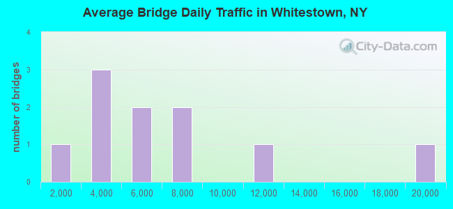
- 68,259Total average daily traffic
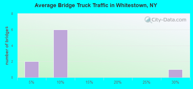
- 7,751Total average daily truck traffic
- National Bridge Inventory (NBI) Registered Bridges for Whitestown
- No street view available for this location
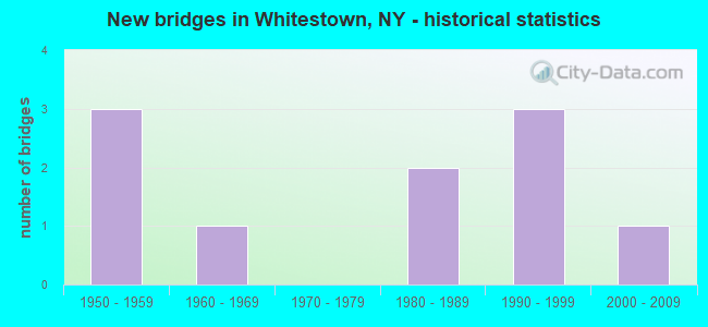
- New bridges - historical statistics
- 31950-1959
- 11960-1969
- 21980-1989
- 31990-1999
- 12000-2009
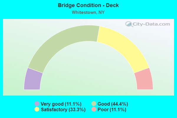
- Bridge Condition - Deck
- 11.1%Very good
- 44.4%Good
- 33.3%Satisfactory
- 11.1%Poor
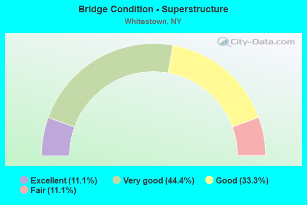
- Bridge Condition - Superstructure
- 11.1%Excellent
- 44.4%Very good
- 33.3%Good
- 11.1%Fair
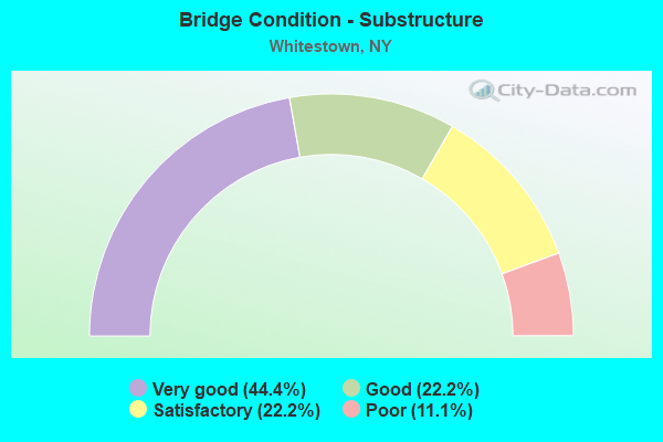
- Bridge Condition - Substructure
- 44.4%Very good
- 22.2%Good
- 22.2%Satisfactory
- 11.1%Poor
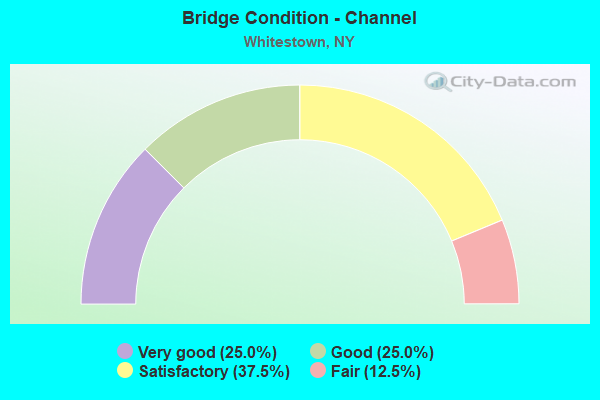
- Bridge Condition - Channel
- 25.0%Very good
- 25.0%Good
- 37.5%Satisfactory
- 12.5%Fair
Find on map >> Show street view
Structure Number: 105176, Location: .2 MI NE JCT RTS 69 & 291 (Lat: 43.139233, Lng: -75.303533), Route carried "on" structure: State highway 291, Year Built: 1994, Status: Open, Structure Length: 10.52m (34.51ft), Average Daily Traffic: 7,980 (year 2020), Truck Traffic: 7%, Average Future Daily Traffic: 9,694 (year 2040), Design Load: HS 25 or greater, Features Intersected: CSX TRANS/AMTRAK, MOHAWK
Minimum Vertical Clearance: 30+ m (98+ ft), Kilometerpoint: 0.129, Lanes on structure: 2, Base Highway Network: Yes, Owner: State Highway Agency, Approaching Roadway Width: 11.9m (39.0ft), Material/Design: Steel continuous, Design/Construction: Stringer/Multi-beam, Number Of Spans In Main Unit: 2, Length of Maximum Span: 54.8m (179.8ft), Curb-To-Curb Width: 12.0m (39.4ft), Out-to-Out Width: 13.0m (42.7ft)
Condition: Deck: Good, Superstructure: Very good, Substructure: Very good, Channel: Very good, Operating Rating: 89.8 metric tons, Method Used To Determine Operating Rating: Load Factor (LF), Inventory Rating: 57.2 metric tons, Method Used To Determine Inventory Rating: Load Factor (LF), Structural Evaluation: Equal to present desirable criteria, Deck Geometry: Somewhat better than minimum adequacy, Underclear: Superior to present desirable criteria, Waterway Adequacy: Equal to present minimum criteria, Approach Roadway Alignment: Equal to present desirable criteria, Length Of Structure Improvement: 10.51m (34.48ft), Designated Inspection Frequency: Every 24 months, Inspection Date: September 2020, Bridge Improvement Cost: $2,603,000, Roadway Improvement Cost: $1,524,000, Total Project Cost: $4,127,000 ( Estimate for 2021), Deck Structure Type: Concrete Cast-file-Place, Wearing Surface/Protective System: Wearing Surface: Integral Concrete, Deck Protection: Epoxy Coated Reinforcing
Find on map >> Show street view
Structure Number: 225564, Location: WHITESBORO (Lat: 43.117250, Lng: -75.284428), Route carried "on" structure: Other road , Year Built: 1986, Status: Open, Structure Length: 2.93m (9.61ft), Average Daily Traffic: 5,405 (year 2020), Truck Traffic: 3%, Average Future Daily Traffic: 6,687 (year 2040), Design Load: HS 20, Features Intersected: SAUQUOIT CREEK, Facility Carried by Structure: MAIN STREET
Minimum Vertical Clearance: 30+ m (98+ ft), Kilometerpoint: 2.767, Lanes on structure: 2, Owner: Town or Township Highway Agency, Approaching Roadway Width: 10.7m (35.1ft), Skew: 1 degrees, Material/Design: Prestressed concrete, Design/Construction: Box Beam or Girders - Multiple, Number Of Spans In Main Unit: 1, Length of Maximum Span: 27.7m (90.9ft), Curb or Sidewalk Widths: Left: 1.5m (4.9ft), Right: 1.5m (4.9ft), Curb-To-Curb Width: 10.7m (35.1ft), Out-to-Out Width: 14.4m (47.2ft)
Condition: Deck: Satisfactory, Superstructure: Good, Substructure: Good, Channel: Fair, Operating Rating: 51.7 metric tons, Method Used To Determine Operating Rating: Load Factor (LF), Inventory Rating: 22.7 metric tons, Method Used To Determine Inventory Rating: Load Factor (LF), Structural Evaluation: Somewhat better than minimum adequacy, Deck Geometry: Meets minimum limits, Waterway Adequacy: Meets minimum limits, Approach Roadway Alignment: Equal to present desirable criteria, Length Of Structure Improvement: 2.92m (9.58ft), Designated Inspection Frequency: Every 24 months, Inspection Date: June 2020, Bridge Improvement Cost: $1,004,000, Roadway Improvement Cost: $588,000, Total Project Cost: $1,592,000 ( Estimate for 2021), Deck Structure Type: Concrete Cast-file-Place, Wearing Surface/Protective System: Wearing Surface: Integral Concrete, Deck Protection: Epoxy Coated Reinforcing
Find on map >> Show street view
Structure Number: 331141, Location: 3/4 MI S OF ORISKANY (Lat: 43.142908, Lng: -75.337683), Route carried "on" structure: County highway , Year Built: 1986, Status: Open, Structure Length: 3.99m (13.09ft), Average Daily Traffic: 1,529 (year 2018), Truck Traffic: 3%, Average Future Daily Traffic: 1,891 (year 2040), Design Load: HS 20, Features Intersected: ORISKANY CREEK, Facility Carried by Structure: CR32 VALLEY ROAD
Minimum Vertical Clearance: 30+ m (98+ ft), Kilometerpoint: 0.998, Lanes on structure: 2, Owner: County Highway Agency, Approaching Roadway Width: 8.5m (27.9ft), Skew: 1 degrees, Material/Design: Steel, Design/Construction: Stringer/Multi-beam, Number Of Spans In Main Unit: 1, Length of Maximum Span: 38.1m (125.0ft), Curb-To-Curb Width: 8.5m (27.9ft), Out-to-Out Width: 9.1m (29.9ft)
Condition: Deck: Good, Superstructure: Very good, Substructure: Good, Channel: Satisfactory, Operating Rating: 99.8 metric tons, Method Used To Determine Operating Rating: Field evaluation and documented engineering judgment, Inventory Rating: 32.7 metric tons, Method Used To Determine Inventory Rating: Field evaluation and documented engineering judgment, Structural Evaluation: Better than present minimum criteria, Deck Geometry: Somewhat better than minimum adequacy, Waterway Adequacy: Somewhat better than minimum adequacy, Approach Roadway Alignment: Equal to present desirable criteria, Length Of Structure Improvement: 3.99m (13.09ft), Designated Inspection Frequency: Every 24 months, Inspection Date: July 2020, Bridge Improvement Cost: $690,000, Roadway Improvement Cost: $404,000, Total Project Cost: $1,093,000 ( Estimate for 2021), Deck Structure Type: Concrete Cast-file-Place, Wearing Surface/Protective System: Wearing Surface: Integral Concrete, Deck Protection: Epoxy Coated Reinforcing
Find on map >> Show street view
Structure Number: 331142, Location: 2 MI E ONEIDA CO. AIRPORT (Lat: 43.138081, Lng: -75.345094), Route carried "on" structure: County highway , Year Built: 1965, Status: Open, Structure Length: 6.98m (22.90ft), Average Daily Traffic: 4,967 (year 2020), Truck Traffic: 5%, Average Future Daily Traffic: 6,145 (year 2040), Design Load: HS 20, Features Intersected: ORISKANY CREEK, Facility Carried by Structure: CR840 JUDD ROAD
Minimum Vertical Clearance: 30+ m (98+ ft), Kilometerpoint: 3.218, Lanes on structure: 2, Owner: County Highway Agency, Approaching Roadway Width: 8.2m (26.9ft), Material/Design: Steel, Design/Construction: Stringer/Multi-beam, Number Of Spans In Main Unit: 2, Length of Maximum Span: 34.7m (113.8ft), Curb or Sidewalk Widths: Left: 0.6m (2.0ft), Right: 0.8m (2.6ft), Curb-To-Curb Width: 7.9m (25.9ft), Out-to-Out Width: 9.5m (31.2ft)
Condition: Deck: Satisfactory, Superstructure: Good, Substructure: Satisfactory, Channel: Very good, Operating Rating: 70.8 metric tons, Method Used To Determine Operating Rating: Load Factor (LF), Inventory Rating: 41.7 metric tons, Method Used To Determine Inventory Rating: Load Factor (LF), Structural Evaluation: Equal to present minimum criteria, Deck Geometry: High priority of corrective action, Waterway Adequacy: Equal to present minimum criteria, Approach Roadway Alignment: Better than present minimum criteria, Length Of Structure Improvement: 6.97m (22.87ft), Designated Inspection Frequency: Every 24 months, Inspection Date: August 2020, Bridge Improvement Cost: $1,092,000, Roadway Improvement Cost: $640,000, Total Project Cost: $1,732,000 ( Estimate for 2021), Deck Structure Type: Concrete Cast-file-Place, Wearing Surface/Protective System: Wearing Surface: Integral Concrete
Find on map >> Show street view
Structure Number: 331143, Location: 3.5 MI SE OF ORISKANY (Lat: 43.115639, Lng: -75.366058), Route carried "on" structure: County highway , Year Built: 1950, Year Reconstructed: 1993, Status: Open, Structure Length: 2.90m (9.51ft), Average Daily Traffic: 3,390 (year 2020), Truck Traffic: 8%, Average Future Daily Traffic: 4,194 (year 2040), Features Intersected: ORISKANY CREEK, Facility Carried by Structure: STONE ROAD
Minimum Vertical Clearance: 30+ m (98+ ft), Kilometerpoint: 3.105, Lanes on structure: 2, Owner: County Highway Agency, Approaching Roadway Width: 6.1m (20.0ft), Skew: 3 degrees, Material/Design: Steel, Design/Construction: Stringer/Multi-beam, Number Of Spans In Main Unit: 1, Length of Maximum Span: 26.8m (87.9ft), Curb-To-Curb Width: 7.6m (24.9ft), Out-to-Out Width: 8.2m (26.9ft)
Condition: Deck: Good, Superstructure: Good, Substructure: Satisfactory, Channel: Good, Operating Rating: 72.6 metric tons, Method Used To Determine Operating Rating: Load Factor (LF), Inventory Rating: 43.5 metric tons, Method Used To Determine Inventory Rating: Load Factor (LF), Structural Evaluation: Equal to present minimum criteria, Deck Geometry: High priority of replacement, Waterway Adequacy: Meets minimum limits, Approach Roadway Alignment: Equal to present minimum criteria, Length Of Structure Improvement: 2.89m (9.48ft), Designated Inspection Frequency: Every 24 months, Inspection Date: June 2021, Bridge Improvement Cost: $610,000, Roadway Improvement Cost: $357,000, Total Project Cost: $967,000 ( Estimate for 2021), Deck Structure Type: Concrete Cast-file-Place, Wearing Surface/Protective System: Wearing Surface: Bituminous, Deck Protection: Epoxy Coated Reinforcing
Find on map >> Show street view
Structure Number: 442603, Location: OVER BARGE C N ORISKANY (Lat: 43.168031, Lng: -75.323681), Route carried "on" structure: State highway 922, Year Built: 1991, Status: Open, Structure Length: 8.90m (29.20ft), Average Daily Traffic: 3,420 (year 2020), Truck Traffic: 7%, Average Future Daily Traffic: 4,231 (year 2040), Design Load: HS 20, Features Intersected: Erie Canal Trail, ERIE B
Minimum Vertical Clearance: 30+ m (98+ ft), Kilometerpoint: 1.175, Lanes on structure: 2, Base Highway Network: Yes, Owner: State Highway Agency, Approaching Roadway Width: 10.4m (34.1ft), Skew: 2 degrees, Navigation Control: Yes ( Vertical Clearance: 6.0m (19.7ft), Horizontal Clearance: 31.6m (103.7ft)), Material/Design: Steel continuous, Design/Construction: Stringer/Multi-beam, Number Of Spans In Main Unit: 3, Length of Maximum Span: 42.6m (139.8ft), Curb-To-Curb Width: 10.4m (34.1ft), Out-to-Out Width: 11.0m (36.1ft)
Condition: Deck: Good, Superstructure: Very good, Substructure: Very good, Channel: Good, Operating Rating: 87.1 metric tons, Method Used To Determine Operating Rating: Load Factor (LF), Inventory Rating: 44.5 metric tons, Method Used To Determine Inventory Rating: Load Factor (LF), Structural Evaluation: Equal to present desirable criteria, Deck Geometry: Somewhat better than minimum adequacy, Waterway Adequacy: Equal to present minimum criteria, Approach Roadway Alignment: Equal to present desirable criteria, Length Of Structure Improvement: 8.90m (29.20ft), Designated Inspection Frequency: Every 24 months, Underwater Inspection Frequency: Every 60 months, Inspection Date: September 2021, Underwater Inspection Date: August 2017, Bridge Improvement Cost: $1,542,000, Roadway Improvement Cost: $903,000, Total Project Cost: $2,446,000 ( Estimate for 2021), Deck Structure Type: Concrete Cast-file-Place, Wearing Surface/Protective System: Wearing Surface: Bituminous, Membrane: Other, Deck Protection: Epoxy Coated Reinforcing
Find on map >> Show street view
Structure Number: 44261, Location: 0.5MI N RTE69 IN ORISKANY (Lat: 43.165264, Lng: -75.325542), Route carried "on" structure: State highway 922, Year Built: 1991, Status: Open, Structure Length: 4.48m (14.70ft), Average Daily Traffic: 3,420 (year 2020), Truck Traffic: 7%, Average Future Daily Traffic: 4,231 (year 2040), Design Load: HS 20, Features Intersected: MOHAWK RIVER
Minimum Vertical Clearance: 30+ m (98+ ft), Kilometerpoint: 0.885, Lanes on structure: 2, Base Highway Network: Yes, Owner: State Highway Agency, Approaching Roadway Width: 10.4m (34.1ft), Skew: 1 degrees, Material/Design: Steel, Design/Construction: Stringer/Multi-beam, Number Of Spans In Main Unit: 1, Length of Maximum Span: 44.1m (144.7ft), Curb-To-Curb Width: 10.4m (34.1ft), Out-to-Out Width: 11.0m (36.1ft)
Condition: Deck: Very good, Superstructure: Excellent, Substructure: Very good, Channel: Satisfactory, Operating Rating: 78.0 metric tons, Method Used To Determine Operating Rating: Load Factor (LF), Inventory Rating: 34.5 metric tons, Method Used To Determine Inventory Rating: Load Factor (LF), Structural Evaluation: Equal to present desirable criteria, Deck Geometry: Somewhat better than minimum adequacy, Waterway Adequacy: Somewhat better than minimum adequacy, Approach Roadway Alignment: Equal to present desirable criteria, Length Of Structure Improvement: 4.48m (14.70ft), Designated Inspection Frequency: Every 24 months, Inspection Date: April 2021, Bridge Improvement Cost: $835,000, Roadway Improvement Cost: $489,000, Total Project Cost: $1,324,000 ( Estimate for 2021), Deck Structure Type: Concrete Cast-file-Place, Wearing Surface/Protective System: Wearing Surface: Bituminous, Membrane: Other, Deck Protection: Epoxy Coated Reinforcing
Find on map >> Show street view
Structure Number: 551298, Location: 7.63 MI W INT 31 ON I-90 (Lat: 43.127167, Lng: -75.344853), Route carried "on" structure: County highway , Year Built: 1952, Status: Open, Structure Length: 6.28m (20.60ft), Average Daily Traffic: 7,054 (year 2020), Truck Traffic: 6%, Average Future Daily Traffic: 8,727 (year 2040), Design Load: H 20, Features Intersected: 90IX EB, RTE I90, Facility Carried by Structure: JUDD ROAD
Minimum Vertical Clearance: 30+ m (98+ ft), Kilometerpoint: 2.011, Lanes on structure: 2, Lanes under structure: 4, Owner: State Toll Authority, Approaching Roadway Width: 7.6m (24.9ft), Skew: 1 degrees, Material/Design: Steel, Design/Construction: Stringer/Multi-beam, Number Of Spans In Main Unit: 4, Length of Maximum Span: 18.3m (60.0ft), Curb-To-Curb Width: 7.9m (25.9ft), Out-to-Out Width: 10.1m (33.1ft)
Condition: Deck: Poor, Superstructure: Fair, Substructure: Poor, Operating Rating: 63.5 metric tons, Method Used To Determine Operating Rating: Load Factor (LF), Inventory Rating: 38.1 metric tons, Method Used To Determine Inventory Rating: Load Factor (LF), Structural Evaluation: Meets minimum limits, Deck Geometry: High priority of corrective action, Underclear: High priority of corrective action, Approach Roadway Alignment: Equal to present minimum criteria, Length Of Structure Improvement: 6.27m (20.57ft), Designated Inspection Frequency: Every 24 months, Inspection Date: May 2021, Bridge Improvement Cost: $1,016,000, Roadway Improvement Cost: $595,000, Total Project Cost: $1,612,000 ( Estimate for 2021), Deck Structure Type: Concrete Cast-file-Place, Wearing Surface/Protective System: Wearing Surface: Monolithic Concrete
Find on map >> Show street view
Structure Number: 5513069, Location: 8 MI W EXIT 31 OF I90 (Lat: 43.127144, Lng: -75.351292), Route carried "on" structure: Interstate 90, Year Built: 2000, Status: Open, Structure Length: 6.46m (21.19ft), Average Daily Traffic: 19,195 (year 2020), Truck Traffic: 29%, Average Future Daily Traffic: 22,116 (year 2040), Design Load: HS 25 or greater, Features Intersected: ORISKANY CREEK
Minimum Vertical Clearance: 30+ m (98+ ft), Kilometerpoint: 25.068, Lanes on structure: 4, Base Highway Network: Yes, Toll: On Interstate toll segment, Owner: State Toll Authority, Approaching Roadway Width: 31.1m (102.0ft), Skew: 24 degrees, Material/Design: Steel continuous, Design/Construction: Stringer/Multi-beam, Number Of Spans In Main Unit: 2, Length of Maximum Span: 31.4m (103.0ft), Curb-To-Curb Width: 32.9m (107.9ft), Out-to-Out Width: 34.4m (112.9ft)
Condition: Deck: Satisfactory, Superstructure: Very good, Substructure: Very good, Channel: Satisfactory, Operating Rating: 72.6 metric tons, Method Used To Determine Operating Rating: Load Factor (LF), Inventory Rating: 43.5 metric tons, Method Used To Determine Inventory Rating: Load Factor (LF), Structural Evaluation: Equal to present desirable criteria, Deck Geometry: Superior to present desirable criteria, Waterway Adequacy: Superior to present desirable criteria, Approach Roadway Alignment: Equal to present desirable criteria, Length Of Structure Improvement: 6.46m (21.19ft), Designated Inspection Frequency: Every 24 months, Inspection Date: September 2020, Bridge Improvement Cost: $4,271,000, Roadway Improvement Cost: $2,501,000, Total Project Cost: $6,773,000 ( Estimate for 2021), Deck Structure Type: Concrete Cast-file-Place, Wearing Surface/Protective System: Wearing Surface: Integral Concrete, Deck Protection: Galvanized Reinforcing
Find on map >> Show street view
Structure Number: 551298, Location: 7.63 MI W INT 31 ON I-90 (Lat: 43.127167, Lng: -75.344853), Route carried "under" structure: Interstate 90, Year Built: 1952, Structure Length: 0. m, Average Daily Traffic: 11,899 (year 1977), Features Intersected: 90IX EB, RTE I90, Facility Carried by Structure: JUDD ROAD
Minimum Vertical Clearance: 4.90m (16.08ft), Kilometerpoint: 386.932, Lanes on structure: 2, Lanes under structure: 2, Toll: On Interstate toll segment, Material/Design: Steel, Design/Construction: Stringer/Multi-beam, Length of Maximum Span: 18.3m (60.0ft)