Bridge Statistics for Whitney Point, New York (NY)
Condition, Traffic, Stress, Structural Evaluation, Project Costs
- National Bridge Inventory (NBI) Statistics
- 24Number of bridges
- 344ft / 105mTotal length
- $56,400,000Total costs
- 158,876Total average daily traffic
- 23,287Total average daily truck traffic
- National Bridge Inventory (NBI) Registered Bridges for Whitney Point
- No street view available for this location
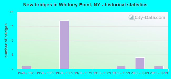
- New bridges - historical statistics
- 11940-1949
- 171960-1969
- 11990-1999
- 42000-2009
- 12010-2019

- Reconstructed bridges - Historical Statistics
- 11980-1989
- 01990-1999
- 42000-2009
- 22010-2019


- Bridge Condition - Deck
- 5.9%Very good
- 70.6%Good
- 17.6%Satisfactory
- 5.9%Fair

- Bridge Condition - Superstructure
- 5.9%Excellent
- 5.9%Very good
- 76.5%Good
- 5.9%Satisfactory
- 5.9%Fair

- Bridge Condition - Substructure
- 5.9%Excellent
- 17.6%Very good
- 64.7%Good
- 5.9%Satisfactory
- 5.9%Fair

- Bridge Condition - Channel
- 50.0%Very good
- 25.0%Good
- 12.5%Satisfactory
- 12.5%Fair
Find on map >> Show street view
Structure Number: 100832, Location: JCT US11 & TIOUGHNIOGA RV (Lat: 42.331008, Lng: -75.967778), Route carried "on" structure: US 11, Year Built: 1947, Year Reconstructed: 1993, Status: Open, Structure Length: 10.18m (33.40ft), Average Daily Traffic: 8,797 (year 2020), Truck Traffic: 11%, Average Future Daily Traffic: 8,880 (year 2040), Design Load: HS 20+Mod, Features Intersected: TIOUGHNIOGA RIVER
Minimum Vertical Clearance: 30+ m (98+ ft), Kilometerpoint: 49.348, Lanes on structure: 3, Base Highway Network: Yes, Owner: State Highway Agency, Approaching Roadway Width: 12.2m (40.0ft), Skew: 4 degrees, Material/Design: Steel, Design/Construction: Girder and Floorbeam System, Number Of Spans In Main Unit: 3, Length of Maximum Span: 33.5m (109.9ft), Curb or Sidewalk Widths: Left: 2.0m (6.6ft), Right: 2.0m (6.6ft), Curb-To-Curb Width: 12.3m (40.4ft), Out-to-Out Width: 17.6m (57.7ft)
Condition: Deck: Fair, Superstructure: Fair, Substructure: Fair, Channel: Good, Operating Rating: 41.7 metric tons, Method Used To Determine Operating Rating: Load Factor (LF), Inventory Rating: 25.4 metric tons, Method Used To Determine Inventory Rating: Load Factor (LF), Structural Evaluation: Somewhat better than minimum adequacy, Deck Geometry: Meets minimum limits, Waterway Adequacy: Somewhat better than minimum adequacy, Approach Roadway Alignment: Equal to present desirable criteria, Length Of Structure Improvement: 10.18m (33.40ft), Designated Inspection Frequency: Every 24 months, Critical Feature Inspection Frequency: Every 24 months, Inspection Date: September 2021, Critical Feature Inspection Date: September 2021, Bridge Improvement Cost: $5,191,000, Roadway Improvement Cost: $3,040,000, Total Project Cost: $8,230,000 ( Estimate for 2021), Deck Structure Type: Concrete Cast-file-Place, Wearing Surface/Protective System: Wearing Surface: Integral Concrete, Deck Protection: Epoxy Coated Reinforcing
Find on map >> Show street view
Structure Number: 101858, Location: JCT RTS 26 + I-81 (Lat: 42.320878, Lng: -75.971400), Route carried "on" structure: State highway 26, Year Built: 1965, Status: Open, Structure Length: 7.56m (24.80ft), Average Daily Traffic: 2,988 (year 2020), Truck Traffic: 8%, Average Future Daily Traffic: 3,016 (year 2040), Design Load: HS 20+Mod, Features Intersected: 81I 81I91013157, RTE I81
Minimum Vertical Clearance: 30+ m (98+ ft), Kilometerpoint: 44.183, Lanes on structure: 3, Lanes under structure: 4, Base Highway Network: Yes, Owner: State Highway Agency, Approaching Roadway Width: 14.3m (46.9ft), Material/Design: Steel, Design/Construction: Stringer/Multi-beam, Number Of Spans In Main Unit: 5, Length of Maximum Span: 16.1m (52.8ft), Curb or Sidewalk Widths: Left: 0.5m (1.6ft), Right: 0.5m (1.6ft), Curb-To-Curb Width: 11.6m (38.1ft), Out-to-Out Width: 13.2m (43.3ft)
Condition: Deck: Satisfactory, Superstructure: Good, Substructure: Good, Operating Rating: 50.8 metric tons, Method Used To Determine Operating Rating: Load Factor (LF), Inventory Rating: 29.9 metric tons, Method Used To Determine Inventory Rating: Load Factor (LF), Structural Evaluation: Better than present minimum criteria, Deck Geometry: High priority of replacement, Underclear: High priority of corrective action, Approach Roadway Alignment: Equal to present desirable criteria, Length Of Structure Improvement: 7.55m (24.77ft), Designated Inspection Frequency: Every 24 months, Inspection Date: June 2020, Bridge Improvement Cost: $2,207,000, Roadway Improvement Cost: $1,292,000, Total Project Cost: $3,499,000 ( Estimate for 2021), Deck Structure Type: Concrete Cast-file-Place, Wearing Surface/Protective System: Wearing Surface: Integral Concrete
Find on map >> Show street view
Structure Number: 101859, Location: .4 MI N JCT SH 26 & I81 (Lat: 42.325831, Lng: -75.967653), Route carried "on" structure: State highway 26, Year Built: 1965, Status: Open, Structure Length: 6.19m (20.31ft), Average Daily Traffic: 8,851 (year 2018), Truck Traffic: 8%, Average Future Daily Traffic: 8,935 (year 2040), Design Load: HS 20+Mod, Features Intersected: NY SUSQUEHNNA & WESTERN,
Minimum Vertical Clearance: 30+ m (98+ ft), Kilometerpoint: 44.795, Lanes on structure: 2, Base Highway Network: Yes, Owner: State Highway Agency, Approaching Roadway Width: 11.9m (39.0ft), Material/Design: Steel, Design/Construction: Stringer/Multi-beam, Number Of Spans In Main Unit: 4, Length of Maximum Span: 18.2m (59.7ft), Curb-To-Curb Width: 8.5m (27.9ft), Out-to-Out Width: 10.1m (33.1ft)
Condition: Deck: Good, Superstructure: Good, Substructure: Good, Channel: Very good, Operating Rating: 49.9 metric tons, Method Used To Determine Operating Rating: Load and Resistance Factor Rating (LRFR) rating reported by rating factor(RF) method using HL-93 loadings, Inventory Rating: 38.2 metric tons, Method Used To Determine Inventory Rating: Load and Resistance Factor Rating (LRFR) rating reported by rating factor(RF) method using HL-93 loadings, Structural Evaluation: Better than present minimum criteria, Deck Geometry: Meets minimum limits, Underclear: Better than present minimum criteria, Waterway Adequacy: Equal to present minimum criteria, Approach Roadway Alignment: Equal to present desirable criteria, Length Of Structure Improvement: 6.18m (20.28ft), Designated Inspection Frequency: Every 24 months, Inspection Date: August 2021, Bridge Improvement Cost: $1,366,000, Roadway Improvement Cost: $800,000, Total Project Cost: $2,165,000 ( Estimate for 2021), Deck Structure Type: Concrete Cast-file-Place, Wearing Surface/Protective System: Wearing Surface: Integral Concrete
Find on map >> Show street view
Structure Number: 10186, Location: JCT RTE 26+TIOUGHNIOGA R (Lat: 42.329194, Lng: -75.965100), Route carried "on" structure: State highway 26, Year Built: 2017, Status: Open, Structure Length: 8.14m (26.71ft), Average Daily Traffic: 6,617 (year 2020), Truck Traffic: 10%, Average Future Daily Traffic: 6,658 (year 2040), Design Load: HL 93, Features Intersected: TIOUGHNIOGA RIVER
Minimum Vertical Clearance: 30+ m (98+ ft), Kilometerpoint: 45.374, Lanes on structure: 3, Base Highway Network: Yes, Owner: State Highway Agency, Approaching Roadway Width: 13.5m (44.3ft), Skew: 2 degrees, Material/Design: Steel continuous, Design/Construction: Stringer/Multi-beam, Number Of Spans In Main Unit: 2, Length of Maximum Span: 45.7m (149.9ft), Curb or Sidewalk Widths: Left: 1.6m (5.2ft), Right: 1.6m (5.2ft), Curb-To-Curb Width: 13.5m (44.3ft), Out-to-Out Width: 17.6m (57.7ft)
Condition: Deck: Very good, Superstructure: Excellent, Substructure: Excellent, Channel: Very good, Operating Rating: 50.5 metric tons, Method Used To Determine Operating Rating: Load and Resistance Factor Rating (LRFR) rating reported by rating factor(RF) method using HL-93 loadings, Inventory Rating: 38.9 metric tons, Method Used To Determine Inventory Rating: Load and Resistance Factor Rating (LRFR) rating reported by rating factor(RF) method using HL-93 loadings, Structural Evaluation: Superior to present desirable criteria, Deck Geometry: Somewhat better than minimum adequacy, Waterway Adequacy: Equal to present minimum criteria, Approach Roadway Alignment: Meets minimum limits, Length Of Structure Improvement: 8.13m (26.67ft), Designated Inspection Frequency: Every 24 months, Inspection Date: August 2021, Bridge Improvement Cost: $3,982,000, Roadway Improvement Cost: $2,332,000, Total Project Cost: $6,313,000 ( Estimate for 2021), Deck Structure Type: Concrete Cast-file-Place, Wearing Surface/Protective System: Wearing Surface: Integral Concrete, Deck Protection: Epoxy Coated Reinforcing
Find on map >> Show street view
Structure Number: 10305, Location: 3.3 MI SE JCT 79 & 206 (Lat: 42.302122, Lng: -75.912842), Route carried "on" structure: State highway 79, Year Built: 2007, Status: Open, Structure Length: 1.13m (3.71ft), Average Daily Traffic: 1,233 (year 2020), Truck Traffic: 11%, Average Future Daily Traffic: 1,726 (year 2040), Design Load: HS 25 or greater, Features Intersected: BULL CREEK
Minimum Vertical Clearance: 30+ m (98+ ft), Kilometerpoint: 15.414, Lanes on structure: 2, Base Highway Network: Yes, Owner: State Highway Agency, Approaching Roadway Width: 10.1m (33.1ft), Skew: 1 degrees, Material/Design: Concrete, Design/Construction: Frame, Number Of Spans In Main Unit: 1, Length of Maximum Span: 10.4m (34.1ft), Curb-To-Curb Width: 10.2m (33.5ft), Out-to-Out Width: 11.6m (38.1ft)
Condition: Deck: Good, Superstructure: Good, Substructure: Very good, Channel: Fair, Operating Rating: 52.8 metric tons, Method Used To Determine Operating Rating: Load and Resistance Factor Rating (LRFR) rating reported by rating factor(RF) method using HL-93 loadings, Inventory Rating: 40.8 metric tons, Method Used To Determine Inventory Rating: Load and Resistance Factor Rating (LRFR) rating reported by rating factor(RF) method using HL-93 loadings, Structural Evaluation: Better than present minimum criteria, Deck Geometry: Somewhat better than minimum adequacy, Waterway Adequacy: Somewhat better than minimum adequacy, Approach Roadway Alignment: Equal to present desirable criteria, Length Of Structure Improvement: 1.12m (3.67ft), Designated Inspection Frequency: Every 24 months, Inspection Date: March 2021, Bridge Improvement Cost: $438,000, Roadway Improvement Cost: $257,000, Total Project Cost: $695,000 ( Estimate for 2021)
Find on map >> Show street view
Structure Number: 103051, Location: 0.6MI SE JCT RTS 79 + 206 (Lat: 42.324722, Lng: -75.954811), Route carried "on" structure: State highway 79, Year Built: 2007, Status: Open, Structure Length: 1.95m (6.40ft), Average Daily Traffic: 1,233 (year 2020), Truck Traffic: 11%, Average Future Daily Traffic: 1,726 (year 2040), Design Load: HL 93, Features Intersected: MOSS CREEK
Minimum Vertical Clearance: 30+ m (98+ ft), Kilometerpoint: 19.775, Lanes on structure: 2, Base Highway Network: Yes, Owner: State Highway Agency, Approaching Roadway Width: 10.1m (33.1ft), Material/Design: Prestressed concrete, Design/Construction: Box Beam or Girders - Multiple, Number Of Spans In Main Unit: 1, Length of Maximum Span: 18.4m (60.4ft), Curb-To-Curb Width: 10.4m (34.1ft), Out-to-Out Width: 11.5m (37.7ft)
Condition: Deck: Good, Superstructure: Good, Substructure: Very good, Channel: Satisfactory, Operating Rating: 97.2 metric tons, Method Used To Determine Operating Rating: Load and Resistance Factor Rating (LRFR) rating reported by rating factor(RF) method using HL-93 loadings, Inventory Rating: 81.3 metric tons, Method Used To Determine Inventory Rating: Load and Resistance Factor Rating (LRFR) rating reported by rating factor(RF) method using HL-93 loadings, Structural Evaluation: Better than present minimum criteria, Deck Geometry: Equal to present minimum criteria, Waterway Adequacy: Somewhat better than minimum adequacy, Approach Roadway Alignment: Equal to present desirable criteria, Length Of Structure Improvement: 1.95m (6.40ft), Designated Inspection Frequency: Every 24 months, Inspection Date: March 2021, Bridge Improvement Cost: $538,000, Roadway Improvement Cost: $315,000, Total Project Cost: $852,000 ( Estimate for 2021), Wearing Surface/Protective System: Wearing Surface: Monolithic Concrete
Find on map >> Show street view
Structure Number: 103123, Location: 2.5 MI N EXIT 7 OF I81 (Lat: 42.286931, Lng: -75.924642), Route carried "on" structure: Other road , Year Built: 1969, Year Reconstructed: 2017, Status: Open, Structure Length: 4.36m (14.30ft), Average Daily Traffic: 176 (year 2019), Truck Traffic: 8%, Average Future Daily Traffic: 246 (year 2039), Design Load: HS 20+Mod, Features Intersected: RTE I81, Facility Carried by Structure: JOYNER ROAD
Minimum Vertical Clearance: 30+ m (98+ ft), Kilometerpoint: 2.269, Lanes on structure: 2, Lanes under structure: 2, Owner: State Highway Agency, Approaching Roadway Width: 7.3m (24.0ft), Skew: 2 degrees, Material/Design: Steel, Design/Construction: Stringer/Multi-beam, Number Of Spans In Main Unit: 3, Length of Maximum Span: 16.7m (54.8ft), Curb or Sidewalk Widths: Left: 0.5m (1.6ft), Right: 0.5m (1.6ft), Curb-To-Curb Width: 8.5m (27.9ft), Out-to-Out Width: 10.0m (32.8ft)
Condition: Deck: Good, Superstructure: Good, Substructure: Good, Operating Rating: 56.2 metric tons, Method Used To Determine Operating Rating: Load Factor (LF), Inventory Rating: 33.6 metric tons, Method Used To Determine Inventory Rating: Load Factor (LF), Structural Evaluation: Better than present minimum criteria, Deck Geometry: Equal to present minimum criteria, Underclear: High priority of corrective action, Approach Roadway Alignment: Equal to present desirable criteria, Length Of Structure Improvement: 4.35m (14.27ft), Designated Inspection Frequency: Every 24 months, Inspection Date: June 2021, Bridge Improvement Cost: $1,017,000, Roadway Improvement Cost: $595,000, Total Project Cost: $1,612,000 ( Estimate for 2021), Deck Structure Type: Concrete Cast-file-Place, Wearing Surface/Protective System: Wearing Surface: Integral Concrete
Find on map >> Show street view
Structure Number: 1031241, Location: 1.0MI S JCT RTS I-81 + 26 (Lat: 42.313858, Lng: -75.954472), Route carried "on" structure: Interstate 81, Year Built: 1969, Status: Open, Structure Length: 4.66m (15.29ft), Average Daily Traffic: 12,949 (year 2013), Truck Traffic: 21%, Average Future Daily Traffic: 18,128 (year 2033), Design Load: HS 20+Mod, Features Intersected: PEASE HILL ROAD
Minimum Vertical Clearance: 30+ m (98+ ft), Kilometerpoint: 45.052, Lanes on structure: 2, Lanes under structure: 2, Base Highway Network: Yes, Owner: State Highway Agency, Approaching Roadway Width: 11.0m (36.1ft), Skew: 2 degrees, Material/Design: Steel, Design/Construction: Stringer/Multi-beam, Number Of Spans In Main Unit: 3, Length of Maximum Span: 15.5m (50.9ft), Curb or Sidewalk Widths: Left: 0.6m (2.0ft), Right: 0.6m (2.0ft), Curb-To-Curb Width: 10.9m (35.8ft), Out-to-Out Width: 12.6m (41.3ft)
Condition: Deck: Good, Superstructure: Good, Substructure: Good, Operating Rating: 79.8 metric tons, Method Used To Determine Operating Rating: Load Factor (LF), Inventory Rating: 48.1 metric tons, Method Used To Determine Inventory Rating: Load Factor (LF), Structural Evaluation: Better than present minimum criteria, Deck Geometry: Meets minimum limits, Underclear: Somewhat better than minimum adequacy, Approach Roadway Alignment: Equal to present desirable criteria, Length Of Structure Improvement: 4.66m (15.29ft), Designated Inspection Frequency: Every 24 months, Inspection Date: June 2020, Bridge Improvement Cost: $1,294,000, Roadway Improvement Cost: $758,000, Total Project Cost: $2,052,000 ( Estimate for 2021), Deck Structure Type: Concrete Cast-file-Place, Wearing Surface/Protective System: Wearing Surface: Monolithic Concrete
Find on map >> Show street view
Structure Number: 1031242, Location: 1.0MI S JCT RTS I-81 + 26 (Lat: 42.314008, Lng: -75.954167), Route carried "on" structure: Interstate 81, Year Built: 1969, Status: Open, Structure Length: 4.66m (15.29ft), Average Daily Traffic: 10,676 (year 2020), Truck Traffic: 26%, Average Future Daily Traffic: 12,715 (year 2040), Design Load: HS 20+Mod, Features Intersected: PEASE HILL ROAD
Minimum Vertical Clearance: 30+ m (98+ ft), Kilometerpoint: 45.052, Lanes on structure: 2, Lanes under structure: 2, Base Highway Network: Yes, Owner: State Highway Agency, Approaching Roadway Width: 11.0m (36.1ft), Skew: 2 degrees, Material/Design: Steel, Design/Construction: Stringer/Multi-beam, Number Of Spans In Main Unit: 3, Length of Maximum Span: 15.5m (50.9ft), Curb or Sidewalk Widths: Left: 0.6m (2.0ft), Right: 0.6m (2.0ft), Curb-To-Curb Width: 10.9m (35.8ft), Out-to-Out Width: 12.6m (41.3ft)
Condition: Deck: Good, Superstructure: Good, Substructure: Good, Operating Rating: 79.8 metric tons, Method Used To Determine Operating Rating: Load Factor (LF), Inventory Rating: 48.1 metric tons, Method Used To Determine Inventory Rating: Load Factor (LF), Structural Evaluation: Better than present minimum criteria, Deck Geometry: Meets minimum limits, Underclear: Equal to present minimum criteria, Approach Roadway Alignment: Equal to present desirable criteria, Length Of Structure Improvement: 4.66m (15.29ft), Designated Inspection Frequency: Every 24 months, Inspection Date: June 2020, Bridge Improvement Cost: $1,294,000, Roadway Improvement Cost: $758,000, Total Project Cost: $2,052,000 ( Estimate for 2021), Deck Structure Type: Concrete Cast-file-Place, Wearing Surface/Protective System: Wearing Surface: Monolithic Concrete
Find on map >> Show street view
Structure Number: 1031261, Location: 0.9MI N JCT RTS I-81 + 26 (Lat: 42.333728, Lng: -75.978978), Route carried "on" structure: Interstate 81, Year Built: 1969, Year Reconstructed: 2008, Status: Open, Structure Length: 6.46m (21.19ft), Average Daily Traffic: 8,018 (year 2009), Truck Traffic: 36%, Average Future Daily Traffic: 11,225 (year 2029), Design Load: HS 20+Mod, Features Intersected: NY SUSQ & WESTERN RR
Minimum Vertical Clearance: 30+ m (98+ ft), Kilometerpoint: 48.367, Lanes on structure: 2, Base Highway Network: Yes, Owner: State Highway Agency, Approaching Roadway Width: 12.2m (40.0ft), Skew: 4 degrees, Material/Design: Steel, Design/Construction: Stringer/Multi-beam, Number Of Spans In Main Unit: 3, Length of Maximum Span: 21.6m (70.9ft), Curb-To-Curb Width: 11.9m (39.0ft), Out-to-Out Width: 12.8m (42.0ft)
Condition: Deck: Good, Superstructure: Good, Substructure: Good, Operating Rating: 93.4 metric tons, Method Used To Determine Operating Rating: Load Factor (LF), Inventory Rating: 55.3 metric tons, Method Used To Determine Inventory Rating: Load Factor (LF), Structural Evaluation: Better than present minimum criteria, Deck Geometry: Equal to present minimum criteria, Underclear: Equal to present minimum criteria, Approach Roadway Alignment: Equal to present desirable criteria, Length Of Structure Improvement: 6.46m (21.19ft), Designated Inspection Frequency: Every 24 months, Inspection Date: July 2020, Bridge Improvement Cost: $1,857,000, Roadway Improvement Cost: $1,087,000, Total Project Cost: $2,944,000 ( Estimate for 2021), Deck Structure Type: Concrete Cast-file-Place, Wearing Surface/Protective System: Wearing Surface: Integral Concrete
Find on map >> Show street view
Structure Number: 1031262, Location: 0.9MI N JCT RTS I-81 + 26 (Lat: 42.333572, Lng: -75.978769), Route carried "on" structure: Interstate 81, Year Built: 1969, Year Reconstructed: 2008, Status: Open, Structure Length: 6.46m (21.19ft), Average Daily Traffic: 6,935 (year 2019), Truck Traffic: 30%, Average Future Daily Traffic: 8,259 (year 2040), Design Load: HS 20+Mod, Features Intersected: NY SUSQ & WESTERN RR
Minimum Vertical Clearance: 30+ m (98+ ft), Kilometerpoint: 48.367, Lanes on structure: 2, Base Highway Network: Yes, Owner: State Highway Agency, Approaching Roadway Width: 12.2m (40.0ft), Skew: 4 degrees, Material/Design: Steel, Design/Construction: Stringer/Multi-beam, Number Of Spans In Main Unit: 3, Length of Maximum Span: 21.6m (70.9ft), Curb-To-Curb Width: 11.9m (39.0ft), Out-to-Out Width: 12.8m (42.0ft)
Condition: Deck: Good, Superstructure: Good, Substructure: Good, Inventory Rating: 61.7 metric tons, Method Used To Determine Inventory Rating: Load Factor (LF), Structural Evaluation: Better than present minimum criteria, Deck Geometry: Equal to present minimum criteria, Underclear: Equal to present minimum criteria, Approach Roadway Alignment: Equal to present desirable criteria, Length Of Structure Improvement: 6.46m (21.19ft), Designated Inspection Frequency: Every 24 months, Inspection Date: July 2020, Bridge Improvement Cost: $1,861,000, Roadway Improvement Cost: $1,090,000, Total Project Cost: $2,951,000 ( Estimate for 2021), Deck Structure Type: Concrete Cast-file-Place, Wearing Surface/Protective System: Wearing Surface: Integral Concrete
Find on map >> Show street view
Structure Number: 1031271, Location: JCT I-81 + TIOUGHNIOGA R (Lat: 42.336589, Lng: -75.978725), Route carried "on" structure: Interstate 81, Year Built: 2008, Status: Open, Structure Length: 11.13m (36.52ft), Average Daily Traffic: 8,018 (year 2009), Truck Traffic: 36%, Average Future Daily Traffic: 11,225 (year 2029), Design Load: HL 93, Features Intersected: TIOUGHNIOGA RIVER
Minimum Vertical Clearance: 30+ m (98+ ft), Kilometerpoint: 48.608, Lanes on structure: 2, Base Highway Network: Yes, Owner: State Highway Agency, Approaching Roadway Width: 11.9m (39.0ft), Skew: 4 degrees, Material/Design: Steel continuous, Design/Construction: Stringer/Multi-beam, Number Of Spans In Main Unit: 2, Length of Maximum Span: 54.4m (178.5ft), Curb-To-Curb Width: 12.0m (39.4ft), Out-to-Out Width: 12.9m (42.3ft)
Condition: Deck: Satisfactory, Superstructure: Good, Substructure: Good, Channel: Very good, Operating Rating: 78.0 metric tons, Method Used To Determine Operating Rating: Load Factor (LF), Inventory Rating: 46.3 metric tons, Method Used To Determine Inventory Rating: Load Factor (LF), Structural Evaluation: Better than present minimum criteria, Deck Geometry: Equal to present minimum criteria, Waterway Adequacy: Equal to present minimum criteria, Approach Roadway Alignment: Equal to present desirable criteria, Length Of Structure Improvement: 11.12m (36.48ft), Designated Inspection Frequency: Every 24 months, Inspection Date: August 2020, Bridge Improvement Cost: $4,125,000, Roadway Improvement Cost: $2,415,000, Total Project Cost: $6,540,000 ( Estimate for 2021), Deck Structure Type: Concrete Cast-file-Place, Wearing Surface/Protective System: Wearing Surface: Integral Concrete, Deck Protection: Epoxy Coated Reinforcing
Find on map >> Show street view
Structure Number: 1031272, Location: JCT I-81 + TIOUGHNIOGA R (Lat: 42.335772, Lng: -75.978572), Route carried "on" structure: Interstate 81, Year Built: 2009, Status: Open, Structure Length: 11.13m (36.52ft), Average Daily Traffic: 6,935 (year 2019), Truck Traffic: 30%, Average Future Daily Traffic: 8,259 (year 2040), Design Load: HL 93, Features Intersected: TIOUGHNIOGA RIVER
Minimum Vertical Clearance: 30+ m (98+ ft), Kilometerpoint: 48.640, Lanes on structure: 2, Base Highway Network: Yes, Owner: State Highway Agency, Approaching Roadway Width: 11.9m (39.0ft), Skew: 4 degrees, Material/Design: Steel continuous, Design/Construction: Stringer/Multi-beam, Number Of Spans In Main Unit: 2, Length of Maximum Span: 54.3m (178.1ft), Curb-To-Curb Width: 12.0m (39.4ft), Out-to-Out Width: 12.9m (42.3ft)
Condition: Deck: Good, Superstructure: Very good, Substructure: Very good, Channel: Very good, Operating Rating: 71.7 metric tons, Method Used To Determine Operating Rating: Load Factor (LF), Inventory Rating: 42.6 metric tons, Method Used To Determine Inventory Rating: Load Factor (LF), Structural Evaluation: Equal to present desirable criteria, Deck Geometry: Equal to present minimum criteria, Waterway Adequacy: Equal to present minimum criteria, Approach Roadway Alignment: Equal to present desirable criteria, Length Of Structure Improvement: 11.12m (36.48ft), Designated Inspection Frequency: Every 24 months, Inspection Date: August 2020, Bridge Improvement Cost: $4,101,000, Roadway Improvement Cost: $2,402,000, Total Project Cost: $6,503,000 ( Estimate for 2021), Deck Structure Type: Concrete Cast-file-Place, Wearing Surface/Protective System: Wearing Surface: Integral Concrete, Deck Protection: Epoxy Coated Reinforcing
Find on map >> Show street view
Structure Number: 1060751, Location: 0.7MI N JCT RTS I-81 + 26 (Lat: 42.331194, Lng: -75.979206), Route carried "on" structure: Interstate 81, Year Built: 1969, Year Reconstructed: 2008, Status: Open, Structure Length: 4.39m (14.40ft), Average Daily Traffic: 8,018 (year 2009), Truck Traffic: 36%, Average Future Daily Traffic: 11,225 (year 2029), Design Load: HS 20+Mod, Features Intersected: OLD ROUTE 26
Minimum Vertical Clearance: 30+ m (98+ ft), Kilometerpoint: 48.093, Lanes on structure: 2, Lanes under structure: 2, Base Highway Network: Yes, Owner: State Highway Agency, Approaching Roadway Width: 11.9m (39.0ft), Skew: 2 degrees, Material/Design: Steel, Design/Construction: Stringer/Multi-beam, Number Of Spans In Main Unit: 3, Length of Maximum Span: 14.6m (47.9ft), Curb-To-Curb Width: 11.4m (37.4ft), Out-to-Out Width: 12.6m (41.3ft)
Condition: Deck: Good, Superstructure: Good, Substructure: Good, Operating Rating: 85.3 metric tons, Method Used To Determine Operating Rating: Load Factor (LF), Inventory Rating: 50.8 metric tons, Method Used To Determine Inventory Rating: Load Factor (LF), Structural Evaluation: Better than present minimum criteria, Deck Geometry: Somewhat better than minimum adequacy, Underclear: Meets minimum limits, Approach Roadway Alignment: Equal to present desirable criteria, Length Of Structure Improvement: 4.38m (14.37ft), Designated Inspection Frequency: Every 24 months, Inspection Date: September 2020, Bridge Improvement Cost: $1,255,000, Roadway Improvement Cost: $735,000, Total Project Cost: $1,990,000 ( Estimate for 2021), Deck Structure Type: Concrete Cast-file-Place, Wearing Surface/Protective System: Wearing Surface: Monolithic Concrete
Find on map >> Show street view
Structure Number: 1060752, Location: 0.7MI N JCT RTS I-81 + 26 (Lat: 42.331092, Lng: -75.978992), Route carried "on" structure: Interstate 81, Year Built: 1969, Year Reconstructed: 2008, Status: Open, Structure Length: 4.72m (15.49ft), Average Daily Traffic: 6,935 (year 2019), Truck Traffic: 30%, Average Future Daily Traffic: 8,259 (year 2040), Design Load: HS 20+Mod, Features Intersected: OLD ROUTE 26
Minimum Vertical Clearance: 30+ m (98+ ft), Kilometerpoint: 48.093, Lanes on structure: 2, Lanes under structure: 2, Base Highway Network: Yes, Owner: State Highway Agency, Approaching Roadway Width: 11.3m (37.1ft), Skew: 2 degrees, Material/Design: Steel, Design/Construction: Stringer/Multi-beam, Number Of Spans In Main Unit: 3, Length of Maximum Span: 16.4m (53.8ft), Curb-To-Curb Width: 11.4m (37.4ft), Out-to-Out Width: 12.8m (42.0ft)
Condition: Deck: Good, Superstructure: Good, Substructure: Good, Operating Rating: 75.3 metric tons, Method Used To Determine Operating Rating: Load Factor (LF), Inventory Rating: 44.5 metric tons, Method Used To Determine Inventory Rating: Load Factor (LF), Structural Evaluation: Better than present minimum criteria, Deck Geometry: Somewhat better than minimum adequacy, Underclear: Meets minimum limits, Approach Roadway Alignment: Equal to present desirable criteria, Length Of Structure Improvement: 4.72m (15.49ft), Designated Inspection Frequency: Every 24 months, Inspection Date: September 2020, Bridge Improvement Cost: $1,369,000, Roadway Improvement Cost: $802,000, Total Project Cost: $2,171,000 ( Estimate for 2021), Deck Structure Type: Concrete Cast-file-Place, Wearing Surface/Protective System: Wearing Surface: Monolithic Concrete
Find on map >> Show street view
Structure Number: 109407, Location: 2.5 MI N EXIT 7 OF I81 (Lat: 42.286878, Lng: -75.925981), Route carried "on" structure: Other road , Year Built: 1969, Year Reconstructed: 2017, Status: Open, Structure Length: 4.45m (14.60ft), Average Daily Traffic: 176 (year 2019), Truck Traffic: 8%, Average Future Daily Traffic: 246 (year 2039), Design Load: HS 20+Mod, Features Intersected: RTE I81, Facility Carried by Structure: JOYNER ROAD
Minimum Vertical Clearance: 30+ m (98+ ft), Kilometerpoint: 2.381, Lanes on structure: 2, Lanes under structure: 2, Owner: State Highway Agency, Approaching Roadway Width: 7.3m (24.0ft), Skew: 1 degrees, Material/Design: Steel, Design/Construction: Stringer/Multi-beam, Number Of Spans In Main Unit: 3, Length of Maximum Span: 17.3m (56.8ft), Curb or Sidewalk Widths: Left: 0.5m (1.6ft), Right: 0.5m (1.6ft), Curb-To-Curb Width: 8.5m (27.9ft), Out-to-Out Width: 10.0m (32.8ft)
Condition: Deck: Good, Superstructure: Good, Substructure: Good, Operating Rating: 59.9 metric tons, Method Used To Determine Operating Rating: Load Factor (LF), Inventory Rating: 35.4 metric tons, Method Used To Determine Inventory Rating: Load Factor (LF), Structural Evaluation: Better than present minimum criteria, Deck Geometry: Equal to present minimum criteria, Underclear: High priority of corrective action, Approach Roadway Alignment: Equal to present desirable criteria, Length Of Structure Improvement: 4.45m (14.60ft), Designated Inspection Frequency: Every 24 months, Inspection Date: May 2021, Bridge Improvement Cost: $1,019,000, Roadway Improvement Cost: $597,000, Total Project Cost: $1,616,000 ( Estimate for 2021), Deck Structure Type: Concrete Cast-file-Place, Wearing Surface/Protective System: Wearing Surface: Integral Concrete
Find on map >> Show street view
Structure Number: 222531, Location: HAMLET OF ITASKA (Lat: 42.298697, Lng: -75.908300), Route carried "on" structure: Other road , Year Built: 1998, Status: Open, Structure Length: 7.65m (25.10ft), Average Daily Traffic: 449 (year 2019), Truck Traffic: 5%, Average Future Daily Traffic: 629 (year 2039), Design Load: HS 25 or greater, Features Intersected: TIOUGHNIOGA RIVER, Facility Carried by Structure: BARKER HILL ROAD
Minimum Vertical Clearance: 30+ m (98+ ft), Kilometerpoint: 1.432, Lanes on structure: 1, Owner: Town or Township Highway Agency, Approaching Roadway Width: 4.3m (14.1ft), Material/Design: Steel, Design/Construction: Truss - Thru, Number Of Spans In Main Unit: 2, Length of Maximum Span: 38.1m (125.0ft), Curb-To-Curb Width: 4.3m (14.1ft), Out-to-Out Width: 5.3m (17.4ft)
Condition: Deck: Satisfactory, Superstructure: Satisfactory, Substructure: Satisfactory, Channel: Good, Operating Rating: 40.8 metric tons, Method Used To Determine Operating Rating: Allowable Stress (AS), Inventory Rating: 28.1 metric tons, Method Used To Determine Inventory Rating: Allowable Stress (AS), Structural Evaluation: Equal to present minimum criteria, Deck Geometry: High priority of replacement, Waterway Adequacy: Somewhat better than minimum adequacy, Approach Roadway Alignment: High priority of corrective action, Length Of Structure Improvement: 7.65m (25.10ft), Designated Inspection Frequency: Every 24 months, Critical Feature Inspection Frequency: Every 24 months, Inspection Date: August 2020, Critical Feature Inspection Date: August 2020, Bridge Improvement Cost: $2,658,000, Roadway Improvement Cost: $1,557,000, Total Project Cost: $4,215,000 ( Estimate for 2021), Deck Structure Type: Corrugated Steel, Wearing Surface/Protective System: Wearing Surface: Bituminous
Find on map >> Show street view
Structure Number: 101858, Location: JCT RTS 26 + I-81 (Lat: 42.320878, Lng: -75.971400), Route carried "under" structure: Interstate 81, Year Built: 1965, Structure Length: 0. m, Average Daily Traffic: 12,600 (year 1972), Features Intersected: 81I 81I91013157, RTE I81, Facility Carried by Structure: RTE 26
Minimum Vertical Clearance: 5.21m (17.09ft), Kilometerpoint: 120.675, Lanes on structure: 3, Lanes under structure: 2, Material/Design: Steel, Design/Construction: Stringer/Multi-beam, Length of Maximum Span: 16.1m (52.8ft)
Find on map >> Show street view
Structure Number: 103123, Location: 2.5 MI N EXIT 7 OF I81 (Lat: 42.286931, Lng: -75.924642), Route carried "under" structure: Interstate 81, Year Built: 1969, Structure Length: 0. m, Average Daily Traffic: 23,636 (year 2000), Features Intersected: RTE I81, Facility Carried by Structure: JOYNER ROAD
Minimum Vertical Clearance: 5.56m (18.24ft), Kilometerpoint: 19.437, Lanes on structure: 2, Lanes under structure: 2, Material/Design: Steel, Design/Construction: Stringer/Multi-beam, Length of Maximum Span: 16.7m (54.8ft)
Find on map >> Show street view
Structure Number: 1031241, Location: 1.0MI S JCT RTS I-81 + 26 (Lat: 42.313858, Lng: -75.954472), Route carried "under" structure: Other road , Year Built: 1969, Structure Length: 0. m, Features Intersected: PEASE HILL ROAD, Facility Carried by Structure: RTE I81
Minimum Vertical Clearance: 4.39m (14.40ft), Kilometerpoint: 1.818, Lanes on structure: 2, Lanes under structure: 2, Material/Design: Steel, Design/Construction: Stringer/Multi-beam, Length of Maximum Span: 15.5m (50.9ft)
Find on map >> Show street view
Structure Number: 1031242, Location: 1.0MI S JCT RTS I-81 + 26 (Lat: 42.314008, Lng: -75.954167), Route carried "under" structure: Other road , Year Built: 1969, Structure Length: 0. m, Features Intersected: PEASE HILL ROAD, Facility Carried by Structure: RTE I81
Minimum Vertical Clearance: 4.60m (15.09ft), Kilometerpoint: 3.234, Lanes on structure: 2, Lanes under structure: 2, Material/Design: Steel, Design/Construction: Stringer/Multi-beam, Length of Maximum Span: 15.5m (50.9ft)
Find on map >> Show street view
Structure Number: 1060751, Location: 0.7MI N JCT RTS I-81 + 26 (Lat: 42.331194, Lng: -75.979206), Route carried "under" structure: Bypass County highway , Year Built: 1969, Structure Length: 0. m, Features Intersected: OLD ROUTE 26, Facility Carried by Structure: RTE I81
Minimum Vertical Clearance: 4.42m (14.50ft), Kilometerpoint: 0.064, Lanes on structure: 2, Lanes under structure: 2, Material/Design: Steel, Design/Construction: Stringer/Multi-beam, Length of Maximum Span: 14.6m (47.9ft)
Find on map >> Show street view
Structure Number: 1060752, Location: 0.7MI N JCT RTS I-81 + 26 (Lat: 42.331092, Lng: -75.978992), Route carried "under" structure: Bypass County highway , Year Built: 1969, Structure Length: 0. m, Features Intersected: OLD ROUTE 26, Facility Carried by Structure: RTE I81
Minimum Vertical Clearance: 5.13m (16.83ft), Kilometerpoint: 0.402, Lanes on structure: 2, Lanes under structure: 2, Material/Design: Steel, Design/Construction: Stringer/Multi-beam, Length of Maximum Span: 16.4m (53.8ft)
Find on map >> Show street view
Structure Number: 109407, Location: 2.5 MI N EXIT 7 OF I81 (Lat: 42.286878, Lng: -75.925981), Route carried "under" structure: Interstate 81, Year Built: 1969, Structure Length: 0. m, Average Daily Traffic: 23,636 (year 2000), Features Intersected: RTE I81, Facility Carried by Structure: JOYNER ROAD
Minimum Vertical Clearance: 5.03m (16.50ft), Kilometerpoint: 19.308, Lanes on structure: 2, Lanes under structure: 2, Material/Design: Steel, Design/Construction: Stringer/Multi-beam, Length of Maximum Span: 17.3m (56.8ft)