Bridge Statistics for Williamsburg, Iowa (IA)
Condition, Traffic, Stress, Structural Evaluation, Project Costs
- National Bridge Inventory (NBI) Statistics
- 31Number of bridges
- 177ft / 54.5mTotal length
- 143,455Total average daily traffic
- 39,261Total average daily truck traffic
- National Bridge Inventory (NBI) Registered Bridges for Williamsburg
- No street view available for this location
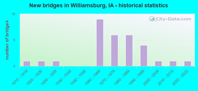
- New bridges - historical statistics
- 11910-1919
- 11920-1929
- 11930-1939
- 91960-1969
- 61970-1979
- 61980-1989
- 41990-1999
- 12000-2009
- 12010-2019
- 12020-2022


- Bridge Condition - Deck
- 5.9%Excellent
- 5.9%Very good
- 29.4%Good
- 23.5%Satisfactory
- 11.8%Fair
- 23.5%Poor

- Bridge Condition - Superstructure
- 5.9%Excellent
- 5.9%Very good
- 35.3%Good
- 29.4%Satisfactory
- 17.6%Fair
- 5.9%Poor

- Bridge Condition - Substructure
- 5.9%Excellent
- 23.5%Very good
- 17.6%Good
- 5.9%Satisfactory
- 23.5%Fair
- 17.6%Poor
- 5.9%Serious

- Bridge Condition - Channel
- 12.0%Very good
- 28.0%Good
- 48.0%Satisfactory
- 12.0%Fair

- Bridge Condition - Culverts
- 10.0%Very good
- 20.0%Good
- 70.0%Satisfactory
Find on map >> Show street view
Structure Number: 29481, Location: 1.9 mi. S of Jct. SR F46 (Lat: 41.633394, Lng: -92.007267), Route carried "on" structure: State highway 149, Year Built: 1985, Status: Open, Structure Length: 0.98m (3.22ft), Average Daily Traffic: 1,990 (year 2020), Truck Traffic: 8%, Average Future Daily Traffic: 1,990 (year 2041), Design Load: HS 20, Features Intersected: BRANCH OLD MANS CREEK
Minimum Vertical Clearance: 30+ m (98+ ft), Kilometerpoint: 99.902, Lanes on structure: 2, Base Highway Network: Yes, Owner: State Highway Agency, Approaching Roadway Width: 13.4m (44.0ft), Material/Design: Concrete continuous, Design/Construction: Culvert, Number Of Spans In Main Unit: 3, Length of Maximum Span: 3.0m (9.8ft)
Condition: Channel: Satisfactory, Culverts: Satisfactory, Operating Rating: 57.6 metric tons, Method Used To Determine Operating Rating: Load Factor (LF), Inventory Rating: 34.5 metric tons, Method Used To Determine Inventory Rating: Load Factor (LF), Structural Evaluation: Equal to present minimum criteria, Waterway Adequacy: Equal to present minimum criteria, Approach Roadway Alignment: Better than present minimum criteria, Designated Inspection Frequency: Every 24 months, Inspection Date: December 2021
Find on map >> Show street view
Structure Number: 29491, Location: 0.9 mi. S of Jct. SR F46 (Lat: 41.648469, Lng: -92.007400), Route carried "on" structure: State highway 149, Year Built: 1985, Status: Open, Structure Length: 0.98m (3.22ft), Average Daily Traffic: 1,990 (year 2020), Truck Traffic: 8%, Average Future Daily Traffic: 1,990 (year 2041), Design Load: HS 20, Features Intersected: BRANCH OLD MANS CREEK
Minimum Vertical Clearance: 30+ m (98+ ft), Kilometerpoint: 101.575, Lanes on structure: 2, Base Highway Network: Yes, Owner: State Highway Agency, Approaching Roadway Width: 13.4m (44.0ft), Material/Design: Concrete continuous, Design/Construction: Culvert, Number Of Spans In Main Unit: 3, Length of Maximum Span: 3.0m (9.8ft)
Condition: Channel: Good, Culverts: Good, Operating Rating: 44.4 metric tons, Method Used To Determine Operating Rating: Field evaluation and documented engineering judgment, Inventory Rating: 32.7 metric tons, Method Used To Determine Inventory Rating: Field evaluation and documented engineering judgment, Structural Evaluation: Better than present minimum criteria, Waterway Adequacy: Equal to present minimum criteria, Approach Roadway Alignment: Equal to present desirable criteria, Designated Inspection Frequency: Every 24 months, Inspection Date: December 2021
Find on map >> Show street view
Structure Number: 29501, Location: 0.3 MI. N OF JCT. SR F46 (Lat: 41.666267, Lng: -92.007350), Route carried "on" structure: State highway 149, Year Built: 1983, Status: Open, Structure Length: 5.73m (18.80ft), Average Daily Traffic: 5,700 (year 2020), Truck Traffic: 5%, Average Future Daily Traffic: 5,700 (year 2042), Design Load: HS 20, Features Intersected: OLD MANS CREEK
Minimum Vertical Clearance: 30+ m (98+ ft), Kilometerpoint: 103.552, Lanes on structure: 2, Base Highway Network: Yes, Owner: State Highway Agency, Approaching Roadway Width: 9.4m (30.8ft), Skew: 2 degrees, Material/Design: Prestressed concrete, Design/Construction: Stringer/Multi-beam, Number Of Spans In Main Unit: 3, Length of Maximum Span: 19.8m (65.0ft), Curb-To-Curb Width: 9.8m (32.2ft), Out-to-Out Width: 10.7m (35.1ft)
Condition: Deck: Good, Superstructure: Good, Substructure: Good, Channel: Good, Operating Rating: 78.0 metric tons, Method Used To Determine Operating Rating: Load Factor (LF), Inventory Rating: 34.0 metric tons, Method Used To Determine Inventory Rating: Load Factor (LF), Structural Evaluation: Better than present minimum criteria, Deck Geometry: Meets minimum limits, Waterway Adequacy: Equal to present desirable criteria, Approach Roadway Alignment: Equal to present desirable criteria, Designated Inspection Frequency: Every 24 months, Inspection Date: Febuary 2022, Deck Structure Type: Concrete Cast-file-Place, Wearing Surface/Protective System: Wearing Surface: Monolithic Concrete, Deck Protection: Epoxy Coated Reinforcing
Find on map >> Show street view
Structure Number: 2981, Location: 3.0 MI. W OF JCT. IA 149 (Lat: 41.688525, Lng: -92.066219), Route carried "on" structure: County highway , Year Built: 1963, Status: Open, Structure Length: 6.92m (22.70ft), Average Daily Traffic: 3,440 (year 2018), Truck Traffic: 8%, Average Future Daily Traffic: 3,440 (year 2040), Design Load: H 20, Features Intersected: I-80, Facility Carried by Structure: FM V-66
Minimum Vertical Clearance: 30+ m (98+ ft), Kilometerpoint: 12.368, Lanes on structure: 2, Lanes under structure: 5, Owner: State Highway Agency, Approaching Roadway Width: 13.4m (44.0ft), Material/Design: Prestressed concrete, Design/Construction: Stringer/Multi-beam, Number Of Spans In Main Unit: 4, Length of Maximum Span: 21.0m (68.9ft), Curb-To-Curb Width: 8.5m (27.9ft), Out-to-Out Width: 10.4m (34.1ft)
Condition: Deck: Good, Superstructure: Good, Substructure: Good, Operating Rating: 68.3 metric tons, Method Used To Determine Operating Rating: Load Factor (LF), Inventory Rating: 41.0 metric tons, Method Used To Determine Inventory Rating: Load Factor (LF), Structural Evaluation: Better than present minimum criteria, Deck Geometry: Meets minimum limits, Underclear: High priority of corrective action, Approach Roadway Alignment: Equal to present desirable criteria, Designated Inspection Frequency: Every 24 months, Inspection Date: June 2020, Deck Structure Type: Concrete Cast-file-Place, Wearing Surface/Protective System: Wearing Surface: Low Slump Concrete
Find on map >> Show street view
Structure Number: 2984, Location: 0.4 MILES W OF JCT IA 149 (Lat: 41.687033, Lng: -92.015722), Route carried "on" structure: Interstate 80, Year Built: 1962, Status: Open, Structure Length: 0.73m (2.40ft), Average Daily Traffic: 25,000 (year 2020), Truck Traffic: 33%, Average Future Daily Traffic: 25,000 (year 2040), Design Load: HS 20, Features Intersected: STREAM
Minimum Vertical Clearance: 30+ m (98+ ft), Kilometerpoint: 352.660, Lanes on structure: 4, Base Highway Network: Yes, Owner: State Highway Agency, Approaching Roadway Width: 24.4m (80.1ft), Skew: 23 degrees, Material/Design: Concrete continuous, Design/Construction: Culvert, Number Of Spans In Main Unit: 2, Length of Maximum Span: 3.0m (9.8ft)
Condition: Channel: Satisfactory, Culverts: Satisfactory, Operating Rating: 90.5 metric tons, Method Used To Determine Operating Rating: Load Factor (LF), Inventory Rating: 55.1 metric tons, Method Used To Determine Inventory Rating: Load Factor (LF), Structural Evaluation: Equal to present minimum criteria, Waterway Adequacy: Equal to present desirable criteria, Approach Roadway Alignment: Equal to present desirable criteria, Designated Inspection Frequency: Every 24 months, Inspection Date: June 2020
Find on map >> Show street view
Structure Number: 2986, Location: AT JCT OF I-80 & IA 149 (Lat: 41.687236, Lng: -92.007797), Route carried "on" structure: Interstate 80, Year Built: 1963, Status: Open, Structure Length: 6.77m (22.21ft), Average Daily Traffic: 12,200 (year 2020), Truck Traffic: 33%, Average Future Daily Traffic: 12,200 (year 2040), Design Load: HS 20, Features Intersected: IOWA 149
Minimum Vertical Clearance: 30+ m (98+ ft), Kilometerpoint: 139.812, Lanes on structure: 2, Lanes under structure: 4, Owner: State Highway Agency, Approaching Roadway Width: 12.2m (40.0ft), Material/Design: Prestressed concrete, Design/Construction: Stringer/Multi-beam, Number Of Spans In Main Unit: 4, Length of Maximum Span: 19.8m (65.0ft), Curb-To-Curb Width: 9.1m (29.9ft), Out-to-Out Width: 11.0m (36.1ft)
Condition: Deck: Good, Superstructure: Satisfactory, Substructure: Good, Operating Rating: 75.9 metric tons, Method Used To Determine Operating Rating: Load Factor (LF), Inventory Rating: 45.5 metric tons, Method Used To Determine Inventory Rating: Load Factor (LF), Structural Evaluation: Equal to present minimum criteria, Deck Geometry: Meets minimum limits, Underclear: Somewhat better than minimum adequacy, Approach Roadway Alignment: Equal to present desirable criteria, Designated Inspection Frequency: Every 24 months, Inspection Date: June 2020, Deck Structure Type: Concrete Cast-file-Place, Wearing Surface/Protective System: Wearing Surface: Low Slump Concrete
Find on map >> Show street view
Structure Number: 189031, Location: 079091804 (Lat: 41.649550, Lng: -91.949261), Route carried "on" structure: County highway , Year Built: 2002, Status: Open, Structure Length: 1.68m (5.51ft), Average Daily Traffic: 50 (year 2018), Average Future Daily Traffic: 50 (year 2038), Design Load: HS 20, Features Intersected: DRAINAGE DITCH, Facility Carried by Structure: LOCAL
Minimum Vertical Clearance: 30+ m (98+ ft), Kilometerpoint: 12.881, Lanes on structure: 2, Owner: County Highway Agency, Approaching Roadway Width: 7.3m (24.0ft), Material/Design: Prestressed concrete, Design/Construction: Tee Beam, Number Of Spans In Main Unit: 1, Length of Maximum Span: 15.9m (52.2ft), Curb-To-Curb Width: 7.3m (24.0ft), Out-to-Out Width: 8.3m (27.2ft)
Condition: Deck: Very good, Superstructure: Very good, Substructure: Very good, Channel: Very good, Operating Rating: 42.4 metric tons, Method Used To Determine Operating Rating: Load Factor (LF), Inventory Rating: 32.7 metric tons, Method Used To Determine Inventory Rating: Load Factor (LF), Structural Evaluation: Equal to present desirable criteria, Deck Geometry: Equal to present minimum criteria, Waterway Adequacy: Better than present minimum criteria, Approach Roadway Alignment: Better than present minimum criteria, Length Of Structure Improvement: 5.50m (18.04ft), Designated Inspection Frequency: Every 48 months, Inspection Date: March 2018, Bridge Improvement Cost: $15,000, Roadway Improvement Cost: $2,000, Deck Structure Type: Concrete Cast-file-Place, Wearing Surface/Protective System: Wearing Surface: Monolithic Concrete
Find on map >> Show street view
Structure Number: 18914, Location: 079093002 (Lat: 41.629528, Lng: -91.949231), Route carried "on" structure: County highway , Year Built: 1930, Status: Posted for load, Structure Length: 0.85m (2.79ft), Average Daily Traffic: 50 (year 2018), Average Future Daily Traffic: 50 (year 2040), Features Intersected: BRANCH OLD MANS CREEK, Facility Carried by Structure: LOCAL
Minimum Vertical Clearance: 30+ m (98+ ft), Kilometerpoint: 10.657, Lanes on structure: 1, Owner: County Highway Agency, Approaching Roadway Width: 9.8m (32.2ft), Material/Design: Steel, Design/Construction: Stringer/Multi-beam, Number Of Spans In Main Unit: 1, Length of Maximum Span: 7.9m (25.9ft), Curb-To-Curb Width: 4.8m (15.7ft), Out-to-Out Width: 4.9m (16.1ft)
Condition: Deck: Poor, Superstructure: Fair, Substructure: Fair, Channel: Fair, Operating Rating: 33.1 metric tons, Method Used To Determine Operating Rating: Allowable Stress (AS), Inventory Rating: 19.3 metric tons, Method Used To Determine Inventory Rating: Allowable Stress (AS), Structural Evaluation: Somewhat better than minimum adequacy, Deck Geometry: Equal to present desirable criteria, Waterway Adequacy: Somewhat better than minimum adequacy, Approach Roadway Alignment: Somewhat better than minimum adequacy, Length Of Structure Improvement: 4.90m (16.08ft), Designated Inspection Frequency: Every 24 months, Inspection Date: March 2020, Bridge Improvement Cost: $134,000, Roadway Improvement Cost: $13,000, Deck Structure Type: Concrete Cast-file-Place, Wearing Surface/Protective System: Wearing Surface: Gravel
Find on map >> Show street view
Structure Number: 189151, Location: 079093004 (Lat: 41.621903, Lng: -91.949136), Route carried "on" structure: County highway , Year Built: 1977, Status: Open, Structure Length: 0.67m (2.20ft), Average Daily Traffic: 15 (year 2018), Average Future Daily Traffic: 15 (year 2040), Design Load: HS 20, Features Intersected: BR OLD MAN'S CREEK, Facility Carried by Structure: FM
Minimum Vertical Clearance: 30+ m (98+ ft), Kilometerpoint: 9.811, Lanes on structure: 2, Owner: County Highway Agency, Approaching Roadway Width: 6.4m (21.0ft), Material/Design: Concrete continuous, Design/Construction: Culvert, Number Of Spans In Main Unit: 2, Length of Maximum Span: 3.0m (9.8ft)
Condition: Channel: Good, Culverts: Satisfactory, Operating Rating: 44.1 metric tons, Method Used To Determine Operating Rating: Assigned rating based on Load Factor Design (LFD) reported in metric tons, Inventory Rating: 32.7 metric tons, Method Used To Determine Inventory Rating: Assigned rating based on Load Factor Design (LFD) reported in metric tons, Structural Evaluation: Equal to present minimum criteria, Waterway Adequacy: Better than present minimum criteria, Approach Roadway Alignment: Better than present minimum criteria, Length Of Structure Improvement: 2.20m (7.22ft), Designated Inspection Frequency: Every 48 months, Inspection Date: March 2020, Bridge Improvement Cost: $15,000, Roadway Improvement Cost: $2,000
Find on map >> Show street view
Structure Number: 189291, Location: 079100608 (Lat: 41.676742, Lng: -92.066275), Route carried "on" structure: County highway , Year Built: 1999, Status: Open, Structure Length: 3.14m (10.30ft), Average Daily Traffic: 2,520 (year 2018), Truck Traffic: 7%, Average Future Daily Traffic: 2,520 (year 2040), Design Load: HS 20, Features Intersected: OLD MANS CREEK, Facility Carried by Structure: FM
Minimum Vertical Clearance: 30+ m (98+ ft), Kilometerpoint: 11.059, Lanes on structure: 2, Owner: County Highway Agency, Approaching Roadway Width: 12.2m (40.0ft), Skew: 1 degrees, Material/Design: Concrete continuous, Design/Construction: Slab, Number Of Spans In Main Unit: 3, Length of Maximum Span: 11.9m (39.0ft), Curb-To-Curb Width: 9.3m (30.5ft), Out-to-Out Width: 10.1m (33.1ft)
Condition: Deck: Satisfactory, Superstructure: Satisfactory, Substructure: Very good, Channel: Satisfactory, Operating Rating: 80.4 metric tons, Method Used To Determine Operating Rating: Load Factor (LF), Inventory Rating: 48.2 metric tons, Method Used To Determine Inventory Rating: Load Factor (LF), Structural Evaluation: Equal to present minimum criteria, Deck Geometry: Meets minimum limits, Waterway Adequacy: Equal to present desirable criteria, Approach Roadway Alignment: Equal to present desirable criteria, Length Of Structure Improvement: 10.30m (33.79ft), Designated Inspection Frequency: Every 48 months, Inspection Date: March 2020, Bridge Improvement Cost: $15,000, Roadway Improvement Cost: $2,000, Deck Structure Type: Concrete Cast-file-Place, Wearing Surface/Protective System: Wearing Surface: Monolithic Concrete
Find on map >> Show street view
Structure Number: 189302, Location: 079100607 (Lat: 41.680853, Lng: -92.049844), Route carried "on" structure: County highway , Year Built: 2020, Status: Open, Structure Length: 2.23m (7.32ft), Average Daily Traffic: 50 (year 2018), Average Future Daily Traffic: 50 (year 2040), Design Load: HL 93, Features Intersected: BRANCH OLD MANS CREEK, Facility Carried by Structure: 225TH ST
Minimum Vertical Clearance: 30+ m (98+ ft), Kilometerpoint: 1.365, Lanes on structure: 2, Owner: County Highway Agency, Approaching Roadway Width: 9.1m (29.9ft), Material/Design: Concrete continuous, Design/Construction: Slab, Number Of Spans In Main Unit: 3, Length of Maximum Span: 8.5m (27.9ft), Curb-To-Curb Width: 9.3m (30.5ft), Out-to-Out Width: 10.1m (33.1ft)
Condition: Deck: Excellent, Superstructure: Excellent, Substructure: Excellent, Channel: Very good, Operating Rating: 42.1 metric tons, Method Used To Determine Operating Rating: Assigned ratings based on Load and Resistance Factor Design (LRFD) reported by rating factor (RF) using HL93 loadings, Inventory Rating: 32.4 metric tons, Method Used To Determine Inventory Rating: Assigned ratings based on Load and Resistance Factor Design (LRFD) reported by rating factor (RF) using HL93 loadings, Structural Evaluation: Equal to present desirable criteria, Deck Geometry: Better than present minimum criteria, Waterway Adequacy: Equal to present desirable criteria, Approach Roadway Alignment: Better than present minimum criteria, Designated Inspection Frequency: Every 24 months, Inspection Date: July 2020, Deck Structure Type: Concrete Cast-file-Place, Wearing Surface/Protective System: Wearing Surface: Monolithic Concrete
Find on map >> Show street view
Structure Number: 189311, Location: 079100703 (Lat: 41.666281, Lng: -92.051889), Route carried "on" structure: County highway , Year Built: 1981, Status: Open, Structure Length: 0.82m (2.69ft), Average Daily Traffic: 35 (year 2018), Average Future Daily Traffic: 35 (year 2040), Design Load: H 20, Features Intersected: HOG RUN, Facility Carried by Structure: LOCAL
Minimum Vertical Clearance: 30+ m (98+ ft), Kilometerpoint: 1.221, Lanes on structure: 2, Owner: County Highway Agency, Approaching Roadway Width: 9.4m (30.8ft), Skew: 2 degrees, Material/Design: Concrete continuous, Design/Construction: Culvert, Number Of Spans In Main Unit: 2, Length of Maximum Span: 3.7m (12.1ft)
Condition: Channel: Satisfactory, Culverts: Good, Operating Rating: 32.7 metric tons, Method Used To Determine Operating Rating: Field evaluation and documented engineering judgment, Inventory Rating: 24.5 metric tons, Method Used To Determine Inventory Rating: Field evaluation and documented engineering judgment, Structural Evaluation: Equal to present minimum criteria, Waterway Adequacy: Better than present minimum criteria, Approach Roadway Alignment: Equal to present desirable criteria, Length Of Structure Improvement: 2.70m (8.86ft), Designated Inspection Frequency: Every 24 months, Inspection Date: March 2020, Bridge Improvement Cost: $15,000, Roadway Improvement Cost: $2,000
Find on map >> Show street view
Structure Number: 189321, Location: 079100704 (Lat: 41.662256, Lng: -92.066617), Route carried "on" structure: County highway , Year Built: 1999, Status: Open, Structure Length: 2.29m (7.51ft), Average Daily Traffic: 2,520 (year 2018), Truck Traffic: 7%, Average Future Daily Traffic: 2,520 (year 2038), Design Load: HS 20, Features Intersected: HOG RUN, Facility Carried by Structure: FM
Minimum Vertical Clearance: 30+ m (98+ ft), Kilometerpoint: 9.450, Lanes on structure: 2, Owner: County Highway Agency, Approaching Roadway Width: 9.1m (29.9ft), Material/Design: Concrete continuous, Design/Construction: Slab, Number Of Spans In Main Unit: 3, Length of Maximum Span: 8.8m (28.9ft), Curb-To-Curb Width: 9.3m (30.5ft), Out-to-Out Width: 10.1m (33.1ft)
Condition: Deck: Good, Superstructure: Good, Substructure: Very good, Channel: Very good, Operating Rating: 76.3 metric tons, Method Used To Determine Operating Rating: Load Factor (LF), Inventory Rating: 45.7 metric tons, Method Used To Determine Inventory Rating: Load Factor (LF), Structural Evaluation: Better than present minimum criteria, Deck Geometry: Meets minimum limits, Waterway Adequacy: Equal to present desirable criteria, Approach Roadway Alignment: Equal to present desirable criteria, Length Of Structure Improvement: 7.50m (24.61ft), Designated Inspection Frequency: Every 48 months, Inspection Date: March 2018, Bridge Improvement Cost: $15,000, Roadway Improvement Cost: $2,000, Deck Structure Type: Concrete Cast-file-Place, Wearing Surface/Protective System: Wearing Surface: Monolithic Concrete, Deck Protection: Epoxy Coated Reinforcing
Find on map >> Show street view
Structure Number: 189331, Location: 079100804 (Lat: 41.671631, Lng: -92.036711), Route carried "on" structure: County highway , Year Built: 1992, Status: Open, Structure Length: 3.81m (12.50ft), Average Daily Traffic: 50 (year 2018), Average Future Daily Traffic: 50 (year 2040), Design Load: HS 20, Features Intersected: OLD MANS CREEK, Facility Carried by Structure: LOCAL
Minimum Vertical Clearance: 30+ m (98+ ft), Kilometerpoint: 5.440, Lanes on structure: 2, Owner: County Highway Agency, Approaching Roadway Width: 6.1m (20.0ft), Material/Design: Concrete continuous, Design/Construction: Slab, Number Of Spans In Main Unit: 3, Length of Maximum Span: 13.7m (44.9ft), Curb-To-Curb Width: 7.3m (24.0ft), Out-to-Out Width: 7.9m (25.9ft)
Condition: Deck: Good, Superstructure: Good, Substructure: Very good, Channel: Good, Operating Rating: 65.5 metric tons, Method Used To Determine Operating Rating: Allowable Stress (AS), Inventory Rating: 37.7 metric tons, Method Used To Determine Inventory Rating: Allowable Stress (AS), Structural Evaluation: Better than present minimum criteria, Deck Geometry: Equal to present minimum criteria, Waterway Adequacy: Equal to present desirable criteria, Approach Roadway Alignment: Better than present minimum criteria, Length Of Structure Improvement: 12.50m (41.01ft), Designated Inspection Frequency: Every 48 months, Inspection Date: March 2020, Bridge Improvement Cost: $15,000, Roadway Improvement Cost: $2,000, Deck Structure Type: Concrete Cast-file-Place, Wearing Surface/Protective System: Wearing Surface: Monolithic Concrete
Find on map >> Show street view
Structure Number: 189341, Location: 079101005 (Lat: 41.673467, Lng: -91.994586), Route carried "on" structure: County highway , Year Built: 1976, Status: Posted for load, Structure Length: 0.98m (3.22ft), Average Daily Traffic: 150 (year 2018), Average Future Daily Traffic: 150 (year 2041), Features Intersected: BR OF OLD MANS CREEK, Facility Carried by Structure: LOCAL
Minimum Vertical Clearance: 30+ m (98+ ft), Kilometerpoint: 20.131, Lanes on structure: 2, Owner: County Highway Agency, Approaching Roadway Width: 7.0m (23.0ft), Material/Design: Wood or Timber, Design/Construction: Slab, Number Of Spans In Main Unit: 1, Length of Maximum Span: 9.1m (29.9ft), Curb-To-Curb Width: 7.3m (24.0ft), Out-to-Out Width: 7.4m (24.3ft)
Condition: Deck: Satisfactory, Superstructure: Satisfactory, Substructure: Serious, Channel: Satisfactory, Operating Rating: 19.8 metric tons, Method Used To Determine Operating Rating: Allowable Stress (AS), Inventory Rating: 15.2 metric tons, Method Used To Determine Inventory Rating: Allowable Stress (AS), Structural Evaluation: High priority of corrective action, Deck Geometry: Somewhat better than minimum adequacy, Waterway Adequacy: Equal to present minimum criteria, Approach Roadway Alignment: Better than present minimum criteria, Bridge Posting: Required (Relationship of Operating Rating to Maximum Legal Load: 30.0 - 39.9% below), Length Of Structure Improvement: 3.20m (10.50ft), Designated Inspection Frequency: Every 12 months, Inspection Date: March 2021, Bridge Improvement Cost: $20,000, Roadway Improvement Cost: $2,000, Deck Structure Type: Wood or Timber, Wearing Surface/Protective System: Wearing Surface: Wood or Timber
Find on map >> Show street view
Structure Number: 189351, Location: 079101307 (Lat: 41.651639, Lng: -91.949725), Route carried "on" structure: County highway , Year Built: 1984, Status: Open, Structure Length: 0.82m (2.69ft), Average Daily Traffic: 70 (year 2018), Average Future Daily Traffic: 70 (year 2040), Design Load: H 20, Features Intersected: SMALL STREAM, Facility Carried by Structure: LOCAL
Minimum Vertical Clearance: 30+ m (98+ ft), Kilometerpoint: 4.064, Lanes on structure: 2, Owner: County Highway Agency, Approaching Roadway Width: 9.4m (30.8ft), Material/Design: Prestressed concrete, Design/Construction: Tee Beam, Number Of Spans In Main Unit: 1, Length of Maximum Span: 7.3m (24.0ft), Curb-To-Curb Width: 7.3m (24.0ft), Out-to-Out Width: 8.1m (26.6ft)
Condition: Deck: Satisfactory, Superstructure: Good, Substructure: Poor, Channel: Fair, Operating Rating: 30.7 metric tons, Method Used To Determine Operating Rating: Allowable Stress (AS), Inventory Rating: 14.3 metric tons, Method Used To Determine Inventory Rating: Allowable Stress (AS), Structural Evaluation: Meets minimum limits, Deck Geometry: Equal to present minimum criteria, Waterway Adequacy: Better than present minimum criteria, Approach Roadway Alignment: Equal to present minimum criteria, Length Of Structure Improvement: 2.70m (8.86ft), Designated Inspection Frequency: Every 24 months, Inspection Date: March 2020, Bridge Improvement Cost: $20,000, Roadway Improvement Cost: $2,000, Deck Structure Type: Concrete Precast Panels, Wearing Surface/Protective System: Wearing Surface: Monolithic Concrete
Find on map >> Show street view
Structure Number: 189361, Location: 079101400 (Lat: 41.647722, Lng: -91.986692), Route carried "on" structure: County highway , Year Built: 2017, Status: Open, Structure Length: 1.09m (3.58ft), Average Daily Traffic: 120 (year 2018), Average Future Daily Traffic: 120 (year 2041), Design Load: HL 93, Features Intersected: DRAINAGE DITCH, Facility Carried by Structure: FM
Minimum Vertical Clearance: 30+ m (98+ ft), Kilometerpoint: 5.452, Lanes on structure: 2, Owner: County Highway Agency, Approaching Roadway Width: 11.0m (36.1ft), Skew: 3 degrees, Material/Design: Concrete continuous, Design/Construction: Culvert, Number Of Spans In Main Unit: 3, Length of Maximum Span: 3.0m (9.8ft), Curb-To-Curb Width: 7.3m (24.0ft), Out-to-Out Width: 11.0m (36.1ft)
Condition: Channel: Good, Culverts: Very good, Operating Rating: 43.4 metric tons, Method Used To Determine Operating Rating: Load and Resistance Factor Rating (LRFR) rating reported by rating factor(RF) method using HL-93 loadings, Inventory Rating: 33.4 metric tons, Method Used To Determine Inventory Rating: Load and Resistance Factor Rating (LRFR) rating reported by rating factor(RF) method using HL-93 loadings, Structural Evaluation: Equal to present desirable criteria, Deck Geometry: Somewhat better than minimum adequacy, Waterway Adequacy: Equal to present desirable criteria, Approach Roadway Alignment: Better than present minimum criteria, Designated Inspection Frequency: Every 48 months, Inspection Date: March 2021
Find on map >> Show street view
Structure Number: 189371, Location: 079101407 (Lat: 41.651794, Lng: -91.980014), Route carried "on" structure: County highway , Year Built: 1984, Status: Open, Structure Length: 0.91m (2.99ft), Average Daily Traffic: 45 (year 2018), Average Future Daily Traffic: 45 (year 2038), Design Load: H 20, Features Intersected: DRAINAGE DITCH, Facility Carried by Structure: LOCAL
Minimum Vertical Clearance: 30+ m (98+ ft), Kilometerpoint: 1.542, Lanes on structure: 2, Owner: County Highway Agency, Approaching Roadway Width: 7.9m (25.9ft), Material/Design: Prestressed concrete, Design/Construction: Tee Beam, Number Of Spans In Main Unit: 1, Length of Maximum Span: 8.8m (28.9ft), Curb-To-Curb Width: 7.9m (25.9ft), Out-to-Out Width: 8.5m (27.9ft)
Condition: Deck: Satisfactory, Superstructure: Good, Substructure: Satisfactory, Channel: Satisfactory, Operating Rating: 89.8 metric tons, Method Used To Determine Operating Rating: Load Factor (LF), Inventory Rating: 53.8 metric tons, Method Used To Determine Inventory Rating: Load Factor (LF), Structural Evaluation: Equal to present minimum criteria, Deck Geometry: Equal to present minimum criteria, Waterway Adequacy: Equal to present minimum criteria, Approach Roadway Alignment: Better than present minimum criteria, Length Of Structure Improvement: 3.00m (9.84ft), Designated Inspection Frequency: Every 48 months, Inspection Date: March 2018, Bridge Improvement Cost: $15,000, Roadway Improvement Cost: $2,000, Deck Structure Type: Concrete Cast-file-Place, Wearing Surface/Protective System: Wearing Surface: Monolithic Concrete
Find on map >> Show street view
Structure Number: 189381, Location: 079101702 (Lat: 41.657517, Lng: -92.046664), Route carried "on" structure: County highway , Year Built: 1976, Status: Open, Structure Length: 0.98m (3.22ft), Average Daily Traffic: 80 (year 2018), Average Future Daily Traffic: 80 (year 2040), Features Intersected: STREAM, Facility Carried by Structure: LOCAL
Minimum Vertical Clearance: 30+ m (98+ ft), Kilometerpoint: 8.676, Lanes on structure: 2, Owner: County Highway Agency, Approaching Roadway Width: 7.6m (24.9ft), Material/Design: Wood or Timber, Design/Construction: Slab, Number Of Spans In Main Unit: 1, Length of Maximum Span: 9.1m (29.9ft), Curb-To-Curb Width: 7.4m (24.3ft), Out-to-Out Width: 7.9m (25.9ft)
Condition: Deck: Fair, Superstructure: Fair, Substructure: Fair, Channel: Good, Operating Rating: 38.8 metric tons, Method Used To Determine Operating Rating: Allowable Stress (AS), Inventory Rating: 27.1 metric tons, Method Used To Determine Inventory Rating: Allowable Stress (AS), Structural Evaluation: Somewhat better than minimum adequacy, Deck Geometry: Equal to present minimum criteria, Waterway Adequacy: Better than present minimum criteria, Approach Roadway Alignment: Better than present minimum criteria, Length Of Structure Improvement: 3.20m (10.50ft), Designated Inspection Frequency: Every 24 months, Inspection Date: March 2020, Bridge Improvement Cost: $20,000, Roadway Improvement Cost: $2,000, Deck Structure Type: Wood or Timber, Wearing Surface/Protective System: Wearing Surface: Wood or Timber
Find on map >> Show street view
Structure Number: 189401, Location: 079102703 (Lat: 41.622761, Lng: -91.993144), Route carried "on" structure: County highway , Year Built: 1967, Status: Posted for load, Structure Length: 4.72m (15.49ft), Average Daily Traffic: 25 (year 2018), Average Future Daily Traffic: 25 (year 2041), Features Intersected: OLD MANS CREEK, Facility Carried by Structure: LOCAL
Minimum Vertical Clearance: 30+ m (98+ ft), Kilometerpoint: 4.711, Lanes on structure: 2, Owner: County Highway Agency, Approaching Roadway Width: 7.0m (23.0ft), Material/Design: Steel, Design/Construction: Truss - Thru, Number Of Spans In Main Unit: 2, Length of Maximum Span: 24.4m (80.1ft), Curb-To-Curb Width: 5.8m (19.0ft), Out-to-Out Width: 5.9m (19.4ft)
Condition: Deck: Poor, Superstructure: Poor, Substructure: Poor, Channel: Satisfactory, Operating Rating: 19.8 metric tons, Method Used To Determine Operating Rating: Allowable Stress (AS), Inventory Rating: 10.1 metric tons, Method Used To Determine Inventory Rating: Allowable Stress (AS), Structural Evaluation: High priority of replacement, Deck Geometry: Meets minimum limits, Waterway Adequacy: Equal to present minimum criteria, Approach Roadway Alignment: Better than present minimum criteria, Bridge Posting: Required (Relationship of Operating Rating to Maximum Legal Load: > 39.9% below), Length Of Structure Improvement: 18.50m (60.70ft), Designated Inspection Frequency: Every 24 months, Critical Feature Inspection Frequency: Every 24 months, Inspection Date: March 2021, Critical Feature Inspection Date: June 2021, Bridge Improvement Cost: $377,000, Roadway Improvement Cost: $38,000, Deck Structure Type: Wood or Timber, Wearing Surface/Protective System: Wearing Surface: Bituminous
Find on map >> Show street view
Structure Number: 189411, Location: 079102802 (Lat: 41.629269, Lng: -92.026858), Route carried "on" structure: County highway , Year Built: 1974, Status: Open, Structure Length: 0.67m (2.20ft), Average Daily Traffic: 10 (year 2018), Average Future Daily Traffic: 10 (year 2040), Design Load: HS 20, Features Intersected: DRAINAGE DITCH, Facility Carried by Structure: LOCAL
Minimum Vertical Clearance: 30+ m (98+ ft), Kilometerpoint: 6.354, Lanes on structure: 2, Owner: County Highway Agency, Maintenance Responsibility: State Agenciy, Approaching Roadway Width: 9.1m (29.9ft), Material/Design: Concrete continuous, Design/Construction: Culvert, Number Of Spans In Main Unit: 2, Length of Maximum Span: 3.0m (9.8ft)
Condition: Channel: Satisfactory, Culverts: Satisfactory, Operating Rating: 44.1 metric tons, Method Used To Determine Operating Rating: Field evaluation and documented engineering judgment, Inventory Rating: 32.7 metric tons, Method Used To Determine Inventory Rating: Field evaluation and documented engineering judgment, Structural Evaluation: Equal to present minimum criteria, Waterway Adequacy: Equal to present minimum criteria, Approach Roadway Alignment: Better than present minimum criteria, Length Of Structure Improvement: 2.20m (7.22ft), Designated Inspection Frequency: Every 24 months, Inspection Date: March 2020, Bridge Improvement Cost: $15,000, Roadway Improvement Cost: $2,000
Find on map >> Show street view
Structure Number: 18946, Location: 079110102 (Lat: 41.686778, Lng: -92.085442), Route carried "on" structure: County highway , Year Built: 1925, Status: Posted for load, Structure Length: 1.59m (5.22ft), Average Daily Traffic: 70 (year 2018), Average Future Daily Traffic: 70 (year 2040), Features Intersected: BRANCH OLD MAN'S CREEK, Facility Carried by Structure: LOCAL
Minimum Vertical Clearance: 30+ m (98+ ft), Kilometerpoint: 18.776, Lanes on structure: 2, Owner: County Highway Agency, Approaching Roadway Width: 7.0m (23.0ft), Material/Design: Steel, Design/Construction: Truss - Thru, Number Of Spans In Main Unit: 1, Length of Maximum Span: 15.2m (49.9ft), Curb-To-Curb Width: 4.9m (16.1ft), Out-to-Out Width: 4.9m (16.1ft)
Condition: Deck: Poor, Superstructure: Fair, Substructure: Fair, Channel: Satisfactory, Operating Rating: 27.3 metric tons, Method Used To Determine Operating Rating: Allowable Stress (AS), Inventory Rating: 15.9 metric tons, Method Used To Determine Inventory Rating: Allowable Stress (AS), Structural Evaluation: Meets minimum limits, Deck Geometry: High priority of corrective action, Waterway Adequacy: Equal to present minimum criteria, Approach Roadway Alignment: Equal to present minimum criteria, Bridge Posting: Required (Relationship of Operating Rating to Maximum Legal Load: 10.0 - 19.9% below), Length Of Structure Improvement: 9.00m (29.53ft), Designated Inspection Frequency: Every 24 months, Critical Feature Inspection Frequency: Every 24 months, Inspection Date: March 2020, Critical Feature Inspection Date: March 2020, Bridge Improvement Cost: $243,000, Roadway Improvement Cost: $24,000, Deck Structure Type: Concrete Cast-file-Place, Wearing Surface/Protective System: Wearing Surface: Gravel
Find on map >> Show street view
Structure Number: 19049, Location: 080103203 (Lat: 41.702456, Lng: -92.028167), Route carried "on" structure: County highway , Year Built: 1910, Status: Open, Structure Length: 0.64m (2.10ft), Average Daily Traffic: 80 (year 2018), Average Future Daily Traffic: 80 (year 2040), Features Intersected: SMALL, Facility Carried by Structure: FM
Minimum Vertical Clearance: 30+ m (98+ ft), Kilometerpoint: 20.250, Lanes on structure: 2, Owner: County Highway Agency, Approaching Roadway Width: 8.5m (27.9ft), Material/Design: Wood or Timber, Design/Construction: Stringer/Multi-beam, Number Of Spans In Main Unit: 1, Length of Maximum Span: 6.1m (20.0ft), Curb-To-Curb Width: 6.1m (20.0ft), Out-to-Out Width: 6.2m (20.3ft)
Condition: Deck: Fair, Superstructure: Satisfactory, Substructure: Fair, Channel: Satisfactory, Operating Rating: 38.8 metric tons, Method Used To Determine Operating Rating: Allowable Stress (AS), Inventory Rating: 30.7 metric tons, Method Used To Determine Inventory Rating: Allowable Stress (AS), Structural Evaluation: Somewhat better than minimum adequacy, Deck Geometry: Somewhat better than minimum adequacy, Waterway Adequacy: Equal to present minimum criteria, Approach Roadway Alignment: Equal to present minimum criteria, Length Of Structure Improvement: 4.10m (13.45ft), Designated Inspection Frequency: Every 24 months, Inspection Date: March 2020, Bridge Improvement Cost: $135,000, Roadway Improvement Cost: $14,000, Deck Structure Type: Wood or Timber, Wearing Surface/Protective System: Wearing Surface: Gravel
Find on map >> Show street view
Structure Number: 190761, Location: 080113602 (Lat: 41.693067, Lng: -92.085389), Route carried "on" structure: County highway , Year Built: 1975, Status: Posted for load, Structure Length: 1.59m (5.22ft), Average Daily Traffic: 35 (year 2018), Average Future Daily Traffic: 35 (year 2040), Features Intersected: OLD MAN'S CREEK, Facility Carried by Structure: LOCAL
Minimum Vertical Clearance: 30+ m (98+ ft), Kilometerpoint: 19.093, Lanes on structure: 2, Owner: County Highway Agency, Approaching Roadway Width: 7.0m (23.0ft), Skew: 4 degrees, Material/Design: Wood or Timber, Design/Construction: Stringer/Multi-beam, Number Of Spans In Main Unit: 3, Length of Maximum Span: 5.5m (18.0ft), Curb-To-Curb Width: 6.5m (21.3ft), Out-to-Out Width: 6.6m (21.7ft)
Condition: Deck: Poor, Superstructure: Satisfactory, Substructure: Poor, Channel: Fair, Operating Rating: 18.1 metric tons, Method Used To Determine Operating Rating: Field evaluation and documented engineering judgment, Inventory Rating: 9.1 metric tons, Method Used To Determine Inventory Rating: Field evaluation and documented engineering judgment, Structural Evaluation: High priority of replacement, Deck Geometry: Somewhat better than minimum adequacy, Waterway Adequacy: Better than present minimum criteria, Approach Roadway Alignment: Better than present minimum criteria, Bridge Posting: Required (Relationship of Operating Rating to Maximum Legal Load: 20.0 - 29.9% below), Length Of Structure Improvement: 8.00m (26.25ft), Designated Inspection Frequency: Every 24 months, Inspection Date: March 2020, Bridge Improvement Cost: $216,000, Roadway Improvement Cost: $22,000, Deck Structure Type: Wood or Timber, Wearing Surface/Protective System: Wearing Surface: Wood or Timber
Find on map >> Show street view
Structure Number: 3627, Location: 079111206 (Lat: 41.663114, Lng: -92.086072), Route carried "on" structure: County highway , Year Built: 1975, Status: Open, Structure Length: 0.82m (2.69ft), Average Daily Traffic: 110 (year 2018), Average Future Daily Traffic: 110 (year 2040), Design Load: H 20, Features Intersected: HOG RUN, Facility Carried by Structure: FM
Minimum Vertical Clearance: 30+ m (98+ ft), Kilometerpoint: 16.148, Lanes on structure: 2, Owner: County Highway Agency, Approaching Roadway Width: 9.1m (29.9ft), Material/Design: Concrete continuous, Design/Construction: Culvert, Number Of Spans In Main Unit: 2, Length of Maximum Span: 3.7m (12.1ft)
Condition: Channel: Satisfactory, Culverts: Satisfactory, Operating Rating: 56.1 metric tons, Method Used To Determine Operating Rating: Load Factor (LF), Inventory Rating: 33.6 metric tons, Method Used To Determine Inventory Rating: Load Factor (LF), Structural Evaluation: Equal to present minimum criteria, Waterway Adequacy: Equal to present minimum criteria, Approach Roadway Alignment: Better than present minimum criteria, Length Of Structure Improvement: 2.70m (8.86ft), Designated Inspection Frequency: Every 48 months, Inspection Date: March 2020, Bridge Improvement Cost: $15,000, Roadway Improvement Cost: $2,000
Find on map >> Show street view
Structure Number: 504665, Location: Industrial Park Dr. (Lat: 41.665908, Lng: -91.999481), Route carried "on" structure: City street , Year Built: 1998, Status: Open, Structure Length: 1.07m (3.51ft), Average Daily Traffic: 250 (year 2000), Average Future Daily Traffic: 250 (year 2041), Design Load: HS 20, Features Intersected: GAILS CREEK, Facility Carried by Structure: INDUSTRIAL PARK
Minimum Vertical Clearance: 30+ m (98+ ft), Kilometerpoint: 0.507, Lanes on structure: 2, Owner: City or Municipal Highway Agency, Approaching Roadway Width: 15.2m (49.9ft), Skew: 4 degrees, Material/Design: Concrete continuous, Design/Construction: Culvert, Number Of Spans In Main Unit: 2, Length of Maximum Span: 5.2m (17.1ft)
Condition: Channel: Satisfactory, Culverts: Satisfactory, Operating Rating: 44.1 metric tons, Method Used To Determine Operating Rating: Field evaluation and documented engineering judgment, Inventory Rating: 32.7 metric tons, Method Used To Determine Inventory Rating: Field evaluation and documented engineering judgment, Structural Evaluation: Equal to present minimum criteria, Waterway Adequacy: Equal to present desirable criteria, Approach Roadway Alignment: Equal to present desirable criteria, Length Of Structure Improvement: 18.20m (59.71ft), Designated Inspection Frequency: Every 24 months, Inspection Date: May 2021, Bridge Improvement Cost: $250,000, Roadway Improvement Cost: $11,000
Find on map >> Show street view
Structure Number: 60475, Location: 2.4 mi. W of Jct. IA #149 (Lat: 41.687642, Lng: -92.054661), Route carried "on" structure: Interstate 80, Year Built: 1963, Status: Open, Structure Length: 0.98m (3.22ft), Average Daily Traffic: 26,400 (year 2020), Truck Traffic: 32%, Average Future Daily Traffic: 26,400 (year 2040), Design Load: HS 20, Features Intersected: NO NAME CREEK
Minimum Vertical Clearance: 30+ m (98+ ft), Kilometerpoint: 349.418, Lanes on structure: 4, Base Highway Network: Yes, Owner: State Highway Agency, Approaching Roadway Width: 24.4m (80.1ft), Skew: 20 degrees, Material/Design: Concrete continuous, Design/Construction: Culvert, Number Of Spans In Main Unit: 3, Length of Maximum Span: 3.0m (9.8ft)
Condition: Channel: Good, Culverts: Satisfactory, Operating Rating: 44.1 metric tons, Method Used To Determine Operating Rating: Field evaluation and documented engineering judgment, Inventory Rating: 32.7 metric tons, Method Used To Determine Inventory Rating: Field evaluation and documented engineering judgment, Structural Evaluation: Equal to present minimum criteria, Waterway Adequacy: Equal to present minimum criteria, Approach Roadway Alignment: Equal to present desirable criteria, Designated Inspection Frequency: Every 24 months, Inspection Date: November 2020
Find on map >> Show street view
Structure Number: 2981, Location: 3.0 MI. W OF JCT. IA 149 (Lat: 41.688525, Lng: -92.066219), Route carried "under" structure: Interstate 80, Year Built: 1963, Structure Length: 0. m, Average Daily Traffic: 24,900 (year 2020), Truck Traffic: 33%, Features Intersected: I-80, Facility Carried by Structure: FM V-66
Minimum Vertical Clearance: 30+ m (98+ ft), Kilometerpoint: 348.442, Lanes on structure: 2, Lanes under structure: 5, Material/Design: Prestressed concrete, Design/Construction: Stringer/Multi-beam, Length of Maximum Span: 21.0m (68.9ft)
Find on map >> Show street view
Structure Number: 2985, Location: AT JCT. Ia. 149 (Lat: 41.687033, Lng: -92.008556), Route carried "under" structure: State highway 149, Year Built: 1963, Structure Length: 0. m, Average Daily Traffic: 3,250 (year 2020), Truck Traffic: 6%, Features Intersected: IOWA 149, Facility Carried by Structure: EB I-80
Minimum Vertical Clearance: 30+ m (98+ ft), Kilometerpoint: 105.851, Lanes on structure: 2, Lanes under structure: 4, Material/Design: Prestressed concrete, Design/Construction: Stringer/Multi-beam, Length of Maximum Span: 19.8m (65.0ft)
Find on map >> Show street view
Structure Number: 2986, Location: AT JCT OF I-80 & IA 149 (Lat: 41.687236, Lng: -92.007797), Route carried "under" structure: State highway 149, Year Built: 1963, Structure Length: 0. m, Average Daily Traffic: 3,250 (year 2020), Truck Traffic: 6%, Features Intersected: IOWA 149, Facility Carried by Structure: WB I-80
Minimum Vertical Clearance: 30+ m (98+ ft), Kilometerpoint: 105.876, Lanes on structure: 2, Lanes under structure: 4, Material/Design: Prestressed concrete, Design/Construction: Stringer/Multi-beam, Length of Maximum Span: 19.8m (65.0ft)
Find on map >> Show street view
Structure Number: 299, Location: 2.1 MI. E OF JCT. IA 149 (Lat: 41.686706, Lng: -91.968944), Route carried "under" structure: Interstate 80, Year Built: 1963, Structure Length: 0. m, Average Daily Traffic: 29,000 (year 2020), Truck Traffic: 30%, Features Intersected: I-80, Facility Carried by Structure: FM W-16
Minimum Vertical Clearance: 30+ m (98+ ft), Kilometerpoint: 356.550, Lanes on structure: 2, Lanes under structure: 4, Material/Design: Steel continuous, Design/Construction: Girder and Floorbeam System, Length of Maximum Span: 18.9m (62.0ft)