Bridge Statistics for Willow Park, Texas (TX)
Condition, Traffic, Stress, Structural Evaluation, Project Costs
- National Bridge Inventory (NBI) Statistics
- 14Number of bridges
- 236ft / 72.1mTotal length
- $1,077,000Total costs
- 264,129Total average daily traffic
- 27,895Total average daily truck traffic
- National Bridge Inventory (NBI) Registered Bridges for Willow Park
- No street view available for this location
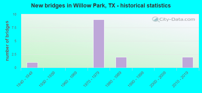
- New bridges - historical statistics
- 11940-1949
- 91970-1979
- 21980-1989
- 22010-2019


- Bridge Condition - Deck
- 9.1%Very good
- 72.7%Good
- 18.2%Satisfactory

- Bridge Condition - Superstructure
- 72.7%Good
- 27.3%Satisfactory

- Bridge Condition - Substructure
- 54.5%Good
- 36.4%Satisfactory
- 9.1%Fair

- Bridge Condition - Channel
- 25.0%Good
- 50.0%Satisfactory
- 25.0%Fair
Find on map >> Show street view
Structure Number: 21840000803037, Location: 1.2 MI E OF FM 5 (Lat: 32.739558, Lng: -97.652400), Route carried "on" structure: ServiceInterstate 20, Year Built: 1940, Status: Open, Structure Length: 10.36m (33.99ft), Average Daily Traffic: 771 (year 2018), Truck Traffic: 13%, Average Future Daily Traffic: 970 (year 2038), Design Load: H 15, Features Intersected: CLEAR FK TRINITY RIVER
Minimum Vertical Clearance: 30+ m (98+ ft), Kilometerpoint: 45.012, Lanes on structure: 2, Owner: State Highway Agency, Approaching Roadway Width: 7.9m (25.9ft), Material/Design: Steel, Design/Construction: Stringer/Multi-beam, Number Of Spans In Main Unit: 1, Number Of Approach Spans: 7, Length of Maximum Span: 18.3m (60.0ft), Curb-To-Curb Width: 7.9m (25.9ft), Out-to-Out Width: 9.5m (31.2ft)
Condition: Deck: Satisfactory, Superstructure: Satisfactory, Substructure: Satisfactory, Channel: Satisfactory, Operating Rating: 44.4 metric tons, Method Used To Determine Operating Rating: Load Factor (LF), Inventory Rating: 26.3 metric tons, Method Used To Determine Inventory Rating: Load Factor (LF), Structural Evaluation: Equal to present minimum criteria, Deck Geometry: High priority of replacement, Waterway Adequacy: Equal to present minimum criteria, Approach Roadway Alignment: Equal to present desirable criteria, Length Of Structure Improvement: 10.36m (33.99ft), Designated Inspection Frequency: Every 24 months, Inspection Date: September 2020, Bridge Improvement Cost: $854,000, Roadway Improvement Cost: $160,000, Total Project Cost: $1,014,000, Deck Structure Type: Concrete Cast-file-Place, Wearing Surface/Protective System: Wearing Surface: Bituminous
Find on map >> Show street view
Structure Number: 21840000803273, Location: IH 20 WB AT FM 5 (Lat: 32.747553, Lng: -97.673800), Route carried "on" structure: Interstate 20, Year Built: 1978, Status: Open, Structure Length: 7.86m (25.79ft), Average Daily Traffic: 46,568 (year 2019), Truck Traffic: 11%, Average Future Daily Traffic: 49,680 (year 2038), Design Load: HS 20, Features Intersected: FM 5
Minimum Vertical Clearance: 30+ m (98+ ft), Kilometerpoint: 42.825, Lanes on structure: 3, Lanes under structure: 5, Base Highway Network: Yes, Owner: State Highway Agency, Approaching Roadway Width: 17.1m (56.1ft), Skew: 3 degrees, Material/Design: Prestressed concrete, Design/Construction: Stringer/Multi-beam, Number Of Spans In Main Unit: 1, Number Of Approach Spans: 2, Length of Maximum Span: 29.9m (98.1ft), Curb-To-Curb Width: 18.3m (60.0ft), Out-to-Out Width: 18.8m (61.7ft)
Condition: Deck: Satisfactory, Superstructure: Good, Substructure: Good, Operating Rating: 54.4 metric tons, Method Used To Determine Operating Rating: Assigned rating based on Load Factor Design (LFD) reported in metric tons, Inventory Rating: 32.7 metric tons, Method Used To Determine Inventory Rating: Assigned rating based on Load Factor Design (LFD) reported in metric tons, Structural Evaluation: Better than present minimum criteria, Deck Geometry: Better than present minimum criteria, Underclear: Superior to present desirable criteria, Approach Roadway Alignment: Equal to present desirable criteria, Designated Inspection Frequency: Every 24 months, Inspection Date: September 2020, Deck Structure Type: Concrete Cast-file-Place, Wearing Surface/Protective System: Wearing Surface: Bituminous
Find on map >> Show street view
Structure Number: 21840000803275, Location: 1.2 MI E OF FM 5 (Lat: 32.740014, Lng: -97.652025), Route carried "on" structure: Interstate 20, Year Built: 1978, Status: Open, Structure Length: 10.36m (33.99ft), Average Daily Traffic: 46,568 (year 2019), Truck Traffic: 12%, Average Future Daily Traffic: 52,510 (year 2038), Design Load: HS 20, Features Intersected: CLEAR FK TRINITY RIVER
Minimum Vertical Clearance: 30+ m (98+ ft), Kilometerpoint: 45.012, Lanes on structure: 3, Base Highway Network: Yes, Owner: State Highway Agency, Approaching Roadway Width: 18.3m (60.0ft), Skew: 3 degrees, Material/Design: Prestressed concrete, Design/Construction: Stringer/Multi-beam, Number Of Spans In Main Unit: 4, Number Of Approach Spans: 1, Length of Maximum Span: 22.9m (75.1ft), Curb-To-Curb Width: 18.3m (60.0ft), Out-to-Out Width: 18.8m (61.7ft)
Condition: Deck: Good, Superstructure: Good, Substructure: Good, Channel: Good, Operating Rating: 54.4 metric tons, Method Used To Determine Operating Rating: Assigned rating based on Load Factor Design (LFD) reported in metric tons, Inventory Rating: 32.7 metric tons, Method Used To Determine Inventory Rating: Assigned rating based on Load Factor Design (LFD) reported in metric tons, Structural Evaluation: Better than present minimum criteria, Deck Geometry: Better than present minimum criteria, Waterway Adequacy: Superior to present desirable criteria, Approach Roadway Alignment: Equal to present desirable criteria, Designated Inspection Frequency: Every 24 months, Inspection Date: September 2020, Deck Structure Type: Concrete Cast-file-Place, Wearing Surface/Protective System: Wearing Surface: Bituminous
Find on map >> Show street view
Structure Number: 21840000803276, Location: 1.2 MI E OF FM 5 (Lat: 32.739883, Lng: -97.652072), Route carried "on" structure: Interstate 20, Year Built: 1978, Status: Open, Structure Length: 10.36m (33.99ft), Average Daily Traffic: 46,034 (year 2019), Truck Traffic: 12%, Average Future Daily Traffic: 52,510 (year 2038), Design Load: HS 20, Features Intersected: CLEAR FK TRINITY RIVER
Minimum Vertical Clearance: 30+ m (98+ ft), Kilometerpoint: 45.012, Lanes on structure: 3, Base Highway Network: Yes, Owner: State Highway Agency, Approaching Roadway Width: 18.3m (60.0ft), Skew: 3 degrees, Material/Design: Prestressed concrete, Design/Construction: Stringer/Multi-beam, Number Of Spans In Main Unit: 4, Number Of Approach Spans: 1, Length of Maximum Span: 22.9m (75.1ft), Curb-To-Curb Width: 18.3m (60.0ft), Out-to-Out Width: 18.8m (61.7ft)
Condition: Deck: Good, Superstructure: Good, Substructure: Good, Channel: Good, Operating Rating: 54.4 metric tons, Method Used To Determine Operating Rating: Assigned rating based on Load Factor Design (LFD) reported in metric tons, Inventory Rating: 32.7 metric tons, Method Used To Determine Inventory Rating: Assigned rating based on Load Factor Design (LFD) reported in metric tons, Structural Evaluation: Better than present minimum criteria, Deck Geometry: Better than present minimum criteria, Waterway Adequacy: Superior to present desirable criteria, Approach Roadway Alignment: Equal to present desirable criteria, Designated Inspection Frequency: Every 24 months, Inspection Date: September 2020, Deck Structure Type: Concrete Cast-file-Place, Wearing Surface/Protective System: Wearing Surface: Bituminous
Find on map >> Show street view
Structure Number: 21840000803277, Location: 1.2 MI E OF FM 5 (Lat: 32.740486, Lng: -97.652336), Route carried "on" structure: ServiceInterstate 20, Year Built: 1978, Status: Open, Structure Length: 10.36m (33.99ft), Average Daily Traffic: 2,320 (year 2018), Truck Traffic: 12%, Average Future Daily Traffic: 3,250 (year 2038), Design Load: HS 20, Features Intersected: CLEAR FK TRINITY RIVER
Minimum Vertical Clearance: 30+ m (98+ ft), Kilometerpoint: 45.012, Lanes on structure: 2, Owner: State Highway Agency, Approaching Roadway Width: 11.0m (36.1ft), Skew: 3 degrees, Material/Design: Prestressed concrete, Design/Construction: Stringer/Multi-beam, Number Of Spans In Main Unit: 4, Number Of Approach Spans: 1, Length of Maximum Span: 22.9m (75.1ft), Curb-To-Curb Width: 11.0m (36.1ft), Out-to-Out Width: 11.5m (37.7ft)
Condition: Deck: Good, Superstructure: Good, Substructure: Good, Channel: Fair, Operating Rating: 54.4 metric tons, Method Used To Determine Operating Rating: Assigned rating based on Load Factor Design (LFD) reported in metric tons, Inventory Rating: 32.7 metric tons, Method Used To Determine Inventory Rating: Assigned rating based on Load Factor Design (LFD) reported in metric tons, Structural Evaluation: Better than present minimum criteria, Deck Geometry: Somewhat better than minimum adequacy, Waterway Adequacy: Superior to present desirable criteria, Approach Roadway Alignment: Equal to present desirable criteria, Designated Inspection Frequency: Every 24 months, Inspection Date: September 2020, Deck Structure Type: Concrete Cast-file-Place, Wearing Surface/Protective System: Wearing Surface: Bituminous
Find on map >> Show street view
Structure Number: 21840000803278, Location: 2.0 MI W OF FM 1187 (Lat: 32.734631, Lng: -97.632753), Route carried "on" structure: Interstate 20, Year Built: 1978, Status: Open, Structure Length: 6.61m (21.69ft), Average Daily Traffic: 46,568 (year 2019), Truck Traffic: 12%, Average Future Daily Traffic: 52,510 (year 2038), Design Load: HS 20, Features Intersected: RANCH HOUSE RD
Minimum Vertical Clearance: 30+ m (98+ ft), Kilometerpoint: 46.949, Lanes on structure: 3, Lanes under structure: 6, Base Highway Network: Yes, Owner: State Highway Agency, Approaching Roadway Width: 18.3m (60.0ft), Material/Design: Prestressed concrete, Design/Construction: Stringer/Multi-beam, Number Of Spans In Main Unit: 3, Length of Maximum Span: 25.0m (82.0ft), Curb-To-Curb Width: 18.3m (60.0ft), Out-to-Out Width: 18.8m (61.7ft)
Condition: Deck: Good, Superstructure: Good, Substructure: Satisfactory, Operating Rating: 54.4 metric tons, Method Used To Determine Operating Rating: Assigned rating based on Load Factor Design (LFD) reported in metric tons, Inventory Rating: 32.7 metric tons, Method Used To Determine Inventory Rating: Assigned rating based on Load Factor Design (LFD) reported in metric tons, Structural Evaluation: Equal to present minimum criteria, Deck Geometry: Better than present minimum criteria, Underclear: Superior to present desirable criteria, Approach Roadway Alignment: Equal to present desirable criteria, Designated Inspection Frequency: Every 24 months, Inspection Date: September 2020, Deck Structure Type: Concrete Cast-file-Place, Wearing Surface/Protective System: Wearing Surface: Bituminous
Find on map >> Show street view
Structure Number: 21840000803279, Location: 2.0 MI W OF FM 1187 (Lat: 32.734453, Lng: -97.632847), Route carried "on" structure: Interstate 20, Year Built: 1978, Status: Open, Structure Length: 6.61m (21.69ft), Average Daily Traffic: 46,034 (year 2019), Truck Traffic: 12%, Average Future Daily Traffic: 52,510 (year 2038), Design Load: HS 20, Features Intersected: RANCH HOUSE RD
Minimum Vertical Clearance: 30+ m (98+ ft), Kilometerpoint: 46.949, Lanes on structure: 3, Lanes under structure: 6, Base Highway Network: Yes, Owner: State Highway Agency, Approaching Roadway Width: 18.3m (60.0ft), Material/Design: Prestressed concrete, Design/Construction: Stringer/Multi-beam, Number Of Spans In Main Unit: 3, Length of Maximum Span: 25.0m (82.0ft), Curb-To-Curb Width: 18.3m (60.0ft), Out-to-Out Width: 18.8m (61.7ft)
Condition: Deck: Good, Superstructure: Good, Substructure: Satisfactory, Operating Rating: 54.4 metric tons, Method Used To Determine Operating Rating: Assigned rating based on Load Factor Design (LFD) reported in metric tons, Inventory Rating: 32.7 metric tons, Method Used To Determine Inventory Rating: Assigned rating based on Load Factor Design (LFD) reported in metric tons, Structural Evaluation: Equal to present minimum criteria, Deck Geometry: Better than present minimum criteria, Underclear: Superior to present desirable criteria, Approach Roadway Alignment: Equal to present desirable criteria, Designated Inspection Frequency: Every 24 months, Inspection Date: September 2020, Deck Structure Type: Concrete Cast-file-Place, Wearing Surface/Protective System: Wearing Surface: Bituminous
Find on map >> Show street view
Structure Number: 21840AA0337001, Location: 0.9 MI. N. IH 20 (Lat: 32.752464, Lng: -97.664208), Route carried "on" structure: County highway , Year Built: 1981, Year Reconstructed: 2013, Status: Open, Structure Length: 2.44m (8.01ft), Average Daily Traffic: 1,164 (year 2014), Average Future Daily Traffic: 1,060 (year 2030), Features Intersected: CLEAR FK TRINITY RI, Facility Carried by Structure: CROWN ROAD - PCT 4
Minimum Vertical Clearance: 30+ m (98+ ft), Kilometerpoint: 0.917, Lanes on structure: 2, Owner: County Highway Agency, Approaching Roadway Width: 7.0m (23.0ft), Skew: 1 degrees, Material/Design: Steel continuous, Design/Construction: Stringer/Multi-beam, Number Of Spans In Main Unit: 1, Number Of Approach Spans: 2, Length of Maximum Span: 10.4m (34.1ft), Curb-To-Curb Width: 7.8m (25.6ft), Out-to-Out Width: 8.1m (26.6ft)
Condition: Deck: Good, Superstructure: Satisfactory, Substructure: Satisfactory, Channel: Satisfactory, Operating Rating: 32.7 metric tons, Method Used To Determine Operating Rating: Field evaluation and documented engineering judgment, Inventory Rating: 24.5 metric tons, Method Used To Determine Inventory Rating: Field evaluation and documented engineering judgment, Structural Evaluation: Equal to present minimum criteria, Deck Geometry: Meets minimum limits, Waterway Adequacy: Better than present minimum criteria, Approach Roadway Alignment: Equal to present minimum criteria, Length Of Structure Improvement: 2.44m (8.01ft), Designated Inspection Frequency: Every 24 months, Inspection Date: December 2019, Bridge Improvement Cost: $3,000, Roadway Improvement Cost: $1,000, Total Project Cost: $4,000, Deck Structure Type: Concrete Cast-file-Place
Find on map >> Show street view
Structure Number: 21840J00020002, Location: .1 MI N. OF IH 20 (Lat: 32.737347, Lng: -97.632433), Route carried "on" structure: City street , Year Built: 2012, Status: Open, Structure Length: 1.83m (6.00ft), Average Daily Traffic: 1,220 (year 2010), Average Future Daily Traffic: 1,270 (year 2029), Design Load: HL 93, Features Intersected: TRIB CLEAR FORK TRINITY, Facility Carried by Structure: RANCH HOUSE RD
Minimum Vertical Clearance: 30+ m (98+ ft), Kilometerpoint: 0.161, Lanes on structure: 2, Owner: City or Municipal Highway Agency, Approaching Roadway Width: 8.2m (26.9ft), Material/Design: Prestressed concrete, Design/Construction: Stringer/Multi-beam, Number Of Spans In Main Unit: 1, Length of Maximum Span: 18.3m (60.0ft), Curb or Sidewalk Widths: Left: 0.0m, Right: 1.5m (4.9ft), Curb-To-Curb Width: 8.2m (26.9ft), Out-to-Out Width: 10.4m (34.1ft)
Condition: Deck: Very good, Superstructure: Good, Substructure: Good, Channel: Fair, Operating Rating: 54.4 metric tons, Method Used To Determine Operating Rating: Assigned ratings based on Load and Resistance Factor Design (LRFD) reported in metric tons, Inventory Rating: 32.7 metric tons, Method Used To Determine Inventory Rating: Assigned ratings based on Load and Resistance Factor Design (LRFD) reported in metric tons, Structural Evaluation: Better than present minimum criteria, Deck Geometry: Meets minimum limits, Waterway Adequacy: Equal to present desirable criteria, Approach Roadway Alignment: Equal to present desirable criteria, Designated Inspection Frequency: Every 24 months, Inspection Date: December 2021, Deck Structure Type: Concrete Precast Panels
Find on map >> Show street view
Structure Number: 21840J00020003, Location: 0.1 MI W of Navajo Trail (Lat: 32.765433, Lng: -97.648497), Route carried "on" structure: City street , Year Built: 2012, Status: Open, Structure Length: 2.90m (9.51ft), Average Daily Traffic: 1,055 (year 2019), Average Future Daily Traffic: 1,270 (year 2029), Features Intersected: SQUAW CREEK, Facility Carried by Structure: RANCH HOUSE ROAD
Minimum Vertical Clearance: 30+ m (98+ ft), Kilometerpoint: 1.770, Lanes on structure: 2, Owner: City or Municipal Highway Agency, Approaching Roadway Width: 7.6m (24.9ft), Material/Design: Steel continuous, Design/Construction: Stringer/Multi-beam, Number Of Spans In Main Unit: 1, Number Of Approach Spans: 1, Length of Maximum Span: 17.7m (58.1ft), Curb-To-Curb Width: 7.6m (24.9ft), Out-to-Out Width: 7.6m (24.9ft)
Condition: Deck: Good, Superstructure: Good, Substructure: Good, Channel: Satisfactory, Operating Rating: 32.7 metric tons, Method Used To Determine Operating Rating: Field evaluation and documented engineering judgment, Inventory Rating: 24.5 metric tons, Method Used To Determine Inventory Rating: Field evaluation and documented engineering judgment, Structural Evaluation: Equal to present minimum criteria, Deck Geometry: Meets minimum limits, Waterway Adequacy: Better than present minimum criteria, Approach Roadway Alignment: Equal to present desirable criteria, Designated Inspection Frequency: Every 24 months, Inspection Date: December 2021, Deck Structure Type: Concrete Cast-file-Place
Find on map >> Show street view
Structure Number: 21840J00105001, Location: 0.1 MI N OF IH20 (Lat: 32.741417, Lng: -97.653219), Route carried "on" structure: City street , Year Built: 1980, Status: Posted for load, Structure Length: 2.44m (8.01ft), Average Daily Traffic: 587 (year 2019), Average Future Daily Traffic: 670 (year 2029), Features Intersected: CLEAR FORK TRINITY RIVER, Facility Carried by Structure: KINGS GATE RD
Minimum Vertical Clearance: 30+ m (98+ ft), Kilometerpoint: 0.045, Lanes on structure: 2, Owner: City or Municipal Highway Agency, Approaching Roadway Width: 6.4m (21.0ft), Material/Design: Steel continuous, Design/Construction: Stringer/Multi-beam, Number Of Spans In Main Unit: 1, Number Of Approach Spans: 2, Length of Maximum Span: 12.5m (41.0ft), Curb-To-Curb Width: 6.5m (21.3ft), Out-to-Out Width: 6.9m (22.6ft)
Condition: Deck: Good, Superstructure: Satisfactory, Substructure: Fair, Channel: Satisfactory, Operating Rating: 21.8 metric tons, Method Used To Determine Operating Rating: Load Factor (LF), Inventory Rating: 12.7 metric tons, Method Used To Determine Inventory Rating: Load Factor (LF), Structural Evaluation: Meets minimum limits, Deck Geometry: High priority of corrective action, Waterway Adequacy: Somewhat better than minimum adequacy, Approach Roadway Alignment: Equal to present desirable criteria, Bridge Posting: Required (Relationship of Operating Rating to Maximum Legal Load: > 39.9% below), Length Of Structure Improvement: 2.44m (8.01ft), Designated Inspection Frequency: Every 24 months, Inspection Date: December 2021, Bridge Improvement Cost: $46,000, Roadway Improvement Cost: $12,000, Total Project Cost: $59,000, Deck Structure Type: Concrete Cast-file-Place
Find on map >> Show street view
Structure Number: 21840000803273, Location: IH 20 WB AT FM 5 (Lat: 32.747553, Lng: -97.673800), Route carried "under" structure: State highway 5, Year Built: 1978, Structure Length: 0. m, Average Daily Traffic: 8,550 (year 2018), Truck Traffic: 2%, Features Intersected: FM 5, Facility Carried by Structure: IH 20 WB
Minimum Vertical Clearance: 5.33m (17.49ft), Kilometerpoint: 0.037, Lanes on structure: 3, Lanes under structure: 5, Material/Design: Prestressed concrete, Design/Construction: Stringer/Multi-beam, Length of Maximum Span: 29.9m (98.1ft)
Find on map >> Show street view
Structure Number: 21840000803278, Location: 2.0 MI W OF FM 1187 (Lat: 32.734631, Lng: -97.632753), Route carried "under" structure: City street , Year Built: 1978, Structure Length: 0. m, Average Daily Traffic: 8,345 (year 2018), Features Intersected: RANCH HOUSE RD, Facility Carried by Structure: IH 20 WB
Minimum Vertical Clearance: 6.02m (19.75ft), Kilometerpoint: 6.194, Lanes on structure: 3, Lanes under structure: 6, Material/Design: Prestressed concrete, Design/Construction: Stringer/Multi-beam, Length of Maximum Span: 25.0m (82.0ft)
Find on map >> Show street view
Structure Number: 21840000803279, Location: 2.0 MI W OF FM 1187 (Lat: 32.734453, Lng: -97.632847), Route carried "under" structure: City street , Year Built: 1978, Structure Length: 0. m, Average Daily Traffic: 8,345 (year 2018), Features Intersected: RANCH HOUSE RD, Facility Carried by Structure: IH 20 EB
Minimum Vertical Clearance: 5.74m (18.83ft), Kilometerpoint: 6.223, Lanes on structure: 3, Lanes under structure: 6, Material/Design: Prestressed concrete, Design/Construction: Stringer/Multi-beam, Length of Maximum Span: 25.0m (82.0ft)