Bridge Statistics for Willowbrook, Illinois (IL)
Condition, Traffic, Stress, Structural Evaluation, Project Costs
- National Bridge Inventory (NBI) Statistics
- 16Number of bridges
- 108ft / 33.3mTotal length
- 506,250Total average daily traffic
- 50,450Total average daily truck traffic
- National Bridge Inventory (NBI) Registered Bridges for Willowbrook
- No street view available for this location
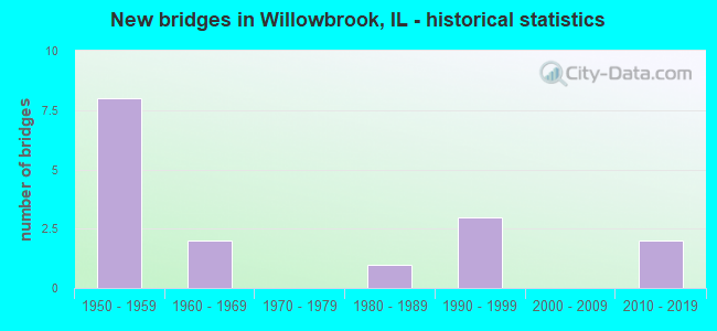
- New bridges - historical statistics
- 81950-1959
- 21960-1969
- 11980-1989
- 31990-1999
- 22010-2019


- Bridge Condition - Deck
- 42.9%Good
- 42.9%Satisfactory
- 14.3%Fair

- Bridge Condition - Superstructure
- 14.3%Very good
- 28.6%Good
- 28.6%Satisfactory
- 28.6%Fair

- Bridge Condition - Substructure
- 28.6%Very good
- 57.1%Good
- 14.3%Fair

- Bridge Condition - Channel
- 50.0%Very good
- 25.0%Good
- 12.5%Satisfactory
- 12.5%Fair

- Bridge Condition - Culverts
- 66.7%Very good
- 33.3%Satisfactory
Find on map >> Show street view
Structure Number: 22005, Location: 1.2 MI NW COOK CO (Lat: 41.741911, Lng: -87.944531), Route carried "on" structure: State highway 83, Year Built: 1959, Year Reconstructed: 2001, Status: Open, Structure Length: 10.44m (34.25ft), Average Daily Traffic: 44,400 (year 2021), Truck Traffic: 8%, Average Future Daily Traffic: 26,235 (year 2032), Design Load: HS 20, Features Intersected: I- 55
Minimum Vertical Clearance: 30+ m (98+ ft), Kilometerpoint: 56.293, Lanes on structure: 3, Lanes under structure: 12, Base Highway Network: Yes, Owner: State Highway Agency, Approaching Roadway Width: 15.8m (51.8ft), Skew: 2 degrees, Material/Design: Steel continuous, Design/Construction: Stringer/Multi-beam, Number Of Spans In Main Unit: 4, Length of Maximum Span: 28.1m (92.2ft), Curb-To-Curb Width: 17.7m (58.1ft), Out-to-Out Width: 18.7m (61.4ft)
Condition: Deck: Good, Superstructure: Good, Substructure: Good, Operating Rating: 89.1 metric tons, Method Used To Determine Operating Rating: Load Factor (LF) rating reported by rating factor (RF) method using MS18 loading, Inventory Rating: 53.5 metric tons, Method Used To Determine Inventory Rating: Load Factor (LF) rating reported by rating factor (RF) method using MS18 loading, Structural Evaluation: Better than present minimum criteria, Deck Geometry: Superior to present desirable criteria, Underclear: Somewhat better than minimum adequacy, Approach Roadway Alignment: Equal to present desirable criteria, Designated Inspection Frequency: Every 24 months, Inspection Date: October 2020, Deck Structure Type: Concrete Cast-file-Place, Wearing Surface/Protective System: Deck Protection: Epoxy Coated Reinforcing
Find on map >> Show street view
Structure Number: 220051, Location: 1.2 M NW OF COOK CO (Lat: 41.741772, Lng: -87.944525), Route carried "on" structure: State highway 83, Year Built: 1959, Year Reconstructed: 2001, Status: Open, Structure Length: 10.44m (34.25ft), Average Daily Traffic: 28,700 (year 2021), Truck Traffic: 8%, Average Future Daily Traffic: 26,235 (year 2032), Design Load: HS 20, Features Intersected: I- 55
Minimum Vertical Clearance: 30+ m (98+ ft), Kilometerpoint: 56.277, Lanes on structure: 3, Lanes under structure: 12, Base Highway Network: Yes, Owner: State Highway Agency, Approaching Roadway Width: 15.8m (51.8ft), Skew: 2 degrees, Material/Design: Steel continuous, Design/Construction: Stringer/Multi-beam, Number Of Spans In Main Unit: 4, Length of Maximum Span: 28.1m (92.2ft), Curb-To-Curb Width: 17.7m (58.1ft), Out-to-Out Width: 18.7m (61.4ft)
Condition: Deck: Good, Superstructure: Good, Substructure: Good, Operating Rating: 89.1 metric tons, Method Used To Determine Operating Rating: Load Factor (LF) rating reported by rating factor (RF) method using MS18 loading, Inventory Rating: 53.5 metric tons, Method Used To Determine Inventory Rating: Load Factor (LF) rating reported by rating factor (RF) method using MS18 loading, Structural Evaluation: Better than present minimum criteria, Deck Geometry: Superior to present desirable criteria, Underclear: Somewhat better than minimum adequacy, Approach Roadway Alignment: Equal to present desirable criteria, Designated Inspection Frequency: Every 24 months, Inspection Date: October 2020, Deck Structure Type: Concrete Cast-file-Place, Wearing Surface/Protective System: Deck Protection: Epoxy Coated Reinforcing
Find on map >> Show street view
Structure Number: 220174, Location: N OF 63RD ST (Lat: 41.776347, Lng: -87.946844), Route carried "on" structure: State highway 83, Year Built: 1990, Status: Open, Structure Length: 0.81m (2.66ft), Average Daily Traffic: 51,100 (year 2021), Truck Traffic: 7%, Average Future Daily Traffic: 30,635 (year 2032), Design Load: HS 20, Features Intersected: DRAINAGE DITCH
Minimum Vertical Clearance: 30+ m (98+ ft), Kilometerpoint: 60.140, Lanes on structure: 4, Base Highway Network: Yes, Owner: State Highway Agency, Approaching Roadway Width: 21.9m (71.9ft), Skew: 6 degrees, Material/Design: Concrete, Design/Construction: Culvert, Number Of Spans In Main Unit: 2, Length of Maximum Span: 1.8m (5.9ft), Curb-To-Curb Width: 21.9m (71.9ft), Out-to-Out Width: 34.1m (111.9ft)
Condition: Channel: Very good, Culverts: Very good, Operating Rating: 44.1 metric tons, Method Used To Determine Operating Rating: Load Factor (LF) rating reported by rating factor (RF) method using MS18 loading, Inventory Rating: 32.4 metric tons, Method Used To Determine Inventory Rating: Load Factor (LF) rating reported by rating factor (RF) method using MS18 loading, Structural Evaluation: Equal to present desirable criteria, Deck Geometry: Superior to present desirable criteria, Waterway Adequacy: Better than present minimum criteria, Approach Roadway Alignment: Equal to present desirable criteria, Designated Inspection Frequency: Every 48 months, Inspection Date: October 2019
Find on map >> Show street view
Structure Number: 220563, Location: 0.05 M N of 63rd (Lat: 41.775025, Lng: -87.946789), Route carried "on" structure: State highway 83, Year Built: 2015, Status: Open, Structure Length: 1.55m (5.09ft), Average Daily Traffic: 51,100 (year 2021), Truck Traffic: 7%, Average Future Daily Traffic: 57,100 (year 2041), Design Load: HS 25 or greater, Features Intersected: MARION HILLS DITCH
Minimum Vertical Clearance: 30+ m (98+ ft), Kilometerpoint: 59.995, Lanes on structure: 6, Base Highway Network: Yes, Owner: State Highway Agency, Approaching Roadway Width: 34.1m (111.9ft), Skew: 30 degrees, Material/Design: Concrete continuous, Design/Construction: Culvert, Number Of Spans In Main Unit: 4, Length of Maximum Span: 3.7m (12.1ft)
Condition: Channel: Very good, Culverts: Very good, Operating Rating: 70.0 metric tons, Method Used To Determine Operating Rating: Load and Resistance Factor Rating (LRFR) rating reported by rating factor(RF) method using HL-93 loadings, Inventory Rating: 54.1 metric tons, Method Used To Determine Inventory Rating: Load and Resistance Factor Rating (LRFR) rating reported by rating factor(RF) method using HL-93 loadings, Structural Evaluation: Equal to present desirable criteria, Waterway Adequacy: Equal to present desirable criteria, Approach Roadway Alignment: Equal to present desirable criteria, Designated Inspection Frequency: Every 48 months, Inspection Date: Febuary 2022, Deck Structure Type: Other
Find on map >> Show street view
Structure Number: 223036, Location: 0.3 MI N I-55 (Lat: 41.741194, Lng: -87.953961), Route carried "on" structure: Other road , Year Built: 1963, Status: Open, Structure Length: 0.94m (3.08ft), Average Daily Traffic: 5,250 (year 2020), Truck Traffic: 4%, Average Future Daily Traffic: 7,241 (year 2032), Design Load: HS 20, Features Intersected: SAWMILL CREEK, Facility Carried by Structure: CLARENDON HILLS RD
Minimum Vertical Clearance: 30+ m (98+ ft), Kilometerpoint: 5.246, Lanes on structure: 2, Owner: Town or Township Highway Agency, Approaching Roadway Width: 8.2m (26.9ft), Material/Design: Prestressed concrete, Design/Construction: Box Beam or Girders - Multiple, Number Of Spans In Main Unit: 1, Length of Maximum Span: 8.7m (28.5ft), Curb-To-Curb Width: 8.2m (26.9ft), Out-to-Out Width: 9.1m (29.9ft)
Condition: Deck: Fair, Superstructure: Fair, Substructure: Fair, Channel: Fair, Operating Rating: 89.1 metric tons, Method Used To Determine Operating Rating: Allowable Stress (AS) rating reported by rating factor (RF) method using MS18 loading, Inventory Rating: 59.6 metric tons, Method Used To Determine Inventory Rating: Allowable Stress (AS) rating reported by rating factor (RF) method using MS18 loading, Structural Evaluation: Somewhat better than minimum adequacy, Deck Geometry: High priority of replacement, Waterway Adequacy: Better than present minimum criteria, Approach Roadway Alignment: Equal to present desirable criteria, Designated Inspection Frequency: Every 24 months, Inspection Date: September 2021, Deck Structure Type: Concrete Precast Panels, Wearing Surface/Protective System: Wearing Surface: Bituminous
Find on map >> Show street view
Structure Number: 223124, Location: 0.1 E IL 83 (Lat: 41.774261, Lng: -87.945700), Route carried "on" structure: County highway , Year Built: 1981, Status: Open, Structure Length: 1.31m (4.30ft), Average Daily Traffic: 9,200 (year 2020), Truck Traffic: 3%, Average Future Daily Traffic: 13,702 (year 2032), Design Load: HS 20, Features Intersected: FLAGG CREEK TRIB, Facility Carried by Structure: CH38 - 63RD ST
Minimum Vertical Clearance: 30+ m (98+ ft), Kilometerpoint: 0.064, Lanes on structure: 6, Owner: County Highway Agency, Approaching Roadway Width: 20.1m (65.9ft), Material/Design: Concrete, Design/Construction: Culvert, Number Of Spans In Main Unit: 5, Length of Maximum Span: 2.3m (7.5ft), Curb or Sidewalk Widths: Left: 0.0m, Right: 1.5m (4.9ft), Curb-To-Curb Width: 14.6m (47.9ft), Out-to-Out Width: 14.6m (47.9ft)
Condition: Channel: Satisfactory, Culverts: Satisfactory, Operating Rating: 54.1 metric tons, Method Used To Determine Operating Rating: Field evaluation and documented engineering judgment, Inventory Rating: 32.4 metric tons, Method Used To Determine Inventory Rating: Field evaluation and documented engineering judgment, Structural Evaluation: Equal to present minimum criteria, Deck Geometry: High priority of replacement, Waterway Adequacy: Equal to present minimum criteria, Approach Roadway Alignment: Equal to present desirable criteria, Designated Inspection Frequency: Every 24 months, Inspection Date: June 2020
Find on map >> Show street view
Structure Number: 226004, Location: .25 Mi W of Madison (Lat: 41.771086, Lng: -87.939400), Route carried "on" structure: City street , Year Built: 1997, Year Reconstructed: 2002, Status: Open, Structure Length: 1.10m (3.61ft), Average Daily Traffic: 100 (year 2020), Truck Traffic: 26%, Average Future Daily Traffic: 1,200 (year 2038), Design Load: HS 20, Features Intersected: 63rd Street Ditch, Facility Carried by Structure: Lane Court
Minimum Vertical Clearance: 30+ m (98+ ft), Kilometerpoint: 0.129, Lanes on structure: 1, Owner: City or Municipal Highway Agency, Approaching Roadway Width: 4.1m (13.5ft), Material/Design: Steel, Design/Construction: Truss - Thru, Number Of Spans In Main Unit: 1, Length of Maximum Span: 10.7m (35.1ft), Curb-To-Curb Width: 4.1m (13.5ft), Out-to-Out Width: 4.1m (13.5ft)
Condition: Deck: Satisfactory, Superstructure: Fair, Substructure: Very good, Channel: Very good, Operating Rating: 53.8 metric tons, Method Used To Determine Operating Rating: Assigned rating based on Load Factor Design (LFD) reported by rating factor (RF) using MS18 loading, Inventory Rating: 32.4 metric tons, Method Used To Determine Inventory Rating: Assigned rating based on Load Factor Design (LFD) reported by rating factor (RF) using MS18 loading, Structural Evaluation: Somewhat better than minimum adequacy, Deck Geometry: Somewhat better than minimum adequacy, Waterway Adequacy: Superior to present desirable criteria, Approach Roadway Alignment: Equal to present desirable criteria, Designated Inspection Frequency: Every 24 months, Critical Feature Inspection Frequency: Every 24 months, Inspection Date: April 2021, Critical Feature Inspection Date: April 2021, Deck Structure Type: Corrugated Steel, Wearing Surface/Protective System: Wearing Surface: Bituminous
Find on map >> Show street view
Structure Number: 993286, Location: 1.4 M E ILL RTE 394 (Lat: 41.455958, Lng: -87.545961), Route carried "on" structure: County highway , Year Built: 2014, Status: Open, Structure Length: 3.38m (11.09ft), Average Future Daily Traffic: 145 (year 2032), Design Load: HS 25 or greater, Features Intersected: PLUM CREEK, Facility Carried by Structure: RICHTON RD (TR 219
Minimum Vertical Clearance: 30+ m (98+ ft), Kilometerpoint: 0.241, Lanes on structure: 2, Owner: Town or Township Highway Agency, Approaching Roadway Width: 9.1m (29.9ft), Material/Design: Prestressed concrete, Design/Construction: Stringer/Multi-beam, Number Of Spans In Main Unit: 1, Length of Maximum Span: 32.7m (107.3ft), Curb-To-Curb Width: 9.1m (29.9ft), Out-to-Out Width: 10.2m (33.5ft)
Condition: Deck: Good, Superstructure: Very good, Substructure: Very good, Channel: Very good, Operating Rating: 42.1 metric tons, Method Used To Determine Operating Rating: Assigned ratings based on Load and Resistance Factor Design (LRFD) reported by rating factor (RF) using HL93 loadings, Inventory Rating: 32.4 metric tons, Method Used To Determine Inventory Rating: Assigned ratings based on Load and Resistance Factor Design (LRFD) reported by rating factor (RF) using HL93 loadings, Structural Evaluation: Equal to present desirable criteria, Deck Geometry: Better than present minimum criteria, Waterway Adequacy: Superior to present desirable criteria, Approach Roadway Alignment: Equal to present minimum criteria, Designated Inspection Frequency: Every 24 months, Inspection Date: July 2020, Deck Structure Type: Concrete Cast-file-Place, Wearing Surface/Protective System: Deck Protection: Epoxy Coated Reinforcing
Find on map >> Show street view
Structure Number: 993354, Location: 0.3 M W STATE LI RD (Lat: 41.436131, Lng: -87.531647), Route carried "on" structure: Other road , Year Built: 1996, Status: Open, Structure Length: 1.02m (3.35ft), Average Daily Traffic: 16,200 (year 2019), Truck Traffic: 9%, Average Future Daily Traffic: 17,567 (year 2032), Design Load: HS 20, Features Intersected: KLEMME CREEK, Facility Carried by Structure: EXCHANGE ST
Minimum Vertical Clearance: 30+ m (98+ ft), Kilometerpoint: 14.661, Lanes on structure: 2, Base Highway Network: Yes, Owner: County Highway Agency, Approaching Roadway Width: 12.2m (40.0ft), Material/Design: Concrete, Design/Construction: Slab, Number Of Spans In Main Unit: 1, Number Of Approach Spans: 2, Length of Maximum Span: 9.5m (31.2ft), Curb-To-Curb Width: 12.2m (40.0ft), Out-to-Out Width: 13.0m (42.7ft)
Condition: Deck: Satisfactory, Superstructure: Satisfactory, Substructure: Good, Channel: Good, Operating Rating: 44.1 metric tons, Method Used To Determine Operating Rating: Assigned rating based on Load Factor Design (LFD) reported by rating factor (RF) using MS18 loading, Inventory Rating: 32.4 metric tons, Method Used To Determine Inventory Rating: Assigned rating based on Load Factor Design (LFD) reported by rating factor (RF) using MS18 loading, Structural Evaluation: Equal to present minimum criteria, Deck Geometry: Somewhat better than minimum adequacy, Waterway Adequacy: Equal to present desirable criteria, Approach Roadway Alignment: Equal to present desirable criteria, Designated Inspection Frequency: Every 24 months, Inspection Date: April 2021, Deck Structure Type: Concrete Cast-file-Place, Wearing Surface/Protective System: Deck Protection: Epoxy Coated Reinforcing
Find on map >> Show street view
Structure Number: 993362, Location: 0.8 MI W INDIANA LIN (Lat: 41.436061, Lng: -87.540583), Route carried "on" structure: Other road , Year Built: 1964, Status: Open, Structure Length: 2.26m (7.41ft), Average Daily Traffic: 16,200 (year 2019), Truck Traffic: 9%, Average Future Daily Traffic: 17,567 (year 2032), Features Intersected: KLEMME CREEK, Facility Carried by Structure: EXCHANGE ST
Minimum Vertical Clearance: 30+ m (98+ ft), Kilometerpoint: 13.904, Lanes on structure: 2, Base Highway Network: Yes, Owner: County Highway Agency, Approaching Roadway Width: 12.2m (40.0ft), Skew: 5 degrees, Material/Design: Prestressed concrete, Design/Construction: Stringer/Multi-beam, Number Of Spans In Main Unit: 1, Number Of Approach Spans: 2, Length of Maximum Span: 21.4m (70.2ft), Curb-To-Curb Width: 12.2m (40.0ft), Out-to-Out Width: 13.0m (42.7ft)
Condition: Deck: Satisfactory, Superstructure: Satisfactory, Substructure: Good, Channel: Good, Operating Rating: 72.9 metric tons, Method Used To Determine Operating Rating: Load Factor (LF) rating reported by rating factor (RF) method using MS18 loading, Inventory Rating: 43.7 metric tons, Method Used To Determine Inventory Rating: Load Factor (LF) rating reported by rating factor (RF) method using MS18 loading, Structural Evaluation: Equal to present minimum criteria, Deck Geometry: Somewhat better than minimum adequacy, Waterway Adequacy: Equal to present desirable criteria, Approach Roadway Alignment: Equal to present desirable criteria, Designated Inspection Frequency: Every 24 months, Inspection Date: April 2021, Deck Structure Type: Concrete Cast-file-Place, Wearing Surface/Protective System: Deck Protection: Epoxy Coated Reinforcing
Find on map >> Show street view
Structure Number: 22005, Location: 1.2 MI NW COOK CO (Lat: 41.741381, Lng: -87.944508), Route carried "under" structure: Interstate 55, Year Built: 1959, Structure Length: 0. m, Average Daily Traffic: 121,500 (year 2021), Truck Traffic: 14%, Features Intersected: I- 55, Facility Carried by Structure: IL 83 SB
Minimum Vertical Clearance: 5.00m (16.40ft), Kilometerpoint: 441.833, Lanes on structure: 3, Lanes under structure: 10, Material/Design: Steel continuous, Design/Construction: Stringer/Multi-beam, Length of Maximum Span: 28.1m (92.2ft)
Find on map >> Show street view
Structure Number: 22005, Location: 1.2 MI NW COOK CO (Lat: 41.741303, Lng: -87.944336), Route carried "under" structure: Other road , Year Built: 1959, Structure Length: 0. m, Average Daily Traffic: 10,400 (year 2021), Features Intersected: I- 55, Facility Carried by Structure: IL 83 SB
Minimum Vertical Clearance: 5.08m (16.67ft), Kilometerpoint: 0.483, Lanes on structure: 3, Lanes under structure: 1, Material/Design: Steel continuous, Design/Construction: Stringer/Multi-beam, Length of Maximum Span: 28.1m (92.2ft)
Find on map >> Show street view
Structure Number: 22005, Location: 1.2 MI NW COOK CO (Lat: 41.741772, Lng: -87.944525), Route carried "under" structure: Other road , Year Built: 1959, Structure Length: 0. m, Average Daily Traffic: 10,100 (year 2021), Features Intersected: I- 55, Facility Carried by Structure: IL 83 SB
Minimum Vertical Clearance: 5.13m (16.83ft), Kilometerpoint: 0.563, Lanes on structure: 3, Lanes under structure: 1, Material/Design: Steel continuous, Design/Construction: Stringer/Multi-beam, Length of Maximum Span: 28.1m (92.2ft)
Find on map >> Show street view
Structure Number: 220051, Location: 1.2 M NW OF COOK CO (Lat: 41.741511, Lng: -87.944211), Route carried "under" structure: Interstate 55, Year Built: 1959, Structure Length: 0. m, Average Daily Traffic: 121,500 (year 2021), Truck Traffic: 14%, Features Intersected: I- 55, Facility Carried by Structure: IL 83 NB
Minimum Vertical Clearance: 5.41m (17.75ft), Kilometerpoint: 441.866, Lanes on structure: 3, Lanes under structure: 10, Material/Design: Steel continuous, Design/Construction: Stringer/Multi-beam, Length of Maximum Span: 28.1m (92.2ft)
Find on map >> Show street view
Structure Number: 220051, Location: 1.2 M NW OF COOK CO (Lat: 41.741900, Lng: -87.944231), Route carried "under" structure: Other road , Year Built: 1959, Structure Length: 0. m, Average Daily Traffic: 10,100 (year 2021), Features Intersected: I- 55, Facility Carried by Structure: IL 83 NB
Minimum Vertical Clearance: 5.41m (17.75ft), Kilometerpoint: 0.531, Lanes on structure: 3, Lanes under structure: 1, Material/Design: Steel continuous, Design/Construction: Stringer/Multi-beam, Length of Maximum Span: 28.1m (92.2ft)
Find on map >> Show street view
Structure Number: 220051, Location: 1.2 M NW OF COOK CO (Lat: 41.741414, Lng: -87.944086), Route carried "under" structure: Other road , Year Built: 1959, Structure Length: 0. m, Average Daily Traffic: 10,400 (year 2021), Features Intersected: I- 55, Facility Carried by Structure: IL 83 NB
Minimum Vertical Clearance: 5.49m (18.01ft), Kilometerpoint: 0.515, Lanes on structure: 3, Lanes under structure: 1, Material/Design: Steel continuous, Design/Construction: Stringer/Multi-beam, Length of Maximum Span: 28.1m (92.2ft)