Bridge Statistics for Wilmington Manor, Delaware (DE)
Condition, Traffic, Stress, Structural Evaluation, Project Costs
- National Bridge Inventory (NBI) Statistics
- 11Number of bridges
- 197ft / 59.8mTotal length
- $10,945,000Total costs
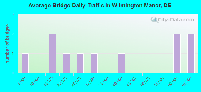
- 365,934Total average daily traffic
- 35,539Total average daily truck traffic
- National Bridge Inventory (NBI) Registered Bridges for Wilmington Manor
- No street view available for this location
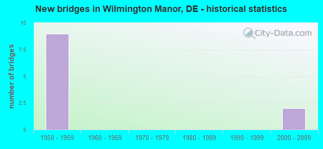
- New bridges - historical statistics
- 91950-1959
- 22000-2009
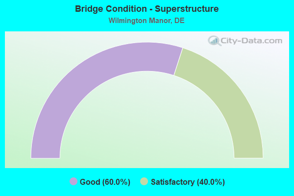
- Bridge Condition - Superstructure
- 60.0%Good
- 40.0%Satisfactory
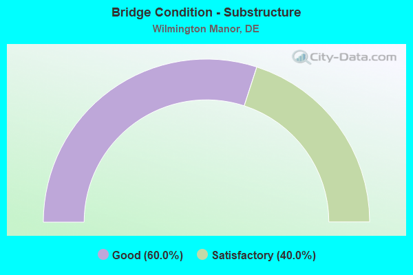
- Bridge Condition - Substructure
- 60.0%Good
- 40.0%Satisfactory
Find on map >> Show street view
Structure Number: 1666 033, Location: FARNHURST (Lat: 39.698389, Lng: -75.572917), Route carried "on" structure: US 33, Year Built: 2003, Status: Open, Structure Length: 1.72m (5.64ft), Average Daily Traffic: 17,648 (year 2019), Truck Traffic: 9%, Average Future Daily Traffic: 21,935 (year 2042), Design Load: HS 25 or greater, Features Intersected: I295 SOUTH TO US13 SOUTH, Facility Carried by Structure: DUPONT HWY/US13NB
Minimum Vertical Clearance: 30.48m (100.00ft), Kilometerpoint: 5.729, Lanes on structure: 4, Lanes under structure: 1, Base Highway Network: Yes, Owner: Local Toll Authority, Approaching Roadway Width: 14.6m (47.9ft), Material/Design: Steel, Design/Construction: Stringer/Multi-beam, Number Of Spans In Main Unit: 1, Length of Maximum Span: 17.2m (56.4ft), Curb-To-Curb Width: 20.7m (67.9ft), Out-to-Out Width: 23.1m (75.8ft)
Condition: Deck: Good, Superstructure: Good, Substructure: Good, Operating Rating: 88.1 metric tons, Method Used To Determine Operating Rating: Load and Resistance Factor Rating (LRFR) rating reported by rating factor(RF) method using HL-93 loadings, Inventory Rating: 68.0 metric tons, Method Used To Determine Inventory Rating: Load and Resistance Factor Rating (LRFR) rating reported by rating factor(RF) method using HL-93 loadings, Structural Evaluation: Better than present minimum criteria, Deck Geometry: Superior to present desirable criteria, Underclear: Better than present minimum criteria, Approach Roadway Alignment: Equal to present desirable criteria, Designated Inspection Frequency: Every 24 months, Inspection Date: April 2020, Deck Structure Type: Concrete Cast-file-Place, Wearing Surface/Protective System: Wearing Surface: Latex Concrete
Find on map >> Show street view
Structure Number: 1680 006, Location: BASIN CORNER (Lat: 39.680486, Lng: -75.590372), Route carried "on" structure: State highway 141, Year Built: 1955, Year Reconstructed: 2018, Status: Open, Structure Length: 18.35m (60.20ft), Average Daily Traffic: 21,517 (year 2019), Truck Traffic: 9%, Average Future Daily Traffic: 26,744 (year 2042), Design Load: HS 20, Features Intersected: US 13
Minimum Vertical Clearance: 30.48m (100.00ft), Kilometerpoint: 1.710, Lanes on structure: 4, Lanes under structure: 10, Base Highway Network: Yes, Owner: State Highway Agency, Approaching Roadway Width: 16.8m (55.1ft), Skew: 32 degrees, Material/Design: Steel continuous, Design/Construction: Stringer/Multi-beam, Number Of Spans In Main Unit: 7, Length of Maximum Span: 30.3m (99.4ft), Curb or Sidewalk Widths: Left: 0.0m, Right: 1.5m (4.9ft), Curb-To-Curb Width: 17.4m (57.1ft), Out-to-Out Width: 18.6m (61.0ft)
Condition: Deck: Good, Superstructure: Satisfactory, Substructure: Good, Operating Rating: 36.3 metric tons, Method Used To Determine Operating Rating: Load and Resistance Factor Rating (LRFR) rating reported by rating factor(RF) method using HL-93 loadings, Inventory Rating: 27.9 metric tons, Method Used To Determine Inventory Rating: Load and Resistance Factor Rating (LRFR) rating reported by rating factor(RF) method using HL-93 loadings, Structural Evaluation: Equal to present minimum criteria, Deck Geometry: Somewhat better than minimum adequacy, Underclear: High priority of corrective action, Approach Roadway Alignment: Equal to present desirable criteria, Length Of Structure Improvement: 18.35m (60.20ft), Designated Inspection Frequency: Every 24 months, Inspection Date: May 2020, Bridge Improvement Cost: $3,672,000, Roadway Improvement Cost: $367,000, Total Project Cost: $5,508,000, Deck Structure Type: Concrete Cast-file-Place, Wearing Surface/Protective System: Wearing Surface: Latex Concrete
Find on map >> Show street view
Structure Number: 1727 056, Location: FARNHURST (Lat: 39.695253, Lng: -75.576839), Route carried "on" structure: Interstate 295, Year Built: 1958, Status: Open, Structure Length: 12.83m (42.09ft), Average Daily Traffic: 61,768 (year 2019), Truck Traffic: 9%, Average Future Daily Traffic: 76,773 (year 2042), Design Load: HS 20+Mod, Features Intersected: US 13 NB
Minimum Vertical Clearance: 30.48m (100.00ft), Kilometerpoint: 19.890, Lanes on structure: 2, Lanes under structure: 5, Base Highway Network: Yes, Owner: Local Toll Authority, Approaching Roadway Width: 18.6m (61.0ft), Skew: 2 degrees, Material/Design: Steel, Design/Construction: Stringer/Multi-beam, Number Of Spans In Main Unit: 6, Length of Maximum Span: 27.6m (90.6ft), Curb or Sidewalk Widths: Left: 0.8m (2.6ft), Right: 0.8m (2.6ft), Curb-To-Curb Width: 14.3m (46.9ft), Out-to-Out Width: 15.2m (49.9ft)
Condition: Deck: Good, Superstructure: Satisfactory, Substructure: Satisfactory, Operating Rating: 43.1 metric tons, Method Used To Determine Operating Rating: Load and Resistance Factor Rating (LRFR) rating reported by rating factor(RF) method using HL-93 loadings, Inventory Rating: 33.0 metric tons, Method Used To Determine Inventory Rating: Load and Resistance Factor Rating (LRFR) rating reported by rating factor(RF) method using HL-93 loadings, Structural Evaluation: Equal to present minimum criteria, Deck Geometry: Superior to present desirable criteria, Underclear: Equal to present minimum criteria, Approach Roadway Alignment: Equal to present desirable criteria, Designated Inspection Frequency: Every 24 months, Inspection Date: April 2020, Deck Structure Type: Concrete Cast-file-Place, Wearing Surface/Protective System: Wearing Surface: Latex Concrete
Find on map >> Show street view
Structure Number: 1728 6116, Location: FARNHURST (Lat: 39.695467, Lng: -75.576964), Route carried "on" structure: Ramp Interstate 295, Year Built: 1958, Status: Open, Structure Length: 5.03m (16.50ft), Average Daily Traffic: 3,284 (year 2016), Truck Traffic: 11%, Average Future Daily Traffic: 4,239 (year 2043), Design Load: HS 20, Features Intersected: US13, RD33 SB.
Minimum Vertical Clearance: 30.48m (100.00ft), Kilometerpoint: 0.209, Lanes on structure: 1, Lanes under structure: 3, Owner: Local Toll Authority, Approaching Roadway Width: 8.5m (27.9ft), Skew: 2 degrees, Material/Design: Steel, Design/Construction: Stringer/Multi-beam, Number Of Spans In Main Unit: 3, Length of Maximum Span: 24.7m (81.0ft), Curb-To-Curb Width: 8.5m (27.9ft), Out-to-Out Width: 9.4m (30.8ft)
Condition: Deck: Good, Superstructure: Good, Substructure: Satisfactory, Operating Rating: 44.4 metric tons, Method Used To Determine Operating Rating: Load and Resistance Factor Rating (LRFR) rating reported by rating factor(RF) method using HL-93 loadings, Inventory Rating: 34.0 metric tons, Method Used To Determine Inventory Rating: Load and Resistance Factor Rating (LRFR) rating reported by rating factor(RF) method using HL-93 loadings, Structural Evaluation: Equal to present minimum criteria, Deck Geometry: Superior to present desirable criteria, Underclear: Equal to present minimum criteria, Approach Roadway Alignment: Equal to present desirable criteria, Designated Inspection Frequency: Every 24 months, Inspection Date: March 2021, Deck Structure Type: Concrete Cast-file-Place, Wearing Surface/Protective System: Wearing Surface: Latex Concrete
Find on map >> Show street view
Structure Number: 1729 056, Location: FARNHURST (Lat: 39.695964, Lng: -75.575911), Route carried "on" structure: Interstate 295, Year Built: 1958, Year Reconstructed: 2019, Status: Open, Structure Length: 21.91m (71.88ft), Average Daily Traffic: 61,296 (year 2018), Truck Traffic: 15%, Average Future Daily Traffic: 77,640 (year 2043), Design Load: HS 20+Mod, Features Intersected: US13 & I295S-US13SB RAMP
Minimum Vertical Clearance: 30.48m (100.00ft), Kilometerpoint: 32.140, Lanes on structure: 3, Lanes under structure: 9, Base Highway Network: Yes, Owner: Local Toll Authority, Approaching Roadway Width: 18.6m (61.0ft), Skew: 16 degrees, Material/Design: Steel, Design/Construction: Stringer/Multi-beam, Number Of Spans In Main Unit: 7, Length of Maximum Span: 38.6m (126.6ft), Curb or Sidewalk Widths: Left: 0.5m (1.6ft), Right: 0.5m (1.6ft), Curb-To-Curb Width: 12.5m (41.0ft), Out-to-Out Width: 22.9m (75.1ft)
Condition: Deck: Good, Superstructure: Good, Substructure: Good, Operating Rating: 38.9 metric tons, Method Used To Determine Operating Rating: Load and Resistance Factor Rating (LRFR) rating reported by rating factor(RF) method using HL-93 loadings, Inventory Rating: 29.8 metric tons, Method Used To Determine Inventory Rating: Load and Resistance Factor Rating (LRFR) rating reported by rating factor(RF) method using HL-93 loadings, Structural Evaluation: Better than present minimum criteria, Deck Geometry: Meets minimum limits, Underclear: Equal to present minimum criteria, Approach Roadway Alignment: Equal to present desirable criteria, Length Of Structure Improvement: 22.10m (72.51ft), Designated Inspection Frequency: Every 24 months, Inspection Date: March 2021, Bridge Improvement Cost: $3,625,000, Roadway Improvement Cost: $362,000, Total Project Cost: $5,437,000, Deck Structure Type: Concrete Cast-file-Place, Wearing Surface/Protective System: Wearing Surface: Monolithic Concrete
Find on map >> Show street view
Structure Number: 1666 033, Location: FARNHURST (Lat: 39.698389, Lng: -75.572917), Route carried "under" structure: Ramp Interstate 295, Year Built: 2003, Structure Length: 0. m, Average Daily Traffic: 10,361 (year 2013), Truck Traffic: 12%, Features Intersected: I295 SOUTH TO US13 SOUTH, Facility Carried by Structure: DUPONT HWY/US13NB
Minimum Vertical Clearance: 5.11m (16.77ft), Kilometerpoint: 6.200, Lanes on structure: 4, Lanes under structure: 1, Material/Design: Steel, Design/Construction: Stringer/Multi-beam, Length of Maximum Span: 17.2m (56.4ft)
Find on map >> Show street view
Structure Number: 1680 006, Location: BASIN CORNER (Lat: 39.680486, Lng: -75.590372), Route carried "under" structure: US 13, Year Built: 1955, Structure Length: 0. m, Average Daily Traffic: 57,433 (year 2019), Truck Traffic: 9%, Features Intersected: US 13, Facility Carried by Structure: BASIN RD/SR141
Minimum Vertical Clearance: 4.73m (15.52ft), Kilometerpoint: 3.670, Lanes on structure: 4, Lanes under structure: 10, Material/Design: Steel continuous, Design/Construction: Stringer/Multi-beam, Length of Maximum Span: 30.3m (99.4ft)
Find on map >> Show street view
Structure Number: 1727 056, Location: FARNHURST (Lat: 39.695253, Lng: -75.576839), Route carried "under" structure: US 13, Year Built: 1958, Structure Length: 0. m, Average Daily Traffic: 35,296 (year 2019), Truck Traffic: 9%, Features Intersected: US 13 NB, Facility Carried by Structure: I 295 NB
Minimum Vertical Clearance: 5.11m (16.77ft), Kilometerpoint: 5.730, Lanes on structure: 2, Lanes under structure: 5, Material/Design: Steel, Design/Construction: Stringer/Multi-beam, Length of Maximum Span: 27.6m (90.6ft)
Find on map >> Show street view
Structure Number: 1728 6116, Location: FARNHURST (Lat: 39.695467, Lng: -75.576964), Route carried "under" structure: US 13, Year Built: 1958, Structure Length: 0. m, Average Daily Traffic: 28,474 (year 2016), Truck Traffic: 9%, Features Intersected: US13, RD33 SB.
Minimum Vertical Clearance: 5.16m (16.93ft), Kilometerpoint: 5.890, Lanes on structure: 1, Lanes under structure: 3, Material/Design: Steel, Design/Construction: Stringer/Multi-beam, Length of Maximum Span: 24.7m (81.0ft)
Find on map >> Show street view
Structure Number: 1729 056, Location: FARNHURST (Lat: 39.695964, Lng: -75.575911), Route carried "under" structure: US 33, Year Built: 1958, Structure Length: 0. m, Average Daily Traffic: 58,496 (year 2018), Truck Traffic: 6%, Features Intersected: US13 & I295S-US13SB RAMP, Facility Carried by Structure: I 295 SB
Minimum Vertical Clearance: 5.11m (16.77ft), Kilometerpoint: 5.890, Lanes on structure: 3, Lanes under structure: 5, Material/Design: Steel, Design/Construction: Stringer/Multi-beam, Length of Maximum Span: 38.6m (126.6ft)
Find on map >> Show street view
Structure Number: 1729 056, Location: FARNHURST (Lat: 39.695964, Lng: -75.575911), Route carried "under" structure: Ramp Interstate 295, Year Built: 1958, Structure Length: 0. m, Average Daily Traffic: 10,361 (year 2018), Truck Traffic: 12%, Features Intersected: US13 & I295S-US13SB RAMP
Minimum Vertical Clearance: 4.40m (14.44ft), Kilometerpoint: 5.890, Lanes on structure: 3, Lanes under structure: 4, Material/Design: Steel, Design/Construction: Stringer/Multi-beam, Length of Maximum Span: 38.6m (126.6ft)