Bridge Statistics for Wilson, Pennsylvania (PA)
Condition, Traffic, Stress, Structural Evaluation, Project Costs
- National Bridge Inventory (NBI) Statistics
- 10Number of bridges
- 59ft / 17.9mTotal length
- $668,000Total costs
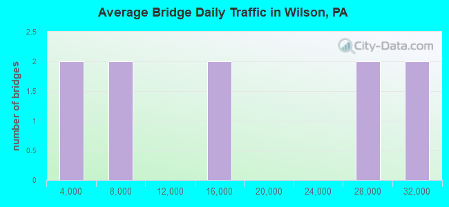
- 155,923Total average daily traffic
- 8,664Total average daily truck traffic
- National Bridge Inventory (NBI) Registered Bridges for Wilson
- No street view available for this location
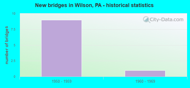
- New bridges - historical statistics
- 91950-1959
- 11960-1969
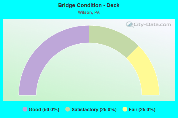
- Bridge Condition - Deck
- 50.0%Good
- 25.0%Satisfactory
- 25.0%Fair
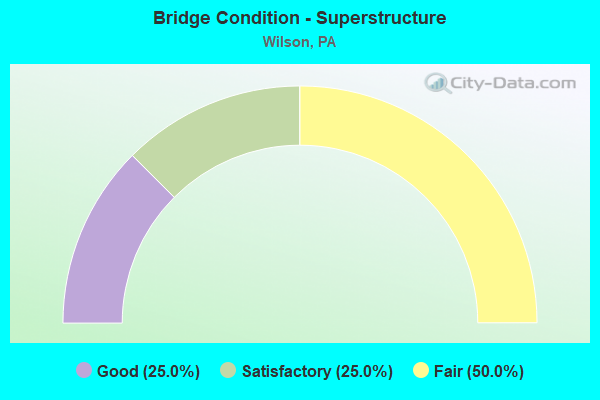
- Bridge Condition - Superstructure
- 25.0%Good
- 25.0%Satisfactory
- 50.0%Fair
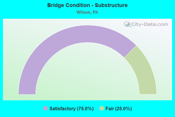
- Bridge Condition - Substructure
- 75.0%Satisfactory
- 25.0%Fair
Find on map >> Show street view
Structure Number: 28481, Location: 25TH ST.INTERCHANGE (Lat: 40.686300, Lng: -75.251764), Route carried "on" structure: US 22, Year Built: 1954, Year Reconstructed: 1985, Status: Open, Structure Length: 2.44m (8.01ft), Average Daily Traffic: 27,168 (year 2020), Truck Traffic: 6%, Average Future Daily Traffic: 59,100 (year 2032), Design Load: HS 20+Mod, Features Intersected: SR 2012(LR 48013)25TH ST
Minimum Vertical Clearance: 30+ m (98+ ft), Kilometerpoint: 14.510, Lanes on structure: 4, Lanes under structure: 8, Base Highway Network: Yes, Owner: State Highway Agency, Approaching Roadway Width: 20.7m (67.9ft), Skew: 33 degrees, Material/Design: Steel, Design/Construction: Stringer/Multi-beam, Number Of Spans In Main Unit: 1, Length of Maximum Span: 22.3m (73.2ft), Curb-To-Curb Width: 19.8m (65.0ft), Out-to-Out Width: 21.8m (71.5ft)
Condition: Deck: Good, Superstructure: Fair, Substructure: Fair, Operating Rating: 82.6 metric tons, Method Used To Determine Operating Rating: Load Factor (LF), Inventory Rating: 49.9 metric tons, Method Used To Determine Inventory Rating: Load Factor (LF), Structural Evaluation: Somewhat better than minimum adequacy, Deck Geometry: Equal to present minimum criteria, Underclear: Meets minimum limits, Approach Roadway Alignment: Better than present minimum criteria, Length Of Structure Improvement: 3.20m (10.50ft), Designated Inspection Frequency: Every 24 months, Other Special Inspection Frequency: Every 12 months, Inspection Date: August 2020, Other Special Inspection Date: August 2021, Bridge Improvement Cost: $33,000, Roadway Improvement Cost: $96,000, Total Project Cost: $442,000, Deck Structure Type: Concrete Cast-file-Place, Wearing Surface/Protective System: Wearing Surface: Monolithic Concrete, Deck Protection: Epoxy Coated Reinforcing
Find on map >> Show street view
Structure Number: 28482, Location: 25TH ST.INTERCHANGE (Lat: 40.687039, Lng: -75.251300), Route carried "on" structure: US 22, Year Built: 1954, Year Reconstructed: 1985, Status: Open, Structure Length: 2.53m (8.30ft), Average Daily Traffic: 27,168 (year 2020), Truck Traffic: 6%, Average Future Daily Traffic: 59,100 (year 2032), Design Load: HS 20, Features Intersected: SR 248 (LR 175)
Minimum Vertical Clearance: 30+ m (98+ ft), Kilometerpoint: 14.510, Lanes on structure: 4, Lanes under structure: 4, Base Highway Network: Yes, Owner: State Highway Agency, Approaching Roadway Width: 20.7m (67.9ft), Skew: 33 degrees, Material/Design: Steel, Design/Construction: Stringer/Multi-beam, Number Of Spans In Main Unit: 1, Length of Maximum Span: 23.5m (77.1ft), Curb-To-Curb Width: 19.8m (65.0ft), Out-to-Out Width: 21.8m (71.5ft)
Condition: Deck: Good, Superstructure: Good, Substructure: Satisfactory, Operating Rating: 88.0 metric tons, Method Used To Determine Operating Rating: Load Factor (LF), Inventory Rating: 52.6 metric tons, Method Used To Determine Inventory Rating: Load Factor (LF), Structural Evaluation: Equal to present minimum criteria, Deck Geometry: Equal to present minimum criteria, Underclear: High priority of corrective action, Approach Roadway Alignment: Equal to present desirable criteria, Length Of Structure Improvement: 3.30m (10.83ft), Designated Inspection Frequency: Every 24 months, Other Special Inspection Frequency: Every 12 months, Inspection Date: August 2020, Other Special Inspection Date: August 2021, Bridge Improvement Cost: $17,000, Roadway Improvement Cost: $49,000, Total Project Cost: $226,000, Deck Structure Type: Concrete Cast-file-Place, Wearing Surface/Protective System: Wearing Surface: Monolithic Concrete, Deck Protection: Epoxy Coated Reinforcing
Find on map >> Show street view
Structure Number: 28485, Location: 1 MI.E.OF 25TH ST EXIT (Lat: 40.694239, Lng: -75.238019), Route carried "on" structure: US 22, Year Built: 1954, Status: Open, Structure Length: 0.70m (2.30ft), Average Daily Traffic: 28,658 (year 2020), Truck Traffic: 6%, Average Future Daily Traffic: 55,694 (year 2032), Design Load: HS 20+Mod, Features Intersected: SPRING BROOK
Minimum Vertical Clearance: 30+ m (98+ ft), Kilometerpoint: 15.332, Lanes on structure: 4, Base Highway Network: Yes, Owner: State Highway Agency, Approaching Roadway Width: 20.7m (67.9ft), Skew: 34 degrees, Material/Design: Concrete, Design/Construction: Culvert, Number Of Spans In Main Unit: 1, Length of Maximum Span: 7.0m (23.0ft)
Condition: Channel: Fair, Culverts: Satisfactory, Inventory Rating: 68.0 metric tons, Method Used To Determine Inventory Rating: Load Factor (LF), Structural Evaluation: Equal to present minimum criteria, Waterway Adequacy: Superior to present desirable criteria, Approach Roadway Alignment: Equal to present desirable criteria, Length Of Structure Improvement: 1.30m (4.27ft), Designated Inspection Frequency: Every 24 months, Inspection Date: September 2021
Find on map >> Show street view
Structure Number: 28487, Location: 0.25 MI.W.OF 13 ST.EXIT (Lat: 40.694431, Lng: -75.235058), Route carried "on" structure: US 22, Year Built: 1954, Year Reconstructed: 1985, Status: Open, Structure Length: 7.59m (24.90ft), Average Daily Traffic: 28,658 (year 2020), Truck Traffic: 6%, Average Future Daily Traffic: 55,694 (year 2032), Design Load: HS 20, Features Intersected: SR2024,WOOD ST(48084),RR
Minimum Vertical Clearance: 30+ m (98+ ft), Kilometerpoint: 16.282, Lanes on structure: 4, Lanes under structure: 2, Base Highway Network: Yes, Owner: State Highway Agency, Approaching Roadway Width: 20.7m (67.9ft), Skew: 33 degrees, Material/Design: Steel continuous, Design/Construction: Stringer/Multi-beam, Number Of Spans In Main Unit: 3, Length of Maximum Span: 29.9m (98.1ft), Curb-To-Curb Width: 19.8m (65.0ft), Out-to-Out Width: 21.8m (71.5ft)
Condition: Deck: Satisfactory, Superstructure: Satisfactory, Substructure: Satisfactory, Operating Rating: 64.4 metric tons, Method Used To Determine Operating Rating: Load Factor (LF), Inventory Rating: 38.1 metric tons, Method Used To Determine Inventory Rating: Load Factor (LF), Structural Evaluation: Equal to present minimum criteria, Deck Geometry: Equal to present minimum criteria, Underclear: Somewhat better than minimum adequacy, Approach Roadway Alignment: Equal to present desirable criteria, Length Of Structure Improvement: 8.60m (28.22ft), Designated Inspection Frequency: Every 24 months, Other Special Inspection Frequency: Every 6 months, Inspection Date: August 2020, Other Special Inspection Date: August 2021, Deck Structure Type: Concrete Cast-file-Place, Wearing Surface/Protective System: Wearing Surface: Monolithic Concrete, Deck Protection: Epoxy Coated Reinforcing
Find on map >> Show street view
Structure Number: 28724, Location: S.25TH ST APPR.GLENDON BR (Lat: 40.667281, Lng: -75.240983), Route carried "on" structure: State highway , Year Built: 1969, Status: Open, Structure Length: 4.60m (15.09ft), Average Daily Traffic: 13,810 (year 2022), Truck Traffic: 5%, Average Future Daily Traffic: 18,474 (year 2032), Design Load: HS 20, Features Intersected: C.R.R. OF NJ (REMOVED), Facility Carried by Structure: SR 2012 (LR 48013)
Minimum Vertical Clearance: 30+ m (98+ ft), Kilometerpoint: 11.608, Lanes on structure: 4, Owner: State Highway Agency, Approaching Roadway Width: 21.3m (69.9ft), Skew: 31 degrees, Material/Design: Prestressed concrete, Design/Construction: Box Beam or Girders - Single/Spread, Number Of Spans In Main Unit: 3, Length of Maximum Span: 15.5m (50.9ft), Curb-To-Curb Width: 21.3m (69.9ft), Out-to-Out Width: 23.2m (76.1ft)
Condition: Deck: Fair, Superstructure: Fair, Substructure: Satisfactory, Operating Rating: 78.9 metric tons, Method Used To Determine Operating Rating: Load Factor (LF), Inventory Rating: 28.1 metric tons, Method Used To Determine Inventory Rating: Load Factor (LF), Structural Evaluation: Somewhat better than minimum adequacy, Deck Geometry: Superior to present desirable criteria, Approach Roadway Alignment: Equal to present desirable criteria, Length Of Structure Improvement: 5.50m (18.04ft), Designated Inspection Frequency: Every 24 months, Inspection Date: July 2021, Deck Structure Type: Concrete Cast-file-Place, Wearing Surface/Protective System: Wearing Surface: Monolithic Concrete
Find on map >> Show street view
Structure Number: 28481, Location: 25TH ST.INTERCHANGE (Lat: 40.686300, Lng: -75.251764), Route carried "under" structure: State highway , Year Built: 1954, Structure Length: 0. m, Average Daily Traffic: 12,706 (year 2022), Truck Traffic: 4%, Features Intersected: SR 2012(LR 48013)25TH ST, Facility Carried by Structure: US 22(LR 773)
Minimum Vertical Clearance: 4.34m (14.24ft), Kilometerpoint: 14.259, Lanes on structure: 4, Lanes under structure: 4, Material/Design: Steel, Design/Construction: Stringer/Multi-beam, Length of Maximum Span: 22.3m (73.2ft)
Find on map >> Show street view
Structure Number: 28481, Location: 25TH ST.INTERCHANGE (Lat: 40.686300, Lng: -75.251764), Route carried "under" structure: State highway , Year Built: 1954, Structure Length: 0. m, Average Daily Traffic: 6,706 (year 2020), Truck Traffic: 4%, Features Intersected: SR 2012(LR 48013)25TH ST, Facility Carried by Structure: US 22(LR 773)
Minimum Vertical Clearance: 30+ m (98+ ft), Kilometerpoint: 14.259, Lanes on structure: 4, Lanes under structure: 4, Material/Design: Steel, Design/Construction: Stringer/Multi-beam, Length of Maximum Span: 22.3m (73.2ft)
Find on map >> Show street view
Structure Number: 28482, Location: 25TH ST.INTERCHANGE (Lat: 40.687039, Lng: -75.251300), Route carried "under" structure: State highway 248, Year Built: 1954, Structure Length: 0. m, Average Daily Traffic: 3,368 (year 2021), Truck Traffic: 4%, Features Intersected: SR 248 (LR 175), Facility Carried by Structure: SR 22 (LR 773)
Minimum Vertical Clearance: 4.54m (14.90ft), Kilometerpoint: 34.590, Lanes on structure: 4, Lanes under structure: 2, Material/Design: Steel, Design/Construction: Stringer/Multi-beam, Length of Maximum Span: 23.5m (77.1ft)
Find on map >> Show street view
Structure Number: 28482, Location: 25TH ST.INTERCHANGE (Lat: 40.687039, Lng: -75.251300), Route carried "under" structure: State highway 248, Year Built: 1954, Structure Length: 0. m, Average Daily Traffic: 3,119 (year 2021), Truck Traffic: 3%, Features Intersected: SR 248 (LR 175), Facility Carried by Structure: SR 22 (LR 773)
Minimum Vertical Clearance: 4.75m (15.58ft), Kilometerpoint: 34.585, Lanes on structure: 4, Lanes under structure: 2, Material/Design: Steel, Design/Construction: Stringer/Multi-beam, Length of Maximum Span: 23.5m (77.1ft)
Find on map >> Show street view
Structure Number: 28487, Location: 0.25 MI.W.OF 13 ST.EXIT (Lat: 40.694431, Lng: -75.235058), Route carried "under" structure: State highway , Year Built: 1954, Structure Length: 0. m, Average Daily Traffic: 4,562 (year 2022), Truck Traffic: 6%, Features Intersected: SR2024,WOOD ST(48084),RR, Facility Carried by Structure: SR 22 (LR 773)
Minimum Vertical Clearance: 6.58m (21.59ft), Kilometerpoint: 1.579, Lanes on structure: 4, Lanes under structure: 2, Material/Design: Steel continuous, Design/Construction: Stringer/Multi-beam, Length of Maximum Span: 29.9m (98.1ft)