Bridge Statistics for Wilsonville, Nebraska (NE)
Condition, Traffic, Stress, Structural Evaluation, Project Costs
- National Bridge Inventory (NBI) Statistics
- 10Number of bridges
- 43ft / 13.3mTotal length
- 3,310Total average daily traffic
- 539Total average daily truck traffic
- 4,378Total future (year 2033) average daily traffic
- National Bridge Inventory (NBI) Registered Bridges for Wilsonville
- No street view available for this location
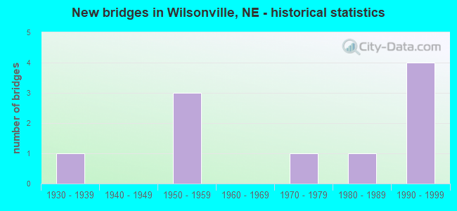
- New bridges - historical statistics
- 11930-1939
- 31950-1959
- 11970-1979
- 11980-1989
- 41990-1999

- Bridge Condition - Deck
- 40.0%Very good
- 40.0%Good
- 20.0%Satisfactory

- Bridge Condition - Superstructure
- 40.0%Very good
- 40.0%Good
- 20.0%Satisfactory

- Bridge Condition - Substructure
- 60.0%Very good
- 40.0%Satisfactory

- Bridge Condition - Channel
- 30.0%Excellent
- 50.0%Very good
- 20.0%Fair
Find on map >> Show street view
Structure Number: C00330071, Location: 1S 1.5W OF WILSONVILLE (Lat: 40.098300, Lng: -100.136700), Route carried "on" structure: County highway 7, Year Built: 1935, Status: Posted for load, Structure Length: 1.25m (4.10ft), Average Daily Traffic: 15 (year 2003), Average Future Daily Traffic: 25 (year 2033), Features Intersected: BEAVER CREEK, Facility Carried by Structure: COUNTY HIGHWAY
Minimum Vertical Clearance: 30+ m (98+ ft), Kilometerpoint: 0.000, Lanes on structure: 2, Owner: County Highway Agency, Approaching Roadway Width: 6.7m (22.0ft), Skew: 3 degrees, Material/Design: Steel, Design/Construction: Stringer/Multi-beam, Number Of Spans In Main Unit: 2, Length of Maximum Span: 8.5m (27.9ft), Curb-To-Curb Width: 7.2m (23.6ft), Out-to-Out Width: 7.3m (24.0ft)
Condition: Deck: Satisfactory, Superstructure: Satisfactory, Substructure: Satisfactory, Channel: Fair, Operating Rating: 33.0 metric tons, Method Used To Determine Operating Rating: Load Factor (LF), Inventory Rating: 20.0 metric tons, Method Used To Determine Inventory Rating: Load Factor (LF), Structural Evaluation: Somewhat better than minimum adequacy, Deck Geometry: Somewhat better than minimum adequacy, Waterway Adequacy: Meets minimum limits, Approach Roadway Alignment: Equal to present desirable criteria, Bridge Posting: Required (Relationship of Operating Rating to Maximum Legal Load: 10.0 - 19.9% below), Designated Inspection Frequency: Every 24 months, Inspection Date: October 2020, Deck Structure Type: Steel plate, Wearing Surface/Protective System: Wearing Surface: Gravel
Find on map >> Show street view
Structure Number: C003300915P, Location: .5S OF WILSONVILLE (Lat: 40.101700, Lng: -100.108300), Route carried "on" structure: County highway P9, Year Built: 1987, Status: Open, Structure Length: 2.74m (8.99ft), Average Daily Traffic: 60 (year 2003), Average Future Daily Traffic: 102 (year 2042), Features Intersected: BEAVER CREEK, Facility Carried by Structure: COUNTY HIGHWAY
Minimum Vertical Clearance: 30+ m (98+ ft), Kilometerpoint: 0.000, Lanes on structure: 2, Owner: County Highway Agency, Approaching Roadway Width: 8.5m (27.9ft), Material/Design: Prestressed concrete, Design/Construction: Tee Beam, Number Of Spans In Main Unit: 3, Length of Maximum Span: 9.1m (29.9ft), Curb-To-Curb Width: 8.6m (28.2ft), Out-to-Out Width: 9.2m (30.2ft)
Condition: Deck: Very good, Superstructure: Very good, Substructure: Very good, Channel: Very good, Operating Rating: 65.0 metric tons, Method Used To Determine Operating Rating: Load Factor (LF), Inventory Rating: 39.0 metric tons, Method Used To Determine Inventory Rating: Load Factor (LF), Structural Evaluation: Equal to present desirable criteria, Deck Geometry: Better than present minimum criteria, Waterway Adequacy: Superior to present desirable criteria, Approach Roadway Alignment: Equal to present desirable criteria, Designated Inspection Frequency: Every 24 months, Inspection Date: October 2021, Deck Structure Type: Concrete Cast-file-Place, Wearing Surface/Protective System: Wearing Surface: Monolithic Concrete
Find on map >> Show street view
Structure Number: C00330111, Location: JCT N47/89 3E .3S (Lat: 40.099700, Lng: -100.098800), Route carried "on" structure: County highway 1635, Year Built: 1973, Status: Posted for load, Structure Length: 1.28m (4.20ft), Average Daily Traffic: 115 (year 2011), Average Future Daily Traffic: 115 (year 2042), Features Intersected: BEAVER CREEK
Minimum Vertical Clearance: 30+ m (98+ ft), Kilometerpoint: 0.113, Lanes on structure: 2, Owner: County Highway Agency, Approaching Roadway Width: 9.1m (29.9ft), Material/Design: Steel, Design/Construction: Stringer/Multi-beam, Number Of Spans In Main Unit: 1, Length of Maximum Span: 11.9m (39.0ft), Curb-To-Curb Width: 7.9m (25.9ft), Out-to-Out Width: 7.9m (25.9ft)
Condition: Deck: Good, Superstructure: Good, Substructure: Satisfactory, Channel: Fair, Operating Rating: 32.0 metric tons, Method Used To Determine Operating Rating: Load Factor (LF), Inventory Rating: 19.0 metric tons, Method Used To Determine Inventory Rating: Load Factor (LF), Structural Evaluation: Somewhat better than minimum adequacy, Deck Geometry: Somewhat better than minimum adequacy, Waterway Adequacy: Meets minimum limits, Approach Roadway Alignment: Equal to present minimum criteria, Bridge Posting: Required (Relationship of Operating Rating to Maximum Legal Load: 10.0 - 19.9% below), Length Of Structure Improvement: 1.28m (4.20ft), Designated Inspection Frequency: Every 24 months, Inspection Date: October 2021, Deck Structure Type: Concrete Cast-file-Place, Wearing Surface/Protective System: Wearing Surface: Monolithic Concrete
Find on map >> Show street view
Structure Number: S089 02352, Location: 3W WILSONVILLE (Lat: 40.103000, Lng: -100.161200), Route carried "on" structure: State highway 89, Year Built: 1957, Year Reconstructed: 1996, Status: Open, Structure Length: 0.79m (2.59ft), Average Daily Traffic: 225 (year 2018), Truck Traffic: 13%, Average Future Daily Traffic: 293 (year 2038), Design Load: H 15, Features Intersected: BEAVER CREEK TRIBUTARY
Minimum Vertical Clearance: 30+ m (98+ ft), Kilometerpoint: 3.785, Lanes on structure: 2, Base Highway Network: Yes, Owner: State Highway Agency, Approaching Roadway Width: 7.3m (24.0ft), Material/Design: Concrete, Design/Construction: Culvert, Number Of Spans In Main Unit: 2, Length of Maximum Span: 3.7m (12.1ft)
Condition: Channel: Very good, Culverts: Very good, Operating Rating: 33.0 metric tons, Method Used To Determine Operating Rating: Field evaluation and documented engineering judgment, Inventory Rating: 22.0 metric tons, Method Used To Determine Inventory Rating: Field evaluation and documented engineering judgment, Structural Evaluation: Equal to present minimum criteria, Waterway Adequacy: Equal to present desirable criteria, Approach Roadway Alignment: Equal to present desirable criteria, Designated Inspection Frequency: Every 24 months, Inspection Date: April 2021
Find on map >> Show street view
Structure Number: S089 02449, Location: 2W WILSONVILLE (Lat: 40.105800, Lng: -100.143400), Route carried "on" structure: State highway 89, Year Built: 1998, Status: Open, Structure Length: 1.43m (4.69ft), Average Daily Traffic: 510 (year 2018), Truck Traffic: 20%, Average Future Daily Traffic: 689 (year 2038), Design Load: HS 20, Features Intersected: BEAVER CREEK TRIBUTARY
Minimum Vertical Clearance: 30+ m (98+ ft), Kilometerpoint: 3.941, Lanes on structure: 2, Base Highway Network: Yes, Owner: State Highway Agency, Approaching Roadway Width: 7.3m (24.0ft), Skew: 3 degrees, Material/Design: Concrete, Design/Construction: Culvert, Number Of Spans In Main Unit: 3, Length of Maximum Span: 4.0m (13.1ft)
Condition: Channel: Very good, Culverts: Very good, Operating Rating: 43.0 metric tons, Method Used To Determine Operating Rating: Field evaluation and documented engineering judgment, Inventory Rating: 33.0 metric tons, Method Used To Determine Inventory Rating: Field evaluation and documented engineering judgment, Structural Evaluation: Equal to present desirable criteria, Waterway Adequacy: Equal to present desirable criteria, Approach Roadway Alignment: Equal to present desirable criteria, Designated Inspection Frequency: Every 24 months, Inspection Date: April 2021
Find on map >> Show street view
Structure Number: S089 02526, Location: 1W WILSONVILLE (Lat: 40.108100, Lng: -100.129100), Route carried "on" structure: State highway 89, Year Built: 1957, Year Reconstructed: 1998, Status: Open, Structure Length: 0.79m (2.59ft), Average Daily Traffic: 510 (year 2018), Truck Traffic: 20%, Average Future Daily Traffic: 689 (year 2038), Design Load: H 15, Features Intersected: BEAVER CREEK TRIBUTARY
Minimum Vertical Clearance: 30+ m (98+ ft), Kilometerpoint: 4.065, Lanes on structure: 2, Base Highway Network: Yes, Owner: State Highway Agency, Approaching Roadway Width: 7.3m (24.0ft), Material/Design: Concrete, Design/Construction: Culvert, Number Of Spans In Main Unit: 2, Length of Maximum Span: 3.7m (12.1ft)
Condition: Channel: Very good, Culverts: Very good, Operating Rating: 33.0 metric tons, Method Used To Determine Operating Rating: Field evaluation and documented engineering judgment, Inventory Rating: 22.0 metric tons, Method Used To Determine Inventory Rating: Field evaluation and documented engineering judgment, Structural Evaluation: Somewhat better than minimum adequacy, Waterway Adequacy: Equal to present desirable criteria, Approach Roadway Alignment: Equal to present desirable criteria, Designated Inspection Frequency: Every 24 months, Inspection Date: April 2021
Find on map >> Show street view
Structure Number: S089 02595, Location: 1W WILSONVILLE (Lat: 40.109100, Lng: -100.116400), Route carried "on" structure: State highway 89, Year Built: 1998, Status: Open, Structure Length: 1.58m (5.18ft), Average Daily Traffic: 510 (year 2018), Truck Traffic: 20%, Average Future Daily Traffic: 689 (year 2038), Design Load: HS 20, Features Intersected: BEAVER CREEK TRIBUTARY
Minimum Vertical Clearance: 30+ m (98+ ft), Kilometerpoint: 4.176, Lanes on structure: 2, Base Highway Network: Yes, Owner: State Highway Agency, Approaching Roadway Width: 7.3m (24.0ft), Material/Design: Prestressed concrete, Design/Construction: Tee Beam, Number Of Spans In Main Unit: 1, Length of Maximum Span: 15.2m (49.9ft), Curb-To-Curb Width: 10.8m (35.4ft), Out-to-Out Width: 11.5m (37.7ft)
Condition: Deck: Very good, Superstructure: Very good, Substructure: Very good, Channel: Excellent, Operating Rating: 74.0 metric tons, Method Used To Determine Operating Rating: Load Factor (LF), Inventory Rating: 44.0 metric tons, Method Used To Determine Inventory Rating: Load Factor (LF), Structural Evaluation: Equal to present desirable criteria, Deck Geometry: Equal to present minimum criteria, Waterway Adequacy: Equal to present desirable criteria, Approach Roadway Alignment: Equal to present desirable criteria, Designated Inspection Frequency: Every 24 months, Inspection Date: April 2021, Deck Structure Type: Concrete Cast-file-Place, Wearing Surface/Protective System: Wearing Surface: Monolithic Concrete, Deck Protection: Epoxy Coated Reinforcing
Find on map >> Show street view
Structure Number: S089 02691, Location: 0E WILSONVILLE (Lat: 40.109800, Lng: -100.098800), Route carried "on" structure: State highway 89, Year Built: 1998, Status: Open, Structure Length: 0.82m (2.69ft), Average Daily Traffic: 455 (year 2018), Truck Traffic: 15%, Average Future Daily Traffic: 592 (year 2038), Design Load: HS 20, Features Intersected: BEAVER CREEK TRIBUTARY
Minimum Vertical Clearance: 30+ m (98+ ft), Kilometerpoint: 4.331, Lanes on structure: 2, Base Highway Network: Yes, Owner: State Highway Agency, Approaching Roadway Width: 7.3m (24.0ft), Skew: 3 degrees, Material/Design: Concrete, Design/Construction: Culvert, Number Of Spans In Main Unit: 2, Length of Maximum Span: 4.0m (13.1ft)
Condition: Channel: Excellent, Culverts: Very good, Operating Rating: 33.0 metric tons, Method Used To Determine Operating Rating: Field evaluation and documented engineering judgment, Inventory Rating: 22.0 metric tons, Method Used To Determine Inventory Rating: Field evaluation and documented engineering judgment, Structural Evaluation: Equal to present minimum criteria, Waterway Adequacy: Superior to present desirable criteria, Approach Roadway Alignment: Equal to present desirable criteria, Designated Inspection Frequency: Every 24 months, Inspection Date: April 2021
Find on map >> Show street view
Structure Number: S089 02709, Location: 1E WILSONVILLE (Lat: 40.110400, Lng: -100.095300), Route carried "on" structure: State highway 89, Year Built: 1953, Year Reconstructed: 1998, Status: Open, Structure Length: 0.94m (3.08ft), Average Daily Traffic: 455 (year 2018), Truck Traffic: 15%, Average Future Daily Traffic: 592 (year 2038), Design Load: HS 25 or greater, Features Intersected: BEAVER CREEK TRIBUTARY
Minimum Vertical Clearance: 30+ m (98+ ft), Kilometerpoint: 4.360, Lanes on structure: 2, Base Highway Network: Yes, Owner: State Highway Agency, Approaching Roadway Width: 7.3m (24.0ft), Material/Design: Prestressed concrete, Design/Construction: Tee Beam, Number Of Spans In Main Unit: 1, Length of Maximum Span: 8.8m (28.9ft), Curb-To-Curb Width: 10.8m (35.4ft), Out-to-Out Width: 11.5m (37.7ft)
Condition: Deck: Good, Superstructure: Good, Substructure: Very good, Channel: Very good, Operating Rating: 83.0 metric tons, Method Used To Determine Operating Rating: Load Factor (LF), Inventory Rating: 50.0 metric tons, Method Used To Determine Inventory Rating: Load Factor (LF), Structural Evaluation: Better than present minimum criteria, Deck Geometry: Equal to present minimum criteria, Waterway Adequacy: Superior to present desirable criteria, Approach Roadway Alignment: Equal to present desirable criteria, Designated Inspection Frequency: Every 24 months, Inspection Date: April 2021, Deck Structure Type: Concrete Cast-file-Place, Wearing Surface/Protective System: Wearing Surface: Monolithic Concrete
Find on map >> Show street view
Structure Number: S089 02831, Location: 2E WILSONVILLE (Lat: 40.110600, Lng: -100.072400), Route carried "on" structure: State highway 89, Year Built: 1998, Status: Open, Structure Length: 1.68m (5.51ft), Average Daily Traffic: 455 (year 2018), Truck Traffic: 15%, Average Future Daily Traffic: 592 (year 2038), Design Load: HS 20, Features Intersected: STREAM
Minimum Vertical Clearance: 30+ m (98+ ft), Kilometerpoint: 4.556, Lanes on structure: 2, Base Highway Network: Yes, Owner: State Highway Agency, Approaching Roadway Width: 7.3m (24.0ft), Material/Design: Concrete, Design/Construction: Culvert, Number Of Spans In Main Unit: 4, Length of Maximum Span: 4.0m (13.1ft)
Condition: Channel: Excellent, Culverts: Very good, Operating Rating: 43.0 metric tons, Method Used To Determine Operating Rating: Field evaluation and documented engineering judgment, Inventory Rating: 33.0 metric tons, Method Used To Determine Inventory Rating: Field evaluation and documented engineering judgment, Structural Evaluation: Equal to present desirable criteria, Waterway Adequacy: Superior to present desirable criteria, Approach Roadway Alignment: Equal to present desirable criteria, Designated Inspection Frequency: Every 48 months, Inspection Date: April 2021