Bridge Statistics for Wilton, Maine (ME)
Condition, Traffic, Stress, Structural Evaluation, Project Costs
- National Bridge Inventory (NBI) Statistics
- 15Number of bridges
- 52ft / 15.9mTotal length
- 58,792Total average daily traffic
- 4,030Total average daily truck traffic
- National Bridge Inventory (NBI) Registered Bridges for Wilton
- No street view available for this location
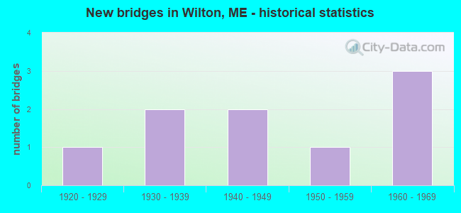
- New bridges - historical statistics
- 11920-1929
- 21930-1939
- 21940-1949
- 11950-1959
- 31960-1969

- Reconstructed bridges - Historical Statistics
- 11960-1969
- 01970-1979
- 01980-1989
- 01990-1999
- 12000-2009
- 12010-2019


- Bridge Condition - Deck
- 12.5%Excellent
- 12.5%Very good
- 12.5%Good
- 12.5%Satisfactory
- 37.5%Fair
- 12.5%Poor

- Bridge Condition - Superstructure
- 37.5%Good
- 12.5%Satisfactory
- 37.5%Fair
- 12.5%Poor

- Bridge Condition - Substructure
- 12.5%Good
- 62.5%Satisfactory
- 25.0%Fair

- Bridge Condition - Channel
- 33.3%Good
- 33.3%Satisfactory
- 22.2%Fair
- 11.1%Poor
Find on map >> Show street view
Structure Number: 2116, Location: .6 MI S JCT US 2 (Lat: 44.613381, Lng: -70.173761), Route carried "on" structure: City street , Year Built: 1938, Status: Open, Structure Length: 1.90m (6.23ft), Average Daily Traffic: 649 (year 2016), Truck Traffic: 5%, Average Future Daily Traffic: 1,038 (year 2036), Design Load: H 15, Features Intersected: WILSON STREAM, Facility Carried by Structure: MCQUILLIS CORNER R
Minimum Vertical Clearance: 30+ m (98+ ft), Kilometerpoint: 1.159, Lanes on structure: 2, Owner: State Highway Agency, Approaching Roadway Width: 7.0m (23.0ft), Material/Design: Steel, Design/Construction: Stringer/Multi-beam, Number Of Spans In Main Unit: 1, Length of Maximum Span: 18.3m (60.0ft), Curb or Sidewalk Widths: Left: 0.1m (0.3ft), Right: 0.1m (0.3ft), Curb-To-Curb Width: 6.7m (22.0ft), Out-to-Out Width: 7.8m (25.6ft)
Condition: Deck: Fair, Superstructure: Good, Substructure: Satisfactory, Channel: Satisfactory, Operating Rating: 32.4 metric tons, Method Used To Determine Operating Rating: Load and Resistance Factor Rating (LRFR) rating reported by rating factor(RF) method using HL-93 loadings, Inventory Rating: 24.9 metric tons, Method Used To Determine Inventory Rating: Load and Resistance Factor Rating (LRFR) rating reported by rating factor(RF) method using HL-93 loadings, Structural Evaluation: Equal to present minimum criteria, Deck Geometry: Meets minimum limits, Waterway Adequacy: Equal to present desirable criteria, Approach Roadway Alignment: Equal to present minimum criteria, Designated Inspection Frequency: Every 24 months, Inspection Date: August 2021, Deck Structure Type: Concrete Cast-file-Place, Wearing Surface/Protective System: Wearing Surface: Latex Concrete
Find on map >> Show street view
Structure Number: 2336, Location: AT JCT OF PROSPECT STREET (Lat: 44.586631, Lng: -70.231631), Route carried "on" structure: County highway , Year Built: 1958, Status: Open, Structure Length: 1.85m (6.07ft), Average Daily Traffic: 2,854 (year 2016), Truck Traffic: 5%, Average Future Daily Traffic: 3,996 (year 2036), Design Load: HS 20, Features Intersected: WILSON STREAM, Facility Carried by Structure: MAIN ST(OLD RTE 4)
Minimum Vertical Clearance: 30+ m (98+ ft), Kilometerpoint: 0.676, Lanes on structure: 2, Owner: State Highway Agency, Approaching Roadway Width: 12.2m (40.0ft), Skew: 2 degrees, Material/Design: Concrete, Design/Construction: Tee Beam, Number Of Spans In Main Unit: 2, Length of Maximum Span: 8.5m (27.9ft), Curb or Sidewalk Widths: Left: 1.2m (3.9ft), Right: 1.2m (3.9ft), Curb-To-Curb Width: 18.3m (60.0ft), Out-to-Out Width: 21.3m (69.9ft)
Condition: Deck: Fair, Superstructure: Fair, Substructure: Fair, Channel: Fair, Operating Rating: 42.8 metric tons, Method Used To Determine Operating Rating: Load and Resistance Factor Rating (LRFR) rating reported by rating factor(RF) method using HL-93 loadings, Inventory Rating: 33.0 metric tons, Method Used To Determine Inventory Rating: Load and Resistance Factor Rating (LRFR) rating reported by rating factor(RF) method using HL-93 loadings, Structural Evaluation: Somewhat better than minimum adequacy, Deck Geometry: Superior to present desirable criteria, Waterway Adequacy: Superior to present desirable criteria, Approach Roadway Alignment: Equal to present minimum criteria, Designated Inspection Frequency: Every 24 months, Inspection Date: May 2021, Deck Structure Type: Concrete Cast-file-Place, Wearing Surface/Protective System: Wearing Surface: Bituminous
Find on map >> Show street view
Structure Number: 2341, Location: 0.1 MI W'LY JCT RTE 17 (Lat: 44.572769, Lng: -70.301031), Route carried "on" structure: State highway 2, Year Built: 1932, Year Reconstructed: 1972, Status: Open, Structure Length: 0.72m (2.36ft), Average Daily Traffic: 3,892 (year 2016), Truck Traffic: 5%, Average Future Daily Traffic: 5,449 (year 2036), Design Load: HS 20, Features Intersected: HOOPER(BUTTERFIELD) BRK.
Minimum Vertical Clearance: 30+ m (98+ ft), Kilometerpoint: 84.426, Lanes on structure: 2, Base Highway Network: Yes, Owner: State Highway Agency, Approaching Roadway Width: 13.4m (44.0ft), Material/Design: Concrete, Design/Construction: Slab, Number Of Spans In Main Unit: 1, Length of Maximum Span: 6.1m (20.0ft), Curb-To-Curb Width: 13.4m (44.0ft), Out-to-Out Width: 14.3m (46.9ft)
Condition: Deck: Poor, Superstructure: Poor, Substructure: Fair, Channel: Fair, Operating Rating: 33.0 metric tons, Method Used To Determine Operating Rating: Load and Resistance Factor Rating (LRFR) rating reported by rating factor(RF) method using HL-93 loadings, Inventory Rating: 25.6 metric tons, Method Used To Determine Inventory Rating: Load and Resistance Factor Rating (LRFR) rating reported by rating factor(RF) method using HL-93 loadings, Structural Evaluation: Meets minimum limits, Deck Geometry: Better than present minimum criteria, Waterway Adequacy: Better than present minimum criteria, Approach Roadway Alignment: Equal to present desirable criteria, Designated Inspection Frequency: Every 24 months, Inspection Date: October 2021, Deck Structure Type: Concrete Cast-file-Place, Wearing Surface/Protective System: Wearing Surface: Integral Concrete
Find on map >> Show street view
Structure Number: 2484, Location: 0.6 MI W JCT US 2 (Lat: 44.590169, Lng: -70.219319), Route carried "on" structure: County highway 156, Year Built: 1928, Status: Open, Structure Length: 1.16m (3.81ft), Average Daily Traffic: 2,942 (year 2016), Truck Traffic: 5%, Average Future Daily Traffic: 4,119 (year 2036), Design Load: H 15, Features Intersected: WILSON STREAM
Minimum Vertical Clearance: 30+ m (98+ ft), Kilometerpoint: 14.742, Lanes on structure: 2, Owner: State Highway Agency, Approaching Roadway Width: 7.9m (25.9ft), Skew: 2 degrees, Material/Design: Concrete, Design/Construction: Tee Beam, Number Of Spans In Main Unit: 1, Length of Maximum Span: 9.1m (29.9ft), Curb or Sidewalk Widths: Left: 0.0m, Right: 1.5m (4.9ft), Curb-To-Curb Width: 7.9m (25.9ft), Out-to-Out Width: 10.4m (34.1ft)
Condition: Deck: Fair, Superstructure: Fair, Substructure: Satisfactory, Channel: Satisfactory, Operating Rating: 14.3 metric tons, Method Used To Determine Operating Rating: Load and Resistance Factor Rating (LRFR) rating reported by rating factor(RF) method using HL-93 loadings, Inventory Rating: 11.0 metric tons, Method Used To Determine Inventory Rating: Load and Resistance Factor Rating (LRFR) rating reported by rating factor(RF) method using HL-93 loadings, Structural Evaluation: High priority of corrective action, Deck Geometry: High priority of corrective action, Waterway Adequacy: Equal to present desirable criteria, Approach Roadway Alignment: Equal to present desirable criteria, Designated Inspection Frequency: Every 24 months, Inspection Date: October 2021, Deck Structure Type: Concrete Cast-file-Place, Wearing Surface/Protective System: Wearing Surface: Bituminous
Find on map >> Show street view
Structure Number: 3732, Location: 0.1 MI S RTE 2 (Lat: 44.572681, Lng: -70.305300), Route carried "on" structure: City street , Year Built: 1940, Year Reconstructed: 2000, Status: Open, Structure Length: 1.43m (4.69ft), Average Daily Traffic: 39 (year 2016), Truck Traffic: 5%, Average Future Daily Traffic: 62 (year 2036), Design Load: HS 25 or greater, Features Intersected: SEVEN MILE STREAM, Facility Carried by Structure: CHURCH STREET
Minimum Vertical Clearance: 30+ m (98+ ft), Kilometerpoint: 0.145, Lanes on structure: 1, Owner: Town or Township Highway Agency, Approaching Roadway Width: 4.3m (14.1ft), Material/Design: Wood or Timber, Design/Construction: Stringer/Multi-beam, Number Of Spans In Main Unit: 1, Length of Maximum Span: 13.7m (44.9ft), Curb-To-Curb Width: 4.0m (13.1ft), Out-to-Out Width: 4.8m (15.7ft)
Condition: Deck: Good, Superstructure: Good, Substructure: Satisfactory, Channel: Good, Operating Rating: 54.4 metric tons, Method Used To Determine Operating Rating: Load and Resistance Factor Rating (LRFR) rating reported by rating factor(RF) method using HL-93 loadings, Inventory Rating: 42.1 metric tons, Method Used To Determine Inventory Rating: Load and Resistance Factor Rating (LRFR) rating reported by rating factor(RF) method using HL-93 loadings, Structural Evaluation: Equal to present minimum criteria, Deck Geometry: Somewhat better than minimum adequacy, Waterway Adequacy: Equal to present desirable criteria, Approach Roadway Alignment: Equal to present minimum criteria, Designated Inspection Frequency: Every 24 months, Inspection Date: October 2021, Deck Structure Type: Wood or Timber, Wearing Surface/Protective System: Wearing Surface: Bituminous, Membrane: Preformed Fabric
Find on map >> Show street view
Structure Number: 5255, Location: 0.1 MI S OF JCT RTE 17 (Lat: 44.564189, Lng: -70.287400), Route carried "on" structure: City street , Year Built: 1949, Status: Open, Structure Length: 2.28m (7.48ft), Average Daily Traffic: 188 (year 2016), Truck Traffic: 5%, Average Future Daily Traffic: 301 (year 2036), Design Load: H 15, Features Intersected: SEVEN MILE STREAM, Facility Carried by Structure: SEVERY HILL ROAD
Minimum Vertical Clearance: 30+ m (98+ ft), Kilometerpoint: 0.000, Lanes on structure: 1, Owner: State Highway Agency, Approaching Roadway Width: 7.3m (24.0ft), Material/Design: Steel, Design/Construction: Girder and Floorbeam System, Number Of Spans In Main Unit: 1, Length of Maximum Span: 21.3m (69.9ft), Curb or Sidewalk Widths: Left: 0.2m (0.7ft), Right: 0.2m (0.7ft), Curb-To-Curb Width: 4.3m (14.1ft), Out-to-Out Width: 5.1m (16.7ft)
Condition: Deck: Very good, Superstructure: Satisfactory, Substructure: Satisfactory, Channel: Satisfactory, Operating Rating: 35.3 metric tons, Method Used To Determine Operating Rating: Load and Resistance Factor Rating (LRFR) rating reported by rating factor(RF) method using HL-93 loadings, Inventory Rating: 27.2 metric tons, Method Used To Determine Inventory Rating: Load and Resistance Factor Rating (LRFR) rating reported by rating factor(RF) method using HL-93 loadings, Structural Evaluation: Equal to present minimum criteria, Deck Geometry: High priority of replacement, Waterway Adequacy: Superior to present desirable criteria, Approach Roadway Alignment: Equal to present minimum criteria, Designated Inspection Frequency: Every 24 months, Critical Feature Inspection Frequency: Every 24 months, Inspection Date: July 2020, Critical Feature Inspection Date: July 2020, Deck Structure Type: Open Grating
Find on map >> Show street view
Structure Number: 5367, Location: 1.5 MI E TOWNLINE (Lat: 44.633339, Lng: -70.290989), Route carried "on" structure: County highway 156, Year Built: 1961, Status: Open, Structure Length: 1.09m (3.58ft), Average Daily Traffic: 935 (year 2016), Truck Traffic: 5%, Average Future Daily Traffic: 1,496 (year 2036), Design Load: HS 20, Features Intersected: TEMPLE BROOK
Minimum Vertical Clearance: 30+ m (98+ ft), Kilometerpoint: 22.370, Lanes on structure: 2, Owner: State Highway Agency, Approaching Roadway Width: 7.3m (24.0ft), Material/Design: Concrete, Design/Construction: Culvert, Number Of Spans In Main Unit: 1, Length of Maximum Span: 9.8m (32.2ft)
Condition: Channel: Poor, Culverts: Fair, Operating Rating: 48.6 metric tons, Method Used To Determine Operating Rating: Load and Resistance Factor Rating (LRFR) rating reported by rating factor(RF) method using HL-93 loadings, Inventory Rating: 37.6 metric tons, Method Used To Determine Inventory Rating: Load and Resistance Factor Rating (LRFR) rating reported by rating factor(RF) method using HL-93 loadings, Structural Evaluation: Somewhat better than minimum adequacy, Waterway Adequacy: Equal to present desirable criteria, Approach Roadway Alignment: Better than present minimum criteria, Designated Inspection Frequency: Every 24 months, Inspection Date: November 2020
Find on map >> Show street view
Structure Number: 5936, Location: 1.2 MI W OF FARMINGTON (Lat: 44.614761, Lng: -70.186081), Route carried "on" structure: State highway 2, Year Built: 1962, Year Reconstructed: 2019, Status: Open, Structure Length: 3.88m (12.73ft), Average Daily Traffic: 9,341 (year 2016), Truck Traffic: 5%, Average Future Daily Traffic: 13,077 (year 2036), Design Load: HL 93, Features Intersected: WILSON STREAM
Minimum Vertical Clearance: 30+ m (98+ ft), Kilometerpoint: 97.896, Lanes on structure: 2, Base Highway Network: Yes, Owner: State Highway Agency, Approaching Roadway Width: 13.4m (44.0ft), Material/Design: Steel, Design/Construction: Stringer/Multi-beam, Number Of Spans In Main Unit: 3, Length of Maximum Span: 15.8m (51.8ft), Curb or Sidewalk Widths: Left: 0.4m (1.3ft), Right: 0.4m (1.3ft), Curb-To-Curb Width: 9.2m (30.2ft), Out-to-Out Width: 10.7m (35.1ft)
Condition: Deck: Excellent, Superstructure: Good, Substructure: Good, Channel: Good, Operating Rating: 63.2 metric tons, Method Used To Determine Operating Rating: Load and Resistance Factor Rating (LRFR) rating reported by rating factor(RF) method using HL-93 loadings, Inventory Rating: 48.6 metric tons, Method Used To Determine Inventory Rating: Load and Resistance Factor Rating (LRFR) rating reported by rating factor(RF) method using HL-93 loadings, Structural Evaluation: Better than present minimum criteria, Deck Geometry: High priority of corrective action, Waterway Adequacy: Equal to present desirable criteria, Approach Roadway Alignment: Equal to present desirable criteria, Designated Inspection Frequency: Every 24 months, Inspection Date: December 2020, Deck Structure Type: Concrete Cast-file-Place, Wearing Surface/Protective System: Wearing Surface: Monolithic Concrete
Find on map >> Show street view
Structure Number: 5973, Location: .2 MI N JCT US 2 (Lat: 44.615450, Lng: -70.193539), Route carried "on" structure: City street , Year Built: 1964, Status: Open, Structure Length: 1.62m (5.31ft), Average Daily Traffic: 962 (year 2016), Truck Traffic: 5%, Average Future Daily Traffic: 1,539 (year 2036), Design Load: H 20, Features Intersected: WILSON STREAM, Facility Carried by Structure: CEMETERY ROAD
Minimum Vertical Clearance: 30+ m (98+ ft), Kilometerpoint: 0.612, Lanes on structure: 2, Owner: State Highway Agency, Approaching Roadway Width: 7.3m (24.0ft), Material/Design: Steel, Design/Construction: Stringer/Multi-beam, Number Of Spans In Main Unit: 1, Length of Maximum Span: 14.6m (47.9ft), Curb or Sidewalk Widths: Left: 0.5m (1.6ft), Right: 0.5m (1.6ft), Curb-To-Curb Width: 7.9m (25.9ft), Out-to-Out Width: 9.4m (30.8ft)
Condition: Deck: Satisfactory, Superstructure: Fair, Substructure: Satisfactory, Channel: Good, Operating Rating: 59.9 metric tons, Method Used To Determine Operating Rating: Load and Resistance Factor Rating (LRFR) rating reported by rating factor(RF) method using HL-93 loadings, Inventory Rating: 46.3 metric tons, Method Used To Determine Inventory Rating: Load and Resistance Factor Rating (LRFR) rating reported by rating factor(RF) method using HL-93 loadings, Structural Evaluation: Somewhat better than minimum adequacy, Deck Geometry: Somewhat better than minimum adequacy, Waterway Adequacy: Equal to present desirable criteria, Approach Roadway Alignment: Somewhat better than minimum adequacy, Designated Inspection Frequency: Every 24 months, Inspection Date: October 2020, Deck Structure Type: Concrete Cast-file-Place, Wearing Surface/Protective System: Wearing Surface: Integral Concrete
Find on map >> Show street view
Location: RT-201AT BRIDGE FAIRFIELD (Lat: 44.589228, Lng: -70.309908), Route carried "on" structure: 22310, Structure Length: 0. m, Average Daily Traffic: 12,600 (year 2014), Truck Traffic: 9%, Features Intersected: MAINE CENTRAL RAIL, Facility Carried by Structure: MAIN STREET
Minimum Vertical Clearance: 4.50m (14.76ft), Kilometerpoint: 86.357, Lanes on structure: 2, Length of Maximum Span: 0.0m
Find on map >> Show street view
Location: .1 MI W JCT 1A (Lat: 44.590983, Lng: -70.324517), Route carried "on" structure: Bypass Interstate 22500, Structure Length: 0. m, Average Daily Traffic: 45 (year 2014), Truck Traffic: 5%, Features Intersected: BANGOR & AROOSTOOK, Facility Carried by Structure: MOUNT WALDO RD
Minimum Vertical Clearance: 7.62m (25.00ft), Kilometerpoint: 0.161, Lanes on structure: 2, Length of Maximum Span: 0.0m
Find on map >> Show street view
Location: .1 MI W JCT 1A (Lat: 44.605017, Lng: -70.281353), Route carried "on" structure: Bypass Interstate 62500, Structure Length: 0. m, Average Daily Traffic: 250 (year 2014), Truck Traffic: 5%, Features Intersected: BANGOR & AROOSTOOK, Facility Carried by Structure: OLD BELFAST RD
Minimum Vertical Clearance: 3.66m (12.01ft), Kilometerpoint: 0.000, Lanes on structure: 2, Length of Maximum Span: 0.0m
Find on map >> Show street view
Location: 0.8 MI S JCT RTE 104 (Lat: 44.571297, Lng: -70.201431), Route carried "under" structure: Other road 62500, Structure Length: 0. m, Average Daily Traffic: 1,155 (year 2014), Truck Traffic: 5%, Features Intersected: I-95 NORTHBOUND, Facility Carried by Structure: COUNTY ROAD & M C
Minimum Vertical Clearance: 7.62m (25.00ft), Kilometerpoint: 0.338, Lanes on structure: 2, Length of Maximum Span: 0.0m
Find on map >> Show street view
Location: 1.7 MI N OF RTE 11 & 100 (Lat: 44.624831, Lng: -70.224222), Route carried "under" structure: 42310, Structure Length: 0. m, Average Daily Traffic: 9,890 (year 2014), Truck Traffic: 11%, Features Intersected: BELLSQUEEZE ROAD, Facility Carried by Structure: I-95
Minimum Vertical Clearance: 5.05m (16.57ft), Kilometerpoint: 217.390, Lanes on structure: 4, Length of Maximum Span: 0.0m
Find on map >> Show street view
Location: 2 MI S TOWNLINE (Lat: 44.558736, Lng: -70.203053), Route carried "under" structure: Bypass 92310, Structure Length: 0. m, Average Daily Traffic: 13,050 (year 2014), Truck Traffic: 5%, Features Intersected: CHAPLIN STREET, Facility Carried by Structure: ROUTES 11,100 & US
Minimum Vertical Clearance: 4.57m (14.99ft), Kilometerpoint: 81.819, Lanes on structure: 4, Length of Maximum Span: 0.0m