Bridge Statistics for Windham, New Hampshire (NH)
Condition, Traffic, Stress, Structural Evaluation, Project Costs
- National Bridge Inventory (NBI) Statistics
- 18Number of bridges
- 203ft / 61.8mTotal length
- $34,562,000Total costs
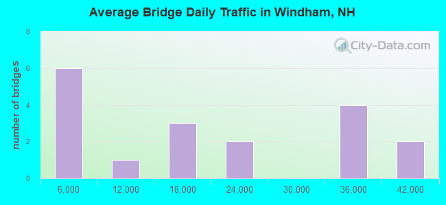
- 317,296Total average daily traffic
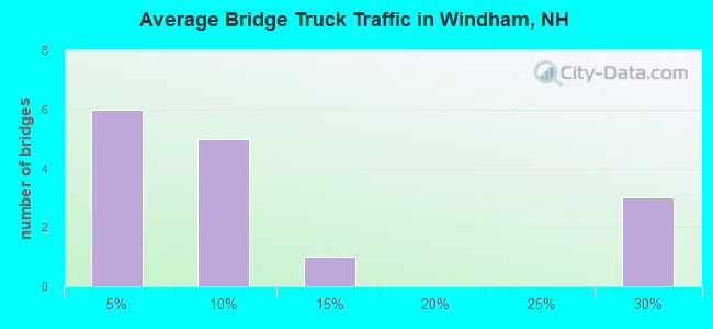
- 38,350Total average daily truck traffic
- National Bridge Inventory (NBI) Registered Bridges for Windham
- No street view available for this location
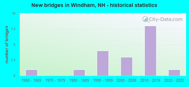
- New bridges - historical statistics
- 11960-1969
- 11980-1989
- 41990-1999
- 32000-2009
- 82010-2019
- 12020-2022
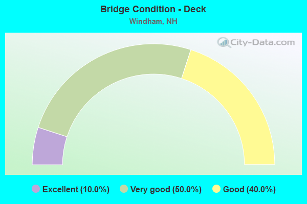
- Bridge Condition - Deck
- 10.0%Excellent
- 50.0%Very good
- 40.0%Good
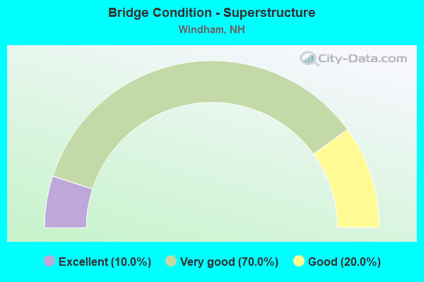
- Bridge Condition - Superstructure
- 10.0%Excellent
- 70.0%Very good
- 20.0%Good
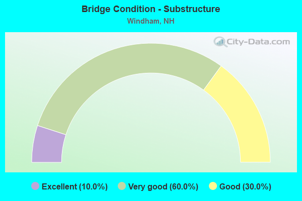
- Bridge Condition - Substructure
- 10.0%Excellent
- 60.0%Very good
- 30.0%Good
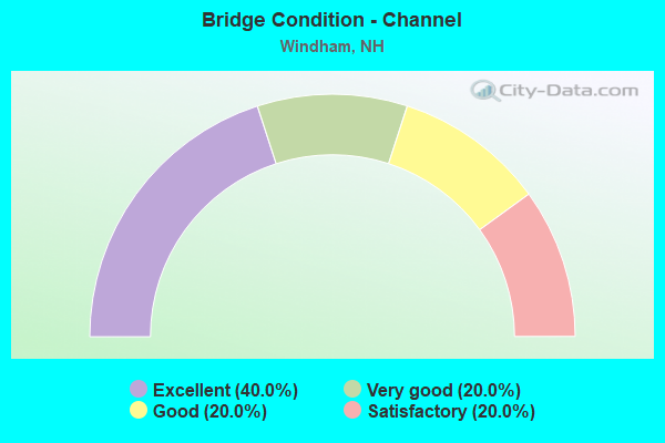
- Bridge Condition - Channel
- 40.0%Excellent
- 20.0%Very good
- 20.0%Good
- 20.0%Satisfactory
Find on map >> Show street view
Structure Number: 280004200082, Location: AT HUDSON TL (Lat: 42.794097, Lng: -71.364003), Route carried "on" structure: State highway 111, Year Built: 1961, Status: Open, Structure Length: 1.16m (3.81ft), Average Daily Traffic: 12,868 (year 2020), Truck Traffic: 7%, Average Future Daily Traffic: 19,044 (year 2042), Design Load: H 20, Features Intersected: BEAVER BROOK
Minimum Vertical Clearance: 30+ m (98+ ft), Kilometerpoint: 19.842, Lanes on structure: 2, Base Highway Network: Yes, Owner: State Highway Agency, Approaching Roadway Width: 12.2m (40.0ft), Skew: 3 degrees, Material/Design: Concrete, Design/Construction: Culvert, Number Of Spans In Main Unit: 1, Length of Maximum Span: 10.7m (35.1ft)
Condition: Channel: Good, Culverts: Good, Operating Rating: 89.8 metric tons, Method Used To Determine Operating Rating: Allowable Stress (AS), Inventory Rating: 32.7 metric tons, Method Used To Determine Inventory Rating: Allowable Stress (AS), Structural Evaluation: Better than present minimum criteria, Waterway Adequacy: Equal to present desirable criteria, Approach Roadway Alignment: Equal to present desirable criteria, Length Of Structure Improvement: 1.16m (3.81ft), Designated Inspection Frequency: Every 24 months, Inspection Date: May 2021, Bridge Improvement Cost: $2,718,000, Roadway Improvement Cost: $200,000, Total Project Cost: $3,142,000 ( Estimate for 2022), Wearing Surface/Protective System: Wearing Surface: Bituminous, Membrane: Other
Find on map >> Show street view
Structure Number: 280005700051, Location: 0.02 MI FR PELHAM TL (Lat: 42.774400, Lng: -71.349897), Route carried "on" structure: Other road , Year Built: 2021, Status: Open, Structure Length: 0.79m (2.59ft), Average Daily Traffic: 242 (year 2020), Truck Traffic: 4%, Average Future Daily Traffic: 358 (year 2042), Design Load: HL 93, Features Intersected: BEAVER BROOK, Facility Carried by Structure: CASTLE HILL ROAD
Minimum Vertical Clearance: 30+ m (98+ ft), Kilometerpoint: 0.014, Lanes on structure: 2, Owner: City or Municipal Highway Agency, Approaching Roadway Width: 7.6m (24.9ft), Material/Design: Concrete, Design/Construction: Frame, Number Of Spans In Main Unit: 1, Length of Maximum Span: 7.3m (24.0ft), Curb or Sidewalk Widths: Left: 0.2m (0.7ft), Right: 0.2m (0.7ft), Curb-To-Curb Width: 7.0m (23.0ft), Out-to-Out Width: 8.5m (27.9ft)
Condition: Deck: Excellent, Superstructure: Excellent, Substructure: Excellent, Channel: Very good, Operating Rating: 63.0 metric tons, Method Used To Determine Operating Rating: Load and Resistance Factor (LRFR), Inventory Rating: 48.6 metric tons, Method Used To Determine Inventory Rating: Load and Resistance Factor (LRFR), Structural Evaluation: Superior to present desirable criteria, Deck Geometry: Meets minimum limits, Waterway Adequacy: Equal to present desirable criteria, Approach Roadway Alignment: Meets minimum limits, Length Of Structure Improvement: 0.79m (2.59ft), Designated Inspection Frequency: Every 24 months, Inspection Date: June 2021, Bridge Improvement Cost: $2,718,000, Roadway Improvement Cost: $200,000, Total Project Cost: $3,142,000 ( Estimate for 2022), Deck Structure Type: Concrete Precast Panels, Wearing Surface/Protective System: Wearing Surface: Bituminous
Find on map >> Show street view
Structure Number: 280010400142, Location: 0.6 MI SOUTH DERRY TL (Lat: 42.836256, Lng: -71.299936), Route carried "on" structure: Interstate 93, Year Built: 1995, Year Reconstructed: 2019, Status: Open, Structure Length: 3.20m (10.50ft), Average Daily Traffic: 32,231 (year 2020), Truck Traffic: 7%, Average Future Daily Traffic: 47,701 (year 2042), Design Load: HS 25 or greater, Features Intersected: NORTH LOWELL ROAD
Minimum Vertical Clearance: 30+ m (98+ ft), Kilometerpoint: 198.794, Lanes on structure: 4, Lanes under structure: 2, Base Highway Network: Yes, Owner: State Highway Agency, Approaching Roadway Width: 21.6m (70.9ft), Skew: 4 degrees, Material/Design: Prestressed concrete, Design/Construction: Stringer/Multi-beam, Number Of Spans In Main Unit: 1, Length of Maximum Span: 29.6m (97.1ft), Curb or Sidewalk Widths: Left: 0.1m (0.3ft), Right: 0.1m (0.3ft), Curb-To-Curb Width: 21.6m (70.9ft), Out-to-Out Width: 22.9m (75.1ft)
Condition: Deck: Very good, Superstructure: Good, Substructure: Good, Operating Rating: 68.9 metric tons, Method Used To Determine Operating Rating: Allowable Stress (AS), Inventory Rating: 42.6 metric tons, Method Used To Determine Inventory Rating: Allowable Stress (AS), Structural Evaluation: Better than present minimum criteria, Deck Geometry: Better than present minimum criteria, Underclear: Equal to present minimum criteria, Approach Roadway Alignment: Equal to present desirable criteria, Length Of Structure Improvement: 3.20m (10.50ft), Designated Inspection Frequency: Every 24 months, Inspection Date: May 2021, Bridge Improvement Cost: $2,718,000, Roadway Improvement Cost: $200,000, Total Project Cost: $3,142,000 ( Estimate for 2022), Deck Structure Type: Concrete Cast-file-Place, Wearing Surface/Protective System: Wearing Surface: Bituminous, Membrane: Preformed Fabric, Deck Protection: Epoxy Coated Reinforcing
Find on map >> Show street view
Structure Number: 280010500142, Location: .6 MI S OF DERRY TL (Lat: 42.836658, Lng: -71.299886), Route carried "on" structure: Interstate 93, Year Built: 1998, Year Reconstructed: 2021, Status: Open, Structure Length: 2.93m (9.61ft), Average Daily Traffic: 31,975 (year 2020), Truck Traffic: 9%, Average Future Daily Traffic: 47,323 (year 2042), Design Load: HS 25 or greater, Features Intersected: NORTH LOWELL ROAD
Minimum Vertical Clearance: 30+ m (98+ ft), Kilometerpoint: 13.469, Lanes on structure: 4, Lanes under structure: 2, Base Highway Network: Yes, Owner: State Highway Agency, Approaching Roadway Width: 23.5m (77.1ft), Skew: 4 degrees, Material/Design: Prestressed concrete, Design/Construction: Stringer/Multi-beam, Number Of Spans In Main Unit: 1, Length of Maximum Span: 27.4m (89.9ft), Curb or Sidewalk Widths: Left: 0.1m (0.3ft), Right: 0.1m (0.3ft), Curb-To-Curb Width: 23.5m (77.1ft), Out-to-Out Width: 24.7m (81.0ft)
Condition: Deck: Good, Superstructure: Very good, Substructure: Good, Operating Rating: 68.0 metric tons, Method Used To Determine Operating Rating: Field evaluation and documented engineering judgment, Inventory Rating: 40.8 metric tons, Method Used To Determine Inventory Rating: Field evaluation and documented engineering judgment, Structural Evaluation: Better than present minimum criteria, Deck Geometry: Superior to present desirable criteria, Underclear: Somewhat better than minimum adequacy, Approach Roadway Alignment: Equal to present desirable criteria, Length Of Structure Improvement: 2.93m (9.61ft), Designated Inspection Frequency: Every 24 months, Inspection Date: May 2021, Bridge Improvement Cost: $2,718,000, Roadway Improvement Cost: $200,000, Total Project Cost: $3,142,000 ( Estimate for 2022), Deck Structure Type: Concrete Cast-file-Place, Wearing Surface/Protective System: Wearing Surface: Bituminous, Membrane: Other, Deck Protection: Epoxy Coated Reinforcing
Find on map >> Show street view
Structure Number: 280010700087, Location: 0.3 MI FROM NH RTE 111 (Lat: 42.799083, Lng: -71.302767), Route carried "on" structure: Other road , Year Built: 1989, Status: Open, Structure Length: 0.72m (2.36ft), Average Daily Traffic: 431 (year 2020), Average Future Daily Traffic: 637 (year 2042), Features Intersected: COLLINS BROOK, Facility Carried by Structure: COLLINS BROOK ROAD
Minimum Vertical Clearance: 30+ m (98+ ft), Kilometerpoint: 0.035, Lanes on structure: 2, Owner: City or Municipal Highway Agency, Approaching Roadway Width: 7.9m (25.9ft), Material/Design: Concrete, Design/Construction: Frame, Number Of Spans In Main Unit: 3, Length of Maximum Span: 2.4m (7.9ft), Curb-To-Curb Width: 8.5m (27.9ft), Out-to-Out Width: 9.2m (30.2ft)
Condition: Deck: Good, Superstructure: Good, Substructure: Good, Channel: Satisfactory, Operating Rating: 25.8 metric tons, Method Used To Determine Operating Rating: Field evaluation and documented engineering judgment, Inventory Rating: 15.5 metric tons, Method Used To Determine Inventory Rating: Field evaluation and documented engineering judgment, Structural Evaluation: Meets minimum limits, Deck Geometry: Somewhat better than minimum adequacy, Waterway Adequacy: Equal to present desirable criteria, Approach Roadway Alignment: Better than present minimum criteria, Length Of Structure Improvement: 0.72m (2.36ft), Designated Inspection Frequency: Every 24 months, Inspection Date: June 2021, Bridge Improvement Cost: $2,718,000, Roadway Improvement Cost: $200,000, Total Project Cost: $3,142,000 ( Estimate for 2022), Deck Structure Type: Concrete Cast-file-Place, Wearing Surface/Protective System: Wearing Surface: Bituminous
Find on map >> Show street view
Structure Number: 28001360009, Location: .7/10 OF MIL WEST NH 111 (Lat: 42.799750, Lng: -71.271964), Route carried "on" structure: Interstate 93, Year Built: 2014, Status: Open, Structure Length: 4.11m (13.48ft), Average Daily Traffic: 39,882 (year 2020), Truck Traffic: 25%, Average Future Daily Traffic: 59,025 (year 2042), Design Load: HS 25 or greater, Features Intersected: NH111A
Minimum Vertical Clearance: 30+ m (98+ ft), Kilometerpoint: 203.743, Lanes on structure: 5, Lanes under structure: 2, Base Highway Network: Yes, Owner: State Highway Agency, Approaching Roadway Width: 29.3m (96.1ft), Skew: 4 degrees, Material/Design: Steel, Design/Construction: Stringer/Multi-beam, Number Of Spans In Main Unit: 1, Length of Maximum Span: 33.8m (110.9ft), Curb or Sidewalk Widths: Left: 0.2m (0.7ft), Right: 0.2m (0.7ft), Curb-To-Curb Width: 29.0m (95.1ft), Out-to-Out Width: 30.2m (99.1ft)
Condition: Deck: Very good, Superstructure: Very good, Substructure: Very good, Operating Rating: 75.1 metric tons, Method Used To Determine Operating Rating: Load Factor (LF), Inventory Rating: 44.9 metric tons, Method Used To Determine Inventory Rating: Load Factor (LF), Structural Evaluation: Equal to present desirable criteria, Deck Geometry: Superior to present desirable criteria, Underclear: Somewhat better than minimum adequacy, Approach Roadway Alignment: Equal to present desirable criteria, Length Of Structure Improvement: 4.11m (13.48ft), Designated Inspection Frequency: Every 24 months, Inspection Date: May 2021, Bridge Improvement Cost: $2,718,000, Roadway Improvement Cost: $200,000, Total Project Cost: $3,142,000 ( Estimate for 2022), Deck Structure Type: Concrete Cast-file-Place, Wearing Surface/Protective System: Wearing Surface: Bituminous, Membrane: Preformed Fabric, Deck Protection: Epoxy Coated Reinforcing
Find on map >> Show street view
Structure Number: 280013700092, Location: .2 M EAST OF ARMSTRONG RD (Lat: 42.800281, Lng: -71.271156), Route carried "on" structure: Interstate I93, Year Built: 2011, Status: Open, Structure Length: 4.24m (13.91ft), Average Daily Traffic: 38,069 (year 2020), Truck Traffic: 10%, Average Future Daily Traffic: 56,342 (year 2042), Design Load: HS 25 or greater, Features Intersected: NH111A, Facility Carried by Structure: I-93 NB
Minimum Vertical Clearance: 30+ m (98+ ft), Kilometerpoint: 8.554, Lanes on structure: 5, Lanes under structure: 2, Base Highway Network: Yes, Owner: State Highway Agency, Approaching Roadway Width: 25.3m (83.0ft), Skew: 5 degrees, Material/Design: Steel, Design/Construction: Stringer/Multi-beam, Number Of Spans In Main Unit: 1, Length of Maximum Span: 40.2m (131.9ft), Curb or Sidewalk Widths: Left: 0.2m (0.7ft), Right: 0.2m (0.7ft), Curb-To-Curb Width: 25.3m (83.0ft), Out-to-Out Width: 26.5m (86.9ft)
Condition: Deck: Good, Superstructure: Very good, Substructure: Very good, Operating Rating: 69.4 metric tons, Method Used To Determine Operating Rating: Load Factor (LF), Inventory Rating: 41.5 metric tons, Method Used To Determine Inventory Rating: Load Factor (LF), Structural Evaluation: Equal to present desirable criteria, Deck Geometry: Better than present minimum criteria, Underclear: Better than present minimum criteria, Approach Roadway Alignment: Equal to present desirable criteria, Length Of Structure Improvement: 4.24m (13.91ft), Designated Inspection Frequency: Every 24 months, Inspection Date: May 2021, Bridge Improvement Cost: $2,718,000, Roadway Improvement Cost: $200,000, Total Project Cost: $3,142,000 ( Estimate for 2022), Deck Structure Type: Concrete Cast-file-Place, Wearing Surface/Protective System: Wearing Surface: Bituminous, Membrane: Preformed Fabric, Deck Protection: Epoxy Coated Reinforcing
Find on map >> Show street view
Structure Number: 280013700102, Location: 3 MI SOUTH OF DERRY TL (Lat: 42.809136, Lng: -71.272594), Route carried "on" structure: Interstate I93, Year Built: 2014, Status: Open, Structure Length: 12.49m (40.98ft), Average Daily Traffic: 32,231 (year 2020), Truck Traffic: 25%, Average Future Daily Traffic: 47,701 (year 2042), Design Load: HL 93, Features Intersected: NH111, Facility Carried by Structure: I-93 SB
Minimum Vertical Clearance: 30+ m (98+ ft), Kilometerpoint: 202.690, Lanes on structure: 4, Lanes under structure: 6, Base Highway Network: Yes, Owner: State Highway Agency, Approaching Roadway Width: 21.6m (70.9ft), Skew: 4 degrees, Material/Design: Steel continuous, Design/Construction: Stringer/Multi-beam, Number Of Spans In Main Unit: 2, Length of Maximum Span: 70.1m (230.0ft), Curb or Sidewalk Widths: Left: 0.2m (0.7ft), Right: 0.2m (0.7ft), Curb-To-Curb Width: 21.6m (70.9ft), Out-to-Out Width: 22.9m (75.1ft)
Condition: Deck: Very good, Superstructure: Very good, Substructure: Very good, Operating Rating: 68.6 metric tons, Method Used To Determine Operating Rating: Load Factor (LF), Inventory Rating: 41.2 metric tons, Method Used To Determine Inventory Rating: Load Factor (LF), Structural Evaluation: Equal to present desirable criteria, Deck Geometry: Better than present minimum criteria, Underclear: High priority of replacement, Approach Roadway Alignment: Equal to present desirable criteria, Length Of Structure Improvement: 12.49m (40.98ft), Designated Inspection Frequency: Every 24 months, Inspection Date: May 2021, Bridge Improvement Cost: $2,718,000, Roadway Improvement Cost: $200,000, Total Project Cost: $3,142,000 ( Estimate for 2022), Deck Structure Type: Concrete Cast-file-Place, Wearing Surface/Protective System: Wearing Surface: Bituminous, Membrane: Preformed Fabric, Deck Protection: Epoxy Coated Reinforcing
Find on map >> Show street view
Structure Number: 280013900102, Location: 0.2 EAST OF WYMAN ROAD (Lat: 42.809075, Lng: -71.271847), Route carried "on" structure: Interstate 93, Year Built: 2011, Status: Open, Structure Length: 11.80m (38.71ft), Average Daily Traffic: 31,975 (year 2020), Truck Traffic: 25%, Average Future Daily Traffic: 47,323 (year 2042), Design Load: HL 93, Features Intersected: NH111
Minimum Vertical Clearance: 30+ m (98+ ft), Kilometerpoint: 9.532, Lanes on structure: 4, Lanes under structure: 6, Base Highway Network: Yes, Owner: State Highway Agency, Approaching Roadway Width: 21.9m (71.9ft), Skew: 4 degrees, Material/Design: Steel continuous, Design/Construction: Stringer/Multi-beam, Number Of Spans In Main Unit: 2, Length of Maximum Span: 70.1m (230.0ft), Curb or Sidewalk Widths: Left: 0.2m (0.7ft), Right: 0.2m (0.7ft), Curb-To-Curb Width: 21.9m (71.9ft), Out-to-Out Width: 22.9m (75.1ft)
Condition: Deck: Very good, Superstructure: Very good, Substructure: Very good, Operating Rating: 63.3 metric tons, Method Used To Determine Operating Rating: Load Factor (LF), Inventory Rating: 38.0 metric tons, Method Used To Determine Inventory Rating: Load Factor (LF), Structural Evaluation: Equal to present desirable criteria, Deck Geometry: Better than present minimum criteria, Underclear: High priority of replacement, Approach Roadway Alignment: Equal to present desirable criteria, Length Of Structure Improvement: 11.80m (38.71ft), Designated Inspection Frequency: Every 24 months, Inspection Date: May 2021, Bridge Improvement Cost: $2,718,000, Roadway Improvement Cost: $200,000, Total Project Cost: $3,142,000 ( Estimate for 2022), Deck Structure Type: Concrete Cast-file-Place, Wearing Surface/Protective System: Wearing Surface: Bituminous, Membrane: Preformed Fabric, Deck Protection: Epoxy Coated Reinforcing
Find on map >> Show street view
Structure Number: 280016100114, Location: 0.5MI EAST NH 28 (Lat: 42.814561, Lng: -71.246539), Route carried "on" structure: State highway , Year Built: 2007, Status: Open, Structure Length: 18.32m (60.10ft), Average Daily Traffic: 16,096 (year 2020), Truck Traffic: 6%, Average Future Daily Traffic: 23,822 (year 2042), Design Load: HS 25 or greater, Features Intersected: HARRIS RD,FLATROCK BK, Facility Carried by Structure: NH111
Minimum Vertical Clearance: 30+ m (98+ ft), Kilometerpoint: 30.619, Lanes on structure: 4, Lanes under structure: 2, Base Highway Network: Yes, Owner: State Highway Agency, Approaching Roadway Width: 26.8m (87.9ft), Skew: 20 degrees, Material/Design: Steel continuous, Design/Construction: Stringer/Multi-beam, Number Of Spans In Main Unit: 4, Length of Maximum Span: 49.1m (161.1ft), Curb or Sidewalk Widths: Left: 0.1m (0.3ft), Right: 0.1m (0.3ft), Curb-To-Curb Width: 9.4m (30.8ft), Out-to-Out Width: 26.2m (86.0ft)
Condition: Deck: Good, Superstructure: Very good, Substructure: Very good, Channel: Excellent, Operating Rating: 68.1 metric tons, Method Used To Determine Operating Rating: Load Factor (LF), Inventory Rating: 40.8 metric tons, Method Used To Determine Inventory Rating: Load Factor (LF), Structural Evaluation: Equal to present desirable criteria, Deck Geometry: High priority of replacement, Underclear: Superior to present desirable criteria, Waterway Adequacy: Superior to present desirable criteria, Approach Roadway Alignment: Superior to present desirable criteria, Length Of Structure Improvement: 18.32m (60.10ft), Designated Inspection Frequency: Every 24 months, Inspection Date: May 2021, Bridge Improvement Cost: $2,718,000, Roadway Improvement Cost: $200,000, Total Project Cost: $3,142,000 ( Estimate for 2022), Deck Structure Type: Concrete Cast-file-Place, Wearing Surface/Protective System: Wearing Surface: Bituminous, Membrane: Other, Deck Protection: Epoxy Coated Reinforcing
Find on map >> Show street view
Structure Number: 280016600123, Location: WINDHAM (Lat: 42.822469, Lng: -71.243511), Route carried "on" structure: State highway 111, Year Built: 2007, Status: Open, Structure Length: 2.01m (6.59ft), Average Daily Traffic: 16,096 (year 2020), Truck Traffic: 6%, Average Future Daily Traffic: 23,822 (year 2042), Design Load: HS 25 or greater, Features Intersected: WETLAND 41
Minimum Vertical Clearance: 30+ m (98+ ft), Kilometerpoint: 31.554, Lanes on structure: 2, Base Highway Network: Yes, Owner: State Highway Agency, Approaching Roadway Width: 13.1m (43.0ft), Skew: 1 degrees, Material/Design: Concrete, Design/Construction: Stringer/Multi-beam, Number Of Spans In Main Unit: 1, Length of Maximum Span: 18.0m (59.1ft), Curb or Sidewalk Widths: Left: 0.1m (0.3ft), Right: 0.1m (0.3ft), Curb-To-Curb Width: 13.1m (43.0ft), Out-to-Out Width: 14.6m (47.9ft)
Condition: Deck: Very good, Superstructure: Very good, Substructure: Very good, Channel: Excellent, Operating Rating: 70.6 metric tons, Method Used To Determine Operating Rating: Load Factor (LF), Inventory Rating: 42.3 metric tons, Method Used To Determine Inventory Rating: Load Factor (LF), Structural Evaluation: Equal to present desirable criteria, Deck Geometry: Somewhat better than minimum adequacy, Waterway Adequacy: Equal to present desirable criteria, Approach Roadway Alignment: Superior to present desirable criteria, Length Of Structure Improvement: 2.01m (6.59ft), Designated Inspection Frequency: Every 24 months, Inspection Date: May 2021, Bridge Improvement Cost: $2,718,000, Roadway Improvement Cost: $200,000, Total Project Cost: $3,142,000 ( Estimate for 2022), Deck Structure Type: Concrete Cast-file-Place, Wearing Surface/Protective System: Wearing Surface: Bituminous, Membrane: Preformed Fabric, Deck Protection: Epoxy Coated Reinforcing
Find on map >> Show street view
Structure Number: 280010400142, Location: 0.6 MI SOUTH DERRY TL (Lat: 42.836256, Lng: -71.299936), Route carried "under" structure: City street , Year Built: 1995, Structure Length: 0. m, Average Daily Traffic: 5,000 (year 2014), Features Intersected: NORTH LOWELL ROAD, Facility Carried by Structure: I-93 SB
Minimum Vertical Clearance: 4.85m (15.91ft), Kilometerpoint: 0.000, Lanes on structure: 4, Lanes under structure: 2, Material/Design: Prestressed concrete, Design/Construction: Stringer/Multi-beam, Length of Maximum Span: 29.6m (97.1ft)
Find on map >> Show street view
Structure Number: 280010500142, Location: .6 MI S OF DERRY TL (Lat: 42.836658, Lng: -71.299886), Route carried "under" structure: City street , Year Built: 1998, Structure Length: 0. m, Average Daily Traffic: 5,000 (year 2014), Features Intersected: NORTH LOWELL ROAD, Facility Carried by Structure: I-93 NB
Minimum Vertical Clearance: 4.85m (15.91ft), Kilometerpoint: 0.000, Lanes on structure: 4, Lanes under structure: 2, Material/Design: Prestressed concrete, Design/Construction: Stringer/Multi-beam, Length of Maximum Span: 27.4m (89.9ft)
Find on map >> Show street view
Structure Number: 28001360009, Location: .7/10 OF MIL WEST NH 111 (Lat: 42.799750, Lng: -71.271964), Route carried "under" structure: State highway , Year Built: 2014, Structure Length: 0. m, Average Daily Traffic: 9,100 (year 2013), Truck Traffic: 1%, Features Intersected: NH111A, Facility Carried by Structure: I-93 SB
Minimum Vertical Clearance: 4.65m (15.26ft), Kilometerpoint: 0.000, Lanes on structure: 5, Lanes under structure: 2, Material/Design: Steel, Design/Construction: Stringer/Multi-beam, Length of Maximum Span: 33.8m (110.9ft)
Find on map >> Show street view
Structure Number: 280013700092, Location: .2 M EAST OF ARMSTRONG RD (Lat: 42.800281, Lng: -71.271156), Route carried "under" structure: Alternate State highway , Year Built: 2011, Structure Length: 0. m, Average Daily Traffic: 4,000 (year 2013), Truck Traffic: 1%, Features Intersected: NH111A, Facility Carried by Structure: I-93 NB
Minimum Vertical Clearance: 4.75m (15.58ft), Kilometerpoint: 0.000, Lanes on structure: 5, Lanes under structure: 2, Material/Design: Steel, Design/Construction: Stringer/Multi-beam, Length of Maximum Span: 40.2m (131.9ft)
Find on map >> Show street view
Structure Number: 280013700102, Location: 3 MI SOUTH OF DERRY TL (Lat: 42.809136, Lng: -71.272594), Route carried "under" structure: State highway 111, Year Built: 2014, Structure Length: 0. m, Average Daily Traffic: 21,000 (year 2010), Truck Traffic: 1%, Features Intersected: NH111, Facility Carried by Structure: I-93 SB
Minimum Vertical Clearance: 7.70m (25.26ft), Kilometerpoint: 0.000, Lanes on structure: 4, Lanes under structure: 6, Material/Design: Steel continuous, Design/Construction: Stringer/Multi-beam, Length of Maximum Span: 70.1m (230.0ft)
Find on map >> Show street view
Structure Number: 280013900102, Location: 0.2 EAST OF WYMAN ROAD (Lat: 42.809075, Lng: -71.271847), Route carried "under" structure: State highway , Year Built: 2011, Structure Length: 0. m, Average Daily Traffic: 21,000 (year 2010), Truck Traffic: 1%, Features Intersected: NH111, Facility Carried by Structure: I-93 NB
Minimum Vertical Clearance: 9.63m (31.59ft), Kilometerpoint: 0.000, Lanes on structure: 4, Lanes under structure: 6, Material/Design: Steel continuous, Design/Construction: Stringer/Multi-beam, Length of Maximum Span: 70.1m (230.0ft)
Find on map >> Show street view
Structure Number: 280016100114, Location: 0.5MI EAST NH 28 (Lat: 42.814561, Lng: -71.246539), Route carried "under" structure: Alternate City street , Year Built: 2007, Structure Length: 0. m, Average Daily Traffic: 100 (year 2019), Truck Traffic: 1%, Features Intersected: HARRIS RD,FLATROCK BK, Facility Carried by Structure: NH111
Minimum Vertical Clearance: 5.49m (18.01ft), Kilometerpoint: 0.000, Lanes on structure: 4, Lanes under structure: 2, Material/Design: Steel continuous, Design/Construction: Stringer/Multi-beam, Length of Maximum Span: 49.1m (161.1ft)