Bridge Statistics for Windham, New York (NY)
Condition, Traffic, Stress, Structural Evaluation, Project Costs
- National Bridge Inventory (NBI) Statistics
- 19Number of bridges
- 135ft / 41.3mTotal length
- $26,103,000Total costs
- 19,719Total average daily traffic
- 1,860Total average daily truck traffic
- 22,212Total future (year 2037) average daily traffic
- National Bridge Inventory (NBI) Registered Bridges for Windham
- No street view available for this location
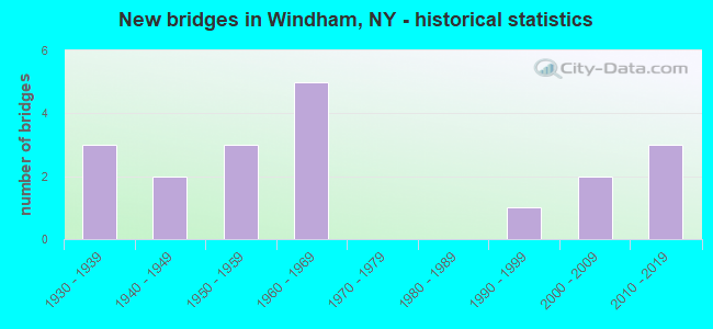
- New bridges - historical statistics
- 31930-1939
- 21940-1949
- 31950-1959
- 51960-1969
- 11990-1999
- 22000-2009
- 32010-2019

- Reconstructed bridges - Historical Statistics
- 31980-1989
- 01990-1999
- 12000-2009
- 22010-2019

- Bridge Condition - Deck
- 15.8%Excellent
- 21.1%Very good
- 26.3%Good
- 5.3%Satisfactory
- 26.3%Fair
- 5.3%Poor

- Bridge Condition - Superstructure
- 31.6%Excellent
- 10.5%Very good
- 10.5%Good
- 21.1%Satisfactory
- 21.1%Fair
- 5.3%Poor

- Bridge Condition - Substructure
- 21.1%Excellent
- 10.5%Very good
- 21.1%Good
- 26.3%Satisfactory
- 15.8%Fair
- 5.3%Critical

- Bridge Condition - Channel
- 21.1%Very good
- 15.8%Good
- 26.3%Satisfactory
- 31.6%Fair
- 5.3%Poor
Find on map >> Show street view
Structure Number: 101769, Location: RT 23 4.6 MI W OF WINDHAM (Lat: 42.303536, Lng: -74.333592), Route carried "on" structure: State highway 23, Year Built: 1945, Status: Open, Structure Length: 1.37m (4.49ft), Average Daily Traffic: 1,011 (year 2016), Truck Traffic: 12%, Average Future Daily Traffic: 1,078 (year 2040), Design Load: H 20, Features Intersected: WEST HOLLOW BROOK
Minimum Vertical Clearance: 30+ m (98+ ft), Kilometerpoint: 11.955, Lanes on structure: 2, Base Highway Network: Yes, Owner: State Highway Agency, Approaching Roadway Width: 10.4m (34.1ft), Skew: 1 degrees, Material/Design: Steel, Design/Construction: Stringer/Multi-beam, Number Of Spans In Main Unit: 1, Length of Maximum Span: 13.4m (44.0ft), Curb or Sidewalk Widths: Left: 1.3m (4.3ft), Right: 1.3m (4.3ft), Curb-To-Curb Width: 10.4m (34.1ft), Out-to-Out Width: 14.0m (45.9ft)
Condition: Deck: Fair, Superstructure: Fair, Substructure: Fair, Channel: Satisfactory, Operating Rating: 28.5 metric tons, Method Used To Determine Operating Rating: Load and Resistance Factor Rating (LRFR) rating reported by rating factor(RF) method using HL-93 loadings, Inventory Rating: 22.0 metric tons, Method Used To Determine Inventory Rating: Load and Resistance Factor Rating (LRFR) rating reported by rating factor(RF) method using HL-93 loadings, Structural Evaluation: Somewhat better than minimum adequacy, Deck Geometry: Equal to present minimum criteria, Waterway Adequacy: Equal to present minimum criteria, Approach Roadway Alignment: Equal to present desirable criteria, Length Of Structure Improvement: 1.37m (4.49ft), Designated Inspection Frequency: Every 24 months, Inspection Date: June 2020, Bridge Improvement Cost: $769,000, Roadway Improvement Cost: $450,000, Total Project Cost: $1,219,000 ( Estimate for 2021), Deck Structure Type: Concrete Cast-file-Place, Wearing Surface/Protective System: Wearing Surface: Bituminous
Find on map >> Show street view
Structure Number: 10177, Location: RT 23 2.5 MI W OF WINDHAM (Lat: 42.299439, Lng: -74.296350), Route carried "on" structure: State highway 23, Year Built: 1944, Year Reconstructed: 2012, Status: Open, Structure Length: 1.28m (4.20ft), Average Daily Traffic: 2,175 (year 2019), Truck Traffic: 10%, Average Future Daily Traffic: 2,319 (year 2040), Design Load: H 20, Features Intersected: SUTTON HOLLOW CRK
Minimum Vertical Clearance: 30+ m (98+ ft), Kilometerpoint: 15.479, Lanes on structure: 2, Base Highway Network: Yes, Owner: State Highway Agency, Approaching Roadway Width: 10.7m (35.1ft), Material/Design: Steel, Design/Construction: Stringer/Multi-beam, Number Of Spans In Main Unit: 1, Length of Maximum Span: 12.2m (40.0ft), Curb-To-Curb Width: 10.7m (35.1ft), Out-to-Out Width: 11.7m (38.4ft)
Condition: Deck: Good, Superstructure: Fair, Substructure: Good, Channel: Satisfactory, Operating Rating: 61.2 metric tons, Method Used To Determine Operating Rating: Load and Resistance Factor Rating (LRFR) rating reported by rating factor(RF) method using HL-93 loadings, Inventory Rating: 47.3 metric tons, Method Used To Determine Inventory Rating: Load and Resistance Factor Rating (LRFR) rating reported by rating factor(RF) method using HL-93 loadings, Structural Evaluation: Somewhat better than minimum adequacy, Deck Geometry: Somewhat better than minimum adequacy, Waterway Adequacy: Somewhat better than minimum adequacy, Approach Roadway Alignment: Equal to present desirable criteria, Length Of Structure Improvement: 1.28m (4.20ft), Designated Inspection Frequency: Every 24 months, Inspection Date: June 2020, Bridge Improvement Cost: $572,000, Roadway Improvement Cost: $335,000, Total Project Cost: $906,000 ( Estimate for 2021), Deck Structure Type: Concrete Cast-file-Place, Wearing Surface/Protective System: Wearing Surface: Integral Concrete, Deck Protection: Epoxy Coated Reinforcing
Find on map >> Show street view
Structure Number: 101771, Location: RT 23 0.4 MI W OF WINDHAM (Lat: 42.307767, Lng: -74.249642), Route carried "on" structure: State highway 23, Year Built: 1938, Year Reconstructed: 1992, Status: Open, Structure Length: 1.01m (3.31ft), Average Daily Traffic: 2,175 (year 2019), Truck Traffic: 10%, Average Future Daily Traffic: 2,319 (year 2040), Design Load: HS 20, Features Intersected: MAD BROOK
Minimum Vertical Clearance: 30+ m (98+ ft), Kilometerpoint: 19.662, Lanes on structure: 2, Base Highway Network: Yes, Owner: State Highway Agency, Approaching Roadway Width: 13.4m (44.0ft), Material/Design: Steel, Design/Construction: Stringer/Multi-beam, Number Of Spans In Main Unit: 1, Length of Maximum Span: 9.7m (31.8ft), Curb or Sidewalk Widths: Left: 2.5m (8.2ft), Right: 1.5m (4.9ft), Curb-To-Curb Width: 13.4m (44.0ft), Out-to-Out Width: 18.2m (59.7ft)
Condition: Deck: Satisfactory, Superstructure: Good, Substructure: Very good, Channel: Good, Operating Rating: 61.7 metric tons, Method Used To Determine Operating Rating: Load Factor (LF), Inventory Rating: 36.3 metric tons, Method Used To Determine Inventory Rating: Load Factor (LF), Structural Evaluation: Better than present minimum criteria, Deck Geometry: Better than present minimum criteria, Waterway Adequacy: Somewhat better than minimum adequacy, Approach Roadway Alignment: Equal to present desirable criteria, Length Of Structure Improvement: 1.00m (3.28ft), Designated Inspection Frequency: Every 24 months, Inspection Date: August 2021, Bridge Improvement Cost: $687,000, Roadway Improvement Cost: $403,000, Total Project Cost: $1,090,000 ( Estimate for 2021), Deck Structure Type: Concrete Cast-file-Place, Wearing Surface/Protective System: Wearing Surface: Integral Concrete, Deck Protection: Epoxy Coated Reinforcing
Find on map >> Show street view
Structure Number: 101772, Location: 0.2 MI W JCT RTS 23 & 296 (Lat: 42.308892, Lng: -74.233894), Route carried "on" structure: State highway 23, Year Built: 1959, Status: Open, Structure Length: 0.85m (2.79ft), Average Daily Traffic: 2,175 (year 2019), Truck Traffic: 10%, Average Future Daily Traffic: 2,319 (year 2040), Design Load: HS 20, Features Intersected: NAUVO STREAM
Minimum Vertical Clearance: 30+ m (98+ ft), Kilometerpoint: 21.030, Lanes on structure: 2, Base Highway Network: Yes, Owner: State Highway Agency, Approaching Roadway Width: 11.9m (39.0ft), Material/Design: Concrete, Design/Construction: Slab, Number Of Spans In Main Unit: 1, Length of Maximum Span: 8.2m (26.9ft), Curb-To-Curb Width: 11.9m (39.0ft), Out-to-Out Width: 12.5m (41.0ft)
Condition: Deck: Poor, Superstructure: Poor, Substructure: Satisfactory, Channel: Satisfactory, Operating Rating: 59.0 metric tons, Method Used To Determine Operating Rating: Load Factor (LF), Inventory Rating: 34.5 metric tons, Method Used To Determine Inventory Rating: Load Factor (LF), Structural Evaluation: Meets minimum limits, Deck Geometry: Somewhat better than minimum adequacy, Waterway Adequacy: Somewhat better than minimum adequacy, Approach Roadway Alignment: Equal to present desirable criteria, Length Of Structure Improvement: 0.85m (2.79ft), Designated Inspection Frequency: Every 24 months, Inspection Date: November 2020, Bridge Improvement Cost: $822,000, Roadway Improvement Cost: $481,000, Total Project Cost: $1,303,000 ( Estimate for 2021), Wearing Surface/Protective System: Wearing Surface: Latex Concrete
Find on map >> Show street view
Structure Number: 101773, Location: 1.7 MI E JCT RTS 23 & 296 (Lat: 42.303772, Lng: -74.201842), Route carried "on" structure: State highway 23, Year Built: 1959, Status: Open, Structure Length: 1.19m (3.90ft), Average Daily Traffic: 2,282 (year 2018), Truck Traffic: 15%, Average Future Daily Traffic: 2,433 (year 2040), Design Load: HS 20, Features Intersected: BATAVIA KILL TRIB
Minimum Vertical Clearance: 30+ m (98+ ft), Kilometerpoint: 23.845, Lanes on structure: 2, Base Highway Network: Yes, Owner: State Highway Agency, Approaching Roadway Width: 11.0m (36.1ft), Skew: 1 degrees, Material/Design: Concrete, Design/Construction: Tee Beam, Number Of Spans In Main Unit: 1, Length of Maximum Span: 11.2m (36.7ft), Curb or Sidewalk Widths: Left: 0.7m (2.3ft), Right: 0.7m (2.3ft), Curb-To-Curb Width: 11.0m (36.1ft), Out-to-Out Width: 12.5m (41.0ft)
Condition: Deck: Fair, Superstructure: Satisfactory, Substructure: Satisfactory, Channel: Very good, Operating Rating: 70.8 metric tons, Method Used To Determine Operating Rating: Load Factor (LF), Inventory Rating: 42.6 metric tons, Method Used To Determine Inventory Rating: Load Factor (LF), Structural Evaluation: Equal to present minimum criteria, Deck Geometry: Somewhat better than minimum adequacy, Waterway Adequacy: Equal to present minimum criteria, Approach Roadway Alignment: Equal to present desirable criteria, Length Of Structure Improvement: 1.18m (3.87ft), Designated Inspection Frequency: Every 24 months, Inspection Date: May 2020, Bridge Improvement Cost: $913,000, Roadway Improvement Cost: $535,000, Total Project Cost: $1,448,000 ( Estimate for 2021), Deck Structure Type: Concrete Cast-file-Place, Wearing Surface/Protective System: Wearing Surface: Bituminous
Find on map >> Show street view
Structure Number: 101774, Location: 2.1 MI E JCT RTS 23 & 296 (Lat: 42.307306, Lng: -74.193194), Route carried "on" structure: State highway 23, Year Built: 1959, Status: Open, Structure Length: 1.58m (5.18ft), Average Daily Traffic: 2,282 (year 2018), Truck Traffic: 15%, Average Future Daily Traffic: 2,433 (year 2040), Design Load: HS 20, Features Intersected: BATAVIA KILL TRIB
Minimum Vertical Clearance: 30+ m (98+ ft), Kilometerpoint: 24.666, Lanes on structure: 2, Base Highway Network: Yes, Owner: State Highway Agency, Approaching Roadway Width: 11.0m (36.1ft), Skew: 4 degrees, Material/Design: Steel, Design/Construction: Stringer/Multi-beam, Number Of Spans In Main Unit: 1, Length of Maximum Span: 14.0m (45.9ft), Curb or Sidewalk Widths: Left: 0.5m (1.6ft), Right: 0.5m (1.6ft), Curb-To-Curb Width: 11.0m (36.1ft), Out-to-Out Width: 12.6m (41.3ft)
Condition: Deck: Fair, Superstructure: Satisfactory, Substructure: Fair, Channel: Satisfactory, Operating Rating: 68.0 metric tons, Method Used To Determine Operating Rating: Load and Resistance Factor Rating (LRFR) rating reported by rating factor(RF) method using HL-93 loadings, Inventory Rating: 52.5 metric tons, Method Used To Determine Inventory Rating: Load and Resistance Factor Rating (LRFR) rating reported by rating factor(RF) method using HL-93 loadings, Structural Evaluation: Somewhat better than minimum adequacy, Deck Geometry: Somewhat better than minimum adequacy, Waterway Adequacy: Equal to present minimum criteria, Approach Roadway Alignment: Equal to present desirable criteria, Length Of Structure Improvement: 1.58m (5.18ft), Designated Inspection Frequency: Every 24 months, Inspection Date: March 2020, Bridge Improvement Cost: $1,081,000, Roadway Improvement Cost: $633,000, Total Project Cost: $1,714,000 ( Estimate for 2021), Deck Structure Type: Concrete Cast-file-Place, Wearing Surface/Protective System: Wearing Surface: Bituminous
Find on map >> Show street view
Structure Number: 104516, Location: 0.1 MI S JCT RTS 23 & 296 (Lat: 42.308228, Lng: -74.231392), Route carried "on" structure: State highway 296, Year Built: 1932, Year Reconstructed: 1989, Status: Open, Structure Length: 3.81m (12.50ft), Average Daily Traffic: 1,642 (year 2016), Truck Traffic: 5%, Average Future Daily Traffic: 1,712 (year 2040), Features Intersected: BATAVIA KILL
Minimum Vertical Clearance: 30+ m (98+ ft), Kilometerpoint: 12.566, Lanes on structure: 2, Base Highway Network: Yes, Owner: State Highway Agency, Approaching Roadway Width: 9.1m (29.9ft), Skew: 2 degrees, Material/Design: Steel, Design/Construction: Truss - Thru, Number Of Spans In Main Unit: 1, Length of Maximum Span: 36.5m (119.8ft), Curb or Sidewalk Widths: Left: 2.3m (7.5ft), Right: 0.0m, Curb-To-Curb Width: 7.3m (24.0ft), Out-to-Out Width: 8.1m (26.6ft)
Condition: Deck: Fair, Superstructure: Fair, Substructure: Satisfactory, Channel: Fair, Operating Rating: 68.9 metric tons, Method Used To Determine Operating Rating: Load Factor (LF), Inventory Rating: 40.8 metric tons, Method Used To Determine Inventory Rating: Load Factor (LF), Structural Evaluation: Somewhat better than minimum adequacy, Deck Geometry: Meets minimum limits, Waterway Adequacy: Equal to present desirable criteria, Approach Roadway Alignment: Equal to present desirable criteria, Length Of Structure Improvement: 3.81m (12.50ft), Designated Inspection Frequency: Every 24 months, Critical Feature Inspection Frequency: Every 12 months, Inspection Date: May 2021, Critical Feature Inspection Date: May 2021, Bridge Improvement Cost: $3,323,000, Roadway Improvement Cost: $1,946,000, Total Project Cost: $5,269,000 ( Estimate for 2021), Deck Structure Type: Concrete Cast-file-Place, Wearing Surface/Protective System: Wearing Surface: Integral Concrete, Deck Protection: Epoxy Coated Reinforcing
Find on map >> Show street view
Structure Number: 320054, Location: 2.3 MI NE ASHLAND (Lat: 42.319589, Lng: -74.293325), Route carried "on" structure: Other road , Year Built: 1961, Status: Open, Structure Length: 1.34m (4.40ft), Average Daily Traffic: 66 (year 2020), Truck Traffic: 6%, Average Future Daily Traffic: 92 (year 2040), Features Intersected: TRIB to BATAVIA KILL, Facility Carried by Structure: CASE ROAD
Minimum Vertical Clearance: 30+ m (98+ ft), Kilometerpoint: 0.322, Lanes on structure: 2, Owner: County Highway Agency, Approaching Roadway Width: 5.5m (18.0ft), Skew: 1 degrees, Material/Design: Prestressed concrete, Design/Construction: Tee Beam, Number Of Spans In Main Unit: 1, Length of Maximum Span: 12.4m (40.7ft), Curb-To-Curb Width: 6.6m (21.7ft), Out-to-Out Width: 7.4m (24.3ft)
Condition: Deck: Very good, Superstructure: Satisfactory, Substructure: Fair, Channel: Fair, Operating Rating: 81.5 metric tons, Method Used To Determine Operating Rating: Field evaluation and documented engineering judgment, Inventory Rating: 32.7 metric tons, Method Used To Determine Inventory Rating: Field evaluation and documented engineering judgment, Structural Evaluation: Somewhat better than minimum adequacy, Deck Geometry: Somewhat better than minimum adequacy, Waterway Adequacy: Meets minimum limits, Approach Roadway Alignment: Somewhat better than minimum adequacy, Length Of Structure Improvement: 1.34m (4.40ft), Designated Inspection Frequency: Every 24 months, Inspection Date: May 2021, Bridge Improvement Cost: $427,000, Roadway Improvement Cost: $250,000, Total Project Cost: $676,000 ( Estimate for 2021), Deck Structure Type: Concrete Cast-file-Place, Wearing Surface/Protective System: Wearing Surface: Bituminous
Find on map >> Show street view
Structure Number: 320055, Location: 2.3 MI NW WINDHAM (Lat: 42.324172, Lng: -74.290869), Route carried "on" structure: Other road , Year Built: 1961, Year Reconstructed: 2016, Status: Open, Structure Length: 1.43m (4.69ft), Average Daily Traffic: 133 (year 2020), Truck Traffic: 6%, Average Future Daily Traffic: 186 (year 2040), Design Load: HL 93, Features Intersected: BATAVIA KILL TRI, Facility Carried by Structure: STEINMETZ ROAD
Minimum Vertical Clearance: 30+ m (98+ ft), Kilometerpoint: 0.097, Lanes on structure: 2, Owner: County Highway Agency, Approaching Roadway Width: 5.5m (18.0ft), Skew: 3 degrees, Material/Design: Prestressed concrete, Design/Construction: Box Beam or Girders - Multiple, Number Of Spans In Main Unit: 1, Length of Maximum Span: 13.1m (43.0ft), Curb-To-Curb Width: 6.1m (20.0ft), Out-to-Out Width: 7.1m (23.3ft)
Condition: Deck: Very good, Superstructure: Excellent, Substructure: Very good, Channel: Good, Operating Rating: 60.3 metric tons, Method Used To Determine Operating Rating: Load and Resistance Factor Rating (LRFR) rating reported by rating factor(RF) method using HL-93 loadings, Inventory Rating: 46.3 metric tons, Method Used To Determine Inventory Rating: Load and Resistance Factor Rating (LRFR) rating reported by rating factor(RF) method using HL-93 loadings, Structural Evaluation: Equal to present desirable criteria, Deck Geometry: Meets minimum limits, Waterway Adequacy: Meets minimum limits, Approach Roadway Alignment: Equal to present desirable criteria, Length Of Structure Improvement: 1.43m (4.69ft), Designated Inspection Frequency: Every 24 months, Inspection Date: September 2020, Bridge Improvement Cost: $395,000, Roadway Improvement Cost: $231,000, Total Project Cost: $626,000 ( Estimate for 2021), Wearing Surface/Protective System: Wearing Surface: Bituminous
Find on map >> Show street view
Structure Number: 320137, Location: 4 MI SE HMLT OF WINDHAM (Lat: 42.281119, Lng: -74.181858), Route carried "on" structure: Other road , Year Built: 2014, Status: Open, Structure Length: 2.24m (7.35ft), Average Daily Traffic: 84 (year 2018), Average Future Daily Traffic: 118 (year 2038), Features Intersected: BATAVIA KILL, Facility Carried by Structure: SLATER ROAD
Minimum Vertical Clearance: 30+ m (98+ ft), Kilometerpoint: 0.016, Lanes on structure: 2, Owner: County Highway Agency, Approaching Roadway Width: 6.7m (22.0ft), Skew: 2 degrees, Material/Design: Prestressed concrete, Design/Construction: Box Beam or Girders - Multiple, Number Of Spans In Main Unit: 1, Length of Maximum Span: 21.9m (71.9ft), Curb-To-Curb Width: 6.6m (21.7ft), Out-to-Out Width: 7.7m (25.3ft)
Condition: Deck: Excellent, Superstructure: Excellent, Substructure: Excellent, Channel: Very good, Operating Rating: 57.2 metric tons, Method Used To Determine Operating Rating: Load Factor (LF), Inventory Rating: 34.5 metric tons, Method Used To Determine Inventory Rating: Load Factor (LF), Structural Evaluation: Superior to present desirable criteria, Deck Geometry: Somewhat better than minimum adequacy, Waterway Adequacy: Equal to present desirable criteria, Approach Roadway Alignment: Equal to present minimum criteria, Length Of Structure Improvement: 2.24m (7.35ft), Designated Inspection Frequency: Every 24 months, Inspection Date: November 2020, Bridge Improvement Cost: $468,000, Roadway Improvement Cost: $274,000, Total Project Cost: $743,000 ( Estimate for 2021), Deck Structure Type: Concrete Cast-file-Place, Wearing Surface/Protective System: Wearing Surface: Integral Concrete, Deck Protection: Epoxy Coated Reinforcing
Find on map >> Show street view
Structure Number: 330283, Location: 1 MILE SW OF WINDHAM (Lat: 42.303153, Lng: -74.271869), Route carried "on" structure: County highway , Year Built: 1964, Status: Open, Structure Length: 5.67m (18.60ft), Average Daily Traffic: 546 (year 2019), Truck Traffic: 5%, Average Future Daily Traffic: 569 (year 2040), Design Load: H 20, Features Intersected: BATAVIA KILL, Facility Carried by Structure: COUNTY ROAD 12
Minimum Vertical Clearance: 30+ m (98+ ft), Kilometerpoint: 0.145, Lanes on structure: 2, Owner: County Highway Agency, Approaching Roadway Width: 7.3m (24.0ft), Skew: 1 degrees, Material/Design: Steel, Design/Construction: Stringer/Multi-beam, Number Of Spans In Main Unit: 3, Length of Maximum Span: 18.2m (59.7ft), Curb or Sidewalk Widths: Left: 0.5m (1.6ft), Right: 0.5m (1.6ft), Curb-To-Curb Width: 7.3m (24.0ft), Out-to-Out Width: 8.9m (29.2ft)
Condition: Deck: Good, Superstructure: Good, Substructure: Good, Channel: Fair, Operating Rating: 89.8 metric tons, Method Used To Determine Operating Rating: Load Factor (LF), Inventory Rating: 53.5 metric tons, Method Used To Determine Inventory Rating: Load Factor (LF), Structural Evaluation: Better than present minimum criteria, Deck Geometry: Meets minimum limits, Waterway Adequacy: Meets minimum limits, Approach Roadway Alignment: Equal to present minimum criteria, Length Of Structure Improvement: 5.66m (18.57ft), Designated Inspection Frequency: Every 24 months, Inspection Date: June 2021, Bridge Improvement Cost: $1,178,000, Roadway Improvement Cost: $690,000, Total Project Cost: $1,868,000 ( Estimate for 2021), Deck Structure Type: Concrete Cast-file-Place, Wearing Surface/Protective System: Wearing Surface: Monolithic Concrete
Find on map >> Show street view
Structure Number: 330284, Location: 2.5 MI N HMLT OF WINDHAM (Lat: 42.343003, Lng: -74.246833), Route carried "on" structure: County highway , Year Built: 1961, Year Reconstructed: 2017, Status: Open, Structure Length: 0.88m (2.89ft), Average Daily Traffic: 569 (year 2017), Truck Traffic: 10%, Average Future Daily Traffic: 797 (year 2037), Design Load: HL 93, Features Intersected: MAD BROOK, Facility Carried by Structure: MITCHELL HOLLOW RD
Minimum Vertical Clearance: 30+ m (98+ ft), Kilometerpoint: 3.974, Lanes on structure: 2, Owner: County Highway Agency, Approaching Roadway Width: 7.7m (25.3ft), Material/Design: Prestressed concrete, Design/Construction: Box Beam or Girders - Multiple, Number Of Spans In Main Unit: 1, Length of Maximum Span: 8.5m (27.9ft), Curb-To-Curb Width: 7.7m (25.3ft), Out-to-Out Width: 8.7m (28.5ft)
Condition: Deck: Excellent, Superstructure: Excellent, Substructure: Satisfactory, Channel: Fair, Inventory Rating: 63.5 metric tons, Method Used To Determine Inventory Rating: Load Factor (LF), Structural Evaluation: Equal to present minimum criteria, Deck Geometry: Meets minimum limits, Waterway Adequacy: High priority of corrective action, Approach Roadway Alignment: Equal to present desirable criteria, Length Of Structure Improvement: 0.88m (2.89ft), Designated Inspection Frequency: Every 24 months, Inspection Date: August 2021, Bridge Improvement Cost: $420,000, Roadway Improvement Cost: $246,000, Total Project Cost: $666,000 ( Estimate for 2021), Wearing Surface/Protective System: Wearing Surface: Bituminous
Find on map >> Show street view
Structure Number: 330285, Location: HAMLET OF HENSONVILLE (Lat: 42.288311, Lng: -74.214903), Route carried "on" structure: County highway , Year Built: 2013, Status: Open, Structure Length: 2.13m (6.99ft), Average Daily Traffic: 714 (year 2017), Truck Traffic: 7%, Average Future Daily Traffic: 1,000 (year 2037), Features Intersected: BATAVIA KILL, Facility Carried by Structure: COUNTY ROAD 40
Minimum Vertical Clearance: 30+ m (98+ ft), Kilometerpoint: 6.066, Lanes on structure: 2, Owner: County Highway Agency, Approaching Roadway Width: 7.9m (25.9ft), Skew: 1 degrees, Material/Design: Prestressed concrete, Design/Construction: Box Beam or Girders - Multiple, Number Of Spans In Main Unit: 1, Length of Maximum Span: 20.4m (66.9ft), Curb-To-Curb Width: 7.9m (25.9ft), Out-to-Out Width: 8.9m (29.2ft)
Condition: Deck: Very good, Superstructure: Excellent, Substructure: Excellent, Channel: Very good, Operating Rating: 78.0 metric tons, Method Used To Determine Operating Rating: Load Factor (LF), Inventory Rating: 38.1 metric tons, Method Used To Determine Inventory Rating: Load Factor (LF), Structural Evaluation: Superior to present desirable criteria, Deck Geometry: Somewhat better than minimum adequacy, Waterway Adequacy: Equal to present minimum criteria, Approach Roadway Alignment: Somewhat better than minimum adequacy, Length Of Structure Improvement: 2.13m (6.99ft), Designated Inspection Frequency: Every 24 months, Inspection Date: April 2021, Bridge Improvement Cost: $754,000, Roadway Improvement Cost: $441,000, Total Project Cost: $1,195,000 ( Estimate for 2021), Deck Structure Type: Concrete Cast-file-Place, Wearing Surface/Protective System: Wearing Surface: Integral Concrete, Deck Protection: Epoxy Coated Reinforcing
Find on map >> Show street view
Structure Number: 330286, Location: 0.1MI.SWHMLT.MAPLECREST (Lat: 42.275097, Lng: -74.187583), Route carried "on" structure: Other road , Year Built: 1936, Year Reconstructed: 1989, Status: Open, Structure Length: 1.58m (5.18ft), Average Daily Traffic: 619 (year 2019), Truck Traffic: 5%, Average Future Daily Traffic: 867 (year 2039), Design Load: HS 20, Features Intersected: BATAVIA KILL, Facility Carried by Structure: CR40-MAPLECREST R
Minimum Vertical Clearance: 30+ m (98+ ft), Kilometerpoint: 3.073, Lanes on structure: 2, Owner: County Highway Agency, Approaching Roadway Width: 6.7m (22.0ft), Material/Design: Prestressed concrete, Design/Construction: Box Beam or Girders - Multiple, Number Of Spans In Main Unit: 1, Length of Maximum Span: 15.2m (49.9ft), Curb-To-Curb Width: 6.8m (22.3ft), Out-to-Out Width: 7.4m (24.3ft)
Condition: Deck: Fair, Superstructure: Fair, Substructure: Critical, Channel: Poor, Operating Rating: 78.0 metric tons, Method Used To Determine Operating Rating: Load Factor (LF), Inventory Rating: 47.2 metric tons, Method Used To Determine Inventory Rating: Load Factor (LF), Structural Evaluation: High priority of replacement, Deck Geometry: Meets minimum limits, Waterway Adequacy: Meets minimum limits, Approach Roadway Alignment: Equal to present desirable criteria, Length Of Structure Improvement: 1.58m (5.18ft), Designated Inspection Frequency: Every 24 months, Underwater Inspection Frequency: Every 60 months, Inspection Date: September 2020, Underwater Inspection Date: October 2018, Bridge Improvement Cost: $464,000, Roadway Improvement Cost: $272,000, Total Project Cost: $736,000 ( Estimate for 2021), Wearing Surface/Protective System: Wearing Surface: Latex Concrete
Find on map >> Show street view
Structure Number: 330288, Location: 1 MI N HENSONVILLE (Lat: 42.295333, Lng: -74.212856), Route carried "on" structure: Spur County highway , Year Built: 1967, Status: Open, Structure Length: 2.38m (7.81ft), Average Daily Traffic: 803 (year 2016), Truck Traffic: 4%, Average Future Daily Traffic: 837 (year 2040), Features Intersected: BATAVIA KILL, Facility Carried by Structure: COUNTY ROAD 65
Minimum Vertical Clearance: 30+ m (98+ ft), Kilometerpoint: 0.981, Lanes on structure: 2, Owner: County Highway Agency, Approaching Roadway Width: 7.0m (23.0ft), Material/Design: Steel, Design/Construction: Stringer/Multi-beam, Number Of Spans In Main Unit: 1, Length of Maximum Span: 22.5m (73.8ft), Curb-To-Curb Width: 7.3m (24.0ft), Out-to-Out Width: 8.7m (28.5ft)
Condition: Deck: Good, Superstructure: Very good, Substructure: Satisfactory, Channel: Fair, Operating Rating: 51.5 metric tons, Method Used To Determine Operating Rating: Load and Resistance Factor Rating (LRFR) rating reported by rating factor(RF) method using HL-93 loadings, Inventory Rating: 39.5 metric tons, Method Used To Determine Inventory Rating: Load and Resistance Factor Rating (LRFR) rating reported by rating factor(RF) method using HL-93 loadings, Structural Evaluation: Equal to present minimum criteria, Deck Geometry: Meets minimum limits, Waterway Adequacy: Somewhat better than minimum adequacy, Approach Roadway Alignment: Equal to present desirable criteria, Length Of Structure Improvement: 2.37m (7.78ft), Designated Inspection Frequency: Every 24 months, Inspection Date: August 2021, Bridge Improvement Cost: $455,000, Roadway Improvement Cost: $266,000, Total Project Cost: $721,000 ( Estimate for 2021), Deck Structure Type: Concrete Cast-file-Place, Wearing Surface/Protective System: Wearing Surface: Bituminous
Find on map >> Show street view
Structure Number: 330289, Location: .3 MI NORTH OF HENSONVLLE (Lat: 42.292767, Lng: -74.215328), Route carried "on" structure: Spur County highway , Year Built: 2007, Status: Open, Structure Length: 2.16m (7.09ft), Average Daily Traffic: 803 (year 2016), Truck Traffic: 4%, Average Future Daily Traffic: 837 (year 2040), Design Load: HS 25 or greater, Features Intersected: BATAVIA KILL, Facility Carried by Structure: COUNTY ROAD 65
Minimum Vertical Clearance: 30+ m (98+ ft), Kilometerpoint: 0.628, Lanes on structure: 2, Owner: County Highway Agency, Approaching Roadway Width: 7.9m (25.9ft), Material/Design: Prestressed concrete, Design/Construction: Box Beam or Girders - Multiple, Number Of Spans In Main Unit: 1, Length of Maximum Span: 21.3m (69.9ft), Curb-To-Curb Width: 7.8m (25.6ft), Out-to-Out Width: 8.7m (28.5ft)
Condition: Deck: Very good, Superstructure: Very good, Substructure: Good, Channel: Fair, Operating Rating: 73.5 metric tons, Method Used To Determine Operating Rating: Load Factor (LF), Inventory Rating: 43.5 metric tons, Method Used To Determine Inventory Rating: Load Factor (LF), Structural Evaluation: Better than present minimum criteria, Deck Geometry: Meets minimum limits, Waterway Adequacy: Somewhat better than minimum adequacy, Approach Roadway Alignment: Equal to present desirable criteria, Length Of Structure Improvement: 2.16m (7.09ft), Designated Inspection Frequency: Every 24 months, Inspection Date: July 2021, Bridge Improvement Cost: $953,000, Roadway Improvement Cost: $558,000, Total Project Cost: $1,511,000 ( Estimate for 2021)
Find on map >> Show street view
Structure Number: 33029, Location: .5 MILE NW OF WINDHAM (Lat: 42.305958, Lng: -74.251467), Route carried "on" structure: County highway , Year Built: 2009, Status: Open, Structure Length: 5.27m (17.29ft), Average Daily Traffic: 812 (year 2019), Truck Traffic: 3%, Average Future Daily Traffic: 1,137 (year 2039), Design Load: HS 20, Features Intersected: BATAVIA KILL, Facility Carried by Structure: COUNTY ROAD 79
Minimum Vertical Clearance: 30+ m (98+ ft), Kilometerpoint: 0.225, Lanes on structure: 2, Owner: County Highway Agency, Approaching Roadway Width: 9.1m (29.9ft), Material/Design: Steel continuous, Design/Construction: Stringer/Multi-beam, Number Of Spans In Main Unit: 2, Length of Maximum Span: 26.2m (86.0ft), Curb or Sidewalk Widths: Left: 0.0m, Right: 1.6m (5.2ft), Curb-To-Curb Width: 8.5m (27.9ft), Out-to-Out Width: 10.8m (35.4ft)
Condition: Deck: Good, Superstructure: Excellent, Substructure: Good, Channel: Satisfactory, Operating Rating: 42.1 metric tons, Method Used To Determine Operating Rating: Load and Resistance Factor Rating (LRFR) rating reported by rating factor(RF) method using HL-93 loadings, Inventory Rating: 32.4 metric tons, Method Used To Determine Inventory Rating: Load and Resistance Factor Rating (LRFR) rating reported by rating factor(RF) method using HL-93 loadings, Structural Evaluation: Better than present minimum criteria, Deck Geometry: Somewhat better than minimum adequacy, Waterway Adequacy: Somewhat better than minimum adequacy, Approach Roadway Alignment: Equal to present minimum criteria, Length Of Structure Improvement: 5.27m (17.29ft), Designated Inspection Frequency: Every 24 months, Inspection Date: April 2021, Bridge Improvement Cost: $1,387,000, Roadway Improvement Cost: $812,000, Total Project Cost: $2,200,000 ( Estimate for 2021), Deck Structure Type: Concrete Cast-file-Place, Wearing Surface/Protective System: Wearing Surface: Integral Concrete, Deck Protection: Epoxy Coated Reinforcing
Find on map >> Show street view
Structure Number: 33032, Location: 0.1 MILES N OF ASHLAND (Lat: 42.305050, Lng: -74.331306), Route carried "on" structure: County highway , Year Built: 1998, Status: Open, Structure Length: 2.13m (6.99ft), Average Daily Traffic: 147 (year 2020), Truck Traffic: 6%, Average Future Daily Traffic: 206 (year 2040), Design Load: HS 25 or greater, Features Intersected: WEST HOLLOW BROOK, Facility Carried by Structure: SUTTON HOLLOW RD
Minimum Vertical Clearance: 30+ m (98+ ft), Kilometerpoint: 0.241, Lanes on structure: 2, Owner: County Highway Agency, Approaching Roadway Width: 7.6m (24.9ft), Skew: 4 degrees, Material/Design: Prestressed concrete, Design/Construction: Box Beam or Girders - Multiple, Number Of Spans In Main Unit: 1, Length of Maximum Span: 20.1m (65.9ft), Curb-To-Curb Width: 7.0m (23.0ft), Out-to-Out Width: 7.6m (24.9ft)
Condition: Deck: Good, Superstructure: Satisfactory, Substructure: Excellent, Channel: Very good, Operating Rating: 81.6 metric tons, Method Used To Determine Operating Rating: Load Factor (LF), Inventory Rating: 44.5 metric tons, Method Used To Determine Inventory Rating: Load Factor (LF), Structural Evaluation: Equal to present minimum criteria, Deck Geometry: Meets minimum limits, Waterway Adequacy: Meets minimum limits, Approach Roadway Alignment: Equal to present desirable criteria, Length Of Structure Improvement: 2.13m (6.99ft), Designated Inspection Frequency: Every 24 months, Inspection Date: October 2020, Bridge Improvement Cost: $557,000, Roadway Improvement Cost: $326,000, Total Project Cost: $883,000 ( Estimate for 2021), Deck Structure Type: Concrete Cast-file-Place, Wearing Surface/Protective System: Wearing Surface: Integral Concrete
Find on map >> Show street view
Structure Number: 330321, Location: 1.5 MI.SE.HMLT.OF ASHLAND (Lat: 42.293439, Lng: -74.305861), Route carried "on" structure: County highway , Year Built: 2015, Status: Open, Structure Length: 3.02m (9.91ft), Average Daily Traffic: 681 (year 2017), Truck Traffic: 8%, Average Future Daily Traffic: 953 (year 2037), Design Load: HL 93, Features Intersected: BATAVIA KILL, Facility Carried by Structure: JEWETT HEIGHTS RD
Minimum Vertical Clearance: 30+ m (98+ ft), Kilometerpoint: 7.064, Lanes on structure: 2, Owner: County Highway Agency, Approaching Roadway Width: 9.1m (29.9ft), Material/Design: Prestressed concrete, Design/Construction: Box Beam or Girders - Multiple, Number Of Spans In Main Unit: 1, Length of Maximum Span: 29.3m (96.1ft), Curb-To-Curb Width: 9.2m (30.2ft), Out-to-Out Width: 10.1m (33.1ft)
Condition: Deck: Excellent, Superstructure: Excellent, Substructure: Excellent, Channel: Good, Inventory Rating: 49.9 metric tons, Method Used To Determine Inventory Rating: Load Factor (LF), Structural Evaluation: Superior to present desirable criteria, Deck Geometry: Equal to present minimum criteria, Waterway Adequacy: Equal to present minimum criteria, Approach Roadway Alignment: Better than present minimum criteria, Length Of Structure Improvement: 3.01m (9.88ft), Designated Inspection Frequency: Every 24 months, Inspection Date: October 2021, Bridge Improvement Cost: $838,000, Roadway Improvement Cost: $491,000, Total Project Cost: $1,329,000 ( Estimate for 2021), Deck Structure Type: Concrete Cast-file-Place, Wearing Surface/Protective System: Wearing Surface: Integral Concrete, Deck Protection: Epoxy Coated Reinforcing