Bridge Statistics for Winslow, Arizona (AZ)
Condition, Traffic, Stress, Structural Evaluation, Project Costs
- National Bridge Inventory (NBI) Statistics
- 44Number of bridges
- 528ft / 161mTotal length
- $10,000Total costs
- 322,075Total average daily traffic
- 60,241Total average daily truck traffic
- National Bridge Inventory (NBI) Registered Bridges for Winslow
- No street view available for this location
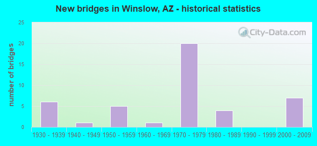
- New bridges - historical statistics
- 61930-1939
- 11940-1949
- 51950-1959
- 11960-1969
- 201970-1979
- 41980-1989
- 72000-2009

- Reconstructed bridges - Historical Statistics
- 11930-1939
- 11940-1949
- 11950-1959
- 01960-1969
- 11970-1979
- 01980-1989
- 01990-1999
- 82000-2009
- 12010-2019


- Bridge Condition - Deck
- 6.3%Very good
- 56.3%Good
- 31.3%Satisfactory
- 6.3%Fair

- Bridge Condition - Superstructure
- 6.3%Very good
- 50.0%Good
- 37.5%Satisfactory
- 6.3%Fair

- Bridge Condition - Substructure
- 6.3%Very good
- 62.5%Good
- 25.0%Satisfactory
- 6.3%Fair

- Bridge Condition - Channel
- 92.9%Good
- 3.6%Satisfactory
- 3.6%Poor

- Bridge Condition - Culverts
- 5.3%Very good
- 47.4%Good
- 42.1%Satisfactory
- 5.3%Fair
Find on map >> Show street view
Structure Number: N331, Location: 1.2KM N OF N2 (Lat: 35.177722, Lng: -110.716833), Route carried "on" structure: Federal lands road N71, Year Built: 2003, Status: Open, Structure Length: 7.83m (25.69ft), Average Daily Traffic: 100 (year 2021), Truck Traffic: 3%, Average Future Daily Traffic: 117 (year 2039), Design Load: HS 20, Features Intersected: LITTLE COLORADO RIVER
Minimum Vertical Clearance: 30+ m (98+ ft), Kilometerpoint: 1.200, Lanes on structure: 2, Owner: Bureau of Indian Affairs, Approaching Roadway Width: 7.8m (25.6ft), Material/Design: Prestressed concrete continuous, Design/Construction: Stringer/Multi-beam, Number Of Spans In Main Unit: 3, Length of Maximum Span: 26.0m (85.3ft), Curb-To-Curb Width: 7.8m (25.6ft), Out-to-Out Width: 8.9m (29.2ft)
Condition: Deck: Good, Superstructure: Very good, Substructure: Very good, Channel: Poor, Operating Rating: 48.6 metric tons, Method Used To Determine Operating Rating: Allowable Stress (AS), Inventory Rating: 36.8 metric tons, Method Used To Determine Inventory Rating: Allowable Stress (AS), Structural Evaluation: Equal to present desirable criteria, Deck Geometry: Equal to present minimum criteria, Waterway Adequacy: Meets minimum limits, Approach Roadway Alignment: Equal to present desirable criteria, Designated Inspection Frequency: Every 24 months, Inspection Date: November 2021, Deck Structure Type: Concrete Cast-file-Place, Wearing Surface/Protective System: Wearing Surface: Monolithic Concrete, Deck Protection: Epoxy Coated Reinforcing
Find on map >> Show street view
Structure Number: N332, Location: 2.8KM N OF BIA ROUTE N2 (Lat: 35.192889, Lng: -110.713194), Route carried "on" structure: Federal lands road N71, Year Built: 2003, Status: Open, Structure Length: 33.48m (109.84ft), Average Daily Traffic: 100 (year 2019), Truck Traffic: 5%, Average Future Daily Traffic: 117 (year 2039), Design Load: HS 20, Features Intersected: WASH
Minimum Vertical Clearance: 30+ m (98+ ft), Kilometerpoint: 2.800, Lanes on structure: 2, Owner: Bureau of Indian Affairs, Approaching Roadway Width: 7.8m (25.6ft), Material/Design: Prestressed concrete, Design/Construction: Stringer/Multi-beam, Number Of Spans In Main Unit: 11, Length of Maximum Span: 30.7m (100.7ft), Curb-To-Curb Width: 7.8m (25.6ft), Out-to-Out Width: 8.8m (28.9ft)
Condition: Deck: Satisfactory, Superstructure: Good, Substructure: Good, Channel: Good, Operating Rating: 54.7 metric tons, Method Used To Determine Operating Rating: Allowable Stress (AS), Inventory Rating: 37.7 metric tons, Method Used To Determine Inventory Rating: Allowable Stress (AS), Structural Evaluation: Better than present minimum criteria, Deck Geometry: Equal to present minimum criteria, Waterway Adequacy: Equal to present desirable criteria, Approach Roadway Alignment: Equal to present desirable criteria, Designated Inspection Frequency: Every 24 months, Inspection Date: November 2019, Deck Structure Type: Concrete Cast-file-Place, Wearing Surface/Protective System: Deck Protection: Epoxy Coated Reinforcing
Find on map >> Show street view
Structure Number: 178, Location: 1.1 mi W Jct I 17 (Lat: 33.489200, Lng: -112.127500), Route carried "on" structure: US 60, Year Built: 1937, Year Reconstructed: 1963, Status: Open, Structure Length: 1.13m (3.71ft), Average Daily Traffic: 40,757 (year 2018), Truck Traffic: 8%, Average Future Daily Traffic: 40,767 (year 2038), Design Load: HS 20, Features Intersected: Grand Canal
Minimum Vertical Clearance: 10.67m (35.01ft), Kilometerpoint: 256.771, Lanes on structure: 6, Owner: State Highway Agency, Approaching Roadway Width: 25.6m (84.0ft), Skew: 22 degrees, Material/Design: Concrete continuous, Design/Construction: Slab, Number Of Spans In Main Unit: 2, Length of Maximum Span: 5.8m (19.0ft), Curb or Sidewalk Widths: Left: 1.8m (5.9ft), Right: 1.8m (5.9ft), Curb-To-Curb Width: 25.6m (84.0ft), Out-to-Out Width: 30.0m (98.4ft)
Condition: Deck: Satisfactory, Superstructure: Satisfactory, Substructure: Satisfactory, Channel: Good, Operating Rating: 47.2 metric tons, Method Used To Determine Operating Rating: Load Factor (LF), Inventory Rating: 28.1 metric tons, Method Used To Determine Inventory Rating: Load Factor (LF), Structural Evaluation: Equal to present minimum criteria, Deck Geometry: Somewhat better than minimum adequacy, Waterway Adequacy: Equal to present desirable criteria, Approach Roadway Alignment: Equal to present desirable criteria, Designated Inspection Frequency: Every 24 months, Inspection Date: January 2022, Deck Structure Type: Concrete Cast-file-Place, Wearing Surface/Protective System: Wearing Surface: Bituminous
Find on map >> Show street view
Structure Number: 1597, Location: 11.6 mi E Jct SR 99 (Lat: 35.012600, Lng: -110.654800), Route carried "on" structure: Interstate 40, Year Built: 1972, Year Reconstructed: 2014, Status: Open, Structure Length: 30.60m (100.39ft), Average Daily Traffic: 9,276 (year 2020), Truck Traffic: 24%, Average Future Daily Traffic: 9,286 (year 2040), Design Load: HS 20, Features Intersected: Little Colorado River
Minimum Vertical Clearance: 30+ m (98+ ft), Kilometerpoint: 413.521, Lanes on structure: 2, Owner: State Highway Agency, Approaching Roadway Width: 11.6m (38.1ft), Skew: 2 degrees, Material/Design: Prestressed concrete continuous, Design/Construction: Stringer/Multi-beam, Number Of Spans In Main Unit: 13, Length of Maximum Span: 23.5m (77.1ft), Curb-To-Curb Width: 11.6m (38.1ft), Out-to-Out Width: 12.4m (40.7ft)
Condition: Deck: Satisfactory, Superstructure: Satisfactory, Substructure: Satisfactory, Channel: Good, Operating Rating: 74.4 metric tons, Method Used To Determine Operating Rating: Load Factor (LF), Inventory Rating: 34.5 metric tons, Method Used To Determine Inventory Rating: Load Factor (LF), Structural Evaluation: Equal to present minimum criteria, Deck Geometry: Equal to present minimum criteria, Waterway Adequacy: Better than present minimum criteria, Approach Roadway Alignment: Better than present minimum criteria, Designated Inspection Frequency: Every 24 months, Inspection Date: May 2021, Deck Structure Type: Concrete Cast-file-Place, Wearing Surface/Protective System: Wearing Surface: Monolithic Concrete
Find on map >> Show street view
Structure Number: 1777, Location: 2.7 mi W Jct SR 87 (Lat: 35.024544, Lng: -110.682017), Route carried "on" structure: Interstate 40, Year Built: 1979, Year Reconstructed: 2014, Status: Open, Structure Length: 3.44m (11.29ft), Average Daily Traffic: 9,992 (year 2020), Truck Traffic: 24%, Average Future Daily Traffic: 10,002 (year 2040), Design Load: HS 20, Features Intersected: Maple St
Minimum Vertical Clearance: 30+ m (98+ ft), Kilometerpoint: 410.544, Lanes on structure: 2, Lanes under structure: 2, Owner: State Highway Agency, Approaching Roadway Width: 11.6m (38.1ft), Skew: 2 degrees, Material/Design: Concrete continuous, Design/Construction: Tee Beam, Number Of Spans In Main Unit: 3, Length of Maximum Span: 13.7m (44.9ft), Curb-To-Curb Width: 12.8m (42.0ft), Out-to-Out Width: 13.6m (44.6ft)
Condition: Deck: Good, Superstructure: Good, Substructure: Good, Operating Rating: 89.8 metric tons, Method Used To Determine Operating Rating: Load Factor (LF), Inventory Rating: 61.7 metric tons, Method Used To Determine Inventory Rating: Load Factor (LF), Structural Evaluation: Better than present minimum criteria, Deck Geometry: Equal to present desirable criteria, Underclear: Meets minimum limits, Approach Roadway Alignment: Equal to present desirable criteria, Designated Inspection Frequency: Every 24 months, Inspection Date: May 2021, Deck Structure Type: Concrete Cast-file-Place, Wearing Surface/Protective System: Wearing Surface: Monolithic Concrete
Find on map >> Show street view
Structure Number: 1778, Location: 2.7 mi W Jct SR 87 (Lat: 35.024500, Lng: -110.681600), Route carried "on" structure: Interstate 40, Year Built: 1979, Year Reconstructed: 2014, Status: Open, Structure Length: 3.44m (11.29ft), Average Daily Traffic: 9,107 (year 2020), Truck Traffic: 24%, Average Future Daily Traffic: 9,117 (year 2040), Design Load: HS 20, Features Intersected: Maple St
Minimum Vertical Clearance: 30+ m (98+ ft), Kilometerpoint: 410.544, Lanes on structure: 2, Lanes under structure: 2, Owner: State Highway Agency, Approaching Roadway Width: 11.6m (38.1ft), Skew: 2 degrees, Material/Design: Concrete continuous, Design/Construction: Tee Beam, Number Of Spans In Main Unit: 3, Length of Maximum Span: 13.7m (44.9ft), Curb-To-Curb Width: 12.8m (42.0ft), Out-to-Out Width: 13.6m (44.6ft)
Condition: Deck: Good, Superstructure: Good, Substructure: Good, Operating Rating: 72.6 metric tons, Method Used To Determine Operating Rating: Load Factor (LF), Inventory Rating: 43.5 metric tons, Method Used To Determine Inventory Rating: Load Factor (LF), Structural Evaluation: Better than present minimum criteria, Deck Geometry: Equal to present desirable criteria, Underclear: Meets minimum limits, Approach Roadway Alignment: Better than present minimum criteria, Designated Inspection Frequency: Every 24 months, Inspection Date: April 2019, Deck Structure Type: Concrete Cast-file-Place, Wearing Surface/Protective System: Wearing Surface: Monolithic Concrete
Find on map >> Show street view
Structure Number: 1779, Location: 10.3 mi E Jct SR 99 (Lat: 35.017800, Lng: -110.674500), Route carried "on" structure: Interstate 40, Year Built: 1979, Year Reconstructed: 2014, Status: Open, Structure Length: 3.69m (12.11ft), Average Daily Traffic: 9,992 (year 2020), Truck Traffic: 24%, Average Future Daily Traffic: 10,002 (year 2040), Design Load: HS 20, Features Intersected: Transcon Lane
Minimum Vertical Clearance: 30+ m (98+ ft), Kilometerpoint: 411.590, Lanes on structure: 2, Lanes under structure: 3, Owner: State Highway Agency, Approaching Roadway Width: 11.6m (38.1ft), Material/Design: Concrete continuous, Design/Construction: Tee Beam, Number Of Spans In Main Unit: 3, Length of Maximum Span: 17.4m (57.1ft), Curb-To-Curb Width: 12.8m (42.0ft), Out-to-Out Width: 13.6m (44.6ft)
Condition: Deck: Good, Superstructure: Satisfactory, Substructure: Good, Operating Rating: 64.4 metric tons, Method Used To Determine Operating Rating: Load Factor (LF), Inventory Rating: 39.0 metric tons, Method Used To Determine Inventory Rating: Load Factor (LF), Structural Evaluation: Equal to present minimum criteria, Deck Geometry: Equal to present desirable criteria, Underclear: High priority of corrective action, Approach Roadway Alignment: Equal to present desirable criteria, Designated Inspection Frequency: Every 24 months, Inspection Date: May 2021, Deck Structure Type: Concrete Cast-file-Place, Wearing Surface/Protective System: Wearing Surface: Monolithic Concrete
Find on map >> Show street view
Structure Number: 178, Location: 10.3 mi E Jct SR 99 (Lat: 35.018100, Lng: -110.674300), Route carried "on" structure: Interstate 40, Year Built: 1979, Year Reconstructed: 2014, Status: Open, Structure Length: 3.69m (12.11ft), Average Daily Traffic: 9,107 (year 2020), Truck Traffic: 24%, Average Future Daily Traffic: 9,117 (year 2040), Design Load: HS 20, Features Intersected: Transcon Lane
Minimum Vertical Clearance: 30+ m (98+ ft), Kilometerpoint: 411.590, Lanes on structure: 2, Lanes under structure: 3, Owner: State Highway Agency, Approaching Roadway Width: 11.6m (38.1ft), Material/Design: Concrete continuous, Design/Construction: Tee Beam, Number Of Spans In Main Unit: 3, Length of Maximum Span: 17.4m (57.1ft), Curb-To-Curb Width: 12.8m (42.0ft), Out-to-Out Width: 13.6m (44.6ft)
Condition: Deck: Good, Superstructure: Good, Substructure: Good, Operating Rating: 62.6 metric tons, Method Used To Determine Operating Rating: Load Factor (LF), Inventory Rating: 37.2 metric tons, Method Used To Determine Inventory Rating: Load Factor (LF), Structural Evaluation: Better than present minimum criteria, Deck Geometry: Equal to present desirable criteria, Underclear: Meets minimum limits, Approach Roadway Alignment: Better than present minimum criteria, Designated Inspection Frequency: Every 24 months, Inspection Date: May 2021, Deck Structure Type: Concrete Cast-file-Place, Wearing Surface/Protective System: Wearing Surface: Monolithic Concrete
Find on map >> Show street view
Structure Number: 1782, Location: 3.2 mi W Jct SR 87 (Lat: 35.031000, Lng: -110.684900), Route carried "on" structure: Interstate 40, Year Built: 1979, Year Reconstructed: 2014, Status: Open, Structure Length: 5.27m (17.29ft), Average Daily Traffic: 9,107 (year 2020), Truck Traffic: 24%, Average Future Daily Traffic: 9,117 (year 2040), Design Load: HS 20, Features Intersected: Ruby Wash
Minimum Vertical Clearance: 9.14m (29.99ft), Kilometerpoint: 409.803, Lanes on structure: 2, Owner: State Highway Agency, Approaching Roadway Width: 11.6m (38.1ft), Skew: 4 degrees, Material/Design: Prestressed concrete continuous, Design/Construction: Stringer/Multi-beam, Number Of Spans In Main Unit: 3, Length of Maximum Span: 17.1m (56.1ft), Curb-To-Curb Width: 12.8m (42.0ft), Out-to-Out Width: 13.6m (44.6ft)
Condition: Deck: Good, Superstructure: Satisfactory, Substructure: Satisfactory, Channel: Good, Operating Rating: 84.4 metric tons, Method Used To Determine Operating Rating: Load Factor (LF), Inventory Rating: 45.4 metric tons, Method Used To Determine Inventory Rating: Load Factor (LF), Structural Evaluation: Equal to present minimum criteria, Deck Geometry: Equal to present desirable criteria, Waterway Adequacy: Better than present minimum criteria, Approach Roadway Alignment: Better than present minimum criteria, Designated Inspection Frequency: Every 24 months, Inspection Date: May 2021, Deck Structure Type: Concrete Cast-file-Place, Wearing Surface/Protective System: Wearing Surface: Monolithic Concrete
Find on map >> Show street view
Structure Number: 1809, Location: 4.8 mi W Jct SR 87 (Lat: 35.039167, Lng: -110.708414), Route carried "on" structure: Interstate 40, Year Built: 1980, Status: Open, Structure Length: 1.10m (3.61ft), Average Daily Traffic: 9,835 (year 2020), Truck Traffic: 24%, Average Future Daily Traffic: 9,845 (year 2040), Design Load: HS 20, Features Intersected: Cemetery Wash
Minimum Vertical Clearance: 30+ m (98+ ft), Kilometerpoint: 407.277, Lanes on structure: 2, Owner: State Highway Agency, Approaching Roadway Width: 11.6m (38.1ft), Skew: 1 degrees, Material/Design: Concrete continuous, Design/Construction: Slab, Number Of Spans In Main Unit: 2, Length of Maximum Span: 5.2m (17.1ft), Curb-To-Curb Width: 12.8m (42.0ft), Out-to-Out Width: 13.8m (45.3ft)
Condition: Deck: Fair, Superstructure: Fair, Substructure: Good, Channel: Good, Operating Rating: 61.7 metric tons, Method Used To Determine Operating Rating: Load Factor (LF), Inventory Rating: 37.2 metric tons, Method Used To Determine Inventory Rating: Load Factor (LF), Structural Evaluation: Somewhat better than minimum adequacy, Deck Geometry: Equal to present desirable criteria, Waterway Adequacy: Better than present minimum criteria, Approach Roadway Alignment: Equal to present desirable criteria, Designated Inspection Frequency: Every 24 months, Inspection Date: May 2021, Deck Structure Type: Concrete Cast-file-Place, Wearing Surface/Protective System: Wearing Surface: Monolithic Concrete
Find on map >> Show street view
Structure Number: 181, Location: 4.8 mi W Jct SR 87 (Lat: 35.039489, Lng: -110.708350), Route carried "on" structure: Interstate 40, Year Built: 1980, Status: Open, Structure Length: 1.10m (3.61ft), Average Daily Traffic: 8,519 (year 2020), Truck Traffic: 24%, Average Future Daily Traffic: 8,529 (year 2040), Design Load: HS 20, Features Intersected: Cemetery Wash
Minimum Vertical Clearance: 30+ m (98+ ft), Kilometerpoint: 407.277, Lanes on structure: 2, Owner: State Highway Agency, Approaching Roadway Width: 11.6m (38.1ft), Skew: 1 degrees, Material/Design: Concrete continuous, Design/Construction: Slab, Number Of Spans In Main Unit: 2, Length of Maximum Span: 5.2m (17.1ft), Curb-To-Curb Width: 12.8m (42.0ft), Out-to-Out Width: 13.8m (45.3ft)
Condition: Deck: Satisfactory, Superstructure: Satisfactory, Substructure: Good, Channel: Good, Operating Rating: 60.8 metric tons, Method Used To Determine Operating Rating: Load Factor (LF), Inventory Rating: 36.3 metric tons, Method Used To Determine Inventory Rating: Load Factor (LF), Structural Evaluation: Equal to present minimum criteria, Deck Geometry: Equal to present desirable criteria, Waterway Adequacy: Better than present minimum criteria, Approach Roadway Alignment: Equal to present desirable criteria, Designated Inspection Frequency: Every 24 months, Inspection Date: May 2021, Deck Structure Type: Concrete Cast-file-Place, Wearing Surface/Protective System: Wearing Surface: Monolithic Concrete
Find on map >> Show street view
Structure Number: 1829, Location: 1.3 mi W Jct B40 (Lat: 35.039517, Lng: -110.744692), Route carried "on" structure: Spur State highway 40, Year Built: 1975, Year Reconstructed: 2019, Status: Open, Structure Length: 5.70m (18.70ft), Average Daily Traffic: 873 (year 2020), Truck Traffic: 13%, Average Future Daily Traffic: 883 (year 2040), Design Load: HS 20, Features Intersected: BNSF Railroad
Minimum Vertical Clearance: 30+ m (98+ ft), Kilometerpoint: 2.044, Lanes on structure: 2, Owner: State Highway Agency, Approaching Roadway Width: 12.2m (40.0ft), Skew: 3 degrees, Material/Design: Prestressed concrete, Design/Construction: Stringer/Multi-beam, Number Of Spans In Main Unit: 3, Length of Maximum Span: 24.7m (81.0ft), Curb or Sidewalk Widths: Left: 0.0m, Right: 1.8m (5.9ft), Curb-To-Curb Width: 13.4m (44.0ft), Out-to-Out Width: 16.0m (52.5ft)
Condition: Deck: Very good, Superstructure: Good, Substructure: Fair, Operating Rating: 65.3 metric tons, Method Used To Determine Operating Rating: Load Factor (LF), Inventory Rating: 33.6 metric tons, Method Used To Determine Inventory Rating: Load Factor (LF), Structural Evaluation: Somewhat better than minimum adequacy, Deck Geometry: Superior to present desirable criteria, Underclear: Somewhat better than minimum adequacy, Approach Roadway Alignment: Equal to present minimum criteria, Designated Inspection Frequency: Every 24 months, Inspection Date: May 2021, Deck Structure Type: Concrete Cast-file-Place, Wearing Surface/Protective System: Wearing Surface: Monolithic Concrete
Find on map >> Show street view
Structure Number: 2785, Location: 4.2 mi W Jct SR 87 (Lat: 35.039300, Lng: -110.698300), Route carried "on" structure: Interstate 40, Year Built: 2007, Status: Open, Structure Length: 6.92m (22.70ft), Average Daily Traffic: 8,159 (year 2020), Truck Traffic: 24%, Average Future Daily Traffic: 8,169 (year 2040), Design Load: HS 20, Features Intersected: North Park Dr
Minimum Vertical Clearance: 30+ m (98+ ft), Kilometerpoint: 408.130, Lanes on structure: 2, Lanes under structure: 6, Owner: State Highway Agency, Approaching Roadway Width: 12.8m (42.0ft), Material/Design: Prestressed concrete, Design/Construction: Box Beam or Girders - Single/Spread, Number Of Spans In Main Unit: 1, Length of Maximum Span: 67.4m (221.1ft), Curb-To-Curb Width: 13.0m (42.7ft), Out-to-Out Width: 14.0m (45.9ft)
Condition: Deck: Good, Superstructure: Good, Substructure: Good, Operating Rating: 89.8 metric tons, Method Used To Determine Operating Rating: Load Factor (LF), Inventory Rating: 52.6 metric tons, Method Used To Determine Inventory Rating: Load Factor (LF), Structural Evaluation: Better than present minimum criteria, Deck Geometry: Superior to present desirable criteria, Underclear: Superior to present desirable criteria, Approach Roadway Alignment: Better than present minimum criteria, Designated Inspection Frequency: Every 24 months, Inspection Date: May 2021, Deck Structure Type: Concrete Cast-file-Place, Wearing Surface/Protective System: Wearing Surface: Bituminous
Find on map >> Show street view
Structure Number: 2786, Location: 4.2 mi W Jct SR 87 (Lat: 35.039722, Lng: -110.698611), Route carried "on" structure: Interstate 40, Year Built: 2007, Status: Open, Structure Length: 6.92m (22.70ft), Average Daily Traffic: 7,253 (year 2020), Truck Traffic: 24%, Average Future Daily Traffic: 7,263 (year 2040), Design Load: HS 20, Features Intersected: North Park Dr
Minimum Vertical Clearance: 30+ m (98+ ft), Kilometerpoint: 408.130, Lanes on structure: 2, Lanes under structure: 6, Owner: State Highway Agency, Approaching Roadway Width: 12.8m (42.0ft), Material/Design: Prestressed concrete, Design/Construction: Box Beam or Girders - Single/Spread, Number Of Spans In Main Unit: 1, Length of Maximum Span: 67.4m (221.1ft), Curb-To-Curb Width: 13.0m (42.7ft), Out-to-Out Width: 14.0m (45.9ft)
Condition: Deck: Good, Superstructure: Good, Substructure: Good, Operating Rating: 89.8 metric tons, Method Used To Determine Operating Rating: Load Factor (LF), Inventory Rating: 52.6 metric tons, Method Used To Determine Inventory Rating: Load Factor (LF), Structural Evaluation: Better than present minimum criteria, Deck Geometry: Superior to present desirable criteria, Underclear: Superior to present desirable criteria, Approach Roadway Alignment: Better than present minimum criteria, Designated Inspection Frequency: Every 24 months, Inspection Date: May 2021, Deck Structure Type: Concrete Cast-file-Place, Wearing Surface/Protective System: Wearing Surface: Bituminous
Find on map >> Show street view
Structure Number: 426, Location: 0.6 mi E Jct SR B40 (Lat: 35.010314, Lng: -110.667428), Route carried "on" structure: State highway 87, Year Built: 1954, Status: Open, Structure Length: 1.65m (5.41ft), Average Daily Traffic: 795 (year 2017), Truck Traffic: 8%, Average Future Daily Traffic: 805 (year 2039), Design Load: HS 20, Features Intersected: Wash
Minimum Vertical Clearance: 30+ m (98+ ft), Kilometerpoint: 553.840, Lanes on structure: 2, Owner: State Highway Agency, Approaching Roadway Width: 11.6m (38.1ft), Material/Design: Concrete continuous, Design/Construction: Culvert, Number Of Spans In Main Unit: 5, Length of Maximum Span: 3.0m (9.8ft), Curb or Sidewalk Widths: Left: 0.2m (0.7ft), Right: 0.2m (0.7ft), Curb-To-Curb Width: 13.0m (42.7ft), Out-to-Out Width: 13.7m (44.9ft)
Condition: Channel: Good, Culverts: Good, Operating Rating: 52.6 metric tons, Method Used To Determine Operating Rating: Load Factor (LF), Inventory Rating: 32.7 metric tons, Method Used To Determine Inventory Rating: Load Factor (LF), Structural Evaluation: Better than present minimum criteria, Deck Geometry: Superior to present desirable criteria, Waterway Adequacy: Equal to present desirable criteria, Approach Roadway Alignment: Equal to present desirable criteria, Designated Inspection Frequency: Every 48 months, Inspection Date: May 2019, Deck Structure Type: Concrete Cast-file-Place, Wearing Surface/Protective System: Wearing Surface: Bituminous
Find on map >> Show street view
Structure Number: 4261, Location: 0.6 mi E Jct SR B40 (Lat: 35.010567, Lng: -110.667286), Route carried "on" structure: State highway 87, Year Built: 1954, Status: Open, Structure Length: 1.65m (5.41ft), Average Daily Traffic: 798 (year 2017), Truck Traffic: 8%, Average Future Daily Traffic: 808 (year 2039), Design Load: HS 20, Features Intersected: Wash
Minimum Vertical Clearance: 30+ m (98+ ft), Kilometerpoint: 553.840, Lanes on structure: 2, Owner: State Highway Agency, Approaching Roadway Width: 11.6m (38.1ft), Material/Design: Concrete continuous, Design/Construction: Culvert, Number Of Spans In Main Unit: 5, Length of Maximum Span: 3.0m (9.8ft), Curb or Sidewalk Widths: Left: 0.2m (0.7ft), Right: 0.2m (0.7ft)
Condition: Channel: Good, Culverts: Good, Operating Rating: 63.5 metric tons, Method Used To Determine Operating Rating: Load Factor (LF), Inventory Rating: 38.1 metric tons, Method Used To Determine Inventory Rating: Load Factor (LF), Structural Evaluation: Better than present minimum criteria, Waterway Adequacy: Equal to present desirable criteria, Approach Roadway Alignment: Equal to present desirable criteria, Designated Inspection Frequency: Every 48 months, Inspection Date: May 2019
Find on map >> Show street view
Structure Number: 4262, Location: 0.8 mi E Jct SR B40 (Lat: 35.008739, Lng: -110.663383), Route carried "on" structure: State highway 87, Year Built: 1939, Year Reconstructed: 1954, Status: Open, Structure Length: 1.31m (4.30ft), Average Daily Traffic: 795 (year 2017), Truck Traffic: 8%, Average Future Daily Traffic: 805 (year 2039), Design Load: HS 20, Features Intersected: Wash
Minimum Vertical Clearance: 30+ m (98+ ft), Kilometerpoint: 554.129, Lanes on structure: 2, Owner: State Highway Agency, Approaching Roadway Width: 11.3m (37.1ft), Material/Design: Concrete continuous, Design/Construction: Culvert, Number Of Spans In Main Unit: 4, Length of Maximum Span: 3.0m (9.8ft), Curb-To-Curb Width: 12.5m (41.0ft), Out-to-Out Width: 13.1m (43.0ft)
Condition: Channel: Good, Culverts: Satisfactory, Operating Rating: 49.9 metric tons, Method Used To Determine Operating Rating: Load Factor (LF), Inventory Rating: 32.7 metric tons, Method Used To Determine Inventory Rating: Load Factor (LF), Structural Evaluation: Equal to present minimum criteria, Deck Geometry: Better than present minimum criteria, Waterway Adequacy: Equal to present desirable criteria, Approach Roadway Alignment: Equal to present desirable criteria, Designated Inspection Frequency: Every 48 months, Inspection Date: May 2019, Deck Structure Type: Concrete Cast-file-Place, Wearing Surface/Protective System: Wearing Surface: Bituminous
Find on map >> Show street view
Structure Number: 4263, Location: 0.8 mi E Jct SR B40 (Lat: 35.008997, Lng: -110.663239), Route carried "on" structure: State highway 87, Year Built: 1954, Status: Open, Structure Length: 1.31m (4.30ft), Average Daily Traffic: 798 (year 2017), Truck Traffic: 8%, Average Future Daily Traffic: 808 (year 2039), Design Load: HS 20, Features Intersected: Wash
Minimum Vertical Clearance: 30+ m (98+ ft), Kilometerpoint: 554.129, Lanes on structure: 2, Owner: State Highway Agency, Approaching Roadway Width: 11.6m (38.1ft), Material/Design: Concrete continuous, Design/Construction: Culvert, Number Of Spans In Main Unit: 4, Length of Maximum Span: 3.0m (9.8ft), Curb-To-Curb Width: 12.5m (41.0ft), Out-to-Out Width: 12.8m (42.0ft)
Condition: Channel: Good, Culverts: Good, Operating Rating: 49.9 metric tons, Method Used To Determine Operating Rating: Load Factor (LF), Inventory Rating: 32.7 metric tons, Method Used To Determine Inventory Rating: Load Factor (LF), Structural Evaluation: Better than present minimum criteria, Deck Geometry: Better than present minimum criteria, Waterway Adequacy: Equal to present desirable criteria, Approach Roadway Alignment: Equal to present desirable criteria, Designated Inspection Frequency: Every 48 months, Inspection Date: May 2019, Deck Structure Type: Concrete Cast-file-Place, Wearing Surface/Protective System: Wearing Surface: Bituminous
Find on map >> Show street view
Structure Number: 4677, Location: 0.3 mi S Jct B40 (Lat: 35.018742, Lng: -110.699864), Route carried "on" structure: State highway 87, Year Built: 1944, Year Reconstructed: 2006, Status: Open, Structure Length: 1.31m (4.30ft), Average Daily Traffic: 1,567 (year 2017), Truck Traffic: 8%, Average Future Daily Traffic: 1,577 (year 2039), Design Load: HS 20, Features Intersected: Ice House Channel
Minimum Vertical Clearance: 30+ m (98+ ft), Kilometerpoint: 550.251, Lanes on structure: 3, Owner: State Highway Agency, Approaching Roadway Width: 6.7m (22.0ft), Material/Design: Concrete continuous, Design/Construction: Culvert, Number Of Spans In Main Unit: 4, Length of Maximum Span: 3.0m (9.8ft)
Condition: Channel: Good, Culverts: Good, Operating Rating: 63.5 metric tons, Method Used To Determine Operating Rating: Load Factor (LF), Inventory Rating: 38.1 metric tons, Method Used To Determine Inventory Rating: Load Factor (LF), Structural Evaluation: Better than present minimum criteria, Waterway Adequacy: Equal to present desirable criteria, Approach Roadway Alignment: Equal to present desirable criteria, Designated Inspection Frequency: Every 48 months, Inspection Date: May 2019
Find on map >> Show street view
Structure Number: 6484, Location: 1.0 mi S Jct I-40 (Lat: 35.007600, Lng: -110.703700), Route carried "on" structure: State highway 87, Year Built: 1970, Status: Open, Structure Length: 1.58m (5.18ft), Average Daily Traffic: 1,567 (year 2017), Truck Traffic: 8%, Average Future Daily Traffic: 1,577 (year 2039), Design Load: HS 20, Features Intersected: Ruby Wash
Minimum Vertical Clearance: 30+ m (98+ ft), Kilometerpoint: 549.076, Lanes on structure: 2, Owner: State Highway Agency, Approaching Roadway Width: 13.1m (43.0ft), Material/Design: Steel, Design/Construction: Culvert, Number Of Spans In Main Unit: 4, Length of Maximum Span: 3.0m (9.8ft)
Condition: Channel: Good, Culverts: Satisfactory, Operating Rating: 89.8 metric tons, Method Used To Determine Operating Rating: Load Factor (LF), Inventory Rating: 89.8 metric tons, Method Used To Determine Inventory Rating: Load Factor (LF), Structural Evaluation: Equal to present minimum criteria, Waterway Adequacy: Equal to present desirable criteria, Approach Roadway Alignment: Equal to present desirable criteria, Designated Inspection Frequency: Every 48 months, Inspection Date: May 2019
Find on map >> Show street view
Structure Number: 6691, Location: 4.5 mi W Jct SR 87 (Lat: 35.039450, Lng: -110.702792), Route carried "on" structure: Interstate 40, Year Built: 1979, Status: Open, Structure Length: 1.34m (4.40ft), Average Daily Traffic: 18,193 (year 2017), Truck Traffic: 24%, Average Future Daily Traffic: 18,203 (year 2039), Design Load: HS 20+Mod, Features Intersected: Drainage Channel
Minimum Vertical Clearance: 30+ m (98+ ft), Kilometerpoint: 407.599, Lanes on structure: 6, Owner: State Highway Agency, Approaching Roadway Width: 23.2m (76.1ft), Skew: 20 degrees, Material/Design: Concrete continuous, Design/Construction: Culvert, Number Of Spans In Main Unit: 4, Length of Maximum Span: 3.0m (9.8ft)
Condition: Channel: Good, Culverts: Satisfactory, Operating Rating: 89.8 metric tons, Method Used To Determine Operating Rating: Load Factor (LF), Inventory Rating: 89.8 metric tons, Method Used To Determine Inventory Rating: Load Factor (LF), Structural Evaluation: Equal to present minimum criteria, Waterway Adequacy: Better than present minimum criteria, Approach Roadway Alignment: Equal to present desirable criteria, Length Of Structure Improvement: 2.10m (6.89ft), Designated Inspection Frequency: Every 48 months, Inspection Date: April 2019, Bridge Improvement Cost: $1,000, Total Project Cost: $2,000 ( Estimate for 2019)
Find on map >> Show street view
Structure Number: 6692, Location: 8.4 mi E Jct SR 99 (Lat: 35.038847, Lng: -110.693389), Route carried "on" structure: Interstate 40, Year Built: 1979, Year Reconstructed: 2005, Status: Open, Structure Length: 1.34m (4.40ft), Average Daily Traffic: 19,999 (year 2017), Truck Traffic: 24%, Average Future Daily Traffic: 20,009 (year 2039), Design Load: HS 20+Mod, Features Intersected: Channel A
Minimum Vertical Clearance: 30+ m (98+ ft), Kilometerpoint: 408.452, Lanes on structure: 8, Owner: State Highway Agency, Approaching Roadway Width: 46.9m (153.9ft), Skew: 20 degrees, Material/Design: Concrete continuous, Design/Construction: Culvert, Number Of Spans In Main Unit: 4, Length of Maximum Span: 3.0m (9.8ft)
Condition: Channel: Good, Culverts: Satisfactory, Operating Rating: 89.8 metric tons, Method Used To Determine Operating Rating: Load Factor (LF), Inventory Rating: 89.8 metric tons, Method Used To Determine Inventory Rating: Load Factor (LF), Structural Evaluation: Equal to present minimum criteria, Waterway Adequacy: Better than present minimum criteria, Approach Roadway Alignment: Equal to present desirable criteria, Length Of Structure Improvement: 2.10m (6.89ft), Designated Inspection Frequency: Every 48 months, Inspection Date: April 2019, Bridge Improvement Cost: $2,000, Roadway Improvement Cost: $1,000, Total Project Cost: $3,000 ( Estimate for 2019)
Find on map >> Show street view
Structure Number: 6693, Location: 2.4 mi W Jct SR 87 (Lat: 35.020497, Lng: -110.678667), Route carried "on" structure: Interstate 40, Year Built: 1979, Status: Open, Structure Length: 1.28m (4.20ft), Average Daily Traffic: 19,999 (year 2017), Truck Traffic: 24%, Average Future Daily Traffic: 20,009 (year 2039), Design Load: HS 20+Mod, Features Intersected: Wash
Minimum Vertical Clearance: 30+ m (98+ ft), Kilometerpoint: 410.978, Lanes on structure: 6, Owner: State Highway Agency, Approaching Roadway Width: 11.6m (38.1ft), Material/Design: Concrete continuous, Design/Construction: Culvert, Number Of Spans In Main Unit: 4, Length of Maximum Span: 3.0m (9.8ft)
Condition: Channel: Good, Culverts: Good, Operating Rating: 89.8 metric tons, Method Used To Determine Operating Rating: Load Factor (LF), Inventory Rating: 89.8 metric tons, Method Used To Determine Inventory Rating: Load Factor (LF), Structural Evaluation: Better than present minimum criteria, Waterway Adequacy: Better than present minimum criteria, Approach Roadway Alignment: Equal to present desirable criteria, Length Of Structure Improvement: 2.04m (6.69ft), Designated Inspection Frequency: Every 48 months, Inspection Date: April 2019, Bridge Improvement Cost: $1,000, Total Project Cost: $2,000 ( Estimate for 2019)
Find on map >> Show street view
Structure Number: 6717, Location: 6.1 mi E Jct SR 99 (Lat: 35.038789, Lng: -110.734203), Route carried "on" structure: Interstate 40, Year Built: 1974, Status: Open, Structure Length: 1.62m (5.31ft), Average Daily Traffic: 17,842 (year 2017), Truck Traffic: 24%, Average Future Daily Traffic: 17,852 (year 2039), Design Load: HS 20, Features Intersected: Wash
Minimum Vertical Clearance: 30+ m (98+ ft), Kilometerpoint: 404.686, Lanes on structure: 8, Owner: State Highway Agency, Approaching Roadway Width: 46.3m (151.9ft), Skew: 1 degrees, Material/Design: Concrete continuous, Design/Construction: Culvert, Number Of Spans In Main Unit: 5, Length of Maximum Span: 3.0m (9.8ft)
Condition: Channel: Good, Culverts: Good, Operating Rating: 89.8 metric tons, Method Used To Determine Operating Rating: Load Factor (LF), Inventory Rating: 89.8 metric tons, Method Used To Determine Inventory Rating: Load Factor (LF), Structural Evaluation: Better than present minimum criteria, Waterway Adequacy: Equal to present desirable criteria, Approach Roadway Alignment: Equal to present desirable criteria, Length Of Structure Improvement: 2.38m (7.81ft), Designated Inspection Frequency: Every 48 months, Inspection Date: April 2019, Bridge Improvement Cost: $1,000, Roadway Improvement Cost: $1,000, Total Project Cost: $3,000 ( Estimate for 2019)
Find on map >> Show street view
Structure Number: 7229, Location: 0.4 mi S Jct I-40 (Lat: 35.017781, Lng: -110.700344), Route carried "on" structure: State highway 87, Year Built: 2006, Status: Open, Structure Length: 3.93m (12.89ft), Average Daily Traffic: 1,567 (year 2017), Truck Traffic: 8%, Average Future Daily Traffic: 1,577 (year 2039), Design Load: HS 20, Features Intersected: Ruby Channel
Minimum Vertical Clearance: 30+ m (98+ ft), Kilometerpoint: 550.106, Lanes on structure: 2, Owner: State Highway Agency, Approaching Roadway Width: 13.4m (44.0ft), Skew: 3 degrees, Material/Design: Steel, Design/Construction: Culvert, Number Of Spans In Main Unit: 14, Length of Maximum Span: 1.2m (3.9ft)
Condition: Channel: Good, Culverts: Very good, Operating Rating: 65.3 metric tons, Method Used To Determine Operating Rating: Load Factor (LF), Inventory Rating: 39.0 metric tons, Method Used To Determine Inventory Rating: Load Factor (LF), Structural Evaluation: Equal to present desirable criteria, Waterway Adequacy: Equal to present desirable criteria, Approach Roadway Alignment: Equal to present desirable criteria, Designated Inspection Frequency: Every 48 months, Inspection Date: May 2019
Find on map >> Show street view
Structure Number: 9495, Location: 0.3 mi W Jct N Park Dr (Lat: 35.034500, Lng: -110.702700), Route carried "on" structure: City street , Year Built: 1965, Status: Open, Structure Length: 0.79m (2.59ft), Average Daily Traffic: 900 (year 2018), Truck Traffic: 1%, Average Future Daily Traffic: 910 (year 2038), Design Load: HS 20, Features Intersected: Ditch, Facility Carried by Structure: Hillview Street
Minimum Vertical Clearance: 30+ m (98+ ft), Kilometerpoint: 0.000, Lanes on structure: 2, Owner: City or Municipal Highway Agency, Approaching Roadway Width: 11.9m (39.0ft), Material/Design: Concrete continuous, Design/Construction: Culvert, Number Of Spans In Main Unit: 3, Length of Maximum Span: 2.4m (7.9ft)
Condition: Channel: Good, Culverts: Satisfactory, Operating Rating: 74.4 metric tons, Method Used To Determine Operating Rating: Load Factor (LF), Inventory Rating: 44.5 metric tons, Method Used To Determine Inventory Rating: Load Factor (LF), Structural Evaluation: Equal to present minimum criteria, Waterway Adequacy: Better than present minimum criteria, Approach Roadway Alignment: Better than present minimum criteria, Designated Inspection Frequency: Every 48 months, Inspection Date: June 2018
Find on map >> Show street view
Structure Number: 9498, Location: 100 ft W Jct Douglas Ave (Lat: 35.029000, Lng: -110.704300), Route carried "on" structure: City street , Year Built: 1977, Status: Open, Structure Length: 0.79m (2.59ft), Average Daily Traffic: 800 (year 2018), Truck Traffic: 1%, Average Future Daily Traffic: 810 (year 2038), Design Load: HS 20, Features Intersected: Wash, Facility Carried by Structure: Aspinwall Street
Minimum Vertical Clearance: 30+ m (98+ ft), Kilometerpoint: 0.000, Lanes on structure: 2, Owner: City or Municipal Highway Agency, Approaching Roadway Width: 11.6m (38.1ft), Material/Design: Concrete continuous, Design/Construction: Culvert, Number Of Spans In Main Unit: 3, Length of Maximum Span: 2.4m (7.9ft), Curb or Sidewalk Widths: Left: 0.0m, Right: 1.5m (4.9ft), Curb-To-Curb Width: 11.6m (38.1ft), Out-to-Out Width: 14.0m (45.9ft)
Condition: Channel: Good, Culverts: Good, Operating Rating: 49.0 metric tons, Method Used To Determine Operating Rating: Load Factor (LF), Inventory Rating: 29.0 metric tons, Method Used To Determine Inventory Rating: Load Factor (LF), Structural Evaluation: Better than present minimum criteria, Deck Geometry: Better than present minimum criteria, Waterway Adequacy: Better than present minimum criteria, Approach Roadway Alignment: Better than present minimum criteria, Designated Inspection Frequency: Every 48 months, Inspection Date: June 2018, Deck Structure Type: Concrete Cast-file-Place, Wearing Surface/Protective System: Wearing Surface: Bituminous
Find on map >> Show street view
Structure Number: 9899, Location: 0.8 mi N Jct I-40 (Lat: 35.052400, Lng: -110.698100), Route carried "on" structure: City street , Year Built: 1981, Status: Open, Structure Length: 11.46m (37.60ft), Average Daily Traffic: 2,500 (year 2020), Truck Traffic: 5%, Average Future Daily Traffic: 2,510 (year 2040), Design Load: HS 20, Features Intersected: Channel A, Facility Carried by Structure: North Park Drive
Minimum Vertical Clearance: 30+ m (98+ ft), Kilometerpoint: 0.000, Lanes on structure: 2, Owner: City or Municipal Highway Agency, Approaching Roadway Width: 11.6m (38.1ft), Skew: 3 degrees, Material/Design: Concrete continuous, Design/Construction: Slab, Number Of Spans In Main Unit: 11, Length of Maximum Span: 10.7m (35.1ft), Curb-To-Curb Width: 11.6m (38.1ft), Out-to-Out Width: 12.6m (41.3ft)
Condition: Deck: Satisfactory, Superstructure: Satisfactory, Substructure: Satisfactory, Channel: Good, Operating Rating: 85.3 metric tons, Method Used To Determine Operating Rating: Load Factor (LF), Inventory Rating: 50.8 metric tons, Method Used To Determine Inventory Rating: Load Factor (LF), Structural Evaluation: Equal to present minimum criteria, Deck Geometry: Somewhat better than minimum adequacy, Waterway Adequacy: Equal to present desirable criteria, Approach Roadway Alignment: Equal to present desirable criteria, Designated Inspection Frequency: Every 24 months, Inspection Date: June 2020, Deck Structure Type: Concrete Cast-file-Place, Wearing Surface/Protective System: Wearing Surface: Monolithic Concrete
Find on map >> Show street view
Structure Number: 99, Location: 0.5 mi E Jct North Prk Dr (Lat: 35.038922, Lng: -110.690328), Route carried "on" structure: City street , Year Built: 1979, Status: Open, Structure Length: 3.96m (12.99ft), Average Daily Traffic: 1,600 (year 2020), Truck Traffic: 5%, Average Future Daily Traffic: 1,610 (year 2040), Design Load: HS 20, Features Intersected: Ruby Drain, Facility Carried by Structure: North Road
Minimum Vertical Clearance: 7.62m (25.00ft), Kilometerpoint: 0.000, Lanes on structure: 2, Owner: City or Municipal Highway Agency, Approaching Roadway Width: 7.9m (25.9ft), Skew: 1 degrees, Material/Design: Concrete continuous, Design/Construction: Slab, Number Of Spans In Main Unit: 4, Length of Maximum Span: 10.7m (35.1ft), Curb-To-Curb Width: 7.9m (25.9ft), Out-to-Out Width: 8.7m (28.5ft)
Condition: Deck: Good, Superstructure: Good, Substructure: Good, Channel: Good, Operating Rating: 85.3 metric tons, Method Used To Determine Operating Rating: Load Factor (LF), Inventory Rating: 50.8 metric tons, Method Used To Determine Inventory Rating: Load Factor (LF), Structural Evaluation: Better than present minimum criteria, Deck Geometry: Meets minimum limits, Waterway Adequacy: Equal to present desirable criteria, Approach Roadway Alignment: Equal to present desirable criteria, Designated Inspection Frequency: Every 24 months, Inspection Date: June 2020, Deck Structure Type: Concrete Cast-file-Place, Wearing Surface/Protective System: Wearing Surface: Monolithic Concrete
Find on map >> Show street view
Structure Number: 9903, Location: 300 ft E Jct Pope Ave (Lat: 35.024900, Lng: -110.688100), Route carried "on" structure: City street , Year Built: 1987, Status: Open, Structure Length: 2.29m (7.51ft), Average Daily Traffic: 1,540 (year 2018), Truck Traffic: 1%, Average Future Daily Traffic: 1,550 (year 2038), Design Load: HS 20, Features Intersected: Ruby Wash, Facility Carried by Structure: Maple Street
Minimum Vertical Clearance: 10.67m (35.01ft), Kilometerpoint: 0.000, Lanes on structure: 2, Owner: City or Municipal Highway Agency, Approaching Roadway Width: 7.3m (24.0ft), Material/Design: Concrete continuous, Design/Construction: Culvert, Number Of Spans In Main Unit: 7, Length of Maximum Span: 3.0m (9.8ft), Curb or Sidewalk Widths: Left: 0.0m, Right: 1.5m (4.9ft)
Condition: Channel: Good, Culverts: Good, Operating Rating: 49.9 metric tons, Method Used To Determine Operating Rating: Load Factor (LF), Inventory Rating: 29.9 metric tons, Method Used To Determine Inventory Rating: Load Factor (LF), Structural Evaluation: Better than present minimum criteria, Waterway Adequacy: Better than present minimum criteria, Approach Roadway Alignment: Better than present minimum criteria, Designated Inspection Frequency: Every 48 months, Inspection Date: June 2018, Deck Structure Type: Concrete Cast-file-Place, Wearing Surface/Protective System: Wearing Surface: Monolithic Concrete
Find on map >> Show street view
Structure Number: 1097, Location: 0.6 mi W Jct SR 87 (Lat: 35.026325, Lng: -110.705781), Route carried "on" structure: City street , Year Built: 1934, Status: Open, Structure Length: 0.76m (2.49ft), Average Daily Traffic: 7,400 (year 2020), Truck Traffic: 7%, Average Future Daily Traffic: 7,410 (year 2040), Design Load: HS 15, Features Intersected: Icehouse Wash, Facility Carried by Structure: W. 2nd Street
Minimum Vertical Clearance: 30+ m (98+ ft), Kilometerpoint: 1.609, Lanes on structure: 2, Owner: City or Municipal Highway Agency, Approaching Roadway Width: 12.2m (40.0ft), Material/Design: Concrete continuous, Design/Construction: Culvert, Number Of Spans In Main Unit: 2, Length of Maximum Span: 3.7m (12.1ft), Curb or Sidewalk Widths: Left: 2.1m (6.9ft), Right: 2.1m (6.9ft), Curb-To-Curb Width: 12.2m (40.0ft), Out-to-Out Width: 16.5m (54.1ft)
Condition: Channel: Satisfactory, Culverts: Satisfactory, Operating Rating: 53.5 metric tons, Method Used To Determine Operating Rating: Load Factor (LF), Inventory Rating: 31.8 metric tons, Method Used To Determine Inventory Rating: Load Factor (LF), Structural Evaluation: Equal to present minimum criteria, Deck Geometry: Better than present minimum criteria, Waterway Adequacy: Equal to present minimum criteria, Approach Roadway Alignment: Equal to present desirable criteria, Designated Inspection Frequency: Every 48 months, Inspection Date: June 2020, Deck Structure Type: Concrete Cast-file-Place, Wearing Surface/Protective System: Wearing Surface: Bituminous
Find on map >> Show street view
Structure Number: 10971, Location: 0.6 mi W Jct SR 87 (Lat: 35.027222, Lng: -110.705269), Route carried "on" structure: City street , Year Built: 1953, Status: Open, Structure Length: 0.82m (2.69ft), Average Daily Traffic: 7,400 (year 2020), Truck Traffic: 7%, Average Future Daily Traffic: 7,410 (year 2040), Design Load: HS 20, Features Intersected: Ice House Wash, Facility Carried by Structure: W. 3rd Street
Minimum Vertical Clearance: 30+ m (98+ ft), Kilometerpoint: 1.609, Lanes on structure: 2, Owner: City or Municipal Highway Agency, Approaching Roadway Width: 13.1m (43.0ft), Material/Design: Concrete continuous, Design/Construction: Culvert, Number Of Spans In Main Unit: 2, Length of Maximum Span: 3.7m (12.1ft), Curb or Sidewalk Widths: Left: 2.3m (7.5ft), Right: 2.3m (7.5ft), Curb-To-Curb Width: 13.1m (43.0ft), Out-to-Out Width: 18.3m (60.0ft)
Condition: Channel: Good, Culverts: Good, Operating Rating: 52.6 metric tons, Method Used To Determine Operating Rating: Load Factor (LF), Inventory Rating: 31.8 metric tons, Method Used To Determine Inventory Rating: Load Factor (LF), Structural Evaluation: Better than present minimum criteria, Deck Geometry: Superior to present desirable criteria, Waterway Adequacy: Better than present minimum criteria, Approach Roadway Alignment: Equal to present desirable criteria, Designated Inspection Frequency: Every 48 months, Inspection Date: June 2020, Deck Structure Type: Concrete Cast-file-Place, Wearing Surface/Protective System: Wearing Surface: Bituminous
Find on map >> Show street view
Structure Number: 10972, Location: 0.4 mi E Jct SR 87 South (Lat: 35.020589, Lng: -110.690678), Route carried "on" structure: City street , Year Built: 1932, Year Reconstructed: 1938, Status: Open, Structure Length: 3.44m (11.29ft), Average Daily Traffic: 7,400 (year 2020), Truck Traffic: 7%, Average Future Daily Traffic: 7,410 (year 2040), Design Load: H 15, Features Intersected: Ruby Wash, Facility Carried by Structure: 2nd Street
Minimum Vertical Clearance: 30+ m (98+ ft), Kilometerpoint: 1.609, Lanes on structure: 3, Owner: City or Municipal Highway Agency, Approaching Roadway Width: 18.3m (60.0ft), Skew: 1 degrees, Material/Design: Concrete continuous, Design/Construction: Culvert, Number Of Spans In Main Unit: 10, Length of Maximum Span: 3.0m (9.8ft), Curb or Sidewalk Widths: Left: 1.2m (3.9ft), Right: 1.2m (3.9ft), Curb-To-Curb Width: 18.3m (60.0ft), Out-to-Out Width: 21.2m (69.6ft)
Condition: Channel: Good, Culverts: Fair, Operating Rating: 49.0 metric tons, Method Used To Determine Operating Rating: Load Factor (LF), Inventory Rating: 29.0 metric tons, Method Used To Determine Inventory Rating: Load Factor (LF), Structural Evaluation: Somewhat better than minimum adequacy, Deck Geometry: Superior to present desirable criteria, Waterway Adequacy: Better than present minimum criteria, Approach Roadway Alignment: Equal to present desirable criteria, Designated Inspection Frequency: Every 24 months, Inspection Date: June 2020, Deck Structure Type: Concrete Cast-file-Place, Wearing Surface/Protective System: Wearing Surface: Bituminous, Membrane: Other
Find on map >> Show street view
Structure Number: 10973, Location: 0.4 mi W Jct SR 87 (Lat: 35.021386, Lng: -110.690189), Route carried "on" structure: City street , Year Built: 1953, Status: Open, Structure Length: 3.29m (10.79ft), Average Daily Traffic: 7,400 (year 2020), Truck Traffic: 7%, Average Future Daily Traffic: 7,410 (year 2040), Design Load: HS 20, Features Intersected: Ruby Wash, Facility Carried by Structure: E 3rd Street
Minimum Vertical Clearance: 30+ m (98+ ft), Kilometerpoint: 1.609, Lanes on structure: 2, Owner: City or Municipal Highway Agency, Approaching Roadway Width: 13.1m (43.0ft), Material/Design: Concrete continuous, Design/Construction: Culvert, Number Of Spans In Main Unit: 10, Length of Maximum Span: 3.0m (9.8ft), Curb or Sidewalk Widths: Left: 1.6m (5.2ft), Right: 2.9m (9.5ft), Curb-To-Curb Width: 13.1m (43.0ft), Out-to-Out Width: 18.3m (60.0ft)
Condition: Channel: Good, Culverts: Satisfactory, Operating Rating: 53.5 metric tons, Method Used To Determine Operating Rating: Load Factor (LF), Inventory Rating: 31.8 metric tons, Method Used To Determine Inventory Rating: Load Factor (LF), Structural Evaluation: Equal to present minimum criteria, Deck Geometry: Superior to present desirable criteria, Waterway Adequacy: Equal to present minimum criteria, Approach Roadway Alignment: Equal to present desirable criteria, Designated Inspection Frequency: Every 48 months, Inspection Date: June 2020, Deck Structure Type: Concrete Cast-file-Place, Wearing Surface/Protective System: Wearing Surface: Bituminous
Find on map >> Show street view
Structure Number: 10974, Location: 1.2 mi W Jct SR 87 (Lat: 35.014625, Lng: -110.678167), Route carried "on" structure: City street , Year Built: 1939, Year Reconstructed: 1978, Status: Open, Structure Length: 0.64m (2.10ft), Average Daily Traffic: 7,400 (year 2020), Truck Traffic: 7%, Average Future Daily Traffic: 7,410 (year 2040), Design Load: HS 20, Features Intersected: Wash, Facility Carried by Structure: Main
Minimum Vertical Clearance: 30+ m (98+ ft), Kilometerpoint: 1.609, Lanes on structure: 4, Owner: City or Municipal Highway Agency, Approaching Roadway Width: 19.5m (64.0ft), Skew: 20 degrees, Material/Design: Concrete continuous, Design/Construction: Culvert, Number Of Spans In Main Unit: 2, Length of Maximum Span: 3.0m (9.8ft)
Condition: Channel: Good, Culverts: Satisfactory, Operating Rating: 64.4 metric tons, Method Used To Determine Operating Rating: Load Factor (LF), Inventory Rating: 38.1 metric tons, Method Used To Determine Inventory Rating: Load Factor (LF), Structural Evaluation: Equal to present minimum criteria, Waterway Adequacy: Better than present minimum criteria, Approach Roadway Alignment: Equal to present desirable criteria, Designated Inspection Frequency: Every 48 months, Inspection Date: June 2020
Find on map >> Show street view
Structure Number: 194, Location: 0.1 mi S Jct B40 (Lat: 35.021536, Lng: -110.697672), Route carried "under" structure: State highway 87, Year Built: 1936, Structure Length: 0. m, Average Daily Traffic: 1,884 (year 2019), Truck Traffic: 10%, Features Intersected: SR 87; FAP 073, Facility Carried by Structure: BNSF RR
Minimum Vertical Clearance: 4.55m (14.93ft), Kilometerpoint: 550.557, Lanes under structure: 2, Material/Design: Concrete continuous, Design/Construction: Frame, Length of Maximum Span: 8.2m (26.9ft)
Find on map >> Show street view
Structure Number: 1598, Location: Jct I-40 (Lat: 35.008500, Lng: -110.641800), Route carried "under" structure: Interstate 40, Year Built: 1972, Structure Length: 0. m, Average Daily Traffic: 18,496 (year 2019), Truck Traffic: 34%, Features Intersected: I-40, Facility Carried by Structure: IRR SR 87
Minimum Vertical Clearance: 5.02m (16.47ft), Kilometerpoint: 414.921, Lanes on structure: 2, Lanes under structure: 2, Material/Design: Concrete continuous, Design/Construction: Box Beam or Girders - Single/Spread, Length of Maximum Span: 37.5m (123.0ft)
Find on map >> Show street view
Structure Number: 165, Location: 1.3 mi W Jct SR 87 (Lat: 35.037500, Lng: -110.724200), Route carried "under" structure: Interstate 40, Year Built: 1974, Structure Length: 0. m, Average Daily Traffic: 17,038 (year 2020), Truck Traffic: 24%, Features Intersected: I-40, Facility Carried by Structure: Hipkoe Drive
Minimum Vertical Clearance: 5.85m (19.19ft), Kilometerpoint: 405.748, Lanes on structure: 3, Lanes under structure: 3, Material/Design: Concrete continuous, Design/Construction: Box Beam or Girders - Single/Spread, Length of Maximum Span: 32.9m (107.9ft)
Find on map >> Show street view
Structure Number: 1777, Location: 2.7 mi W Jct SR 87 (Lat: 35.024544, Lng: -110.682017), Route carried "under" structure: City street , Year Built: 1979, Structure Length: 0. m, Average Daily Traffic: 250 (year 2021), Truck Traffic: 10%, Features Intersected: Maple St, Facility Carried by Structure: I-40 EB
Minimum Vertical Clearance: 5.00m (16.40ft), Kilometerpoint: 0.000, Lanes on structure: 2, Lanes under structure: 2, Material/Design: Concrete continuous, Design/Construction: Tee Beam, Length of Maximum Span: 13.7m (44.9ft)
Find on map >> Show street view
Structure Number: 1778, Location: 2.7 mi W Jct SR 87 (Lat: 35.024500, Lng: -110.681600), Route carried "under" structure: City street , Year Built: 1979, Structure Length: 0. m, Average Daily Traffic: 250 (year 2021), Truck Traffic: 10%, Features Intersected: Maple St, Facility Carried by Structure: I-40 WB
Minimum Vertical Clearance: 4.63m (15.19ft), Kilometerpoint: 0.000, Lanes on structure: 2, Lanes under structure: 2, Material/Design: Concrete continuous, Design/Construction: Tee Beam, Length of Maximum Span: 13.7m (44.9ft)
Find on map >> Show street view
Structure Number: 1779, Location: 10.3 mi E Jct SR 99 (Lat: 35.017800, Lng: -110.674500), Route carried "under" structure: City street , Year Built: 1979, Structure Length: 0. m, Average Daily Traffic: 4,640 (year 2020), Truck Traffic: 20%, Features Intersected: Transcon Lane, Facility Carried by Structure: I-40 EB
Minimum Vertical Clearance: 5.36m (17.59ft), Kilometerpoint: 0.000, Lanes on structure: 2, Lanes under structure: 2, Material/Design: Concrete continuous, Design/Construction: Tee Beam, Length of Maximum Span: 17.4m (57.1ft)
Find on map >> Show street view
Structure Number: 178, Location: 10.3 mi E Jct SR 99 (Lat: 35.018100, Lng: -110.674300), Route carried "under" structure: City street , Year Built: 1979, Structure Length: 0. m, Average Daily Traffic: 4,640 (year 2020), Truck Traffic: 20%, Features Intersected: Transcon Lane, Facility Carried by Structure: I-40 WB
Minimum Vertical Clearance: 5.07m (16.63ft), Kilometerpoint: 0.000, Lanes on structure: 2, Lanes under structure: 2, Material/Design: Concrete continuous, Design/Construction: Tee Beam, Length of Maximum Span: 17.4m (57.1ft)
Find on map >> Show street view
Structure Number: 2785, Location: 4.2 mi W Jct SR 87 (Lat: 35.039300, Lng: -110.698300), Route carried "under" structure: City street , Year Built: 2007, Structure Length: 0. m, Average Daily Traffic: 7,220 (year 2019), Truck Traffic: 7%, Features Intersected: North Park Dr, Facility Carried by Structure: I-40 EB
Minimum Vertical Clearance: 5.31m (17.42ft), Kilometerpoint: 0.000, Lanes on structure: 2, Lanes under structure: 2, Material/Design: Prestressed concrete, Design/Construction: Box Beam or Girders - Single/Spread, Length of Maximum Span: 67.4m (221.1ft)
Find on map >> Show street view
Structure Number: 2786, Location: 4.2 mi W Jct SR 87 (Lat: 35.039722, Lng: -110.698611), Route carried "under" structure: City street , Year Built: 2007, Structure Length: 0. m, Average Daily Traffic: 7,220 (year 2019), Truck Traffic: 7%, Features Intersected: North Park Dr, Facility Carried by Structure: I-40 WB
Minimum Vertical Clearance: 5.33m (17.49ft), Kilometerpoint: 0.000, Lanes on structure: 2, Lanes under structure: 2, Material/Design: Prestressed concrete, Design/Construction: Box Beam or Girders - Single/Spread, Length of Maximum Span: 67.4m (221.1ft)