Bridge Statistics for Winston, Missouri (MO)
Condition, Traffic, Stress, Structural Evaluation, Project Costs
- National Bridge Inventory (NBI) Statistics
- 12Number of bridges
- 69ft / 21.3mTotal length
- $1,473,000Total costs
- 56,472Total average daily traffic
- 14,865Total average daily truck traffic
- National Bridge Inventory (NBI) Registered Bridges for Winston
- No street view available for this location
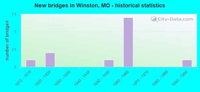
- New bridges - historical statistics
- 11910-1919
- 21920-1929
- 11950-1959
- 71960-1969
- 11990-1999

- Reconstructed bridges - Historical Statistics
- 11950-1959
- 01960-1969
- 01970-1979
- 01980-1989
- 21990-1999
- 12000-2009


- Bridge Condition - Deck
- 16.7%Good
- 16.7%Satisfactory
- 50.0%Fair
- 16.7%Poor

- Bridge Condition - Superstructure
- 16.7%Good
- 33.3%Satisfactory
- 33.3%Fair
- 16.7%Poor

- Bridge Condition - Substructure
- 16.7%Good
- 66.7%Satisfactory
- 16.7%Serious

- Bridge Condition - Channel
- 33.3%Satisfactory
- 66.7%Fair

- Bridge Condition - Culverts
- 50.0%Satisfactory
- 50.0%Fair
Find on map >> Show street view
Structure Number: 1086, Location: S 8 T 58 N R 29 W (Lat: 39.853458, Lng: -94.176833), Route carried "on" structure: US 69, Year Built: 1964, Year Reconstructed: 1990, Status: Open, Structure Length: 7.41m (24.31ft), Average Daily Traffic: 3,621 (year 2021), Truck Traffic: 12%, Average Future Daily Traffic: 7,604 (year 2041), Design Load: H 20, Features Intersected: IS 35
Minimum Vertical Clearance: 30+ m (98+ ft), Kilometerpoint: 92.859, Lanes on structure: 2, Lanes under structure: 4, Base Highway Network: Yes, Owner: State Highway Agency, Approaching Roadway Width: 12.2m (40.0ft), Skew: 1 degrees, Material/Design: Concrete continuous, Design/Construction: Slab, Number Of Spans In Main Unit: 4, Length of Maximum Span: 20.7m (67.9ft), Curb-To-Curb Width: 8.5m (27.9ft), Out-to-Out Width: 9.6m (31.5ft)
Condition: Deck: Satisfactory, Superstructure: Satisfactory, Substructure: Satisfactory, Operating Rating: 46.8 metric tons, Method Used To Determine Operating Rating: Load Factor (LF), Inventory Rating: 27.9 metric tons, Method Used To Determine Inventory Rating: Load Factor (LF), Structural Evaluation: Equal to present minimum criteria, Deck Geometry: Meets minimum limits, Underclear: Meets minimum limits, Approach Roadway Alignment: Equal to present desirable criteria, Designated Inspection Frequency: Every 24 months, Inspection Date: November 2021, Deck Structure Type: Concrete Cast-file-Place, Wearing Surface/Protective System: Wearing Surface: Bituminous, Membrane: Built-up
Find on map >> Show street view
Structure Number: 128, Location: S 33 T 59 N R 29 W (Lat: 39.877600, Lng: -94.164906), Route carried "on" structure: Interstate 35, Year Built: 1966, Status: Open, Structure Length: 0.76m (2.49ft), Average Daily Traffic: 18,492 (year 2021), Truck Traffic: 29%, Average Future Daily Traffic: 38,833 (year 2041), Design Load: HS 20, Features Intersected: SMITH BR
Minimum Vertical Clearance: 30+ m (98+ ft), Kilometerpoint: 81.879, Lanes on structure: 4, Base Highway Network: Yes, Owner: State Highway Agency, Approaching Roadway Width: 40.2m (131.9ft), Skew: 22 degrees, Material/Design: Concrete continuous, Design/Construction: Culvert, Number Of Spans In Main Unit: 2, Length of Maximum Span: 3.4m (11.2ft)
Condition: Channel: Fair, Culverts: Satisfactory, Structural Evaluation: Equal to present minimum criteria, Waterway Adequacy: Equal to present minimum criteria, Approach Roadway Alignment: Equal to present desirable criteria, Designated Inspection Frequency: Every 24 months, Inspection Date: January 2022
Find on map >> Show street view
Structure Number: 1281, Location: S 28 T 59 N R 29 W (Lat: 39.899633, Lng: -94.151339), Route carried "on" structure: State highway 6, Year Built: 1966, Year Reconstructed: 1990, Status: Open, Structure Length: 7.50m (24.61ft), Average Daily Traffic: 768 (year 2021), Truck Traffic: 9%, Average Future Daily Traffic: 1,037 (year 2041), Design Load: H 15, Features Intersected: IS 35
Minimum Vertical Clearance: 30+ m (98+ ft), Kilometerpoint: 70.238, Lanes on structure: 2, Lanes under structure: 4, Base Highway Network: Yes, Owner: State Highway Agency, Approaching Roadway Width: 10.4m (34.1ft), Skew: 2 degrees, Material/Design: Steel continuous, Design/Construction: Stringer/Multi-beam, Number Of Spans In Main Unit: 4, Length of Maximum Span: 21.3m (69.9ft), Curb-To-Curb Width: 8.5m (27.9ft), Out-to-Out Width: 9.4m (30.8ft)
Condition: Deck: Poor, Superstructure: Satisfactory, Substructure: Good, Operating Rating: 27.9 metric tons, Method Used To Determine Operating Rating: Load Factor (LF), Inventory Rating: 17.1 metric tons, Method Used To Determine Inventory Rating: Load Factor (LF), Structural Evaluation: Meets minimum limits, Deck Geometry: Somewhat better than minimum adequacy, Underclear: Meets minimum limits, Approach Roadway Alignment: Equal to present desirable criteria, Length Of Structure Improvement: 0.85m (2.79ft), Designated Inspection Frequency: Every 24 months, Inspection Date: November 2021, Bridge Improvement Cost: $660,000, Roadway Improvement Cost: $66,000, Total Project Cost: $990,000 ( Estimate for 2022), Deck Structure Type: Concrete Cast-file-Place, Wearing Surface/Protective System: Wearing Surface: Other, Membrane: Built-up, Deck Protection: Internally Sealed
Find on map >> Show street view
Structure Number: 19263, Location: S 13 T 58 N R 29 W (Lat: 39.833583, Lng: -94.111703), Route carried "on" structure: County highway 216, Year Built: 1990, Year Reconstructed: 2005, Status: Open, Structure Length: 2.06m (6.76ft), Average Daily Traffic: 15 (year 2021), Truck Traffic: 10%, Average Future Daily Traffic: 17 (year 2041), Features Intersected: MARROWBONE CR, Facility Carried by Structure: 151ST ST
Minimum Vertical Clearance: 30+ m (98+ ft), Kilometerpoint: 0.966, Lanes on structure: 1, Owner: County Highway Agency, Approaching Roadway Width: 5.8m (19.0ft), Material/Design: Steel, Design/Construction: Stringer/Multi-beam, Number Of Spans In Main Unit: 2, Length of Maximum Span: 15.1m (49.5ft), Curb-To-Curb Width: 4.9m (16.1ft), Out-to-Out Width: 5.0m (16.4ft)
Condition: Deck: Good, Superstructure: Good, Substructure: Satisfactory, Channel: Satisfactory, Operating Rating: 63.9 metric tons, Method Used To Determine Operating Rating: Load Factor (LF), Inventory Rating: 37.8 metric tons, Method Used To Determine Inventory Rating: Load Factor (LF), Structural Evaluation: Equal to present minimum criteria, Deck Geometry: High priority of corrective action, Waterway Adequacy: Equal to present minimum criteria, Approach Roadway Alignment: Equal to present minimum criteria, Designated Inspection Frequency: Every 24 months, Inspection Date: January 2022, Deck Structure Type: Concrete Cast-file-Place, Wearing Surface/Protective System: Wearing Surface: Monolithic Concrete
Find on map >> Show street view
Structure Number: 20335, Location: S 26 T 59 N R 29 W (Lat: 39.888686, Lng: -94.130139), Route carried "on" structure: County highway 256, Year Built: 1924, Status: Open, Structure Length: 0.76m (2.49ft), Average Daily Traffic: 15 (year 2021), Truck Traffic: 10%, Average Future Daily Traffic: 17 (year 2041), Design Load: H 10, Features Intersected: BR OF DOG CR, Facility Carried by Structure: 140TH ST
Minimum Vertical Clearance: 30+ m (98+ ft), Kilometerpoint: 0.966, Lanes on structure: 1, Owner: County Highway Agency, Approaching Roadway Width: 5.2m (17.1ft), Material/Design: Steel, Design/Construction: Stringer/Multi-beam, Number Of Spans In Main Unit: 1, Length of Maximum Span: 7.0m (23.0ft), Curb-To-Curb Width: 4.9m (16.1ft), Out-to-Out Width: 4.9m (16.1ft)
Condition: Deck: Fair, Superstructure: Fair, Substructure: Satisfactory, Channel: Fair, Operating Rating: 36.9 metric tons, Method Used To Determine Operating Rating: Allowable Stress (AS), Inventory Rating: 18.9 metric tons, Method Used To Determine Inventory Rating: Allowable Stress (AS), Structural Evaluation: Somewhat better than minimum adequacy, Deck Geometry: High priority of corrective action, Waterway Adequacy: Equal to present minimum criteria, Approach Roadway Alignment: Equal to present desirable criteria, Length Of Structure Improvement: 0.14m (0.46ft), Designated Inspection Frequency: Every 24 months, Inspection Date: January 2022, Bridge Improvement Cost: $69,000, Roadway Improvement Cost: $7,000, Total Project Cost: $104,000 ( Estimate for 2022), Deck Structure Type: Concrete Cast-file-Place, Wearing Surface/Protective System: Wearing Surface: Monolithic Concrete
Find on map >> Show street view
Structure Number: 20464, Location: S 32 T 59 N R 29 W (Lat: 39.878675, Lng: -94.173136), Route carried "on" structure: County highway 261, Year Built: 1915, Year Reconstructed: 1950, Status: Posted for load, Structure Length: 0.91m (2.99ft), Average Daily Traffic: 5 (year 2021), Truck Traffic: 10%, Average Future Daily Traffic: 6 (year 2041), Features Intersected: SMITH BR, Facility Carried by Structure: 117TH ST
Minimum Vertical Clearance: 30+ m (98+ ft), Kilometerpoint: 1.127, Lanes on structure: 1, Owner: County Highway Agency, Approaching Roadway Width: 4.6m (15.1ft), Material/Design: Steel, Design/Construction: Stringer/Multi-beam, Number Of Spans In Main Unit: 1, Length of Maximum Span: 8.5m (27.9ft), Curb-To-Curb Width: 3.7m (12.1ft), Out-to-Out Width: 3.7m (12.1ft)
Condition: Deck: Fair, Superstructure: Fair, Substructure: Serious, Channel: Satisfactory, Operating Rating: 4.5 metric tons, Method Used To Determine Operating Rating: Field evaluation and documented engineering judgment, Inventory Rating: 2.7 metric tons, Method Used To Determine Inventory Rating: Field evaluation and documented engineering judgment, Structural Evaluation: High priority of replacement, Deck Geometry: Meets minimum limits, Waterway Adequacy: Equal to present minimum criteria, Approach Roadway Alignment: High priority of corrective action, Bridge Posting: Required (Relationship of Operating Rating to Maximum Legal Load: > 39.9% below), Length Of Structure Improvement: 0.16m (0.52ft), Designated Inspection Frequency: Every 24 months, Inspection Date: January 2022, Bridge Improvement Cost: $115,000, Roadway Improvement Cost: $12,000, Total Project Cost: $173,000 ( Estimate for 2022), Deck Structure Type: Wood or Timber
Find on map >> Show street view
Structure Number: 20493, Location: S 32 T 59 N R 29 W (Lat: 39.879264, Lng: -94.183753), Route carried "on" structure: County highway 262, Year Built: 1920, Status: Posted for load, Structure Length: 1.22m (4.00ft), Average Daily Traffic: 45 (year 2021), Truck Traffic: 10%, Average Future Daily Traffic: 52 (year 2041), Features Intersected: SMITH BR, Facility Carried by Structure: 112TH ST
Minimum Vertical Clearance: 30+ m (98+ ft), Kilometerpoint: 2.414, Lanes on structure: 1, Owner: County Highway Agency, Approaching Roadway Width: 6.1m (20.0ft), Material/Design: Steel, Design/Construction: Truss - Thru, Number Of Spans In Main Unit: 1, Length of Maximum Span: 12.2m (40.0ft), Curb-To-Curb Width: 4.2m (13.8ft), Out-to-Out Width: 4.3m (14.1ft)
Condition: Deck: Fair, Superstructure: Poor, Substructure: Satisfactory, Channel: Fair, Operating Rating: 18.9 metric tons, Method Used To Determine Operating Rating: Allowable Stress (AS), Inventory Rating: 9.0 metric tons, Method Used To Determine Inventory Rating: Allowable Stress (AS), Structural Evaluation: High priority of replacement, Deck Geometry: Somewhat better than minimum adequacy, Waterway Adequacy: High priority of corrective action, Approach Roadway Alignment: Somewhat better than minimum adequacy, Bridge Posting: Required (Relationship of Operating Rating to Maximum Legal Load: 20.0 - 29.9% below), Length Of Structure Improvement: 0.19m (0.62ft), Designated Inspection Frequency: Every 24 months, Critical Feature Inspection Frequency: Every 24 months, Inspection Date: December 2021, Critical Feature Inspection Date: December 2021, Bridge Improvement Cost: $138,000, Roadway Improvement Cost: $14,000, Total Project Cost: $206,000 ( Estimate for 2022), Deck Structure Type: Concrete Cast-file-Place, Wearing Surface/Protective System: Wearing Surface: Monolithic Concrete
Find on map >> Show street view
Structure Number: 7721, Location: S 9 T 58 N R 29 W (Lat: 39.847114, Lng: -94.148769), Route carried "on" structure: State highway BB, Year Built: 1954, Status: Open, Structure Length: 0.64m (2.10ft), Average Daily Traffic: 126 (year 2021), Truck Traffic: 10%, Average Future Daily Traffic: 164 (year 2041), Design Load: H 10, Features Intersected: MAROWBONE CR
Minimum Vertical Clearance: 30+ m (98+ ft), Kilometerpoint: 9.823, Lanes on structure: 2, Owner: State Highway Agency, Approaching Roadway Width: 7.3m (24.0ft), Material/Design: Concrete continuous, Design/Construction: Culvert, Number Of Spans In Main Unit: 2, Length of Maximum Span: 3.0m (9.8ft), Curb-To-Curb Width: 7.8m (25.6ft), Out-to-Out Width: 8.4m (27.6ft)
Condition: Channel: Fair, Culverts: Fair, Operating Rating: 39.6 metric tons, Method Used To Determine Operating Rating: Load Factor (LF), Inventory Rating: 23.4 metric tons, Method Used To Determine Inventory Rating: Load Factor (LF), Structural Evaluation: Somewhat better than minimum adequacy, Deck Geometry: Somewhat better than minimum adequacy, Waterway Adequacy: Better than present minimum criteria, Approach Roadway Alignment: Equal to present desirable criteria, Designated Inspection Frequency: Every 24 months, Inspection Date: January 2022
Find on map >> Show street view
Structure Number: 1086, Location: S 8 T 58 N R 29 W (Lat: 39.853458, Lng: -94.176833), Route carried "under" structure: Interstate 35, Year Built: 1964, Structure Length: 0. m, Average Daily Traffic: 10,121 (year 2021), Truck Traffic: 29%, Features Intersected: IS 35, Facility Carried by Structure: US 69 S
Minimum Vertical Clearance: 4.88m (16.01ft), Kilometerpoint: 84.761, Lanes on structure: 2, Lanes under structure: 2, Material/Design: Concrete continuous, Design/Construction: Slab, Length of Maximum Span: 20.7m (67.9ft)
Find on map >> Show street view
Structure Number: 1086, Location: S 8 T 58 N R 29 W (Lat: 39.853458, Lng: -94.176833), Route carried "under" structure: Interstate 35, Year Built: 1964, Structure Length: 0. m, Average Daily Traffic: 8,591 (year 2021), Truck Traffic: 26%, Features Intersected: IS 35, Facility Carried by Structure: US 69 S
Minimum Vertical Clearance: 4.98m (16.34ft), Kilometerpoint: 99.401, Lanes on structure: 2, Lanes under structure: 2, Material/Design: Concrete continuous, Design/Construction: Slab, Length of Maximum Span: 20.7m (67.9ft)
Find on map >> Show street view
Structure Number: 1281, Location: S 28 T 59 N R 29 W (Lat: 39.899633, Lng: -94.151339), Route carried "under" structure: Interstate 35, Year Built: 1966, Structure Length: 0. m, Average Daily Traffic: 6,302 (year 2021), Truck Traffic: 26%, Features Intersected: IS 35, Facility Carried by Structure: MO 6 E
Minimum Vertical Clearance: 5.05m (16.57ft), Kilometerpoint: 79.183, Lanes on structure: 2, Lanes under structure: 2, Material/Design: Steel continuous, Design/Construction: Stringer/Multi-beam, Length of Maximum Span: 21.3m (69.9ft)
Find on map >> Show street view
Structure Number: 1281, Location: S 28 T 59 N R 29 W (Lat: 39.899633, Lng: -94.151339), Route carried "under" structure: Interstate 35, Year Built: 1966, Structure Length: 0. m, Average Daily Traffic: 8,371 (year 2021), Truck Traffic: 26%, Features Intersected: IS 35, Facility Carried by Structure: MO 6 E
Minimum Vertical Clearance: 5.11m (16.77ft), Kilometerpoint: 104.979, Lanes on structure: 2, Lanes under structure: 2, Material/Design: Steel continuous, Design/Construction: Stringer/Multi-beam, Length of Maximum Span: 21.3m (69.9ft)