Bridge Statistics for Wolcott, Indiana (IN)
Condition, Traffic, Stress, Structural Evaluation, Project Costs
- National Bridge Inventory (NBI) Statistics
- 33Number of bridges
- 246ft / 74.8mTotal length
- $2,458,000Total costs
- 161,064Total average daily traffic
- 39,502Total average daily truck traffic
- National Bridge Inventory (NBI) Registered Bridges for Wolcott
- No street view available for this location
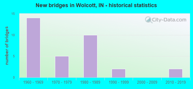
- New bridges - historical statistics
- 141960-1969
- 51970-1979
- 101980-1989
- 21990-1999
- 22010-2019

- Reconstructed bridges - Historical Statistics
- 21990-1999
- 02000-2009
- 52010-2019


- Bridge Condition - Deck
- 3.6%Excellent
- 42.9%Good
- 35.7%Satisfactory
- 14.3%Fair
- 3.6%Poor

- Bridge Condition - Superstructure
- 3.6%Excellent
- 39.3%Good
- 42.9%Satisfactory
- 10.7%Fair
- 3.6%Poor

- Bridge Condition - Substructure
- 3.6%Excellent
- 3.6%Very good
- 53.6%Good
- 32.1%Satisfactory
- 7.1%Fair

- Bridge Condition - Channel
- 3.7%Excellent
- 25.9%Very good
- 55.6%Good
- 14.8%Satisfactory
Find on map >> Show street view
Structure Number: 2943, Location: 04.13 N I-65 S JCT (Lat: 40.728289, Lng: -87.041139), Route carried "on" structure: US 231, Year Built: 1994, Status: Open, Structure Length: 2.55m (8.37ft), Average Daily Traffic: 1,833 (year 2004), Truck Traffic: 10%, Average Future Daily Traffic: 3,043 (year 2030), Design Load: HS 20, Features Intersected: HOAGLAND DITCH
Minimum Vertical Clearance: 30+ m (98+ ft), Kilometerpoint: 18.524, Lanes on structure: 2, Owner: State Highway Agency, Approaching Roadway Width: 10.1m (33.1ft), Material/Design: Concrete continuous, Design/Construction: Slab, Number Of Spans In Main Unit: 3, Length of Maximum Span: 9.8m (32.2ft), Curb-To-Curb Width: 10.2m (33.5ft), Out-to-Out Width: 11.1m (36.4ft)
Condition: Deck: Good, Superstructure: Good, Substructure: Good, Channel: Good, Operating Rating: 35.0 metric tons, Method Used To Determine Operating Rating: Load and Resistance Factor Rating (LRFR) rating reported by rating factor(RF) method using HL-93 loadings, Inventory Rating: 27.2 metric tons, Method Used To Determine Inventory Rating: Load and Resistance Factor Rating (LRFR) rating reported by rating factor(RF) method using HL-93 loadings, Structural Evaluation: Equal to present minimum criteria, Deck Geometry: Somewhat better than minimum adequacy, Waterway Adequacy: Superior to present desirable criteria, Approach Roadway Alignment: Equal to present desirable criteria, Designated Inspection Frequency: Every 24 months, Inspection Date: April 2020, Deck Structure Type: Concrete Cast-file-Place, Wearing Surface/Protective System: Wearing Surface: Monolithic Concrete, Deck Protection: Epoxy Coated Reinforcing
Find on map >> Show street view
Structure Number: 2944, Location: 04.29 N I-65 S JCT (Lat: 40.730650, Lng: -87.041161), Route carried "on" structure: US 231, Year Built: 1994, Status: Open, Structure Length: 2.87m (9.42ft), Average Daily Traffic: 1,450 (year 2010), Truck Traffic: 7%, Average Future Daily Traffic: 2,407 (year 2030), Design Load: HS 20, Features Intersected: HOLLINGSWORTH DITCH
Minimum Vertical Clearance: 30+ m (98+ ft), Kilometerpoint: 18.781, Lanes on structure: 2, Owner: State Highway Agency, Approaching Roadway Width: 10.1m (33.1ft), Skew: 3 degrees, Material/Design: Concrete continuous, Design/Construction: Slab, Number Of Spans In Main Unit: 3, Length of Maximum Span: 11.3m (37.1ft), Curb-To-Curb Width: 10.2m (33.5ft), Out-to-Out Width: 11.1m (36.4ft)
Condition: Deck: Good, Superstructure: Good, Substructure: Good, Channel: Good, Operating Rating: 37.9 metric tons, Method Used To Determine Operating Rating: Load and Resistance Factor Rating (LRFR) rating reported by rating factor(RF) method using HL-93 loadings, Inventory Rating: 29.2 metric tons, Method Used To Determine Inventory Rating: Load and Resistance Factor Rating (LRFR) rating reported by rating factor(RF) method using HL-93 loadings, Structural Evaluation: Better than present minimum criteria, Deck Geometry: Somewhat better than minimum adequacy, Waterway Adequacy: Equal to present desirable criteria, Approach Roadway Alignment: Equal to present desirable criteria, Designated Inspection Frequency: Every 24 months, Inspection Date: April 2020, Deck Structure Type: Concrete Cast-file-Place, Wearing Surface/Protective System: Wearing Surface: Monolithic Concrete, Deck Protection: Epoxy Coated Reinforcing
Find on map >> Show street view
Structure Number: 3791, Location: 02.93 N US 231 (Lat: 40.703989, Lng: -87.067589), Route carried "on" structure: Interstate 65, Year Built: 1968, Year Reconstructed: 1998, Status: Open, Structure Length: 2.87m (9.42ft), Average Daily Traffic: 14,828 (year 2004), Truck Traffic: 10%, Average Future Daily Traffic: 26,853 (year 2034), Design Load: HS 20+Mod, Features Intersected: HOAGLAND DITCH
Minimum Vertical Clearance: 30+ m (98+ ft), Kilometerpoint: 315.254, Lanes on structure: 2, Base Highway Network: Yes (, Subroute: 1), Owner: State Highway Agency, Approaching Roadway Width: 11.6m (38.1ft), Material/Design: Concrete continuous, Design/Construction: Slab, Number Of Spans In Main Unit: 3, Length of Maximum Span: 10.5m (34.4ft), Curb-To-Curb Width: 12.0m (39.4ft), Out-to-Out Width: 13.0m (42.7ft)
Condition: Deck: Satisfactory, Superstructure: Satisfactory, Substructure: Good, Channel: Good, Operating Rating: 39.9 metric tons, Method Used To Determine Operating Rating: Load and Resistance Factor Rating (LRFR) rating reported by rating factor(RF) method using HL-93 loadings, Inventory Rating: 30.8 metric tons, Method Used To Determine Inventory Rating: Load and Resistance Factor Rating (LRFR) rating reported by rating factor(RF) method using HL-93 loadings, Structural Evaluation: Equal to present minimum criteria, Deck Geometry: Equal to present minimum criteria, Waterway Adequacy: Superior to present desirable criteria, Approach Roadway Alignment: Equal to present desirable criteria, Designated Inspection Frequency: Every 24 months, Inspection Date: August 2021, Deck Structure Type: Concrete Cast-file-Place, Wearing Surface/Protective System: Wearing Surface: Latex Concrete
Find on map >> Show street view
Structure Number: 3792, Location: 02.93 N US 231 (Lat: 40.703861, Lng: -87.067869), Route carried "on" structure: Interstate 65, Year Built: 1968, Year Reconstructed: 1998, Status: Open, Structure Length: 2.87m (9.42ft), Average Daily Traffic: 14,828 (year 2004), Truck Traffic: 10%, Average Future Daily Traffic: 26,853 (year 2034), Design Load: HS 20+Mod, Features Intersected: HOAGLAND DITCH
Minimum Vertical Clearance: 30+ m (98+ ft), Kilometerpoint: 315.254, Lanes on structure: 2, Base Highway Network: Yes (, Subroute: 1), Owner: State Highway Agency, Approaching Roadway Width: 11.6m (38.1ft), Material/Design: Concrete continuous, Design/Construction: Slab, Number Of Spans In Main Unit: 3, Length of Maximum Span: 10.5m (34.4ft), Curb-To-Curb Width: 12.0m (39.4ft), Out-to-Out Width: 13.0m (42.7ft)
Condition: Deck: Satisfactory, Superstructure: Satisfactory, Substructure: Good, Channel: Very good, Operating Rating: 39.9 metric tons, Method Used To Determine Operating Rating: Load and Resistance Factor Rating (LRFR) rating reported by rating factor(RF) method using HL-93 loadings, Inventory Rating: 30.8 metric tons, Method Used To Determine Inventory Rating: Load and Resistance Factor Rating (LRFR) rating reported by rating factor(RF) method using HL-93 loadings, Structural Evaluation: Equal to present minimum criteria, Deck Geometry: Equal to present minimum criteria, Waterway Adequacy: Equal to present desirable criteria, Approach Roadway Alignment: Equal to present desirable criteria, Designated Inspection Frequency: Every 24 months, Inspection Date: August 2021, Deck Structure Type: Concrete Cast-file-Place, Wearing Surface/Protective System: Wearing Surface: Latex Concrete
Find on map >> Show street view
Structure Number: 3793, Location: 03.15 N US 231 (Lat: 40.706889, Lng: -87.070050), Route carried "on" structure: County highway , Year Built: 1968, Year Reconstructed: 2016, Status: Open, Structure Length: 8.33m (27.33ft), Average Daily Traffic: 200 (year 2017), Truck Traffic: 15%, Average Future Daily Traffic: 220 (year 2037), Design Load: HS 20, Features Intersected: I-65 SB/NB, Facility Carried by Structure: CR 300 S/GOSS ROAD
Minimum Vertical Clearance: 30+ m (98+ ft), Kilometerpoint: 0.000, Lanes on structure: 2, Lanes under structure: 4, Owner: State Highway Agency, Approaching Roadway Width: 6.1m (20.0ft), Skew: 3 degrees, Material/Design: Prestressed concrete continuous, Design/Construction: Stringer/Multi-beam, Number Of Spans In Main Unit: 4, Length of Maximum Span: 30.6m (100.4ft), Curb-To-Curb Width: 8.7m (28.5ft), Out-to-Out Width: 9.6m (31.5ft)
Condition: Deck: Satisfactory, Superstructure: Satisfactory, Substructure: Satisfactory, Operating Rating: 36.9 metric tons, Method Used To Determine Operating Rating: Load and Resistance Factor Rating (LRFR) rating reported by rating factor(RF) method using HL-93 loadings, Inventory Rating: 28.5 metric tons, Method Used To Determine Inventory Rating: Load and Resistance Factor Rating (LRFR) rating reported by rating factor(RF) method using HL-93 loadings, Structural Evaluation: Equal to present minimum criteria, Deck Geometry: Equal to present minimum criteria, Underclear: Equal to present minimum criteria, Approach Roadway Alignment: Equal to present desirable criteria, Designated Inspection Frequency: Every 24 months, Inspection Date: August 2021, Deck Structure Type: Concrete Cast-file-Place, Wearing Surface/Protective System: Wearing Surface: Latex Concrete
Find on map >> Show street view
Structure Number: 3794, Location: 03.93 S US 24 (Lat: 40.717881, Lng: -87.078781), Route carried "on" structure: County highway , Year Built: 1968, Status: Open, Structure Length: 8.15m (26.74ft), Average Daily Traffic: 163 (year 2004), Truck Traffic: 10%, Average Future Daily Traffic: 270 (year 2034), Design Load: HS 20, Features Intersected: I-65 NB/SB, Facility Carried by Structure: HANNA RD/CR 1100 W
Minimum Vertical Clearance: 30+ m (98+ ft), Kilometerpoint: 0.000, Lanes on structure: 2, Lanes under structure: 4, Owner: State Highway Agency, Approaching Roadway Width: 6.1m (20.0ft), Skew: 3 degrees, Material/Design: Steel continuous, Design/Construction: Stringer/Multi-beam, Number Of Spans In Main Unit: 2, Length of Maximum Span: 39.8m (130.6ft), Curb or Sidewalk Widths: Left: 0.1m (0.3ft), Right: 0.1m (0.3ft), Curb-To-Curb Width: 8.7m (28.5ft), Out-to-Out Width: 9.6m (31.5ft)
Condition: Deck: Good, Superstructure: Satisfactory, Substructure: Good, Operating Rating: 64.8 metric tons, Method Used To Determine Operating Rating: Load Factor (LF), Inventory Rating: 38.8 metric tons, Method Used To Determine Inventory Rating: Load Factor (LF), Structural Evaluation: Equal to present minimum criteria, Deck Geometry: Equal to present minimum criteria, Underclear: Equal to present minimum criteria, Approach Roadway Alignment: Equal to present desirable criteria, Designated Inspection Frequency: Every 24 months, Inspection Date: August 2021, Deck Structure Type: Concrete Cast-file-Place, Wearing Surface/Protective System: Wearing Surface: Latex Concrete
Find on map >> Show street view
Structure Number: 3795, Location: 03.63 S US 24 (Lat: 40.721819, Lng: -87.081739), Route carried "on" structure: Interstate 65, Year Built: 1968, Year Reconstructed: 2016, Status: Open, Structure Length: 2.62m (8.60ft), Average Daily Traffic: 14,828 (year 2004), Truck Traffic: 10%, Average Future Daily Traffic: 26,853 (year 2034), Design Load: HS 20+Mod, Features Intersected: HOLLINGSWORTH DITCH
Minimum Vertical Clearance: 30+ m (98+ ft), Kilometerpoint: 317.540, Lanes on structure: 2, Base Highway Network: Yes (, Subroute: 1), Owner: State Highway Agency, Approaching Roadway Width: 12.2m (40.0ft), Material/Design: Concrete continuous, Design/Construction: Slab, Number Of Spans In Main Unit: 3, Length of Maximum Span: 10.7m (35.1ft), Curb-To-Curb Width: 12.1m (39.7ft), Out-to-Out Width: 13.0m (42.7ft)
Condition: Deck: Satisfactory, Superstructure: Satisfactory, Substructure: Good, Channel: Very good, Operating Rating: 42.1 metric tons, Method Used To Determine Operating Rating: Load and Resistance Factor Rating (LRFR) rating reported by rating factor(RF) method using HL-93 loadings, Inventory Rating: 32.4 metric tons, Method Used To Determine Inventory Rating: Load and Resistance Factor Rating (LRFR) rating reported by rating factor(RF) method using HL-93 loadings, Structural Evaluation: Equal to present minimum criteria, Deck Geometry: Equal to present minimum criteria, Waterway Adequacy: Superior to present desirable criteria, Approach Roadway Alignment: Equal to present desirable criteria, Designated Inspection Frequency: Every 24 months, Inspection Date: August 2021, Deck Structure Type: Concrete Cast-file-Place, Wearing Surface/Protective System: Wearing Surface: Latex Concrete
Find on map >> Show street view
Structure Number: 3796, Location: 03.63 S US 24 (Lat: 40.721711, Lng: -87.082019), Route carried "on" structure: Interstate 65, Year Built: 1968, Year Reconstructed: 2016, Status: Open, Structure Length: 2.62m (8.60ft), Average Daily Traffic: 14,828 (year 2004), Truck Traffic: 10%, Average Future Daily Traffic: 26,853 (year 2034), Design Load: HS 20+Mod, Features Intersected: HOLLINGSWORTH DITCH
Minimum Vertical Clearance: 30+ m (98+ ft), Kilometerpoint: 317.540, Lanes on structure: 2, Base Highway Network: Yes (, Subroute: 1), Owner: State Highway Agency, Approaching Roadway Width: 12.2m (40.0ft), Material/Design: Concrete continuous, Design/Construction: Slab, Number Of Spans In Main Unit: 3, Length of Maximum Span: 10.7m (35.1ft), Curb-To-Curb Width: 12.1m (39.7ft), Out-to-Out Width: 13.0m (42.7ft)
Condition: Deck: Fair, Superstructure: Fair, Substructure: Good, Channel: Very good, Operating Rating: 42.1 metric tons, Method Used To Determine Operating Rating: Load and Resistance Factor Rating (LRFR) rating reported by rating factor(RF) method using HL-93 loadings, Inventory Rating: 32.4 metric tons, Method Used To Determine Inventory Rating: Load and Resistance Factor Rating (LRFR) rating reported by rating factor(RF) method using HL-93 loadings, Structural Evaluation: Somewhat better than minimum adequacy, Deck Geometry: Equal to present minimum criteria, Waterway Adequacy: Better than present minimum criteria, Approach Roadway Alignment: Equal to present desirable criteria, Designated Inspection Frequency: Every 24 months, Inspection Date: August 2021, Deck Structure Type: Concrete Cast-file-Place, Wearing Surface/Protective System: Wearing Surface: Latex Concrete
Find on map >> Show street view
Structure Number: 3797, Location: 02.73 S US 24 (Lat: 40.732989, Lng: -87.090581), Route carried "on" structure: Interstate 65, Year Built: 1968, Year Reconstructed: 2016, Status: Open, Structure Length: 1.92m (6.30ft), Average Daily Traffic: 14,828 (year 2004), Truck Traffic: 10%, Average Future Daily Traffic: 26,853 (year 2034), Design Load: HS 20+Mod, Features Intersected: MASON EASTBURN DITCH
Minimum Vertical Clearance: 30+ m (98+ ft), Kilometerpoint: 318.988, Lanes on structure: 2, Base Highway Network: Yes (, Subroute: 1), Owner: State Highway Agency, Approaching Roadway Width: 12.2m (40.0ft), Skew: 3 degrees, Material/Design: Concrete continuous, Design/Construction: Slab, Number Of Spans In Main Unit: 3, Length of Maximum Span: 7.6m (24.9ft), Curb-To-Curb Width: 12.1m (39.7ft), Out-to-Out Width: 13.0m (42.7ft)
Condition: Deck: Satisfactory, Superstructure: Satisfactory, Substructure: Good, Channel: Very good, Operating Rating: 53.8 metric tons, Method Used To Determine Operating Rating: Load and Resistance Factor Rating (LRFR) rating reported by rating factor(RF) method using HL-93 loadings, Inventory Rating: 41.5 metric tons, Method Used To Determine Inventory Rating: Load and Resistance Factor Rating (LRFR) rating reported by rating factor(RF) method using HL-93 loadings, Structural Evaluation: Equal to present minimum criteria, Deck Geometry: Equal to present minimum criteria, Waterway Adequacy: Superior to present desirable criteria, Approach Roadway Alignment: Equal to present desirable criteria, Designated Inspection Frequency: Every 24 months, Inspection Date: August 2021, Deck Structure Type: Concrete Cast-file-Place, Wearing Surface/Protective System: Wearing Surface: Latex Concrete
Find on map >> Show street view
Structure Number: 3798, Location: 02.73 S US 24 (Lat: 40.732969, Lng: -87.090939), Route carried "on" structure: Interstate 65, Year Built: 1968, Year Reconstructed: 2016, Status: Open, Structure Length: 1.92m (6.30ft), Average Daily Traffic: 14,828 (year 2004), Truck Traffic: 10%, Average Future Daily Traffic: 26,853 (year 2034), Design Load: HS 20+Mod, Features Intersected: MASON EASTBURN DITCH
Minimum Vertical Clearance: 30+ m (98+ ft), Kilometerpoint: 318.988, Lanes on structure: 2, Base Highway Network: Yes (, Subroute: 1), Owner: State Highway Agency, Approaching Roadway Width: 12.2m (40.0ft), Skew: 3 degrees, Material/Design: Concrete continuous, Design/Construction: Slab, Number Of Spans In Main Unit: 3, Length of Maximum Span: 7.6m (24.9ft), Curb-To-Curb Width: 12.1m (39.7ft), Out-to-Out Width: 13.0m (42.7ft)
Condition: Deck: Satisfactory, Superstructure: Satisfactory, Substructure: Good, Channel: Very good, Operating Rating: 53.8 metric tons, Method Used To Determine Operating Rating: Load and Resistance Factor Rating (LRFR) rating reported by rating factor(RF) method using HL-93 loadings, Inventory Rating: 41.5 metric tons, Method Used To Determine Inventory Rating: Load and Resistance Factor Rating (LRFR) rating reported by rating factor(RF) method using HL-93 loadings, Structural Evaluation: Equal to present minimum criteria, Deck Geometry: Equal to present minimum criteria, Waterway Adequacy: Superior to present desirable criteria, Approach Roadway Alignment: Equal to present desirable criteria, Designated Inspection Frequency: Every 24 months, Inspection Date: August 2021, Deck Structure Type: Concrete Cast-file-Place, Wearing Surface/Protective System: Wearing Surface: Latex Concrete
Find on map >> Show street view
Structure Number: 60632, Location: 02.80 N I-65 (Lat: 40.708600, Lng: -87.041019), Route carried "on" structure: US 231, Year Built: 2012, Status: Open, Structure Length: 1.71m (5.61ft), Average Daily Traffic: 1,930 (year 2012), Truck Traffic: 21%, Average Future Daily Traffic: 2,440 (year 2030), Design Load: HL 93, Features Intersected: UNNAMED TRIBUTARY
Minimum Vertical Clearance: 30+ m (98+ ft), Kilometerpoint: 370.551, Lanes on structure: 2, Owner: State Highway Agency, Approaching Roadway Width: 12.2m (40.0ft), Skew: 4 degrees, Material/Design: Concrete, Design/Construction: Culvert, Number Of Spans In Main Unit: 1, Length of Maximum Span: 5.5m (18.0ft), Curb-To-Curb Width: 12.2m (40.0ft), Out-to-Out Width: 29.0m (95.1ft)
Condition: Channel: Very good, Culverts: Very good, Operating Rating: 59.0 metric tons, Method Used To Determine Operating Rating: Load and Resistance Factor (LRFR), Inventory Rating: 45.4 metric tons, Method Used To Determine Inventory Rating: Load and Resistance Factor (LRFR), Structural Evaluation: Equal to present desirable criteria, Deck Geometry: Better than present minimum criteria, Waterway Adequacy: Equal to present desirable criteria, Approach Roadway Alignment: Equal to present desirable criteria, Designated Inspection Frequency: Every 24 months, Inspection Date: July 2021
Find on map >> Show street view
Structure Number: 9100102, Location: 00.17 W CR 1000 W (Lat: 40.823211, Lng: -87.064781), Route carried "on" structure: County highway 74, Year Built: 1988, Status: Open, Structure Length: 2.26m (7.41ft), Average Daily Traffic: 120 (year 2018), Truck Traffic: 5%, Average Future Daily Traffic: 125 (year 2038), Design Load: HS 20, Features Intersected: KEEFE DITCH, Facility Carried by Structure: CR 500N
Minimum Vertical Clearance: 30+ m (98+ ft), Kilometerpoint: 0.000, Lanes on structure: 2, Owner: County Highway Agency, Approaching Roadway Width: 4.9m (16.1ft), Skew: 4 degrees, Material/Design: Concrete continuous, Design/Construction: Slab, Number Of Spans In Main Unit: 3, Length of Maximum Span: 8.2m (26.9ft), Curb-To-Curb Width: 8.5m (27.9ft), Out-to-Out Width: 8.5m (27.9ft)
Condition: Deck: Good, Superstructure: Good, Substructure: Good, Channel: Good, Operating Rating: 54.9 metric tons, Method Used To Determine Operating Rating: Field evaluation and documented engineering judgment, Inventory Rating: 32.9 metric tons, Method Used To Determine Inventory Rating: Field evaluation and documented engineering judgment, Structural Evaluation: Better than present minimum criteria, Deck Geometry: Equal to present minimum criteria, Waterway Adequacy: Equal to present desirable criteria, Approach Roadway Alignment: Equal to present desirable criteria, Designated Inspection Frequency: Every 24 months, Inspection Date: October 2020, Deck Structure Type: Concrete Cast-file-Place, Wearing Surface/Protective System: Wearing Surface: Monolithic Concrete
Find on map >> Show street view
Structure Number: 9100109, Location: 00.13 S CR 500 N (Lat: 40.821350, Lng: -87.061611), Route carried "on" structure: County highway 9, Year Built: 1980, Status: Open, Structure Length: 1.46m (4.79ft), Average Daily Traffic: 120 (year 2018), Truck Traffic: 5%, Average Future Daily Traffic: 125 (year 2038), Design Load: HS 20, Features Intersected: FRANK MAY DITCH, Facility Carried by Structure: CR 1000W
Minimum Vertical Clearance: 30+ m (98+ ft), Kilometerpoint: 0.000, Lanes on structure: 2, Owner: County Highway Agency, Approaching Roadway Width: 5.5m (18.0ft), Material/Design: Prestressed concrete, Design/Construction: Box Beam or Girders - Multiple, Number Of Spans In Main Unit: 1, Length of Maximum Span: 13.3m (43.6ft), Curb-To-Curb Width: 7.3m (24.0ft), Out-to-Out Width: 7.3m (24.0ft)
Condition: Deck: Good, Superstructure: Good, Substructure: Very good, Channel: Good, Operating Rating: 57.6 metric tons, Method Used To Determine Operating Rating: Load Factor (LF), Inventory Rating: 34.5 metric tons, Method Used To Determine Inventory Rating: Load Factor (LF), Structural Evaluation: Better than present minimum criteria, Deck Geometry: Somewhat better than minimum adequacy, Waterway Adequacy: Equal to present minimum criteria, Approach Roadway Alignment: Equal to present desirable criteria, Designated Inspection Frequency: Every 24 months, Inspection Date: October 2020, Deck Structure Type: Concrete Precast Panels, Wearing Surface/Protective System: Wearing Surface: Bituminous, Membrane: Preformed Fabric
Find on map >> Show street view
Structure Number: 9100113, Location: 00.23 E CR 600 W (Lat: 40.735789, Lng: -86.981731), Route carried "on" structure: County highway 40, Year Built: 1978, Status: Open, Structure Length: 1.71m (5.61ft), Average Daily Traffic: 120 (year 2018), Truck Traffic: 5%, Average Future Daily Traffic: 150 (year 2038), Design Load: HS 20, Features Intersected: HONEY CREEK, Facility Carried by Structure: CR 100S
Minimum Vertical Clearance: 30+ m (98+ ft), Kilometerpoint: 0.000, Lanes on structure: 2, Owner: County Highway Agency, Approaching Roadway Width: 4.9m (16.1ft), Skew: 2 degrees, Material/Design: Prestressed concrete, Design/Construction: Box Beam or Girders - Multiple, Number Of Spans In Main Unit: 3, Length of Maximum Span: 6.1m (20.0ft), Curb or Sidewalk Widths: Left: 0.3m (1.0ft), Right: 0.3m (1.0ft), Curb-To-Curb Width: 6.8m (22.3ft), Out-to-Out Width: 7.4m (24.3ft)
Condition: Deck: Good, Superstructure: Good, Substructure: Good, Channel: Very good, Operating Rating: 61.0 metric tons, Method Used To Determine Operating Rating: Load Factor (LF), Inventory Rating: 36.5 metric tons, Method Used To Determine Inventory Rating: Load Factor (LF), Structural Evaluation: Better than present minimum criteria, Deck Geometry: Meets minimum limits, Waterway Adequacy: Equal to present minimum criteria, Approach Roadway Alignment: Equal to present desirable criteria, Designated Inspection Frequency: Every 24 months, Inspection Date: November 2020, Deck Structure Type: Concrete Precast Panels, Wearing Surface/Protective System: Wearing Surface: Bituminous, Membrane: Preformed Fabric
Find on map >> Show street view
Structure Number: 9100114, Location: 00.37 E CR 800 W (Lat: 40.735919, Lng: -87.017511), Route carried "on" structure: County highway 40, Year Built: 1980, Status: Open, Structure Length: 2.19m (7.19ft), Average Daily Traffic: 100 (year 2018), Truck Traffic: 5%, Average Future Daily Traffic: 150 (year 2038), Design Load: HS 20, Features Intersected: HOAGLAND DITCH, Facility Carried by Structure: CR 100S
Minimum Vertical Clearance: 30+ m (98+ ft), Kilometerpoint: 0.000, Lanes on structure: 2, Owner: County Highway Agency, Approaching Roadway Width: 4.9m (16.1ft), Material/Design: Prestressed concrete, Design/Construction: Box Beam or Girders - Multiple, Number Of Spans In Main Unit: 3, Length of Maximum Span: 7.3m (24.0ft), Curb or Sidewalk Widths: Left: 0.3m (1.0ft), Right: 0.3m (1.0ft), Curb-To-Curb Width: 6.8m (22.3ft), Out-to-Out Width: 7.4m (24.3ft)
Condition: Deck: Satisfactory, Superstructure: Satisfactory, Substructure: Satisfactory, Channel: Satisfactory, Operating Rating: 69.6 metric tons, Method Used To Determine Operating Rating: Load Factor (LF), Inventory Rating: 41.7 metric tons, Method Used To Determine Inventory Rating: Load Factor (LF), Structural Evaluation: Equal to present minimum criteria, Deck Geometry: Somewhat better than minimum adequacy, Waterway Adequacy: Better than present minimum criteria, Approach Roadway Alignment: Equal to present desirable criteria, Designated Inspection Frequency: Every 24 months, Inspection Date: October 2020, Deck Structure Type: Concrete Precast Panels, Wearing Surface/Protective System: Wearing Surface: Monolithic Concrete
Find on map >> Show street view
Structure Number: 9100118, Location: 00.42 S CR 200 N (Lat: 40.773400, Lng: -87.024561), Route carried "on" structure: County highway 15, Year Built: 1980, Status: Open, Structure Length: 1.46m (4.79ft), Average Daily Traffic: 100 (year 2018), Truck Traffic: 5%, Average Future Daily Traffic: 125 (year 2038), Design Load: HS 20, Features Intersected: SWYGMAN DITCH, Facility Carried by Structure: CR 800W
Minimum Vertical Clearance: 30+ m (98+ ft), Kilometerpoint: 0.000, Lanes on structure: 2, Owner: County Highway Agency, Approaching Roadway Width: 4.9m (16.1ft), Material/Design: Prestressed concrete, Design/Construction: Box Beam or Girders - Multiple, Number Of Spans In Main Unit: 1, Length of Maximum Span: 13.4m (44.0ft), Curb-To-Curb Width: 7.3m (24.0ft), Out-to-Out Width: 7.4m (24.3ft)
Condition: Deck: Good, Superstructure: Good, Substructure: Satisfactory, Channel: Satisfactory, Operating Rating: 55.9 metric tons, Method Used To Determine Operating Rating: Load Factor (LF), Inventory Rating: 33.5 metric tons, Method Used To Determine Inventory Rating: Load Factor (LF), Structural Evaluation: Equal to present minimum criteria, Deck Geometry: Equal to present minimum criteria, Waterway Adequacy: Better than present minimum criteria, Approach Roadway Alignment: Equal to present desirable criteria, Designated Inspection Frequency: Every 24 months, Inspection Date: October 2020, Deck Structure Type: Concrete Precast Panels, Wearing Surface/Protective System: Wearing Surface: Monolithic Concrete
Find on map >> Show street view
Structure Number: 9100119, Location: 00.37 S CR 200 N (Lat: 40.774431, Lng: -87.005431), Route carried "on" structure: County highway 19, Year Built: 1980, Status: Open, Structure Length: 2.01m (6.59ft), Average Daily Traffic: 120 (year 2018), Truck Traffic: 5%, Average Future Daily Traffic: 150 (year 2038), Design Load: HS 20, Features Intersected: SWYGMAN DITCH, Facility Carried by Structure: CR 700W
Minimum Vertical Clearance: 30+ m (98+ ft), Kilometerpoint: 0.000, Lanes on structure: 2, Owner: County Highway Agency, Approaching Roadway Width: 4.9m (16.1ft), Skew: 2 degrees, Material/Design: Prestressed concrete, Design/Construction: Box Beam or Girders - Multiple, Number Of Spans In Main Unit: 3, Length of Maximum Span: 6.7m (22.0ft), Curb or Sidewalk Widths: Left: 0.3m (1.0ft), Right: 0.3m (1.0ft), Curb-To-Curb Width: 6.7m (22.0ft), Out-to-Out Width: 7.3m (24.0ft)
Condition: Deck: Good, Superstructure: Good, Substructure: Good, Channel: Good, Operating Rating: 72.2 metric tons, Method Used To Determine Operating Rating: Load Factor (LF), Inventory Rating: 43.2 metric tons, Method Used To Determine Inventory Rating: Load Factor (LF), Structural Evaluation: Better than present minimum criteria, Deck Geometry: Meets minimum limits, Waterway Adequacy: Better than present minimum criteria, Approach Roadway Alignment: Equal to present desirable criteria, Designated Inspection Frequency: Every 24 months, Inspection Date: October 2020, Deck Structure Type: Concrete Precast Panels, Wearing Surface/Protective System: Wearing Surface: Monolithic Concrete
Find on map >> Show street view
Structure Number: 910012, Location: 00.12 S US 24 (Lat: 40.748739, Lng: -87.005389), Route carried "on" structure: County highway 19, Year Built: 1977, Status: Open, Structure Length: 2.13m (6.99ft), Average Daily Traffic: 175 (year 2018), Truck Traffic: 5%, Average Future Daily Traffic: 225 (year 2038), Design Load: HS 20, Features Intersected: HOAGLAND DITCH, Facility Carried by Structure: CR 700W
Minimum Vertical Clearance: 30+ m (98+ ft), Kilometerpoint: 0.000, Lanes on structure: 2, Owner: County Highway Agency, Approaching Roadway Width: 5.8m (19.0ft), Material/Design: Prestressed concrete, Design/Construction: Box Beam or Girders - Multiple, Number Of Spans In Main Unit: 3, Length of Maximum Span: 7.9m (25.9ft), Curb or Sidewalk Widths: Left: 0.3m (1.0ft), Right: 0.3m (1.0ft), Curb-To-Curb Width: 6.7m (22.0ft), Out-to-Out Width: 7.3m (24.0ft)
Condition: Deck: Fair, Superstructure: Fair, Substructure: Fair, Channel: Good, Operating Rating: 57.4 metric tons, Method Used To Determine Operating Rating: Load Factor (LF), Inventory Rating: 34.4 metric tons, Method Used To Determine Inventory Rating: Load Factor (LF), Structural Evaluation: Somewhat better than minimum adequacy, Deck Geometry: Meets minimum limits, Waterway Adequacy: Better than present minimum criteria, Approach Roadway Alignment: Equal to present desirable criteria, Length Of Structure Improvement: 2.77m (9.09ft), Designated Inspection Frequency: Every 24 months, Inspection Date: October 2020, Bridge Improvement Cost: $443,000, Roadway Improvement Cost: $49,000, Total Project Cost: $492,000 ( Estimate for 2018), Deck Structure Type: Concrete Precast Panels, Wearing Surface/Protective System: Wearing Surface: Bituminous
Find on map >> Show street view
Structure Number: 9100121, Location: 00.04 S US 24 (Lat: 40.749839, Lng: -86.986339), Route carried "on" structure: County highway 23, Year Built: 1966, Status: Open, Structure Length: 3.11m (10.20ft), Average Daily Traffic: 175 (year 2018), Truck Traffic: 5%, Average Future Daily Traffic: 225 (year 2038), Design Load: HS 20, Features Intersected: HOAGLAND DITCH, Facility Carried by Structure: CR 600W
Minimum Vertical Clearance: 30+ m (98+ ft), Kilometerpoint: 0.000, Lanes on structure: 2, Owner: County Highway Agency, Approaching Roadway Width: 6.1m (20.0ft), Material/Design: Prestressed concrete continuous, Design/Construction: Box Beam or Girders - Single/Spread, Number Of Spans In Main Unit: 3, Length of Maximum Span: 10.4m (34.1ft), Curb or Sidewalk Widths: Left: 0.5m (1.6ft), Right: 0.5m (1.6ft), Curb-To-Curb Width: 8.1m (26.6ft), Out-to-Out Width: 9.0m (29.5ft)
Condition: Deck: Fair, Superstructure: Satisfactory, Substructure: Satisfactory, Channel: Good, Operating Rating: 54.5 metric tons, Method Used To Determine Operating Rating: Load Factor (LF), Inventory Rating: 32.7 metric tons, Method Used To Determine Inventory Rating: Load Factor (LF), Structural Evaluation: Equal to present minimum criteria, Deck Geometry: Somewhat better than minimum adequacy, Waterway Adequacy: Equal to present desirable criteria, Approach Roadway Alignment: Equal to present desirable criteria, Length Of Structure Improvement: 3.11m (10.20ft), Designated Inspection Frequency: Every 24 months, Inspection Date: October 2020, Bridge Improvement Cost: $500,000, Roadway Improvement Cost: $100,000, Total Project Cost: $600,000 ( Estimate for 2016), Deck Structure Type: Concrete Cast-file-Place, Wearing Surface/Protective System: Wearing Surface: Monolithic Concrete
Find on map >> Show street view
Structure Number: 9100122, Location: 00.21 S CR 200 N (Lat: 40.776631, Lng: -86.986561), Route carried "on" structure: County highway 23, Year Built: 1973, Status: Open, Structure Length: 1.46m (4.79ft), Average Daily Traffic: 120 (year 2018), Truck Traffic: 5%, Average Future Daily Traffic: 150 (year 2038), Design Load: HS 20, Features Intersected: SWYGMAN DITCH, Facility Carried by Structure: CR 600W
Minimum Vertical Clearance: 30+ m (98+ ft), Kilometerpoint: 0.000, Lanes on structure: 2, Owner: County Highway Agency, Approaching Roadway Width: 5.5m (18.0ft), Material/Design: Prestressed concrete, Design/Construction: Box Beam or Girders - Multiple, Number Of Spans In Main Unit: 1, Length of Maximum Span: 13.6m (44.6ft), Curb-To-Curb Width: 7.3m (24.0ft), Out-to-Out Width: 7.4m (24.3ft)
Condition: Deck: Fair, Superstructure: Fair, Substructure: Satisfactory, Channel: Satisfactory, Operating Rating: 59.3 metric tons, Method Used To Determine Operating Rating: Load Factor (LF), Inventory Rating: 35.5 metric tons, Method Used To Determine Inventory Rating: Load Factor (LF), Structural Evaluation: Somewhat better than minimum adequacy, Deck Geometry: Somewhat better than minimum adequacy, Waterway Adequacy: Somewhat better than minimum adequacy, Approach Roadway Alignment: Equal to present desirable criteria, Length Of Structure Improvement: 1.46m (4.79ft), Designated Inspection Frequency: Every 24 months, Inspection Date: October 2020, Bridge Improvement Cost: $200,000, Roadway Improvement Cost: $100,000, Total Project Cost: $300,000 ( Estimate for 2016), Deck Structure Type: Concrete Precast Panels, Wearing Surface/Protective System: Wearing Surface: Monolithic Concrete
Find on map >> Show street view
Structure Number: 9100131, Location: 00.10 N CR 200 S (Lat: 40.722719, Lng: -87.078869), Route carried "on" structure: County highway 5, Year Built: 1974, Status: Open, Structure Length: 1.83m (6.00ft), Average Daily Traffic: 225 (year 2018), Truck Traffic: 5%, Average Future Daily Traffic: 300 (year 2038), Design Load: HS 20, Features Intersected: HOLLINGSWORTH DITCH, Facility Carried by Structure: CR 1100W
Minimum Vertical Clearance: 30+ m (98+ ft), Kilometerpoint: 0.000, Lanes on structure: 2, Owner: County Highway Agency, Approaching Roadway Width: 5.8m (19.0ft), Skew: 1 degrees, Material/Design: Prestressed concrete, Design/Construction: Box Beam or Girders - Multiple, Number Of Spans In Main Unit: 3, Length of Maximum Span: 7.3m (24.0ft), Curb or Sidewalk Widths: Left: 0.3m (1.0ft), Right: 0.3m (1.0ft), Curb-To-Curb Width: 6.8m (22.3ft), Out-to-Out Width: 7.4m (24.3ft)
Condition: Deck: Poor, Superstructure: Poor, Substructure: Satisfactory, Channel: Good, Operating Rating: 55.7 metric tons, Method Used To Determine Operating Rating: Load Factor (LF), Inventory Rating: 33.4 metric tons, Method Used To Determine Inventory Rating: Load Factor (LF), Structural Evaluation: Meets minimum limits, Deck Geometry: Meets minimum limits, Waterway Adequacy: Equal to present minimum criteria, Approach Roadway Alignment: Equal to present desirable criteria, Length Of Structure Improvement: 1.83m (6.00ft), Designated Inspection Frequency: Every 12 months, Inspection Date: October 2021, Bridge Improvement Cost: $222,000, Roadway Improvement Cost: $25,000, Total Project Cost: $247,000 ( Estimate for 2018), Deck Structure Type: Concrete Precast Panels, Wearing Surface/Protective System: Wearing Surface: Bituminous
Find on map >> Show street view
Structure Number: 9100132, Location: 00.22 S CR 100 S (Lat: 40.733000, Lng: -87.060119), Route carried "on" structure: County highway 305, Year Built: 1989, Status: Open, Structure Length: 2.07m (6.79ft), Average Daily Traffic: 100 (year 2018), Truck Traffic: 5%, Average Future Daily Traffic: 120 (year 2038), Design Load: HS 20, Features Intersected: HOLLINGSWORTH DITCH, Facility Carried by Structure: CR 1000W
Minimum Vertical Clearance: 30+ m (98+ ft), Kilometerpoint: 0.000, Lanes on structure: 2, Owner: County Highway Agency, Approaching Roadway Width: 6.1m (20.0ft), Skew: 1 degrees, Material/Design: Prestressed concrete, Design/Construction: Box Beam or Girders - Multiple, Number Of Spans In Main Unit: 3, Length of Maximum Span: 8.5m (27.9ft), Curb-To-Curb Width: 8.5m (27.9ft), Out-to-Out Width: 8.5m (27.9ft)
Condition: Deck: Good, Superstructure: Good, Substructure: Good, Channel: Good, Operating Rating: 64.9 metric tons, Method Used To Determine Operating Rating: Load Factor (LF), Inventory Rating: 38.9 metric tons, Method Used To Determine Inventory Rating: Load Factor (LF), Structural Evaluation: Better than present minimum criteria, Deck Geometry: Better than present minimum criteria, Waterway Adequacy: Equal to present minimum criteria, Approach Roadway Alignment: Equal to present desirable criteria, Designated Inspection Frequency: Every 24 months, Inspection Date: November 2020, Deck Structure Type: Concrete Precast Panels, Wearing Surface/Protective System: Wearing Surface: Monolithic Concrete
Find on map >> Show street view
Structure Number: 9100133, Location: 00.28 S CR 200 S (Lat: 40.717089, Lng: -87.059919), Route carried "on" structure: County highway 305, Year Built: 1987, Status: Open, Structure Length: 2.01m (6.59ft), Average Daily Traffic: 100 (year 2018), Truck Traffic: 5%, Average Future Daily Traffic: 120 (year 2038), Design Load: HS 20, Features Intersected: HOAGLAND DITCH, Facility Carried by Structure: CR 1000W
Minimum Vertical Clearance: 30+ m (98+ ft), Kilometerpoint: 0.000, Lanes on structure: 2, Owner: County Highway Agency, Approaching Roadway Width: 5.5m (18.0ft), Skew: 2 degrees, Material/Design: Prestressed concrete, Design/Construction: Box Beam or Girders - Multiple, Number Of Spans In Main Unit: 3, Length of Maximum Span: 7.9m (25.9ft), Curb-To-Curb Width: 8.6m (28.2ft), Out-to-Out Width: 8.6m (28.2ft)
Condition: Deck: Good, Superstructure: Good, Substructure: Good, Channel: Good, Operating Rating: 64.6 metric tons, Method Used To Determine Operating Rating: Load Factor (LF), Inventory Rating: 38.7 metric tons, Method Used To Determine Inventory Rating: Load Factor (LF), Structural Evaluation: Better than present minimum criteria, Deck Geometry: Better than present minimum criteria, Waterway Adequacy: Better than present minimum criteria, Approach Roadway Alignment: Equal to present desirable criteria, Designated Inspection Frequency: Every 24 months, Inspection Date: November 2020, Deck Structure Type: Concrete Precast Panels, Wearing Surface/Protective System: Wearing Surface: Monolithic Concrete
Find on map >> Show street view
Structure Number: 9100136, Location: 00.32 E CR 1000 W (Lat: 40.721231, Lng: -87.053811), Route carried "on" structure: County highway 36, Year Built: 1977, Status: Open, Structure Length: 1.52m (4.99ft), Average Daily Traffic: 100 (year 2018), Truck Traffic: 5%, Average Future Daily Traffic: 125 (year 2038), Design Load: HS 20, Features Intersected: HOAGLAND DITCH, Facility Carried by Structure: CR 200S
Minimum Vertical Clearance: 30+ m (98+ ft), Kilometerpoint: 0.000, Lanes on structure: 2, Owner: County Highway Agency, Approaching Roadway Width: 5.5m (18.0ft), Material/Design: Prestressed concrete, Design/Construction: Box Beam or Girders - Multiple, Number Of Spans In Main Unit: 1, Length of Maximum Span: 14.3m (46.9ft), Curb-To-Curb Width: 7.0m (23.0ft), Out-to-Out Width: 7.4m (24.3ft)
Condition: Deck: Good, Superstructure: Good, Substructure: Fair, Channel: Good, Operating Rating: 56.4 metric tons, Method Used To Determine Operating Rating: Load Factor (LF), Inventory Rating: 33.8 metric tons, Method Used To Determine Inventory Rating: Load Factor (LF), Structural Evaluation: Somewhat better than minimum adequacy, Deck Geometry: Somewhat better than minimum adequacy, Waterway Adequacy: Better than present minimum criteria, Approach Roadway Alignment: Equal to present desirable criteria, Length Of Structure Improvement: 2.23m (7.32ft), Designated Inspection Frequency: Every 24 months, Inspection Date: October 2020, Bridge Improvement Cost: $422,000, Roadway Improvement Cost: $47,000, Total Project Cost: $469,000 ( Estimate for 2020), Deck Structure Type: Concrete Precast Panels, Wearing Surface/Protective System: Wearing Surface: Monolithic Concrete
Find on map >> Show street view
Structure Number: 9100137, Location: 00.75 E W COUNTY LINE RD (Lat: 40.721239, Lng: -87.082961), Route carried "on" structure: County highway 36, Year Built: 1984, Status: Open, Structure Length: 2.93m (9.61ft), Average Daily Traffic: 100 (year 2018), Truck Traffic: 5%, Average Future Daily Traffic: 120 (year 2038), Design Load: HS 20, Features Intersected: HOLLINGSWORTH DITCH, Facility Carried by Structure: CR 200S
Minimum Vertical Clearance: 30+ m (98+ ft), Kilometerpoint: 0.000, Lanes on structure: 2, Owner: County Highway Agency, Approaching Roadway Width: 5.8m (19.0ft), Skew: 5 degrees, Material/Design: Concrete continuous, Design/Construction: Slab, Number Of Spans In Main Unit: 3, Length of Maximum Span: 11.0m (36.1ft), Curb-To-Curb Width: 8.0m (26.2ft), Out-to-Out Width: 8.7m (28.5ft)
Condition: Deck: Satisfactory, Superstructure: Satisfactory, Substructure: Satisfactory, Channel: Good, Operating Rating: 55.1 metric tons, Method Used To Determine Operating Rating: Field evaluation and documented engineering judgment, Inventory Rating: 33.0 metric tons, Method Used To Determine Inventory Rating: Field evaluation and documented engineering judgment, Structural Evaluation: Equal to present minimum criteria, Deck Geometry: Equal to present minimum criteria, Waterway Adequacy: Better than present minimum criteria, Approach Roadway Alignment: Equal to present desirable criteria, Length Of Structure Improvement: 3.05m (10.01ft), Designated Inspection Frequency: Every 24 months, Inspection Date: November 2020, Bridge Improvement Cost: $300,000, Roadway Improvement Cost: $50,000, Total Project Cost: $350,000 ( Estimate for 2014), Deck Structure Type: Concrete Cast-file-Place, Wearing Surface/Protective System: Wearing Surface: Monolithic Concrete
Find on map >> Show street view
Structure Number: 9100154, Location: 00.17 S CR 100 S (Lat: 40.733419, Lng: -87.024450), Route carried "on" structure: County highway 13, Year Built: 1968, Status: Posted for load-capacity, Structure Length: 2.19m (7.19ft), Average Daily Traffic: 120 (year 2018), Truck Traffic: 5%, Average Future Daily Traffic: 150 (year 2038), Design Load: HS 20, Features Intersected: HOAGLAND DITCH, Facility Carried by Structure: CR 800W
Minimum Vertical Clearance: 30+ m (98+ ft), Kilometerpoint: 0.000, Lanes on structure: 2, Owner: County Highway Agency, Approaching Roadway Width: 5.5m (18.0ft), Skew: 1 degrees, Material/Design: Prestressed concrete, Design/Construction: Box Beam or Girders - Multiple, Number Of Spans In Main Unit: 3, Length of Maximum Span: 8.5m (27.9ft), Curb-To-Curb Width: 6.6m (21.7ft), Out-to-Out Width: 6.7m (22.0ft)
Condition: Deck: Satisfactory, Superstructure: Satisfactory, Substructure: Satisfactory, Channel: Satisfactory, Operating Rating: 66.5 metric tons, Method Used To Determine Operating Rating: Load Factor (LF), Inventory Rating: 39.8 metric tons, Method Used To Determine Inventory Rating: Load Factor (LF), Structural Evaluation: Equal to present minimum criteria, Deck Geometry: Meets minimum limits, Waterway Adequacy: Better than present minimum criteria, Approach Roadway Alignment: Equal to present minimum criteria, Designated Inspection Frequency: Every 24 months, Inspection Date: October 2020, Deck Structure Type: Concrete Precast Panels, Wearing Surface/Protective System: Wearing Surface: Monolithic Concrete
Find on map >> Show street view
Structure Number: 9100161, Location: 00.43 S CR 100 S (Lat: 40.729589, Lng: -86.985881), Route carried "on" structure: County highway 21, Year Built: 1989, Status: Open, Structure Length: 2.19m (7.19ft), Average Daily Traffic: 175 (year 2018), Truck Traffic: 5%, Average Future Daily Traffic: 215 (year 2038), Design Load: HS 20, Features Intersected: HONEY CREEK, Facility Carried by Structure: CR 600W
Minimum Vertical Clearance: 30+ m (98+ ft), Kilometerpoint: 0.000, Lanes on structure: 2, Owner: County Highway Agency, Approaching Roadway Width: 6.1m (20.0ft), Skew: 1 degrees, Material/Design: Prestressed concrete, Design/Construction: Box Beam or Girders - Multiple, Number Of Spans In Main Unit: 3, Length of Maximum Span: 8.5m (27.9ft), Curb-To-Curb Width: 8.5m (27.9ft), Out-to-Out Width: 8.5m (27.9ft)
Condition: Deck: Good, Superstructure: Good, Substructure: Good, Channel: Good, Operating Rating: 64.3 metric tons, Method Used To Determine Operating Rating: Load Factor (LF), Inventory Rating: 38.5 metric tons, Method Used To Determine Inventory Rating: Load Factor (LF), Structural Evaluation: Better than present minimum criteria, Deck Geometry: Equal to present minimum criteria, Waterway Adequacy: Better than present minimum criteria, Approach Roadway Alignment: Equal to present desirable criteria, Designated Inspection Frequency: Every 24 months, Inspection Date: November 2020, Deck Structure Type: Concrete Precast Panels, Wearing Surface/Protective System: Wearing Surface: Bituminous
Find on map >> Show street view
Structure Number: 9100224, Location: 00.29 S CR 100 S (Lat: 40.732089, Lng: -87.079111), Route carried "on" structure: County highway 5, Year Built: 1983, Status: Open, Structure Length: 0.85m (2.79ft), Average Daily Traffic: 200 (year 2018), Truck Traffic: 5%, Average Future Daily Traffic: 250 (year 2038), Design Load: HS 20, Features Intersected: MASON EASTBURN DITCH, Facility Carried by Structure: CR 1100W
Minimum Vertical Clearance: 30+ m (98+ ft), Kilometerpoint: 0.000, Lanes on structure: 2, Owner: County Highway Agency, Approaching Roadway Width: 5.8m (19.0ft), Material/Design: Prestressed concrete, Design/Construction: Box Beam or Girders - Multiple, Number Of Spans In Main Unit: 1, Length of Maximum Span: 7.3m (24.0ft), Curb or Sidewalk Widths: Left: 0.3m (1.0ft), Right: 0.3m (1.0ft), Curb-To-Curb Width: 6.8m (22.3ft), Out-to-Out Width: 7.4m (24.3ft)
Condition: Deck: Satisfactory, Superstructure: Satisfactory, Substructure: Satisfactory, Channel: Good, Operating Rating: 70.7 metric tons, Method Used To Determine Operating Rating: Load Factor (LF), Inventory Rating: 42.3 metric tons, Method Used To Determine Inventory Rating: Load Factor (LF), Structural Evaluation: Equal to present minimum criteria, Deck Geometry: Meets minimum limits, Waterway Adequacy: Better than present minimum criteria, Approach Roadway Alignment: Equal to present desirable criteria, Designated Inspection Frequency: Every 24 months, Inspection Date: November 2020, Deck Structure Type: Concrete Precast Panels, Wearing Surface/Protective System: Wearing Surface: Bituminous
Find on map >> Show street view
Structure Number: 9100239, Location: 00.29 W CR 1000 W (Lat: 40.706939, Lng: -87.065239), Route carried "on" structure: County highway 34, Year Built: 2018, Status: Open, Structure Length: 2.99m (9.81ft), Average Daily Traffic: 200 (year 2017), Truck Traffic: 5%, Average Future Daily Traffic: 260 (year 2037), Design Load: HL 93, Features Intersected: HOAGLAND DITCH, Facility Carried by Structure: CR 300S
Minimum Vertical Clearance: 30+ m (98+ ft), Kilometerpoint: 0.000, Lanes on structure: 2, Owner: County Highway Agency, Approaching Roadway Width: 6.1m (20.0ft), Skew: 2 degrees, Material/Design: Prestressed concrete, Design/Construction: Box Beam or Girders - Single/Spread, Number Of Spans In Main Unit: 3, Length of Maximum Span: 10.7m (35.1ft), Curb-To-Curb Width: 9.8m (32.2ft), Out-to-Out Width: 9.9m (32.5ft)
Condition: Deck: Excellent, Superstructure: Excellent, Substructure: Excellent, Channel: Excellent, Operating Rating: 59.6 metric tons, Method Used To Determine Operating Rating: Load and Resistance Factor Rating (LRFR) rating reported by rating factor(RF) method using HL-93 loadings, Inventory Rating: 43.7 metric tons, Method Used To Determine Inventory Rating: Load and Resistance Factor Rating (LRFR) rating reported by rating factor(RF) method using HL-93 loadings, Structural Evaluation: Superior to present desirable criteria, Deck Geometry: Better than present minimum criteria, Waterway Adequacy: Superior to present desirable criteria, Approach Roadway Alignment: Equal to present desirable criteria, Designated Inspection Frequency: Every 24 months, Inspection Date: October 2020, Deck Structure Type: Concrete Cast-file-Place, Wearing Surface/Protective System: Wearing Surface: Integral Concrete, Deck Protection: Epoxy Coated Reinforcing
Find on map >> Show street view
Structure Number: 3793, Location: 03.15 N US 231 (Lat: 40.706889, Lng: -87.070053), Route carried "under" structure: Interstate 65, Year Built: 1968, Structure Length: 0. m, Average Daily Traffic: 15,540 (year 2006), Truck Traffic: 48%, Features Intersected: I-65 NBL, Facility Carried by Structure: CR 300S /GOSS ROAD
Minimum Vertical Clearance: 5.08m (16.67ft), Kilometerpoint: 315.608, Lanes on structure: 2, Lanes under structure: 4, Material/Design: Prestressed concrete continuous, Design/Construction: Stringer/Multi-beam, Length of Maximum Span: 30.6m (100.4ft)
Find on map >> Show street view
Structure Number: 3793, Location: 03.15 N US 231 (Lat: 40.706889, Lng: -87.070053), Route carried "under" structure: Interstate 65, Year Built: 1968, Structure Length: 0. m, Average Daily Traffic: 15,540 (year 2006), Truck Traffic: 48%, Features Intersected: I-65 SBL, Facility Carried by Structure: CR 300S/GOSS ROAD
Minimum Vertical Clearance: 5.08m (16.67ft), Kilometerpoint: 315.608, Lanes on structure: 2, Lanes under structure: 4, Material/Design: Prestressed concrete continuous, Design/Construction: Stringer/Multi-beam, Length of Maximum Span: 30.6m (100.4ft)
Find on map >> Show street view
Structure Number: 3794, Location: 03.93 S US 24 (Lat: 40.717881, Lng: -87.078781), Route carried "under" structure: Interstate 65, Year Built: 1968, Structure Length: 0. m, Average Daily Traffic: 16,485 (year 2010), Truck Traffic: 45%, Features Intersected: I-65 NBL, Facility Carried by Structure: HANNA RD/CR 1100 W
Minimum Vertical Clearance: 5.05m (16.57ft), Kilometerpoint: 317.057, Lanes on structure: 2, Lanes under structure: 4, Material/Design: Steel continuous, Design/Construction: Stringer/Multi-beam, Length of Maximum Span: 39.8m (130.6ft)
Find on map >> Show street view
Structure Number: 3794, Location: 03.93 S US 24 (Lat: 40.717881, Lng: -87.078781), Route carried "under" structure: Interstate 65, Year Built: 1968, Structure Length: 0. m, Average Daily Traffic: 16,485 (year 2010), Truck Traffic: 45%, Features Intersected: I-65 SBL, Facility Carried by Structure: HANNA RD/CR 1100 W
Minimum Vertical Clearance: 5.08m (16.67ft), Kilometerpoint: 317.057, Lanes on structure: 2, Lanes under structure: 4, Material/Design: Steel continuous, Design/Construction: Stringer/Multi-beam, Length of Maximum Span: 39.8m (130.6ft)