Bridge Statistics for Wolverine, Michigan (MI)
Condition, Traffic, Stress, Structural Evaluation, Project Costs
- National Bridge Inventory (NBI) Statistics
- 23Number of bridges
- 151ft / 46.4mTotal length
- $223,000Total costs
- 57,514Total average daily traffic
- 5,342Total average daily truck traffic
- National Bridge Inventory (NBI) Registered Bridges for Wolverine
- No street view available for this location
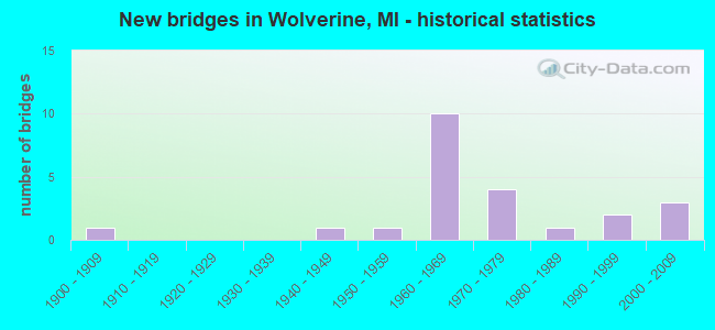
- New bridges - historical statistics
- 11900-1909
- 11940-1949
- 11950-1959
- 101960-1969
- 41970-1979
- 11980-1989
- 21990-1999
- 32000-2009

- Reconstructed bridges - Historical Statistics
- 11990-1999
- 12000-2009
- 22010-2019


- Bridge Condition - Deck
- 5.9%Excellent
- 23.5%Very good
- 29.4%Good
- 17.6%Satisfactory
- 11.8%Fair
- 11.8%Poor

- Bridge Condition - Superstructure
- 41.2%Very good
- 29.4%Good
- 23.5%Satisfactory
- 5.9%Poor

- Bridge Condition - Substructure
- 17.6%Very good
- 29.4%Good
- 35.3%Satisfactory
- 5.9%Fair
- 5.9%Poor
- 5.9%Serious

- Bridge Condition - Channel
- 38.5%Very good
- 30.8%Good
- 15.4%Satisfactory
- 15.4%Fair
Find on map >> Show street view
Structure Number: 156, Location: 6.0 MI N OF WAYLAND (Lat: 42.764381, Lng: -85.672975), Route carried "on" structure: US 131, Year Built: 1958, Year Reconstructed: 2001, Status: Open, Structure Length: 5.63m (18.47ft), Average Daily Traffic: 18,376 (year 2007), Truck Traffic: 13%, Average Future Daily Traffic: 23,284 (year 2018), Design Load: HS 20, Features Intersected: GRAND ELK RR
Minimum Vertical Clearance: 30.48m (100.00ft), Kilometerpoint: 38.626, Lanes on structure: 2, Base Highway Network: Yes (Inventory Route: 78, Subroute: 5), Owner: State Highway Agency, Approaching Roadway Width: 15.2m (49.9ft), Skew: 4 degrees, Material/Design: Prestressed concrete, Design/Construction: Box Beam or Girders - Single/Spread, Number Of Spans In Main Unit: 3, Length of Maximum Span: 20.1m (65.9ft), Curb-To-Curb Width: 15.8m (51.8ft), Out-to-Out Width: 16.9m (55.4ft)
Condition: Deck: Satisfactory, Superstructure: Very good, Substructure: Satisfactory, Operating Rating: 62.5 metric tons, Method Used To Determine Operating Rating: Load Factor (LF) rating reported by rating factor (RF) method using MS18 loading, Inventory Rating: 36.6 metric tons, Method Used To Determine Inventory Rating: Load Factor (LF) rating reported by rating factor (RF) method using MS18 loading, Structural Evaluation: Equal to present minimum criteria, Deck Geometry: Superior to present desirable criteria, Underclear: Superior to present desirable criteria, Approach Roadway Alignment: Equal to present desirable criteria, Length Of Structure Improvement: 5.64m (18.50ft), Designated Inspection Frequency: Every 24 months, Inspection Date: June 2021, Bridge Improvement Cost: $924,000, Roadway Improvement Cost: $13,000, Total Project Cost: $148,000, Deck Structure Type: Concrete Cast-file-Place, Wearing Surface/Protective System: Wearing Surface: Monolithic Concrete, Deck Protection: Epoxy Coated Reinforcing
Find on map >> Show street view
Structure Number: 1521, Location: 2.3 MI N OF OTSEGO COL (Lat: 45.226283, Lng: -84.592767), Route carried "on" structure: Interstate 75, Year Built: 1962, Status: Open, Structure Length: 1.52m (4.99ft), Average Daily Traffic: 7,777 (year 2018), Truck Traffic: 6%, Average Future Daily Traffic: 8,944 (year 2038), Design Load: HS 20+Mod, Features Intersected: STURGEON RIVER
Minimum Vertical Clearance: 30.48m (100.00ft), Kilometerpoint: 3.850, Lanes on structure: 2, Base Highway Network: Yes (Inventory Route: 55, Subroute: 7), Owner: State Highway Agency, Approaching Roadway Width: 13.4m (44.0ft), Skew: 1 degrees, Material/Design: Steel, Design/Construction: Stringer/Multi-beam, Number Of Spans In Main Unit: 1, Length of Maximum Span: 14.5m (47.6ft), Curb-To-Curb Width: 11.7m (38.4ft), Out-to-Out Width: 13.3m (43.6ft)
Condition: Deck: Satisfactory, Superstructure: Satisfactory, Substructure: Satisfactory, Channel: Good, Operating Rating: 94.9 metric tons, Method Used To Determine Operating Rating: Load Factor (LF) rating reported by rating factor (RF) method using MS18 loading, Inventory Rating: 37.3 metric tons, Method Used To Determine Inventory Rating: Load Factor (LF) rating reported by rating factor (RF) method using MS18 loading, Structural Evaluation: Equal to present minimum criteria, Deck Geometry: Equal to present minimum criteria, Waterway Adequacy: Superior to present desirable criteria, Approach Roadway Alignment: Equal to present minimum criteria, Designated Inspection Frequency: Every 24 months, Inspection Date: June 2021, Deck Structure Type: Concrete Cast-file-Place, Wearing Surface/Protective System: Wearing Surface: Epoxy Overlay
Find on map >> Show street view
Structure Number: 1523, Location: 2.5 MI N OF OTSEGO COL (Lat: 45.229808, Lng: -84.587664), Route carried "on" structure: Interstate 75, Year Built: 1962, Year Reconstructed: 2007, Status: Open, Structure Length: 7.67m (25.16ft), Average Daily Traffic: 5,338 (year 2007), Truck Traffic: 12%, Average Future Daily Traffic: 11,700 (year 2028), Design Load: HS 20+Mod, Features Intersected: TROWBRIDGE & D&MRR(ABN)
Minimum Vertical Clearance: 30.48m (100.00ft), Kilometerpoint: 4.410, Lanes on structure: 2, Lanes under structure: 2, Base Highway Network: Yes (Inventory Route: 55, Subroute: 7), Owner: State Highway Agency, Approaching Roadway Width: 13.7m (44.9ft), Skew: 2 degrees, Material/Design: Steel, Design/Construction: Stringer/Multi-beam, Number Of Spans In Main Unit: 4, Length of Maximum Span: 20.7m (67.9ft), Curb-To-Curb Width: 10.1m (33.1ft), Out-to-Out Width: 10.9m (35.8ft)
Condition: Deck: Poor, Superstructure: Good, Substructure: Satisfactory, Operating Rating: 75.5 metric tons, Method Used To Determine Operating Rating: Load Factor (LF) rating reported by rating factor (RF) method using MS18 loading, Inventory Rating: 45.0 metric tons, Method Used To Determine Inventory Rating: Load Factor (LF) rating reported by rating factor (RF) method using MS18 loading, Structural Evaluation: Equal to present minimum criteria, Deck Geometry: Meets minimum limits, Underclear: Somewhat better than minimum adequacy, Approach Roadway Alignment: Equal to present minimum criteria, Designated Inspection Frequency: Every 12 months, Inspection Date: April 2021, Deck Structure Type: Concrete Cast-file-Place, Wearing Surface/Protective System: Wearing Surface: Epoxy Overlay
Find on map >> Show street view
Structure Number: 1527, Location: 6.2 MI S OF M-68 (Lat: 45.316686, Lng: -84.596319), Route carried "on" structure: County highway 1622, Year Built: 1962, Status: Open, Structure Length: 6.64m (21.78ft), Average Daily Traffic: 230 (year 1997), Truck Traffic: 3%, Average Future Daily Traffic: 400 (year 2007), Design Load: H 15, Features Intersected: I-75 SB, Facility Carried by Structure: RONDO RD
Minimum Vertical Clearance: 30.48m (100.00ft), Kilometerpoint: 2.375, Lanes on structure: 2, Lanes under structure: 2, Owner: State Highway Agency, Approaching Roadway Width: 10.0m (32.8ft), Skew: 3 degrees, Material/Design: Steel, Design/Construction: Stringer/Multi-beam, Number Of Spans In Main Unit: 3, Length of Maximum Span: 22.2m (72.8ft), Curb or Sidewalk Widths: Left: 0.7m (2.3ft), Right: 0.7m (2.3ft), Curb-To-Curb Width: 7.3m (24.0ft), Out-to-Out Width: 9.4m (30.8ft)
Condition: Deck: Fair, Superstructure: Satisfactory, Substructure: Good, Operating Rating: 67.4 metric tons, Method Used To Determine Operating Rating: Load Factor (LF) rating reported by rating factor (RF) method using MS18 loading, Inventory Rating: 40.5 metric tons, Method Used To Determine Inventory Rating: Load Factor (LF) rating reported by rating factor (RF) method using MS18 loading, Structural Evaluation: Equal to present minimum criteria, Deck Geometry: Somewhat better than minimum adequacy, Underclear: Somewhat better than minimum adequacy, Approach Roadway Alignment: Somewhat better than minimum adequacy, Designated Inspection Frequency: Every 24 months, Inspection Date: April 2020, Deck Structure Type: Concrete Cast-file-Place, Wearing Surface/Protective System: Wearing Surface: Monolithic Concrete
Find on map >> Show street view
Structure Number: 1528, Location: 6.2 MI S OF M-68 (Lat: 45.316658, Lng: -84.595153), Route carried "on" structure: County highway 1622, Year Built: 1962, Status: Open, Structure Length: 6.64m (21.78ft), Average Daily Traffic: 230 (year 1997), Truck Traffic: 3%, Average Future Daily Traffic: 400 (year 2007), Design Load: H 15, Features Intersected: I-75 NB, Facility Carried by Structure: RONDO RD
Minimum Vertical Clearance: 30.48m (100.00ft), Kilometerpoint: 2.466, Lanes on structure: 2, Lanes under structure: 2, Owner: State Highway Agency, Approaching Roadway Width: 10.0m (32.8ft), Skew: 3 degrees, Material/Design: Steel, Design/Construction: Stringer/Multi-beam, Number Of Spans In Main Unit: 3, Length of Maximum Span: 22.2m (72.8ft), Curb or Sidewalk Widths: Left: 0.7m (2.3ft), Right: 0.7m (2.3ft), Curb-To-Curb Width: 7.3m (24.0ft), Out-to-Out Width: 9.4m (30.8ft)
Condition: Deck: Good, Superstructure: Satisfactory, Substructure: Fair, Operating Rating: 67.4 metric tons, Method Used To Determine Operating Rating: Load Factor (LF) rating reported by rating factor (RF) method using MS18 loading, Inventory Rating: 40.5 metric tons, Method Used To Determine Inventory Rating: Load Factor (LF) rating reported by rating factor (RF) method using MS18 loading, Structural Evaluation: Somewhat better than minimum adequacy, Deck Geometry: Somewhat better than minimum adequacy, Underclear: High priority of corrective action, Approach Roadway Alignment: Somewhat better than minimum adequacy, Designated Inspection Frequency: Every 24 months, Inspection Date: April 2020, Deck Structure Type: Concrete Cast-file-Place, Wearing Surface/Protective System: Wearing Surface: Monolithic Concrete
Find on map >> Show street view
Structure Number: 1532, Location: IN SEC 14 T33NR3W (Lat: 45.255217, Lng: -84.632650), Route carried "on" structure: County highway 1619, Year Built: 1991, Status: Open, Structure Length: 1.37m (4.49ft), Average Daily Traffic: 1,260 (year 2005), Average Future Daily Traffic: 2,300 (year 2025), Design Load: HL 93, Features Intersected: STURGEON RIVER, Facility Carried by Structure: OLD 27
Minimum Vertical Clearance: 30.48m (100.00ft), Kilometerpoint: 6.919, Lanes on structure: 2, Owner: County Highway Agency, Approaching Roadway Width: 9.8m (32.2ft), Skew: 3 degrees, Material/Design: Prestressed concrete, Design/Construction: Box Beam or Girders - Multiple, Number Of Spans In Main Unit: 1, Length of Maximum Span: 13.1m (43.0ft), Curb-To-Curb Width: 12.5m (41.0ft), Out-to-Out Width: 13.2m (43.3ft)
Condition: Deck: Poor, Superstructure: Good, Substructure: Satisfactory, Channel: Satisfactory, Operating Rating: 73.5 metric tons, Method Used To Determine Operating Rating: Load and Resistance Factor Rating (LRFR) rating reported by rating factor(RF) method using HL-93 loadings, Inventory Rating: 55.7 metric tons, Method Used To Determine Inventory Rating: Load and Resistance Factor Rating (LRFR) rating reported by rating factor(RF) method using HL-93 loadings, Structural Evaluation: Equal to present minimum criteria, Deck Geometry: Better than present minimum criteria, Waterway Adequacy: Equal to present desirable criteria, Approach Roadway Alignment: Equal to present desirable criteria, Designated Inspection Frequency: Every 24 months, Inspection Date: July 2021, Deck Structure Type: Concrete Cast-file-Place, Wearing Surface/Protective System: Wearing Surface: Monolithic Concrete, Deck Protection: Epoxy Coated Reinforcing
Find on map >> Show street view
Structure Number: 1539, Location: SEC 29 T33NR2W (Lat: 45.222292, Lng: -84.588150), Route carried "on" structure: County highway 1631, Year Built: 1977, Status: Posted for load, Structure Length: 1.34m (4.40ft), Average Daily Traffic: 400 (year 2005), Average Future Daily Traffic: 730 (year 2025), Design Load: HS 20+Mod, Features Intersected: STURGEON RIVER, Facility Carried by Structure: TROWBRIDGE ROAD
Minimum Vertical Clearance: 30.48m (100.00ft), Kilometerpoint: 5.810, Lanes on structure: 2, Owner: County Highway Agency, Approaching Roadway Width: 9.1m (29.9ft), Skew: 1 degrees, Material/Design: Prestressed concrete, Design/Construction: Box Beam or Girders - Multiple, Number Of Spans In Main Unit: 1, Length of Maximum Span: 12.2m (40.0ft), Curb-To-Curb Width: 9.1m (29.9ft), Out-to-Out Width: 9.2m (30.2ft)
Condition: Deck: Good, Superstructure: Good, Substructure: Good, Channel: Satisfactory, Operating Rating: 37.6 metric tons, Method Used To Determine Operating Rating: Load and Resistance Factor Rating (LRFR) rating reported by rating factor(RF) method using HL-93 loadings, Inventory Rating: 28.8 metric tons, Method Used To Determine Inventory Rating: Load and Resistance Factor Rating (LRFR) rating reported by rating factor(RF) method using HL-93 loadings, Structural Evaluation: Better than present minimum criteria, Deck Geometry: Equal to present minimum criteria, Waterway Adequacy: Equal to present desirable criteria, Approach Roadway Alignment: Equal to present desirable criteria, Bridge Posting: Required (Relationship of Operating Rating to Maximum Legal Load: 20.0 - 29.9% below), Designated Inspection Frequency: Every 24 months, Inspection Date: July 2021, Deck Structure Type: Concrete Cast-file-Place, Wearing Surface/Protective System: Wearing Surface: Bituminous, Membrane: Preformed Fabric
Find on map >> Show street view
Structure Number: 154, Location: SEC 20 T33NR2W (Lat: 45.232022, Lng: -84.588486), Route carried "on" structure: County highway 1631, Year Built: 1977, Status: Posted for load, Structure Length: 1.58m (5.18ft), Average Daily Traffic: 410 (year 2005), Average Future Daily Traffic: 730 (year 2025), Design Load: HS 20+Mod, Features Intersected: STURGEON RIVER, Facility Carried by Structure: TROWBRIDGE ROAD
Minimum Vertical Clearance: 30.48m (100.00ft), Kilometerpoint: 6.912, Lanes on structure: 2, Owner: County Highway Agency, Approaching Roadway Width: 9.1m (29.9ft), Material/Design: Prestressed concrete, Design/Construction: Box Beam or Girders - Multiple, Number Of Spans In Main Unit: 1, Length of Maximum Span: 14.6m (47.9ft), Curb-To-Curb Width: 9.1m (29.9ft), Out-to-Out Width: 9.2m (30.2ft)
Condition: Deck: Good, Superstructure: Good, Substructure: Good, Channel: Good, Operating Rating: 39.5 metric tons, Method Used To Determine Operating Rating: Load and Resistance Factor Rating (LRFR) rating reported by rating factor(RF) method using HL-93 loadings, Inventory Rating: 30.5 metric tons, Method Used To Determine Inventory Rating: Load and Resistance Factor Rating (LRFR) rating reported by rating factor(RF) method using HL-93 loadings, Structural Evaluation: Better than present minimum criteria, Deck Geometry: Equal to present minimum criteria, Waterway Adequacy: Equal to present desirable criteria, Approach Roadway Alignment: Equal to present desirable criteria, Bridge Posting: Required (Relationship of Operating Rating to Maximum Legal Load: 20.0 - 29.9% below), Designated Inspection Frequency: Every 24 months, Inspection Date: July 2021, Deck Structure Type: Concrete Cast-file-Place, Wearing Surface/Protective System: Wearing Surface: Bituminous, Membrane: Preformed Fabric
Find on map >> Show street view
Structure Number: 1541, Location: BETWEEN SEC. 24&25 T34R3W (Lat: 45.316808, Lng: -84.622383), Route carried "on" structure: County highway 1622, Year Built: 1979, Status: Open, Structure Length: 2.37m (7.78ft), Average Daily Traffic: 640 (year 2005), Average Future Daily Traffic: 1,100 (year 2025), Design Load: HS 20+Mod, Features Intersected: STURGEON RIVER, Facility Carried by Structure: RONDO ROAD
Minimum Vertical Clearance: 30.48m (100.00ft), Kilometerpoint: 0.187, Lanes on structure: 2, Owner: County Highway Agency, Approaching Roadway Width: 9.8m (32.2ft), Material/Design: Prestressed concrete, Design/Construction: Box Beam or Girders - Multiple, Number Of Spans In Main Unit: 1, Length of Maximum Span: 23.7m (77.8ft), Curb-To-Curb Width: 9.1m (29.9ft), Out-to-Out Width: 9.2m (30.2ft)
Condition: Deck: Good, Superstructure: Good, Substructure: Satisfactory, Channel: Good, Operating Rating: 66.4 metric tons, Method Used To Determine Operating Rating: Load Factor (LF) rating reported by rating factor (RF) method using MS18 loading, Inventory Rating: 36.9 metric tons, Method Used To Determine Inventory Rating: Load Factor (LF) rating reported by rating factor (RF) method using MS18 loading, Structural Evaluation: Equal to present minimum criteria, Deck Geometry: Equal to present minimum criteria, Waterway Adequacy: Equal to present desirable criteria, Approach Roadway Alignment: Equal to present desirable criteria, Designated Inspection Frequency: Every 24 months, Inspection Date: July 2021, Deck Structure Type: Concrete Cast-file-Place, Wearing Surface/Protective System: Wearing Surface: Bituminous
Find on map >> Show street view
Structure Number: 1544, Location: SEC.31,T34N,R2W (Lat: 45.291361, Lng: -84.605517), Route carried "on" structure: County highway , Year Built: 2003, Status: Posted for load, Structure Length: 2.26m (7.41ft), Average Daily Traffic: 220 (year 2005), Average Future Daily Traffic: 400 (year 2025), Design Load: HS 20, Features Intersected: STURGEON RIVER, Facility Carried by Structure: SCOTT ROAD
Minimum Vertical Clearance: 30.48m (100.00ft), Kilometerpoint: 0.288, Lanes on structure: 2, Owner: County Highway Agency, Approaching Roadway Width: 7.3m (24.0ft), Material/Design: Prestressed concrete, Design/Construction: Box Beam or Girders - Multiple, Number Of Spans In Main Unit: 1, Length of Maximum Span: 21.6m (70.9ft), Curb-To-Curb Width: 9.8m (32.2ft), Out-to-Out Width: 10.5m (34.4ft)
Condition: Deck: Very good, Superstructure: Very good, Substructure: Very good, Channel: Very good, Operating Rating: 58.0 metric tons, Method Used To Determine Operating Rating: Load Factor (LF) rating reported by rating factor (RF) method using MS18 loading, Inventory Rating: 29.2 metric tons, Method Used To Determine Inventory Rating: Load Factor (LF) rating reported by rating factor (RF) method using MS18 loading, Structural Evaluation: Better than present minimum criteria, Deck Geometry: Better than present minimum criteria, Waterway Adequacy: Equal to present desirable criteria, Approach Roadway Alignment: Equal to present minimum criteria, Bridge Posting: Required (Relationship of Operating Rating to Maximum Legal Load: 0.1 - 9.9% below), Designated Inspection Frequency: Every 24 months, Inspection Date: July 2021, Deck Structure Type: Concrete Cast-file-Place, Wearing Surface/Protective System: Wearing Surface: Monolithic Concrete, Deck Protection: Epoxy Coated Reinforcing
Find on map >> Show street view
Structure Number: 1549, Location: SEC 20 T33N R2W (Lat: 45.236633, Lng: -84.586078), Route carried "on" structure: County highway , Year Built: 1978, Year Reconstructed: 2010, Status: Posted for load, Structure Length: 1.07m (3.51ft), Average Daily Traffic: 30 (year 2005), Average Future Daily Traffic: 50 (year 2025), Design Load: HS 20+Mod, Features Intersected: STURGEON RIVER, Facility Carried by Structure: FREEWAY TRAIL
Minimum Vertical Clearance: 30.48m (100.00ft), Kilometerpoint: 0.332, Lanes on structure: 1, Owner: County Highway Agency, Approaching Roadway Width: 6.1m (20.0ft), Material/Design: Steel, Design/Construction: Stringer/Multi-beam, Number Of Spans In Main Unit: 1, Length of Maximum Span: 10.4m (34.1ft), Curb-To-Curb Width: 3.5m (11.5ft), Out-to-Out Width: 3.7m (12.1ft)
Condition: Deck: Excellent, Superstructure: Very good, Substructure: Serious, Channel: Fair, Operating Rating: 39.5 metric tons, Method Used To Determine Operating Rating: Load Factor (LF) rating reported by rating factor (RF) method using MS18 loading, Inventory Rating: 23.7 metric tons, Method Used To Determine Inventory Rating: Load Factor (LF) rating reported by rating factor (RF) method using MS18 loading, Structural Evaluation: High priority of corrective action, Deck Geometry: High priority of corrective action, Waterway Adequacy: Equal to present minimum criteria, Approach Roadway Alignment: Meets minimum limits, Bridge Posting: Required (Relationship of Operating Rating to Maximum Legal Load: > 39.9% below), Length Of Structure Improvement: 1.00m (3.28ft), Designated Inspection Frequency: Every 12 months, Inspection Date: July 2021, Bridge Improvement Cost: $60,000, Roadway Improvement Cost: $15,000, Total Project Cost: $75,000, Deck Structure Type: Wood or Timber, Wearing Surface/Protective System: Wearing Surface: Wood or Timber
Find on map >> Show street view
Structure Number: 1556, Location: WILMOT TWP SEC 16 (Lat: 45.248908, Lng: -84.676617), Route carried "on" structure: County highway , Year Built: 2008, Status: Open, Structure Length: 1.52m (4.99ft), Average Daily Traffic: 180 (year 2007), Average Future Daily Traffic: 325 (year 2027), Design Load: HS 20+Mod, Features Intersected: W BR STURGEON RIVER, Facility Carried by Structure: MC EACHRON ROAD
Minimum Vertical Clearance: 30.48m (100.00ft), Kilometerpoint: 1.579, Lanes on structure: 2, Owner: County Highway Agency, Approaching Roadway Width: 6.1m (20.0ft), Skew: 3 degrees, Material/Design: Prestressed concrete, Design/Construction: Box Beam or Girders - Multiple, Number Of Spans In Main Unit: 1, Length of Maximum Span: 14.0m (45.9ft), Curb-To-Curb Width: 7.9m (25.9ft), Out-to-Out Width: 8.6m (28.2ft)
Condition: Deck: Very good, Superstructure: Very good, Substructure: Very good, Channel: Very good, Operating Rating: 53.8 metric tons, Method Used To Determine Operating Rating: Load and Resistance Factor Rating (LRFR) rating reported by rating factor(RF) method using HL-93 loadings, Inventory Rating: 41.5 metric tons, Method Used To Determine Inventory Rating: Load and Resistance Factor Rating (LRFR) rating reported by rating factor(RF) method using HL-93 loadings, Structural Evaluation: Equal to present desirable criteria, Deck Geometry: Somewhat better than minimum adequacy, Waterway Adequacy: Meets minimum limits, Approach Roadway Alignment: Somewhat better than minimum adequacy, Designated Inspection Frequency: Every 24 months, Inspection Date: July 2021, Deck Structure Type: Concrete Cast-file-Place, Wearing Surface/Protective System: Wearing Surface: Monolithic Concrete, Deck Protection: Epoxy Coated Reinforcing
Find on map >> Show street view
Structure Number: 1557, Location: SEC.14/15,T33N,R3W (Lat: 45.249375, Lng: -84.651972), Route carried "on" structure: County highway , Year Built: 1994, Status: Open, Structure Length: 1.82m (5.97ft), Average Daily Traffic: 240 (year 2005), Average Future Daily Traffic: 430 (year 2025), Design Load: HS 20, Features Intersected: W BR STURGEON RIVER, Facility Carried by Structure: OLD STURGEON RD
Minimum Vertical Clearance: 30.48m (100.00ft), Kilometerpoint: 1.989, Lanes on structure: 2, Owner: County Highway Agency, Approaching Roadway Width: 9.1m (29.9ft), Material/Design: Prestressed concrete, Design/Construction: Box Beam or Girders - Multiple, Number Of Spans In Main Unit: 1, Length of Maximum Span: 17.0m (55.8ft), Curb-To-Curb Width: 9.8m (32.2ft), Out-to-Out Width: 10.4m (34.1ft)
Condition: Deck: Satisfactory, Superstructure: Very good, Substructure: Good, Channel: Good, Operating Rating: 39.9 metric tons, Method Used To Determine Operating Rating: Load and Resistance Factor Rating (LRFR) rating reported by rating factor(RF) method using HL-93 loadings, Inventory Rating: 25.9 metric tons, Method Used To Determine Inventory Rating: Load and Resistance Factor Rating (LRFR) rating reported by rating factor(RF) method using HL-93 loadings, Structural Evaluation: Equal to present minimum criteria, Deck Geometry: Better than present minimum criteria, Waterway Adequacy: Equal to present desirable criteria, Approach Roadway Alignment: Equal to present desirable criteria, Designated Inspection Frequency: Every 24 months, Inspection Date: July 2021, Deck Structure Type: Concrete Cast-file-Place, Wearing Surface/Protective System: Wearing Surface: Monolithic Concrete, Deck Protection: Epoxy Coated Reinforcing
Find on map >> Show street view
Structure Number: 1558, Location: SEC.12,T33N,R3W (Lat: 45.260481, Lng: -84.620803), Route carried "on" structure: County highway , Year Built: 2005, Status: Open, Structure Length: 1.22m (4.00ft), Average Daily Traffic: 144 (year 2005), Average Future Daily Traffic: 260 (year 2025), Design Load: HS 20+Mod, Features Intersected: W BR STURGEON RIVER, Facility Carried by Structure: SHIRE ROAD
Minimum Vertical Clearance: 30.48m (100.00ft), Kilometerpoint: 9.682, Lanes on structure: 2, Owner: County Highway Agency, Approaching Roadway Width: 9.1m (29.9ft), Skew: 1 degrees, Material/Design: Prestressed concrete, Design/Construction: Box Beam or Girders - Multiple, Number Of Spans In Main Unit: 1, Length of Maximum Span: 11.0m (36.1ft), Curb-To-Curb Width: 9.1m (29.9ft), Out-to-Out Width: 10.0m (32.8ft)
Condition: Deck: Very good, Superstructure: Very good, Substructure: Very good, Channel: Very good, Operating Rating: 68.4 metric tons, Method Used To Determine Operating Rating: Load and Resistance Factor Rating (LRFR) rating reported by rating factor(RF) method using HL-93 loadings, Inventory Rating: 52.8 metric tons, Method Used To Determine Inventory Rating: Load and Resistance Factor Rating (LRFR) rating reported by rating factor(RF) method using HL-93 loadings, Structural Evaluation: Equal to present desirable criteria, Deck Geometry: Equal to present minimum criteria, Waterway Adequacy: Better than present minimum criteria, Approach Roadway Alignment: Equal to present desirable criteria, Designated Inspection Frequency: Every 24 months, Inspection Date: July 2021, Deck Structure Type: Concrete Cast-file-Place, Wearing Surface/Protective System: Wearing Surface: Bituminous, Membrane: Preformed Fabric
Find on map >> Show street view
Structure Number: 156, Location: IN WOLVERINE (Lat: 45.271192, Lng: -84.602536), Route carried "on" structure: City street 653, Year Built: 1949, Status: Open, Structure Length: 0.94m (3.08ft), Average Daily Traffic: 520 (year 2017), Average Future Daily Traffic: 650 (year 2037), Design Load: HS 20+Mod, Features Intersected: W BR STURGEON RIVER, Facility Carried by Structure: TROWBRIDGE ROAD
Minimum Vertical Clearance: 30.48m (100.00ft), Kilometerpoint: 11.491, Lanes on structure: 2, Owner: City or Municipal Highway Agency, Approaching Roadway Width: 12.2m (40.0ft), Material/Design: Steel, Design/Construction: Stringer/Multi-beam, Number Of Spans In Main Unit: 1, Length of Maximum Span: 8.8m (28.9ft), Curb or Sidewalk Widths: Left: 0.6m (2.0ft), Right: 0.6m (2.0ft), Curb-To-Curb Width: 6.7m (22.0ft), Out-to-Out Width: 8.5m (27.9ft)
Condition: Deck: Fair, Superstructure: Poor, Substructure: Good, Channel: Very good, Operating Rating: 50.9 metric tons, Method Used To Determine Operating Rating: Load Factor (LF) rating reported by rating factor (RF) method using MS18 loading, Inventory Rating: 30.5 metric tons, Method Used To Determine Inventory Rating: Load Factor (LF) rating reported by rating factor (RF) method using MS18 loading, Structural Evaluation: Meets minimum limits, Deck Geometry: Meets minimum limits, Waterway Adequacy: Equal to present desirable criteria, Approach Roadway Alignment: Equal to present minimum criteria, Designated Inspection Frequency: Every 24 months, Inspection Date: October 2021, Deck Structure Type: Concrete Cast-file-Place, Wearing Surface/Protective System: Wearing Surface: Monolithic Concrete
Find on map >> Show street view
Structure Number: 1561, Location: IN WOLVERINE (Lat: 45.273153, Lng: -84.600608), Route carried "on" structure: City street 1641, Year Built: 1987, Status: Open, Structure Length: 1.22m (4.00ft), Average Daily Traffic: 800 (year 2017), Average Future Daily Traffic: 1,100 (year 2037), Design Load: HS 20+Mod, Features Intersected: STURGEON RIVER, Facility Carried by Structure: EAST MAIN STREET
Minimum Vertical Clearance: 30.48m (100.00ft), Kilometerpoint: 0.295, Lanes on structure: 2, Owner: City or Municipal Highway Agency, Approaching Roadway Width: 12.8m (42.0ft), Material/Design: Prestressed concrete, Design/Construction: Box Beam or Girders - Multiple, Number Of Spans In Main Unit: 1, Length of Maximum Span: 12.2m (40.0ft), Curb or Sidewalk Widths: Left: 1.5m (4.9ft), Right: 1.5m (4.9ft), Curb-To-Curb Width: 9.4m (30.8ft), Out-to-Out Width: 13.7m (44.9ft)
Condition: Deck: Good, Superstructure: Satisfactory, Substructure: Satisfactory, Channel: Very good, Operating Rating: 72.3 metric tons, Method Used To Determine Operating Rating: Load Factor (LF) rating reported by rating factor (RF) method using MS18 loading, Inventory Rating: 43.4 metric tons, Method Used To Determine Inventory Rating: Load Factor (LF) rating reported by rating factor (RF) method using MS18 loading, Structural Evaluation: Equal to present minimum criteria, Deck Geometry: Equal to present minimum criteria, Waterway Adequacy: Equal to present desirable criteria, Approach Roadway Alignment: Equal to present desirable criteria, Designated Inspection Frequency: Every 24 months, Inspection Date: October 2021, Deck Structure Type: Concrete Cast-file-Place, Wearing Surface/Protective System: Wearing Surface: Bituminous, Deck Protection: Epoxy Coated Reinforcing
Find on map >> Show street view
Structure Number: 1562, Location: VILLAGE OF WOLVERINE (Lat: 45.274967, Lng: -84.600036), Route carried "on" structure: County highway , Year Built: 1900, Year Reconstructed: 2019, Status: Posted for load, Structure Length: 1.58m (5.18ft), Average Daily Traffic: 25 (year 2015), Average Future Daily Traffic: 30 (year 2035), Design Load: HL 93, Features Intersected: STURGEON RIVER, Facility Carried by Structure: NEW NATURE AVE
Minimum Vertical Clearance: 30.48m (100.00ft), Kilometerpoint: 0.533, Lanes on structure: 1, Owner: City or Municipal Highway Agency, Approaching Roadway Width: 3.7m (12.1ft), Material/Design: Steel, Design/Construction: Stringer/Multi-beam, Number Of Spans In Main Unit: 3, Length of Maximum Span: 4.2m (13.8ft), Curb-To-Curb Width: 3.3m (10.8ft), Out-to-Out Width: 3.7m (12.1ft)
Condition: Deck: Very good, Superstructure: Very good, Substructure: Poor, Channel: Fair, Operating Rating: 24.9 metric tons, Method Used To Determine Operating Rating: Load and Resistance Factor Rating (LRFR) rating reported by rating factor(RF) method using HL-93 loadings, Inventory Rating: 19.4 metric tons, Method Used To Determine Inventory Rating: Load and Resistance Factor Rating (LRFR) rating reported by rating factor(RF) method using HL-93 loadings, Structural Evaluation: Meets minimum limits, Deck Geometry: High priority of replacement, Waterway Adequacy: Meets minimum limits, Approach Roadway Alignment: Equal to present desirable criteria, Bridge Posting: Required (Relationship of Operating Rating to Maximum Legal Load: > 39.9% below), Designated Inspection Frequency: Every 12 months, Inspection Date: October 2021, Deck Structure Type: Wood or Timber, Wearing Surface/Protective System: Wearing Surface: Wood or Timber
Find on map >> Show street view
Structure Number: 1523, Location: 2.5 MI N OF OTSEGO COL (Lat: 45.229808, Lng: -84.587664), Route carried "under" structure: County highway 1631, Year Built: 1962, Structure Length: 0. m, Average Daily Traffic: 200 (year 1997), Truck Traffic: 3%, Features Intersected: TROWBRIDGE & D&MRR(ABN), Facility Carried by Structure: I-75 SB
Minimum Vertical Clearance: 6.12m (20.08ft), Kilometerpoint: 6.658, Lanes on structure: 2, Lanes under structure: 2, Material/Design: Steel, Design/Construction: Stringer/Multi-beam, Length of Maximum Span: 20.7m (67.9ft)
Find on map >> Show street view
Structure Number: 1524, Location: 2.5 MI N OF OTSEGO COL (Lat: 45.229364, Lng: -84.587486), Route carried "under" structure: County highway 1631, Year Built: 1962, Structure Length: 0. m, Average Daily Traffic: 200 (year 1997), Truck Traffic: 3%, Features Intersected: TROWBRIDGE & D&MRR(ABN), Facility Carried by Structure: I-75 NB
Minimum Vertical Clearance: 6.12m (20.08ft), Kilometerpoint: 6.607, Lanes on structure: 2, Lanes under structure: 2, Material/Design: Steel, Design/Construction: Stringer/Multi-beam, Length of Maximum Span: 20.7m (67.9ft)
Find on map >> Show street view
Structure Number: 1525, Location: 5.8 MI N OF OTSEGO COL (Lat: 45.273178, Lng: -84.592539), Route carried "under" structure: Interstate 75, Year Built: 1962, Structure Length: 0. m, Average Daily Traffic: 5,338 (year 2007), Truck Traffic: 9%, Features Intersected: I-75 SB, Facility Carried by Structure: WEBB RD
Minimum Vertical Clearance: 5.03m (16.50ft), Kilometerpoint: 9.597, Lanes on structure: 2, Lanes under structure: 2, Material/Design: Prestressed concrete, Design/Construction: Stringer/Multi-beam, Length of Maximum Span: 17.6m (57.7ft)
Find on map >> Show street view
Structure Number: 1526, Location: 5.8 MI N OF OTSEGO COL (Lat: 45.273161, Lng: -84.591592), Route carried "under" structure: Interstate 75, Year Built: 1962, Structure Length: 0. m, Average Daily Traffic: 5,338 (year 2007), Truck Traffic: 9%, Features Intersected: I-75 NB, Facility Carried by Structure: WEBB RD
Minimum Vertical Clearance: 5.00m (16.40ft), Kilometerpoint: 9.500, Lanes on structure: 2, Lanes under structure: 2, Material/Design: Prestressed concrete, Design/Construction: Stringer/Multi-beam, Length of Maximum Span: 17.6m (57.7ft)
Find on map >> Show street view
Structure Number: 1527, Location: 6.2 MI S OF M-68 (Lat: 45.316686, Lng: -84.596319), Route carried "under" structure: Interstate 75, Year Built: 1962, Structure Length: 0. m, Average Daily Traffic: 4,809 (year 2007), Truck Traffic: 9%, Features Intersected: I-75 SB, Facility Carried by Structure: RONDO RD
Minimum Vertical Clearance: 4.98m (16.34ft), Kilometerpoint: 14.565, Lanes on structure: 2, Lanes under structure: 2, Material/Design: Steel, Design/Construction: Stringer/Multi-beam, Length of Maximum Span: 22.2m (72.8ft)
Find on map >> Show street view
Structure Number: 1528, Location: 6.2 MI S OF M-68 (Lat: 45.316658, Lng: -84.595153), Route carried "under" structure: Interstate 75, Year Built: 1962, Structure Length: 0. m, Average Daily Traffic: 4,809 (year 2007), Truck Traffic: 9%, Features Intersected: I-75 NB, Facility Carried by Structure: RONDO RD
Minimum Vertical Clearance: 5.08m (16.67ft), Kilometerpoint: 14.462, Lanes on structure: 2, Lanes under structure: 2, Material/Design: Steel, Design/Construction: Stringer/Multi-beam, Length of Maximum Span: 22.2m (72.8ft)