Bridge Statistics for Woodburn, Oregon (OR)
Condition, Traffic, Stress, Structural Evaluation, Project Costs
- National Bridge Inventory (NBI) Statistics
- 23Number of bridges
- 292ft / 89.0mTotal length
- $12,625,000Total costs
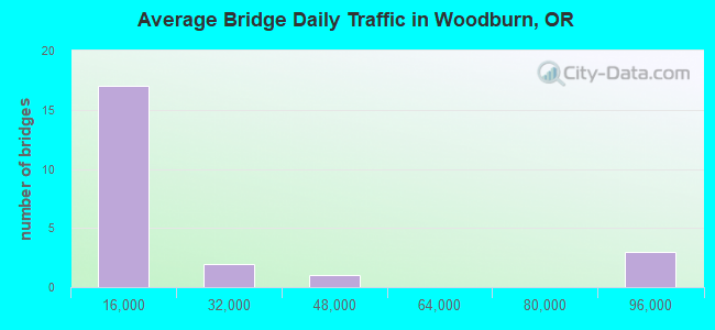
- 412,263Total average daily traffic
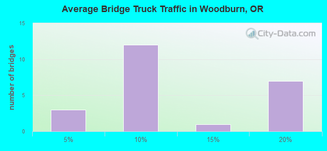
- 63,585Total average daily truck traffic
- National Bridge Inventory (NBI) Registered Bridges for Woodburn
- No street view available for this location
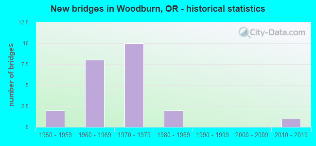
- New bridges - historical statistics
- 21950-1959
- 81960-1969
- 101970-1979
- 21980-1989
- 12010-2019
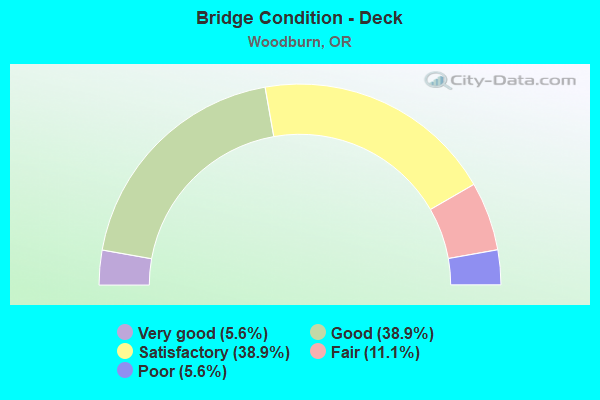
- Bridge Condition - Deck
- 5.6%Very good
- 38.9%Good
- 38.9%Satisfactory
- 11.1%Fair
- 5.6%Poor
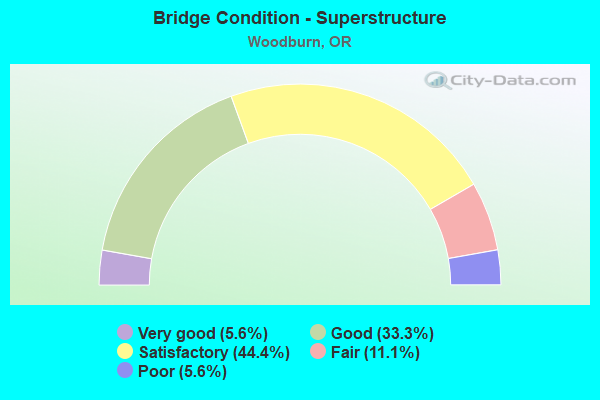
- Bridge Condition - Superstructure
- 5.6%Very good
- 33.3%Good
- 44.4%Satisfactory
- 11.1%Fair
- 5.6%Poor
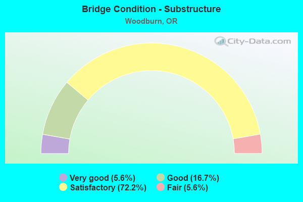
- Bridge Condition - Substructure
- 5.6%Very good
- 16.7%Good
- 72.2%Satisfactory
- 5.6%Fair
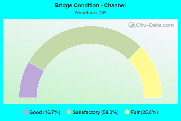
- Bridge Condition - Channel
- 16.7%Good
- 58.3%Satisfactory
- 25.0%Fair
Find on map >> Show street view
Structure Number: 1557A417, Location: 034 MI SW DONALD (Lat: 45.191281, Lng: -122.889369), Route carried "on" structure: County highway C0417, Year Built: 1963, Status: Posted for load, Structure Length: 2.74m (8.99ft), Average Daily Traffic: 1,567 (year 2020), Truck Traffic: 4%, Average Future Daily Traffic: 1,762 (year 2025), Design Load: HS 20, Features Intersected: CASE CREEK, Facility Carried by Structure: BROADACRES RD
Minimum Vertical Clearance: 30+ m (98+ ft), Kilometerpoint: 0.563, Lanes on structure: 2, Owner: County Highway Agency, Approaching Roadway Width: 7.0m (23.0ft), Material/Design: Concrete, Design/Construction: Tee Beam, Number Of Spans In Main Unit: 4, Length of Maximum Span: 6.7m (22.0ft), Curb-To-Curb Width: 7.3m (24.0ft), Out-to-Out Width: 8.8m (28.9ft)
Condition: Deck: Good, Superstructure: Good, Substructure: Satisfactory, Channel: Satisfactory, Operating Rating: 28.8 metric tons, Method Used To Determine Operating Rating: Field evaluation and documented engineering judgment, Inventory Rating: 22.2 metric tons, Method Used To Determine Inventory Rating: Field evaluation and documented engineering judgment, Structural Evaluation: Somewhat better than minimum adequacy, Deck Geometry: Meets minimum limits, Waterway Adequacy: Equal to present desirable criteria, Approach Roadway Alignment: Equal to present desirable criteria, Bridge Posting: Required (Relationship of Operating Rating to Maximum Legal Load: 10.0 - 19.9% below), Designated Inspection Frequency: Every 24 months, Underwater Inspection Frequency: Every 60 months, Inspection Date: August 2020, Underwater Inspection Date: April 2021, Deck Structure Type: Concrete Cast-file-Place, Wearing Surface/Protective System: Wearing Surface: Bituminous
Find on map >> Show street view
Structure Number: 1917A140 04078, Location: 040 MI SW WOODBURN (Lat: 45.126150, Lng: -122.820061), Route carried "on" structure: State highway 214, Year Built: 1982, Status: Open, Structure Length: 9.72m (31.89ft), Average Daily Traffic: 5,445 (year 2020), Truck Traffic: 7%, Average Future Daily Traffic: 6,300 (year 2040), Design Load: HS 25 or greater, Features Intersected: Pudding River
Minimum Vertical Clearance: 30+ m (98+ ft), Kilometerpoint: 65.661, Lanes on structure: 2, Base Highway Network: Yes, Owner: State Highway Agency, Approaching Roadway Width: 12.2m (40.0ft), Skew: 1 degrees, Material/Design: Prestressed concrete, Design/Construction: Box Beam or Girders - Multiple, Number Of Spans In Main Unit: 1, Number Of Approach Spans: 4, Length of Maximum Span: 32.6m (107.0ft), Curb-To-Curb Width: 12.2m (40.0ft), Out-to-Out Width: 13.4m (44.0ft)
Condition: Deck: Good, Superstructure: Satisfactory, Substructure: Satisfactory, Channel: Satisfactory, Operating Rating: 51.2 metric tons, Method Used To Determine Operating Rating: Load and Resistance Factor Rating (LRFR) rating reported by rating factor(RF) method using HL-93 loadings, Inventory Rating: 39.5 metric tons, Method Used To Determine Inventory Rating: Load and Resistance Factor Rating (LRFR) rating reported by rating factor(RF) method using HL-93 loadings, Structural Evaluation: Equal to present minimum criteria, Deck Geometry: Somewhat better than minimum adequacy, Waterway Adequacy: Equal to present desirable criteria, Approach Roadway Alignment: Equal to present desirable criteria, Designated Inspection Frequency: Every 24 months, Inspection Date: September 2021, Deck Structure Type: Concrete Precast Panels, Wearing Surface/Protective System: Wearing Surface: Bituminous, Membrane: Built-up
Find on map >> Show street view
Structure Number: 2284 140 03373, Location: 030 MI S WOODBURN (Lat: 45.165539, Lng: -122.932511), Route carried "on" structure: State highway 219, Year Built: 1959, Status: Open, Structure Length: 1.92m (6.30ft), Average Daily Traffic: 1,860 (year 2020), Truck Traffic: 16%, Average Future Daily Traffic: 2,200 (year 2040), Design Load: HS 20, Features Intersected: East Champoeg Creek
Minimum Vertical Clearance: 30+ m (98+ ft), Kilometerpoint: 54.251, Lanes on structure: 2, Base Highway Network: Yes, Owner: State Highway Agency, Approaching Roadway Width: 8.0m (26.2ft), Material/Design: Concrete, Design/Construction: Channel Beam, Number Of Spans In Main Unit: 3, Length of Maximum Span: 6.4m (21.0ft), Curb-To-Curb Width: 8.0m (26.2ft), Out-to-Out Width: 9.4m (30.8ft)
Condition: Deck: Good, Superstructure: Satisfactory, Substructure: Satisfactory, Channel: Good, Operating Rating: 25.3 metric tons, Method Used To Determine Operating Rating: Load and Resistance Factor Rating (LRFR) rating reported by rating factor(RF) method using HL-93 loadings, Inventory Rating: 19.4 metric tons, Method Used To Determine Inventory Rating: Load and Resistance Factor Rating (LRFR) rating reported by rating factor(RF) method using HL-93 loadings, Structural Evaluation: Somewhat better than minimum adequacy, Deck Geometry: Meets minimum limits, Waterway Adequacy: Equal to present desirable criteria, Approach Roadway Alignment: Equal to present desirable criteria, Length Of Structure Improvement: 1.90m (6.23ft), Designated Inspection Frequency: Every 24 months, Inspection Date: September 2021, Bridge Improvement Cost: $202,000, Roadway Improvement Cost: $20,000, Total Project Cost: $323,000, Deck Structure Type: Concrete Precast Panels, Wearing Surface/Protective System: Wearing Surface: Bituminous
Find on map >> Show street view
Structure Number: 4442A140 03608, Location: 001 WEST OF WOODBURN (Lat: 45.150939, Lng: -122.895731), Route carried "on" structure: State highway 219, Year Built: 1985, Status: Open, Structure Length: 1.37m (4.49ft), Average Daily Traffic: 5,943 (year 2020), Truck Traffic: 16%, Average Future Daily Traffic: 8,700 (year 2040), Design Load: HS 25 or greater, Features Intersected: Senecal Creek, Facility Carried by Structure: HWY 140
Minimum Vertical Clearance: 30+ m (98+ ft), Kilometerpoint: 58.033, Lanes on structure: 2, Base Highway Network: Yes, Owner: State Highway Agency, Approaching Roadway Width: 11.9m (39.0ft), Skew: 1 degrees, Material/Design: Prestressed concrete, Design/Construction: Slab, Number Of Spans In Main Unit: 1, Length of Maximum Span: 13.7m (44.9ft), Curb-To-Curb Width: 11.9m (39.0ft), Out-to-Out Width: 12.2m (40.0ft)
Condition: Deck: Good, Superstructure: Good, Substructure: Good, Channel: Good, Operating Rating: 47.3 metric tons, Method Used To Determine Operating Rating: Load and Resistance Factor Rating (LRFR) rating reported by rating factor(RF) method using HL-93 loadings, Inventory Rating: 36.6 metric tons, Method Used To Determine Inventory Rating: Load and Resistance Factor Rating (LRFR) rating reported by rating factor(RF) method using HL-93 loadings, Structural Evaluation: Better than present minimum criteria, Deck Geometry: Somewhat better than minimum adequacy, Waterway Adequacy: Equal to present desirable criteria, Approach Roadway Alignment: Equal to present desirable criteria, Designated Inspection Frequency: Every 24 months, Inspection Date: September 2021, Deck Structure Type: Concrete Precast Panels, Wearing Surface/Protective System: Wearing Surface: Bituminous, Membrane: Built-up
Find on map >> Show street view
Structure Number: 5140A008, Location: 00.5 EAST OF BROADACRES (Lat: 45.186400, Lng: -122.859469), Route carried "on" structure: County highway A0598, Year Built: 1960, Status: Posted for load, Structure Length: 1.40m (4.59ft), Average Daily Traffic: 4,795 (year 2020), Truck Traffic: 15%, Average Future Daily Traffic: 5,000 (year 2040), Design Load: HS 20, Features Intersected: SENECAL CREEK, Facility Carried by Structure: BROADACRES ROAD
Minimum Vertical Clearance: 30+ m (98+ ft), Kilometerpoint: 4.345, Lanes on structure: 2, Owner: County Highway Agency, Approaching Roadway Width: 7.3m (24.0ft), Material/Design: Concrete, Design/Construction: Tee Beam, Number Of Spans In Main Unit: 2, Length of Maximum Span: 6.7m (22.0ft), Curb-To-Curb Width: 7.4m (24.3ft), Out-to-Out Width: 8.8m (28.9ft)
Condition: Deck: Fair, Superstructure: Fair, Substructure: Satisfactory, Channel: Fair, Operating Rating: 28.8 metric tons, Method Used To Determine Operating Rating: Field evaluation and documented engineering judgment, Inventory Rating: 22.2 metric tons, Method Used To Determine Inventory Rating: Field evaluation and documented engineering judgment, Structural Evaluation: Somewhat better than minimum adequacy, Deck Geometry: High priority of replacement, Waterway Adequacy: Better than present minimum criteria, Approach Roadway Alignment: Equal to present desirable criteria, Bridge Posting: Required (Relationship of Operating Rating to Maximum Legal Load: 10.0 - 19.9% below), Designated Inspection Frequency: Every 24 months, Underwater Inspection Frequency: Every 60 months, Inspection Date: August 2020, Underwater Inspection Date: Febuary 2018, Deck Structure Type: Concrete Cast-file-Place, Wearing Surface/Protective System: Wearing Surface: Bituminous
Find on map >> Show street view
Structure Number: 7800A001 27469, Location: 028 MI N ORE 214 (Lat: 45.184472, Lng: -122.846658), Route carried "on" structure: County highway , Year Built: 1973, Status: Open, Structure Length: 11.28m (37.01ft), Average Daily Traffic: 8,079 (year 2010), Truck Traffic: 5%, Average Future Daily Traffic: 8,665 (year 2030), Design Load: HS 20, Features Intersected: I-5 (HWY 1), Facility Carried by Structure: Broadacres Road
Minimum Vertical Clearance: 30+ m (98+ ft), Kilometerpoint: 442.071, Lanes on structure: 2, Lanes under structure: 7, Owner: State Highway Agency, Approaching Roadway Width: 12.2m (40.0ft), Skew: 5 degrees, Material/Design: Prestressed concrete continuous, Design/Construction: Box Beam or Girders - Multiple, Number Of Spans In Main Unit: 2, Number Of Approach Spans: 2, Length of Maximum Span: 45.7m (149.9ft), Curb-To-Curb Width: 12.2m (40.0ft), Out-to-Out Width: 13.1m (43.0ft)
Condition: Deck: Good, Superstructure: Satisfactory, Substructure: Satisfactory, Operating Rating: 35.0 metric tons, Method Used To Determine Operating Rating: Load and Resistance Factor Rating (LRFR) rating reported by rating factor(RF) method using HL-93 loadings, Inventory Rating: 26.9 metric tons, Method Used To Determine Inventory Rating: Load and Resistance Factor Rating (LRFR) rating reported by rating factor(RF) method using HL-93 loadings, Structural Evaluation: Equal to present minimum criteria, Deck Geometry: Somewhat better than minimum adequacy, Underclear: Meets minimum limits, Approach Roadway Alignment: Equal to present desirable criteria, Designated Inspection Frequency: Every 24 months, Inspection Date: August 2020, Deck Structure Type: Concrete Cast-file-Place, Wearing Surface/Protective System: Wearing Surface: Bituminous, Membrane: Preformed Fabric
Find on map >> Show street view
Structure Number: 7801A001 27321, Location: 014 MI N OF OR214 (Lat: 45.167086, Lng: -122.864372), Route carried "on" structure: County highway , Year Built: 1973, Status: Open, Structure Length: 10.67m (35.01ft), Average Daily Traffic: 8,079 (year 2010), Truck Traffic: 5%, Average Future Daily Traffic: 8,665 (year 2030), Design Load: HS 20, Features Intersected: I-5 (HWY 1), Facility Carried by Structure: Crosby Road
Minimum Vertical Clearance: 30+ m (98+ ft), Kilometerpoint: 439.689, Lanes on structure: 2, Lanes under structure: 6, Owner: State Highway Agency, Approaching Roadway Width: 12.2m (40.0ft), Skew: 3 degrees, Material/Design: Prestressed concrete continuous, Design/Construction: Box Beam or Girders - Multiple, Number Of Spans In Main Unit: 2, Number Of Approach Spans: 2, Length of Maximum Span: 44.2m (145.0ft), Curb-To-Curb Width: 12.2m (40.0ft), Out-to-Out Width: 13.1m (43.0ft)
Condition: Deck: Good, Superstructure: Fair, Substructure: Satisfactory, Operating Rating: 47.0 metric tons, Method Used To Determine Operating Rating: Load and Resistance Factor Rating (LRFR) rating reported by rating factor(RF) method using HL-93 loadings, Inventory Rating: 36.3 metric tons, Method Used To Determine Inventory Rating: Load and Resistance Factor Rating (LRFR) rating reported by rating factor(RF) method using HL-93 loadings, Structural Evaluation: Somewhat better than minimum adequacy, Deck Geometry: Somewhat better than minimum adequacy, Underclear: High priority of corrective action, Approach Roadway Alignment: Equal to present desirable criteria, Length Of Structure Improvement: 10.70m (35.10ft), Designated Inspection Frequency: Every 24 months, Inspection Date: August 2020, Bridge Improvement Cost: $1,562,000, Roadway Improvement Cost: $156,000, Total Project Cost: $2,499,000, Deck Structure Type: Concrete Cast-file-Place, Wearing Surface/Protective System: Wearing Surface: Bituminous, Membrane: Preformed Fabric
Find on map >> Show street view
Structure Number: 7802A140 0368, Location: WOODBURN INTERCHANGE (Lat: 45.151061, Lng: -122.880689), Route carried "on" structure: State highway 214, Year Built: 1975, Status: Open, Structure Length: 11.16m (36.61ft), Average Daily Traffic: 23,220 (year 2020), Truck Traffic: 6%, Average Future Daily Traffic: 28,100 (year 2040), Design Load: HS 20, Features Intersected: I-5 (Hwy 1)
Minimum Vertical Clearance: 30+ m (98+ ft), Kilometerpoint: 59.224, Lanes on structure: 6, Lanes under structure: 8, Base Highway Network: Yes, Owner: State Highway Agency, Approaching Roadway Width: 28.0m (91.9ft), Skew: 3 degrees, Material/Design: Prestressed concrete continuous, Design/Construction: Stringer/Multi-beam, Number Of Spans In Main Unit: 2, Number Of Approach Spans: 2, Length of Maximum Span: 40.5m (132.9ft), Curb or Sidewalk Widths: Left: 2.2m (7.2ft), Right: 2.4m (7.9ft), Curb-To-Curb Width: 28.0m (91.9ft), Out-to-Out Width: 33.2m (108.9ft)
Condition: Deck: Satisfactory, Superstructure: Good, Substructure: Good, Operating Rating: 40.8 metric tons, Method Used To Determine Operating Rating: Load and Resistance Factor Rating (LRFR) rating reported by rating factor(RF) method using HL-93 loadings, Inventory Rating: 31.4 metric tons, Method Used To Determine Inventory Rating: Load and Resistance Factor Rating (LRFR) rating reported by rating factor(RF) method using HL-93 loadings, Structural Evaluation: Better than present minimum criteria, Deck Geometry: Superior to present desirable criteria, Underclear: Equal to present minimum criteria, Approach Roadway Alignment: Equal to present desirable criteria, Length Of Structure Improvement: 11.20m (36.75ft), Designated Inspection Frequency: Every 24 months, Inspection Date: September 2021, Bridge Improvement Cost: $2,719,000, Roadway Improvement Cost: $272,000, Total Project Cost: $4,350,000, Deck Structure Type: Concrete Cast-file-Place, Wearing Surface/Protective System: Wearing Surface: Latex Concrete, Deck Protection: Epoxy Coated Reinforcing
Find on map >> Show street view
Structure Number: 7803A001 27047, Location: 014 MI S OF WOODBURN NCL (Lat: 45.134647, Lng: -122.897411), Route carried "on" structure: County highway , Year Built: 1975, Status: Open, Structure Length: 17.50m (57.41ft), Average Daily Traffic: 8,079 (year 2010), Truck Traffic: 5%, Average Future Daily Traffic: 8,665 (year 2030), Design Load: HS 20, Features Intersected: I-5 (Hwy 1), Facility Carried by Structure: Butteville Road
Minimum Vertical Clearance: 30+ m (98+ ft), Kilometerpoint: 435.279, Lanes on structure: 2, Lanes under structure: 6, Owner: State Highway Agency, Approaching Roadway Width: 12.2m (40.0ft), Material/Design: Steel continuous, Design/Construction: Stringer/Multi-beam, Number Of Spans In Main Unit: 4, Length of Maximum Span: 61.0m (200.1ft), Curb-To-Curb Width: 12.2m (40.0ft), Out-to-Out Width: 13.0m (42.7ft)
Condition: Deck: Satisfactory, Superstructure: Good, Substructure: Good, Operating Rating: 35.3 metric tons, Method Used To Determine Operating Rating: Load and Resistance Factor Rating (LRFR) rating reported by rating factor(RF) method using HL-93 loadings, Inventory Rating: 27.2 metric tons, Method Used To Determine Inventory Rating: Load and Resistance Factor Rating (LRFR) rating reported by rating factor(RF) method using HL-93 loadings, Structural Evaluation: Equal to present minimum criteria, Deck Geometry: Somewhat better than minimum adequacy, Underclear: High priority of corrective action, Approach Roadway Alignment: Equal to present desirable criteria, Length Of Structure Improvement: 17.50m (57.41ft), Designated Inspection Frequency: Every 24 months, Critical Feature Inspection Frequency: Every 24 months, Inspection Date: August 2020, Critical Feature Inspection Date: August 2020, Bridge Improvement Cost: $2,531,000, Roadway Improvement Cost: $253,000, Total Project Cost: $4,050,000, Deck Structure Type: Concrete Cast-file-Place, Wearing Surface/Protective System: Wearing Surface: Monolithic Concrete
Find on map >> Show street view
Structure Number: 13478 140 03862, Location: 007 MI W HWY 1W (Lat: 45.151800, Lng: -122.844961), Route carried "on" structure: City street , Year Built: 1973, Status: Open, Structure Length: 5.85m (19.19ft), Average Daily Traffic: 12,449 (year 2020), Truck Traffic: 7%, Average Future Daily Traffic: 16,200 (year 2040), Design Load: HS 20, Features Intersected: OR 214 (Hwy 140), Facility Carried by Structure: Front Street
Minimum Vertical Clearance: 30+ m (98+ ft), Kilometerpoint: 62.153, Lanes on structure: 2, Lanes under structure: 2, Base Highway Network: Yes, Owner: State Highway Agency, Approaching Roadway Width: 13.5m (44.3ft), Skew: 2 degrees, Material/Design: Prestressed concrete, Design/Construction: Stringer/Multi-beam, Number Of Spans In Main Unit: 3, Length of Maximum Span: 23.8m (78.1ft), Curb-To-Curb Width: 13.5m (44.3ft), Out-to-Out Width: 14.5m (47.6ft)
Condition: Deck: Satisfactory, Superstructure: Good, Substructure: Satisfactory, Operating Rating: 32.1 metric tons, Method Used To Determine Operating Rating: Load and Resistance Factor Rating (LRFR) rating reported by rating factor(RF) method using HL-93 loadings, Inventory Rating: 24.6 metric tons, Method Used To Determine Inventory Rating: Load and Resistance Factor Rating (LRFR) rating reported by rating factor(RF) method using HL-93 loadings, Structural Evaluation: Equal to present minimum criteria, Deck Geometry: Superior to present desirable criteria, Underclear: Meets minimum limits, Approach Roadway Alignment: Equal to present desirable criteria, Designated Inspection Frequency: Every 24 months, Inspection Date: September 2021, Deck Structure Type: Concrete Cast-file-Place, Wearing Surface/Protective System: Wearing Surface: Monolithic Concrete
Find on map >> Show street view
Structure Number: 21735 140 03721, Location: WOODBURN (Lat: 45.150911, Lng: -122.871900), Route carried "on" structure: State highway 214, Year Built: 2014, Status: Open, Structure Length: 0.89m (2.92ft), Average Daily Traffic: 17,348 (year 2020), Truck Traffic: 6%, Average Future Daily Traffic: 20,800 (year 2040), Design Load: HL 93, Features Intersected: Pedestrian Path
Minimum Vertical Clearance: 30+ m (98+ ft), Kilometerpoint: 59.884, Lanes on structure: 4, Owner: State Highway Agency, Approaching Roadway Width: 19.5m (64.0ft), Skew: 20 degrees, Material/Design: Prestressed concrete, Design/Construction: Slab, Number Of Spans In Main Unit: 1, Length of Maximum Span: 8.9m (29.2ft), Curb or Sidewalk Widths: Left: 3.8m (12.5ft), Right: 3.8m (12.5ft), Curb-To-Curb Width: 9.8m (32.2ft), Out-to-Out Width: 13.5m (44.3ft)
Condition: Deck: Very good, Superstructure: Very good, Substructure: Very good, Operating Rating: 39.9 metric tons, Method Used To Determine Operating Rating: Load and Resistance Factor Rating (LRFR) rating reported by rating factor(RF) method using HL-93 loadings, Inventory Rating: 30.8 metric tons, Method Used To Determine Inventory Rating: Load and Resistance Factor Rating (LRFR) rating reported by rating factor(RF) method using HL-93 loadings, Structural Evaluation: Better than present minimum criteria, Deck Geometry: High priority of replacement, Approach Roadway Alignment: Equal to present desirable criteria, Designated Inspection Frequency: Every 24 months, Inspection Date: September 2021, Deck Structure Type: Concrete Precast Panels, Wearing Surface/Protective System: Wearing Surface: Bituminous, Membrane: Preformed Fabric
Find on map >> Show street view
Structure Number: 47C04 008, Location: 01.2 MI.OF BUTTEVILLE RD. (Lat: 45.200331, Lng: -122.885439), Route carried "on" structure: County highway A0598, Year Built: 1966, Status: Posted for load, Structure Length: 2.35m (7.71ft), Average Daily Traffic: 1,454 (year 2020), Truck Traffic: 7%, Average Future Daily Traffic: 1,634 (year 2025), Design Load: HS 20, Features Intersected: CASE CREEK, Facility Carried by Structure: ST. PAUL HWY
Minimum Vertical Clearance: 30+ m (98+ ft), Kilometerpoint: 6.968, Lanes on structure: 2, Owner: County Highway Agency, Approaching Roadway Width: 7.3m (24.0ft), Material/Design: Wood or Timber, Design/Construction: Slab, Number Of Spans In Main Unit: 4, Length of Maximum Span: 6.1m (20.0ft), Curb-To-Curb Width: 7.6m (24.9ft), Out-to-Out Width: 8.0m (26.2ft)
Condition: Deck: Poor, Superstructure: Satisfactory, Substructure: Satisfactory, Channel: Satisfactory, Operating Rating: 14.3 metric tons, Method Used To Determine Operating Rating: Load and Resistance Factor Rating (LRFR) rating reported by rating factor(RF) method using HL-93 loadings, Inventory Rating: 11.0 metric tons, Method Used To Determine Inventory Rating: Load and Resistance Factor Rating (LRFR) rating reported by rating factor(RF) method using HL-93 loadings, Structural Evaluation: High priority of corrective action, Deck Geometry: Meets minimum limits, Waterway Adequacy: Equal to present minimum criteria, Approach Roadway Alignment: Equal to present minimum criteria, Bridge Posting: Required (Relationship of Operating Rating to Maximum Legal Load: > 39.9% below), Designated Inspection Frequency: Every 24 months, Underwater Inspection Frequency: Every 60 months, Inspection Date: August 2020, Underwater Inspection Date: April 2021, Deck Structure Type: Wood or Timber, Wearing Surface/Protective System: Wearing Surface: Bituminous, Membrane: Preformed Fabric
Find on map >> Show street view
Structure Number: 47C05 008, Location: 03.1 EAST OF ST. PAUL (Lat: 45.209369, Lng: -122.911289), Route carried "on" structure: County highway A0598, Year Built: 1968, Status: Posted for load, Structure Length: 2.93m (9.61ft), Average Daily Traffic: 1,183 (year 2020), Truck Traffic: 11%, Average Future Daily Traffic: 1,328 (year 2025), Design Load: H 20, Features Intersected: CHAMPOEG CREEK, Facility Carried by Structure: ST. PAUL HWY
Minimum Vertical Clearance: 30+ m (98+ ft), Kilometerpoint: 9.318, Lanes on structure: 2, Owner: County Highway Agency, Approaching Roadway Width: 7.0m (23.0ft), Material/Design: Wood or Timber, Design/Construction: Slab, Number Of Spans In Main Unit: 5, Length of Maximum Span: 6.1m (20.0ft), Curb-To-Curb Width: 7.6m (24.9ft), Out-to-Out Width: 7.9m (25.9ft)
Condition: Deck: Fair, Superstructure: Satisfactory, Substructure: Satisfactory, Channel: Satisfactory, Operating Rating: 17.5 metric tons, Method Used To Determine Operating Rating: Load and Resistance Factor Rating (LRFR) rating reported by rating factor(RF) method using HL-93 loadings, Inventory Rating: 13.6 metric tons, Method Used To Determine Inventory Rating: Load and Resistance Factor Rating (LRFR) rating reported by rating factor(RF) method using HL-93 loadings, Structural Evaluation: Meets minimum limits, Deck Geometry: Meets minimum limits, Waterway Adequacy: Equal to present desirable criteria, Approach Roadway Alignment: Equal to present minimum criteria, Bridge Posting: Required (Relationship of Operating Rating to Maximum Legal Load: > 39.9% below), Designated Inspection Frequency: Every 24 months, Underwater Inspection Frequency: Every 60 months, Inspection Date: August 2020, Underwater Inspection Date: November 2021, Deck Structure Type: Wood or Timber, Wearing Surface/Protective System: Wearing Surface: Bituminous, Membrane: Preformed Fabric
Find on map >> Show street view
Structure Number: 47C20 072, Location: 00.2 SOUTH OF HWY 214 (Lat: 45.148439, Lng: -122.897311), Route carried "on" structure: County highway A0596, Year Built: 1969, Status: Posted for load, Structure Length: 1.01m (3.31ft), Average Daily Traffic: 3,659 (year 2020), Truck Traffic: 7%, Average Future Daily Traffic: 4,114 (year 2025), Design Load: H 20, Features Intersected: SENECAL CREEK, Facility Carried by Structure: BUTTEVILLE RD
Minimum Vertical Clearance: 30+ m (98+ ft), Kilometerpoint: 6.325, Lanes on structure: 2, Owner: County Highway Agency, Approaching Roadway Width: 8.2m (26.9ft), Skew: 1 degrees, Material/Design: Wood or Timber, Design/Construction: Slab, Number Of Spans In Main Unit: 2, Length of Maximum Span: 4.6m (15.1ft), Curb-To-Curb Width: 8.4m (27.6ft), Out-to-Out Width: 8.7m (28.5ft)
Condition: Deck: Satisfactory, Superstructure: Satisfactory, Substructure: Satisfactory, Channel: Satisfactory, Operating Rating: 19.1 metric tons, Method Used To Determine Operating Rating: Load and Resistance Factor Rating (LRFR) rating reported by rating factor(RF) method using HL-93 loadings, Inventory Rating: 14.6 metric tons, Method Used To Determine Inventory Rating: Load and Resistance Factor Rating (LRFR) rating reported by rating factor(RF) method using HL-93 loadings, Structural Evaluation: Meets minimum limits, Deck Geometry: High priority of corrective action, Waterway Adequacy: Better than present minimum criteria, Approach Roadway Alignment: Equal to present desirable criteria, Bridge Posting: Required (Relationship of Operating Rating to Maximum Legal Load: > 39.9% below), Length Of Structure Improvement: 1.00m (3.28ft), Designated Inspection Frequency: Every 24 months, Inspection Date: August 2020, Bridge Improvement Cost: $106,000, Roadway Improvement Cost: $11,000, Total Project Cost: $169,000, Deck Structure Type: Wood or Timber, Wearing Surface/Protective System: Wearing Surface: Bituminous, Membrane: Preformed Fabric
Find on map >> Show street view
Structure Number: 47C33 505, Location: 1 MI N I-5 HWY 214 JCT (Lat: 45.167019, Lng: -122.875531), Route carried "on" structure: County highway C0505, Year Built: 1965, Status: Open, Structure Length: 1.01m (3.31ft), Average Daily Traffic: 1,709 (year 2020), Truck Traffic: 5%, Average Future Daily Traffic: 1,919 (year 2025), Design Load: HS 20, Features Intersected: SENECAL CREEK, Facility Carried by Structure: CROSBY RD
Minimum Vertical Clearance: 30+ m (98+ ft), Kilometerpoint: 3.138, Lanes on structure: 2, Owner: County Highway Agency, Approaching Roadway Width: 7.0m (23.0ft), Material/Design: Wood or Timber, Design/Construction: Slab, Number Of Spans In Main Unit: 2, Length of Maximum Span: 4.6m (15.1ft), Curb-To-Curb Width: 7.1m (23.3ft), Out-to-Out Width: 7.5m (24.6ft)
Condition: Deck: Satisfactory, Superstructure: Satisfactory, Substructure: Satisfactory, Channel: Satisfactory, Operating Rating: 20.7 metric tons, Method Used To Determine Operating Rating: Load and Resistance Factor Rating (LRFR) rating reported by rating factor(RF) method using HL-93 loadings, Inventory Rating: 15.9 metric tons, Method Used To Determine Inventory Rating: Load and Resistance Factor Rating (LRFR) rating reported by rating factor(RF) method using HL-93 loadings, Structural Evaluation: Meets minimum limits, Deck Geometry: High priority of corrective action, Waterway Adequacy: Equal to present minimum criteria, Approach Roadway Alignment: Equal to present desirable criteria, Bridge Posting: Required (Relationship of Operating Rating to Maximum Legal Load: 30.0 - 39.9% below), Length Of Structure Improvement: 1.00m (3.28ft), Designated Inspection Frequency: Every 24 months, Underwater Inspection Frequency: Every 60 months, Inspection Date: August 2020, Underwater Inspection Date: Febuary 2018, Bridge Improvement Cost: $106,000, Roadway Improvement Cost: $11,000, Total Project Cost: $169,000, Deck Structure Type: Wood or Timber, Wearing Surface/Protective System: Wearing Surface: Bituminous, Membrane: Preformed Fabric
Find on map >> Show street view
Structure Number: 47C34 51, Location: 010 MI W I-5 & HWY 214 J (Lat: 45.147939, Lng: -122.897711), Route carried "on" structure: County highway C0510, Year Built: 1965, Status: Open, Structure Length: 0.76m (2.49ft), Average Daily Traffic: 110 (year 2020), Truck Traffic: 2%, Average Future Daily Traffic: 123 (year 2025), Design Load: H 20, Features Intersected: SENECAL CREEK, Facility Carried by Structure: STAFNEY LANE
Minimum Vertical Clearance: 30+ m (98+ ft), Kilometerpoint: 0.048, Lanes on structure: 2, Owner: County Highway Agency, Approaching Roadway Width: 6.4m (21.0ft), Material/Design: Wood or Timber, Design/Construction: Slab, Number Of Spans In Main Unit: 1, Length of Maximum Span: 6.7m (22.0ft), Curb-To-Curb Width: 6.3m (20.7ft), Out-to-Out Width: 6.7m (22.0ft)
Condition: Deck: Good, Superstructure: Good, Substructure: Satisfactory, Channel: Satisfactory, Operating Rating: 24.0 metric tons, Method Used To Determine Operating Rating: Load and Resistance Factor Rating (LRFR) rating reported by rating factor(RF) method using HL-93 loadings, Inventory Rating: 18.5 metric tons, Method Used To Determine Inventory Rating: Load and Resistance Factor Rating (LRFR) rating reported by rating factor(RF) method using HL-93 loadings, Structural Evaluation: Somewhat better than minimum adequacy, Deck Geometry: Meets minimum limits, Waterway Adequacy: Better than present minimum criteria, Approach Roadway Alignment: Equal to present desirable criteria, Bridge Posting: Required (Relationship of Operating Rating to Maximum Legal Load: 20.0 - 29.9% below), Designated Inspection Frequency: Every 24 months, Inspection Date: August 2020, Deck Structure Type: Wood or Timber, Wearing Surface/Protective System: Wearing Surface: Bituminous, Membrane: Preformed Fabric
Find on map >> Show street view
Structure Number: 47C36 543, Location: 042 MI S-E I-5&HWY214 JCT (Lat: 45.100669, Lng: -122.834669), Route carried "on" structure: County highway C0543, Year Built: 1966, Status: Open, Structure Length: 1.34m (4.40ft), Average Daily Traffic: 2,663 (year 2020), Truck Traffic: 3%, Average Future Daily Traffic: 2,993 (year 2025), Design Load: H 20, Features Intersected: SMALL CREEK, Facility Carried by Structure: MONITOR-MCKEE RD
Minimum Vertical Clearance: 30+ m (98+ ft), Kilometerpoint: 2.977, Lanes on structure: 2, Owner: County Highway Agency, Approaching Roadway Width: 6.1m (20.0ft), Skew: 1 degrees, Material/Design: Wood or Timber, Design/Construction: Slab, Number Of Spans In Main Unit: 2, Length of Maximum Span: 6.7m (22.0ft), Curb-To-Curb Width: 7.2m (23.6ft), Out-to-Out Width: 7.6m (24.9ft)
Condition: Deck: Satisfactory, Superstructure: Satisfactory, Substructure: Satisfactory, Channel: Fair, Operating Rating: 80.7 metric tons, Method Used To Determine Operating Rating: Allowable Stress (AS), Inventory Rating: 59.0 metric tons, Method Used To Determine Inventory Rating: Allowable Stress (AS), Structural Evaluation: Equal to present minimum criteria, Deck Geometry: High priority of replacement, Waterway Adequacy: Better than present minimum criteria, Approach Roadway Alignment: Equal to present minimum criteria, Length Of Structure Improvement: 1.30m (4.27ft), Designated Inspection Frequency: Every 24 months, Inspection Date: August 2020, Bridge Improvement Cost: $141,000, Roadway Improvement Cost: $14,000, Total Project Cost: $225,000, Deck Structure Type: Wood or Timber, Wearing Surface/Protective System: Wearing Surface: Bituminous
Find on map >> Show street view
Structure Number: 47C37 543, Location: 043 MI S-E I-5 HWY214 JCT (Lat: 45.100469, Lng: -122.830961), Route carried "on" structure: County highway C0543, Year Built: 1950, Status: Open, Structure Length: 5.15m (16.90ft), Average Daily Traffic: 2,663 (year 2020), Truck Traffic: 5%, Average Future Daily Traffic: 2,993 (year 2025), Design Load: H 20, Features Intersected: PUDDING RIVER, Facility Carried by Structure: MONITOR-MCKEE RD
Minimum Vertical Clearance: 4.62m (15.16ft), Kilometerpoint: 3.283, Lanes on structure: 2, Owner: County Highway Agency, Approaching Roadway Width: 7.9m (25.9ft), Material/Design: Steel, Design/Construction: Truss - Thru, Number Of Spans In Main Unit: 1, Number Of Approach Spans: 2, Length of Maximum Span: 36.6m (120.1ft), Curb-To-Curb Width: 5.8m (19.0ft), Out-to-Out Width: 6.9m (22.6ft)
Condition: Deck: Satisfactory, Superstructure: Poor, Substructure: Fair, Channel: Fair, Operating Rating: 18.5 metric tons, Method Used To Determine Operating Rating: Load and Resistance Factor Rating (LRFR) rating reported by rating factor(RF) method using HL-93 loadings, Inventory Rating: 14.3 metric tons, Method Used To Determine Inventory Rating: Load and Resistance Factor Rating (LRFR) rating reported by rating factor(RF) method using HL-93 loadings, Structural Evaluation: Meets minimum limits, Deck Geometry: High priority of replacement, Waterway Adequacy: Equal to present minimum criteria, Approach Roadway Alignment: Equal to present desirable criteria, Bridge Posting: Required (Relationship of Operating Rating to Maximum Legal Load: 20.0 - 29.9% below), Length Of Structure Improvement: 5.00m (16.40ft), Designated Inspection Frequency: Every 24 months, Critical Feature Inspection Frequency: Every 24 months, Inspection Date: March 2021, Critical Feature Inspection Date: March 2021, Bridge Improvement Cost: $525,000, Roadway Improvement Cost: $53,000, Total Project Cost: $840,000, Deck Structure Type: Concrete Cast-file-Place, Wearing Surface/Protective System: Wearing Surface: Bituminous
Find on map >> Show street view
Structure Number: 7800A001 27469, Location: 028 MI N ORE 214 (Lat: 45.184472, Lng: -122.846658), Route carried "under" structure: Interstate 5, Year Built: 1973, Structure Length: 0. m, Average Daily Traffic: 82,717 (year 2020), Truck Traffic: 19%, Features Intersected: I-5 (HWY 1), Facility Carried by Structure: Broadacres Road
Minimum Vertical Clearance: 5.31m (17.42ft), Kilometerpoint: 442.071, Lanes on structure: 2, Lanes under structure: 7, Material/Design: Prestressed concrete continuous, Design/Construction: Box Beam or Girders - Multiple, Length of Maximum Span: 45.7m (149.9ft)
Find on map >> Show street view
Structure Number: 7801A001 27321, Location: 014 MI N OF OR214 (Lat: 45.167086, Lng: -122.864372), Route carried "under" structure: Interstate 5, Year Built: 1973, Structure Length: 0. m, Average Daily Traffic: 82,717 (year 2020), Truck Traffic: 19%, Features Intersected: I-5 (HWY 1), Facility Carried by Structure: Crosby Road
Minimum Vertical Clearance: 5.28m (17.32ft), Kilometerpoint: 439.689, Lanes on structure: 2, Lanes under structure: 6, Material/Design: Prestressed concrete continuous, Design/Construction: Box Beam or Girders - Multiple, Length of Maximum Span: 44.2m (145.0ft)
Find on map >> Show street view
Structure Number: 7802A140 0368, Location: WOODBURN INTERCHANGE (Lat: 45.151061, Lng: -122.880689), Route carried "under" structure: Interstate 5, Year Built: 1975, Structure Length: 0. m, Average Daily Traffic: 82,717 (year 2020), Truck Traffic: 19%, Features Intersected: I-5 (Hwy 1), Facility Carried by Structure: OR 214 (HWY 140)
Minimum Vertical Clearance: 5.18m (16.99ft), Kilometerpoint: 437.500, Lanes on structure: 6, Lanes under structure: 8, Material/Design: Prestressed concrete continuous, Design/Construction: Stringer/Multi-beam, Length of Maximum Span: 40.5m (132.9ft)
Find on map >> Show street view
Structure Number: 7803A001 27047, Location: 014 MI S OF WOODBURN NCL (Lat: 45.134647, Lng: -122.897411), Route carried "under" structure: Interstate 5, Year Built: 1975, Structure Length: 0. m, Average Daily Traffic: 41,358 (year 2020), Truck Traffic: 19%, Features Intersected: I-5 (Hwy 1), Facility Carried by Structure: Butteville Road
Minimum Vertical Clearance: 5.26m (17.26ft), Kilometerpoint: 435.279, Lanes on structure: 2, Lanes under structure: 6, Material/Design: Steel continuous, Design/Construction: Stringer/Multi-beam, Length of Maximum Span: 61.0m (200.1ft)
Find on map >> Show street view
Structure Number: 13478 140 03862, Location: 007 MI W HWY 1W (Lat: 45.151800, Lng: -122.844961), Route carried "under" structure: State highway 214, Year Built: 1973, Structure Length: 0. m, Average Daily Traffic: 12,449 (year 2020), Truck Traffic: 7%, Features Intersected: OR 214 (Hwy 140), Facility Carried by Structure: Front Street
Minimum Vertical Clearance: 5.74m (18.83ft), Kilometerpoint: 62.153, Lanes on structure: 2, Lanes under structure: 2, Material/Design: Prestressed concrete, Design/Construction: Stringer/Multi-beam, Length of Maximum Span: 23.8m (78.1ft)