Bridge Statistics for Woodbury, New York (NY)
Condition, Traffic, Stress, Structural Evaluation, Project Costs
- National Bridge Inventory (NBI) Statistics
- 42Number of bridges
- 338ft / 103mTotal length
- $186,884,000Total costs
- 1,485,235Total average daily traffic
- 97,443Total average daily truck traffic
- National Bridge Inventory (NBI) Registered Bridges for Woodbury
- No street view available for this location
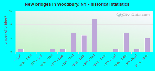
- New bridges - historical statistics
- 1Before 1900
- 11920-1929
- 11930-1939
- 71940-1949
- 61950-1959
- 121960-1969
- 11980-1989
- 71990-1999
- 12000-2009
- 52010-2019
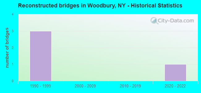
- Reconstructed bridges - Historical Statistics
- 31990-1999
- 02000-2009
- 02010-2019
- 12020-2022
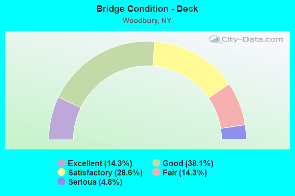
- Bridge Condition - Deck
- 14.3%Excellent
- 38.1%Good
- 28.6%Satisfactory
- 14.3%Fair
- 4.8%Serious
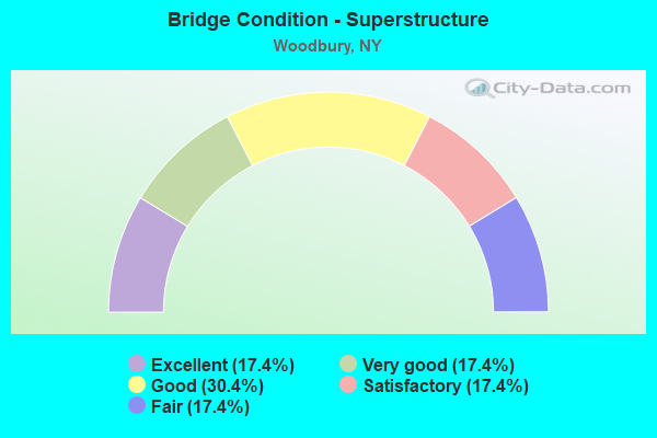
- Bridge Condition - Superstructure
- 17.4%Excellent
- 17.4%Very good
- 30.4%Good
- 17.4%Satisfactory
- 17.4%Fair
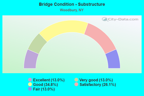
- Bridge Condition - Substructure
- 13.0%Excellent
- 13.0%Very good
- 34.8%Good
- 26.1%Satisfactory
- 13.0%Fair
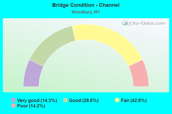
- Bridge Condition - Channel
- 14.3%Very good
- 28.6%Good
- 42.9%Fair
- 14.3%Poor
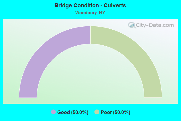
- Bridge Condition - Culverts
- 50.0%Good
- 50.0%Poor
Find on map >> Show street view
Structure Number: 1003341, Location: JCT of Routes 17 & 32 (Lat: 41.316494, Lng: -74.133158), Route carried "on" structure: State highway 32, Year Built: 2019, Status: Open, Structure Length: 4.69m (15.39ft), Average Daily Traffic: 8,271 (year 2016), Truck Traffic: 4%, Average Future Daily Traffic: 10,047 (year 2040), Design Load: HL 93, Features Intersected: 984C 984C83011000 EB, 98
Minimum Vertical Clearance: 32.69m (107.25ft), Kilometerpoint: 0.016, Lanes on structure: 4, Lanes under structure: 8, Owner: State Highway Agency, Approaching Roadway Width: 17.7m (58.1ft), Skew: 2 degrees, Material/Design: Steel, Design/Construction: Stringer/Multi-beam, Number Of Spans In Main Unit: 2, Length of Maximum Span: 23.2m (76.1ft), Curb-To-Curb Width: 17.8m (58.4ft), Out-to-Out Width: 18.7m (61.4ft)
Condition: Deck: Excellent, Superstructure: Excellent, Substructure: Excellent, Operating Rating: 99.8 metric tons, Method Used To Determine Operating Rating: Load Factor (LF), Inventory Rating: 59.0 metric tons, Method Used To Determine Inventory Rating: Load Factor (LF), Structural Evaluation: Superior to present desirable criteria, Deck Geometry: Somewhat better than minimum adequacy, Underclear: Equal to present minimum criteria, Approach Roadway Alignment: Equal to present desirable criteria, Length Of Structure Improvement: 4.69m (15.39ft), Designated Inspection Frequency: Every 24 months, Inspection Date: September 2021, Bridge Improvement Cost: $3,353,000, Roadway Improvement Cost: $1,964,000, Total Project Cost: $5,317,000 ( Estimate for 2021), Deck Structure Type: Concrete Cast-file-Place, Wearing Surface/Protective System: Wearing Surface: Integral Concrete, Deck Protection: Other Coated Reinforcing
Find on map >> Show street view
Structure Number: 1003342, Location: JCT of 17 & 32 (Lat: 41.316589, Lng: -74.133383), Route carried "on" structure: State highway 32, Year Built: 2019, Status: Open, Structure Length: 4.69m (15.39ft), Average Daily Traffic: 8,271 (year 2016), Truck Traffic: 4%, Average Future Daily Traffic: 10,047 (year 2040), Design Load: HL 93, Features Intersected: 984C 984C83011000 EB, 98
Minimum Vertical Clearance: 32.69m (107.25ft), Kilometerpoint: 0.000, Lanes on structure: 3, Lanes under structure: 8, Owner: State Highway Agency, Approaching Roadway Width: 18.0m (59.1ft), Skew: 2 degrees, Material/Design: Steel, Design/Construction: Stringer/Multi-beam, Number Of Spans In Main Unit: 2, Length of Maximum Span: 23.2m (76.1ft), Curb or Sidewalk Widths: Left: 2.4m (7.9ft), Right: 0.0m, Curb-To-Curb Width: 14.0m (45.9ft), Out-to-Out Width: 17.9m (58.7ft)
Condition: Deck: Excellent, Superstructure: Excellent, Substructure: Excellent, Inventory Rating: 61.7 metric tons, Method Used To Determine Inventory Rating: Load Factor (LF), Structural Evaluation: Superior to present desirable criteria, Deck Geometry: Somewhat better than minimum adequacy, Underclear: Somewhat better than minimum adequacy, Approach Roadway Alignment: Equal to present desirable criteria, Length Of Structure Improvement: 4.69m (15.39ft), Designated Inspection Frequency: Every 24 months, Inspection Date: September 2021, Bridge Improvement Cost: $3,171,000, Roadway Improvement Cost: $1,857,000, Total Project Cost: $5,028,000 ( Estimate for 2021), Deck Structure Type: Concrete Cast-file-Place, Wearing Surface/Protective System: Wearing Surface: Integral Concrete, Deck Protection: Other Coated Reinforcing
Find on map >> Show street view
Structure Number: 102223, Location: 2.5 MI N JCT SH32 & SH208 (Lat: 41.374164, Lng: -74.100733), Route carried "on" structure: State highway 32, Year Built: 1934, Status: Open, Structure Length: 1.10m (3.61ft), Average Daily Traffic: 8,451 (year 2020), Truck Traffic: 7%, Average Future Daily Traffic: 10,266 (year 2040), Design Load: H 20, Features Intersected: TRIB WOODBURY CRK
Minimum Vertical Clearance: 30+ m (98+ ft), Kilometerpoint: 7.965, Lanes on structure: 2, Base Highway Network: Yes, Owner: State Highway Agency, Approaching Roadway Width: 11.0m (36.1ft), Material/Design: Concrete continuous, Design/Construction: Culvert, Number Of Spans In Main Unit: 3, Length of Maximum Span: 3.0m (9.8ft)
Condition: Channel: Fair, Culverts: Poor, Operating Rating: 94.3 metric tons, Method Used To Determine Operating Rating: Load Factor (LF), Inventory Rating: 56.2 metric tons, Method Used To Determine Inventory Rating: Load Factor (LF), Structural Evaluation: Meets minimum limits, Waterway Adequacy: Meets minimum limits, Approach Roadway Alignment: Meets minimum limits, Length Of Structure Improvement: 1.09m (3.58ft), Designated Inspection Frequency: Every 24 months, Inspection Date: August 2021, Bridge Improvement Cost: $339,000, Roadway Improvement Cost: $199,000, Total Project Cost: $538,000 ( Estimate for 2021)
Find on map >> Show street view
Structure Number: 1037939, Location: JCT RTE 135+NSP (Lat: 40.794978, Lng: -73.487311), Route carried "on" structure: State highway 135, Year Built: 1962, Status: Open, Structure Length: 3.26m (10.70ft), Average Daily Traffic: 80,261 (year 2019), Truck Traffic: 7%, Average Future Daily Traffic: 95,470 (year 2040), Design Load: H 20, Features Intersected: 908G908G03011145, W/B, R
Minimum Vertical Clearance: 30+ m (98+ ft), Kilometerpoint: 15.012, Lanes on structure: 8, Lanes under structure: 6, Base Highway Network: Yes, Owner: State Highway Agency, Approaching Roadway Width: 33.8m (110.9ft), Skew: 21 degrees, Material/Design: Concrete continuous, Design/Construction: Frame, Number Of Spans In Main Unit: 2, Length of Maximum Span: 16.2m (53.1ft), Curb-To-Curb Width: 33.8m (110.9ft), Out-to-Out Width: 36.3m (119.1ft)
Condition: Deck: Satisfactory, Superstructure: Good, Substructure: Good, Operating Rating: 78.9 metric tons, Method Used To Determine Operating Rating: Load Factor (LF), Inventory Rating: 39.0 metric tons, Method Used To Determine Inventory Rating: Load Factor (LF), Structural Evaluation: Better than present minimum criteria, Deck Geometry: Meets minimum limits, Underclear: High priority of corrective action, Approach Roadway Alignment: Equal to present desirable criteria, Length Of Structure Improvement: 3.26m (10.70ft), Designated Inspection Frequency: Every 24 months, Inspection Date: September 2021, Bridge Improvement Cost: $6,950,000, Roadway Improvement Cost: $4,070,000, Total Project Cost: $11,020,000 ( Estimate for 2021), Wearing Surface/Protective System: Wearing Surface: Bituminous, Membrane: Preformed Fabric
Find on map >> Show street view
Structure Number: 1049229, Location: .2 MI E OF RTE 135+RT 495 (Lat: 40.799369, Lng: -73.484417), Route carried "on" structure: Interstate 495, Year Built: 1963, Status: Open, Structure Length: 3.44m (11.29ft), Average Daily Traffic: 167,874 (year 2020), Truck Traffic: 12%, Average Future Daily Traffic: 176,267 (year 2040), Design Load: HS 20, Features Intersected: WOODBURY ROAD
Minimum Vertical Clearance: 30+ m (98+ ft), Kilometerpoint: 21.545, Lanes on structure: 11, Lanes under structure: 4, Base Highway Network: Yes, Owner: State Highway Agency, Approaching Roadway Width: 50.0m (164.0ft), Skew: 23 degrees, Material/Design: Steel, Design/Construction: Stringer/Multi-beam, Number Of Spans In Main Unit: 1, Length of Maximum Span: 32.6m (107.0ft), Curb-To-Curb Width: 50.0m (164.0ft), Out-to-Out Width: 51.9m (170.3ft)
Condition: Deck: Good, Superstructure: Satisfactory, Substructure: Satisfactory, Operating Rating: 79.8 metric tons, Method Used To Determine Operating Rating: Load Factor (LF), Inventory Rating: 48.1 metric tons, Method Used To Determine Inventory Rating: Load Factor (LF), Structural Evaluation: Equal to present minimum criteria, Deck Geometry: Superior to present desirable criteria, Underclear: Meets minimum limits, Approach Roadway Alignment: Better than present minimum criteria, Length Of Structure Improvement: 3.44m (11.29ft), Designated Inspection Frequency: Every 24 months, Inspection Date: June 2020, Bridge Improvement Cost: $12,279,000, Roadway Improvement Cost: $7,190,000, Total Project Cost: $19,469,000 ( Estimate for 2021), Deck Structure Type: Concrete Cast-file-Place, Wearing Surface/Protective System: Wearing Surface: Monolithic Concrete
Find on map >> Show street view
Structure Number: 1049239, Location: .4 MI E JCT SH135 & I495 (Lat: 40.798914, Lng: -73.482225), Route carried "on" structure: Interstate 495, Year Built: 1963, Status: Open, Structure Length: 2.74m (8.99ft), Average Daily Traffic: 163,304 (year 2020), Truck Traffic: 12%, Average Future Daily Traffic: 171,469 (year 2040), Design Load: HS 20, Features Intersected: MANETTO HILL ROAD
Minimum Vertical Clearance: 30+ m (98+ ft), Kilometerpoint: 21.754, Lanes on structure: 11, Lanes under structure: 4, Base Highway Network: Yes, Owner: State Highway Agency, Approaching Roadway Width: 50.0m (164.0ft), Skew: 23 degrees, Material/Design: Steel, Design/Construction: Stringer/Multi-beam, Number Of Spans In Main Unit: 1, Length of Maximum Span: 25.6m (84.0ft), Curb-To-Curb Width: 50.1m (164.4ft), Out-to-Out Width: 52.0m (170.6ft)
Condition: Deck: Good, Superstructure: Good, Substructure: Good, Operating Rating: 67.1 metric tons, Method Used To Determine Operating Rating: Load Factor (LF), Inventory Rating: 34.5 metric tons, Method Used To Determine Inventory Rating: Load Factor (LF), Structural Evaluation: Better than present minimum criteria, Deck Geometry: Superior to present desirable criteria, Underclear: Meets minimum limits, Approach Roadway Alignment: Better than present minimum criteria, Length Of Structure Improvement: 2.74m (8.99ft), Designated Inspection Frequency: Every 24 months, Inspection Date: August 2020, Bridge Improvement Cost: $10,679,000, Roadway Improvement Cost: $6,254,000, Total Project Cost: $16,933,000 ( Estimate for 2021), Deck Structure Type: Concrete Cast-file-Place, Wearing Surface/Protective System: Wearing Surface: Monolithic Concrete
Find on map >> Show street view
Structure Number: 1049249, Location: JCT NSP & RTE I495 (Lat: 40.797747, Lng: -73.475644), Route carried "on" structure: Interstate 495, Year Built: 1997, Status: Open, Structure Length: 5.91m (19.39ft), Average Daily Traffic: 163,304 (year 2020), Truck Traffic: 13%, Average Future Daily Traffic: 171,469 (year 2040), Design Load: HS 25 or greater, Features Intersected: 908G 908G 0301 1152 EB,
Minimum Vertical Clearance: 30+ m (98+ ft), Kilometerpoint: 22.301, Lanes on structure: 11, Lanes under structure: 4, Base Highway Network: Yes, Owner: State Highway Agency, Approaching Roadway Width: 57.6m (189.0ft), Skew: 24 degrees, Material/Design: Steel continuous, Design/Construction: Stringer/Multi-beam, Number Of Spans In Main Unit: 2, Length of Maximum Span: 28.6m (93.8ft), Curb-To-Curb Width: 57.7m (189.3ft), Out-to-Out Width: 59.8m (196.2ft)
Condition: Deck: Satisfactory, Superstructure: Good, Substructure: Very good, Operating Rating: 89.8 metric tons, Method Used To Determine Operating Rating: Load Factor (LF), Inventory Rating: 43.5 metric tons, Method Used To Determine Inventory Rating: Load Factor (LF), Structural Evaluation: Better than present minimum criteria, Deck Geometry: Superior to present desirable criteria, Underclear: High priority of corrective action, Approach Roadway Alignment: Equal to present desirable criteria, Length Of Structure Improvement: 5.91m (19.39ft), Designated Inspection Frequency: Every 24 months, Inspection Date: September 2021, Bridge Improvement Cost: $20,501,000, Roadway Improvement Cost: $12,005,000, Total Project Cost: $32,506,000 ( Estimate for 2021), Deck Structure Type: Concrete Cast-file-Place, Wearing Surface/Protective System: Wearing Surface: Integral Concrete, Deck Protection: Epoxy Coated Reinforcing
Find on map >> Show street view
Structure Number: 105322, Location: IN HARRIMAN (Lat: 41.307200, Lng: -74.128128), Route carried "on" structure: US 6, Year Built: 1968, Status: Open, Structure Length: 13.90m (45.60ft), Average Daily Traffic: 22,464 (year 2015), Truck Traffic: 2%, Average Future Daily Traffic: 22,569 (year 2040), Design Load: HS 20+Mod, Features Intersected: 87IX SB, RTE I87, RAMAP
Minimum Vertical Clearance: 30+ m (98+ ft), Kilometerpoint: 58.922, Lanes on structure: 3, Lanes under structure: 10, Base Highway Network: Yes, Owner: State Highway Agency, Approaching Roadway Width: 15.5m (50.9ft), Skew: 21 degrees, Material/Design: Steel continuous, Design/Construction: Stringer/Multi-beam, Number Of Spans In Main Unit: 4, Length of Maximum Span: 34.7m (113.8ft), Curb-To-Curb Width: 15.5m (50.9ft), Out-to-Out Width: 17.1m (56.1ft)
Condition: Deck: Good, Superstructure: Very good, Substructure: Satisfactory, Channel: Very good, Operating Rating: 28.2 metric tons, Method Used To Determine Operating Rating: Load and Resistance Factor Rating (LRFR) rating reported by rating factor(RF) method using HL-93 loadings, Inventory Rating: 21.7 metric tons, Method Used To Determine Inventory Rating: Load and Resistance Factor Rating (LRFR) rating reported by rating factor(RF) method using HL-93 loadings, Structural Evaluation: Somewhat better than minimum adequacy, Deck Geometry: Equal to present minimum criteria, Underclear: High priority of corrective action, Waterway Adequacy: Equal to present desirable criteria, Approach Roadway Alignment: Equal to present desirable criteria, Length Of Structure Improvement: 13.89m (45.57ft), Designated Inspection Frequency: Every 24 months, Inspection Date: August 2021, Bridge Improvement Cost: $9,500,000, Roadway Improvement Cost: $5,563,000, Total Project Cost: $15,063,000 ( Estimate for 2021), Deck Structure Type: Concrete Cast-file-Place, Wearing Surface/Protective System: Wearing Surface: Integral Concrete, Deck Protection: Epoxy Coated Reinforcing
Find on map >> Show street view
Structure Number: 105827, Location: .4 MI E JCT RTE 135+ NSP (Lat: 40.795606, Lng: -73.479872), Route carried "on" structure: County highway , Year Built: 1947, Status: Open, Structure Length: 2.44m (8.01ft), Average Daily Traffic: 11,710 (year 2019), Truck Traffic: 2%, Average Future Daily Traffic: 14,225 (year 2040), Design Load: H 20, Features Intersected: 908G908G03011149, RTE 90, Facility Carried by Structure: MANETTO HILL ROAD
Minimum Vertical Clearance: 30+ m (98+ ft), Kilometerpoint: 2.542, Lanes on structure: 2, Lanes under structure: 4, Owner: State Highway Agency, Approaching Roadway Width: 9.8m (32.2ft), Material/Design: Concrete, Design/Construction: Arch - Deck, Number Of Spans In Main Unit: 1, Length of Maximum Span: 22.5m (73.8ft), Curb or Sidewalk Widths: Left: 1.3m (4.3ft), Right: 1.3m (4.3ft), Curb-To-Curb Width: 9.8m (32.2ft), Out-to-Out Width: 13.7m (44.9ft)
Condition: Superstructure: Very good, Substructure: Very good, Operating Rating: 61.8 metric tons, Method Used To Determine Operating Rating: Field evaluation and documented engineering judgment, Inventory Rating: 23.8 metric tons, Method Used To Determine Inventory Rating: Field evaluation and documented engineering judgment, Structural Evaluation: Somewhat better than minimum adequacy, Deck Geometry: Meets minimum limits, Underclear: High priority of corrective action, Approach Roadway Alignment: Equal to present desirable criteria, Length Of Structure Improvement: 2.43m (7.97ft), Designated Inspection Frequency: Every 24 months, Inspection Date: March 2020, Bridge Improvement Cost: $2,703,000, Roadway Improvement Cost: $1,583,000, Total Project Cost: $4,286,000 ( Estimate for 2021), Wearing Surface/Protective System: Wearing Surface: Bituminous, Membrane: Preformed Fabric
Find on map >> Show street view
Structure Number: 105828, Location: .4 MI E JCT RTE 495+ NSP (Lat: 40.798869, Lng: -73.468069), Route carried "on" structure: County highway , Year Built: 1947, Status: Open, Structure Length: 2.47m (8.10ft), Average Daily Traffic: 9,090 (year 2017), Truck Traffic: 2%, Average Future Daily Traffic: 11,042 (year 2040), Design Load: H 20, Features Intersected: 908G908G03011156, RTE 90, Facility Carried by Structure: SUNNYSIDE BLVD
Minimum Vertical Clearance: 30+ m (98+ ft), Kilometerpoint: 1.223, Lanes on structure: 2, Lanes under structure: 4, Owner: State Highway Agency, Approaching Roadway Width: 9.8m (32.2ft), Skew: 1 degrees, Material/Design: Concrete, Design/Construction: Arch - Deck, Number Of Spans In Main Unit: 1, Length of Maximum Span: 22.8m (74.8ft), Curb or Sidewalk Widths: Left: 3.0m (9.8ft), Right: 1.5m (4.9ft), Curb-To-Curb Width: 9.8m (32.2ft), Out-to-Out Width: 13.7m (44.9ft)
Condition: Superstructure: Very good, Substructure: Very good, Operating Rating: 62.1 metric tons, Method Used To Determine Operating Rating: Field evaluation and documented engineering judgment, Inventory Rating: 23.9 metric tons, Method Used To Determine Inventory Rating: Field evaluation and documented engineering judgment, Structural Evaluation: Somewhat better than minimum adequacy, Deck Geometry: Meets minimum limits, Underclear: High priority of corrective action, Approach Roadway Alignment: Equal to present desirable criteria, Length Of Structure Improvement: 2.46m (8.07ft), Designated Inspection Frequency: Every 24 months, Inspection Date: March 2020, Bridge Improvement Cost: $2,624,000, Roadway Improvement Cost: $1,536,000, Total Project Cost: $4,160,000 ( Estimate for 2021), Wearing Surface/Protective System: Wearing Surface: Bituminous, Membrane: Preformed Fabric
Find on map >> Show street view
Structure Number: 1058299, Location: 1.4 MI E JCT RTE 495+NSP (Lat: 40.805150, Lng: -73.449828), Route carried "on" structure: State highway 908G, Year Built: 1947, Status: Open, Structure Length: 1.46m (4.79ft), Average Daily Traffic: 57,817 (year 2020), Average Future Daily Traffic: 68,773 (year 2040), Design Load: H 20, Features Intersected: PLAINVIEW ROAD
Minimum Vertical Clearance: 30+ m (98+ ft), Kilometerpoint: 26.838, Lanes on structure: 4, Lanes under structure: 2, Base Highway Network: Yes, Owner: State Highway Agency, Approaching Roadway Width: 18.6m (61.0ft), Skew: 20 degrees, Material/Design: Concrete, Design/Construction: Frame, Number Of Spans In Main Unit: 1, Length of Maximum Span: 12.8m (42.0ft), Curb-To-Curb Width: 18.7m (61.4ft), Out-to-Out Width: 21.7m (71.2ft)
Condition: Deck: Fair, Superstructure: Fair, Substructure: Satisfactory, Operating Rating: 58.5 metric tons, Method Used To Determine Operating Rating: Field evaluation and documented engineering judgment, Inventory Rating: 22.1 metric tons, Method Used To Determine Inventory Rating: Field evaluation and documented engineering judgment, Structural Evaluation: Somewhat better than minimum adequacy, Deck Geometry: Meets minimum limits, Underclear: Meets minimum limits, Approach Roadway Alignment: Better than present minimum criteria, Length Of Structure Improvement: 1.46m (4.79ft), Designated Inspection Frequency: Every 24 months, Inspection Date: January 2020, Bridge Improvement Cost: $2,054,000, Roadway Improvement Cost: $1,203,000, Total Project Cost: $3,257,000 ( Estimate for 2021), Wearing Surface/Protective System: Wearing Surface: Bituminous, Membrane: Preformed Fabric
Find on map >> Show street view
Structure Number: 1060852, Location: JCT RTE 135+RTE 25 (Lat: 40.811750, Lng: -73.491328), Route carried "on" structure: State highway 25, Year Built: 1962, Status: Open, Structure Length: 4.18m (13.71ft), Average Daily Traffic: 17,061 (year 2020), Truck Traffic: 4%, Average Future Daily Traffic: 19,685 (year 2040), Design Load: H 20, Features Intersected: 135 135 03011116, N/B, R
Minimum Vertical Clearance: 30+ m (98+ ft), Kilometerpoint: 22.365, Lanes on structure: 3, Lanes under structure: 6, Base Highway Network: Yes, Owner: State Highway Agency, Approaching Roadway Width: 14.9m (48.9ft), Skew: 1 degrees, Material/Design: Steel, Design/Construction: Stringer/Multi-beam, Number Of Spans In Main Unit: 2, Length of Maximum Span: 20.1m (65.9ft), Curb or Sidewalk Widths: Left: 0.6m (2.0ft), Right: 1.8m (5.9ft), Curb-To-Curb Width: 14.9m (48.9ft), Out-to-Out Width: 17.8m (58.4ft)
Condition: Deck: Good, Superstructure: Good, Substructure: Good, Operating Rating: 88.9 metric tons, Method Used To Determine Operating Rating: Load Factor (LF), Inventory Rating: 53.5 metric tons, Method Used To Determine Inventory Rating: Load Factor (LF), Structural Evaluation: Better than present minimum criteria, Deck Geometry: Equal to present minimum criteria, Underclear: High priority of corrective action, Approach Roadway Alignment: Equal to present desirable criteria, Length Of Structure Improvement: 4.17m (13.68ft), Designated Inspection Frequency: Every 24 months, Inspection Date: June 2021, Bridge Improvement Cost: $4,174,000, Roadway Improvement Cost: $2,444,000, Total Project Cost: $6,618,000 ( Estimate for 2021), Deck Structure Type: Concrete Cast-file-Place, Wearing Surface/Protective System: Wearing Surface: Bituminous
Find on map >> Show street view
Structure Number: 106878, Location: 0.6 MI S JCT PIP+RTE6 (Lat: 41.298686, Lng: -74.030333), Route carried "on" structure: Ramp Other road , Year Built: 1953, Status: Open, Structure Length: 4.36m (14.30ft), Average Daily Traffic: 178 (year 2020), Average Future Daily Traffic: 427 (year 2040), Design Load: HS 20, Features Intersected: 987C987C83021004 SB, RTE, Facility Carried by Structure: ANTHONY WAYNE DR
Minimum Vertical Clearance: 30+ m (98+ ft), Kilometerpoint: 0.338, Lanes on structure: 2, Lanes under structure: 6, Owner: State Park, Forest, or Reservation Agency, Maintenance Responsibility: State Highway Agency, Approaching Roadway Width: 11.0m (36.1ft), Skew: 3 degrees, Material/Design: Concrete continuous, Design/Construction: Frame, Number Of Spans In Main Unit: 2, Length of Maximum Span: 19.5m (64.0ft), Curb or Sidewalk Widths: Left: 1.5m (4.9ft), Right: 1.5m (4.9ft), Curb-To-Curb Width: 10.4m (34.1ft), Out-to-Out Width: 14.5m (47.6ft)
Condition: Deck: Satisfactory, Superstructure: Satisfactory, Substructure: Fair, Operating Rating: 86.5 metric tons, Method Used To Determine Operating Rating: Field evaluation and documented engineering judgment, Inventory Rating: 32.7 metric tons, Method Used To Determine Inventory Rating: Field evaluation and documented engineering judgment, Structural Evaluation: Somewhat better than minimum adequacy, Deck Geometry: Better than present minimum criteria, Underclear: Meets minimum limits, Approach Roadway Alignment: Meets minimum limits, Length Of Structure Improvement: 4.35m (14.27ft), Designated Inspection Frequency: Every 24 months, Inspection Date: August 2021, Bridge Improvement Cost: $3,418,000, Roadway Improvement Cost: $2,001,000, Total Project Cost: $5,419,000 ( Estimate for 2021)
Find on map >> Show street view
Structure Number: 106883, Location: 0.5 MI E JCT RTS 6 & 293 (Lat: 41.323161, Lng: -74.076464), Route carried "on" structure: US 6, Year Built: 1999, Status: Open, Structure Length: 1.34m (4.40ft), Average Daily Traffic: 24,565 (year 2018), Truck Traffic: 1%, Average Future Daily Traffic: 24,798 (year 2040), Design Load: HS 25 or greater, Features Intersected: LAKE TEATA SPILLWAY
Minimum Vertical Clearance: 30+ m (98+ ft), Kilometerpoint: 63.909, Lanes on structure: 2, Base Highway Network: Yes, Owner: State Park, Forest, or Reservation Agency, Maintenance Responsibility: State Highway Agency, Approaching Roadway Width: 13.7m (44.9ft), Material/Design: Prestressed concrete, Design/Construction: Box Beam or Girders - Multiple, Number Of Spans In Main Unit: 1, Length of Maximum Span: 12.4m (40.7ft), Curb-To-Curb Width: 14.0m (45.9ft), Out-to-Out Width: 14.6m (47.9ft)
Condition: Deck: Good, Superstructure: Satisfactory, Substructure: Good, Channel: Good, Operating Rating: 89.8 metric tons, Method Used To Determine Operating Rating: Load Factor (LF), Inventory Rating: 47.2 metric tons, Method Used To Determine Inventory Rating: Load Factor (LF), Structural Evaluation: Equal to present minimum criteria, Deck Geometry: Superior to present desirable criteria, Waterway Adequacy: Somewhat better than minimum adequacy, Approach Roadway Alignment: Equal to present desirable criteria, Length Of Structure Improvement: 1.34m (4.40ft), Designated Inspection Frequency: Every 24 months, Inspection Date: May 2021, Bridge Improvement Cost: $1,340,000, Roadway Improvement Cost: $784,000, Total Project Cost: $2,124,000 ( Estimate for 2021), Deck Structure Type: Concrete Cast-file-Place, Wearing Surface/Protective System: Wearing Surface: Integral Concrete
Find on map >> Show street view
Structure Number: 107709, Location: .6 MI W JCT RTS 6 & 87 (Lat: 41.314003, Lng: -74.137100), Route carried "on" structure: US 6, Year Built: 1994, Status: Open, Structure Length: 5.70m (18.70ft), Average Daily Traffic: 17,621 (year 2018), Truck Traffic: 2%, Average Future Daily Traffic: 17,703 (year 2040), Design Load: HS 20+Mod, Features Intersected: RTE 17
Minimum Vertical Clearance: 32.69m (107.25ft), Kilometerpoint: 57.924, Lanes on structure: 2, Lanes under structure: 8, Base Highway Network: Yes, Owner: State Highway Agency, Approaching Roadway Width: 13.4m (44.0ft), Material/Design: Steel, Design/Construction: Stringer/Multi-beam, Number Of Spans In Main Unit: 1, Length of Maximum Span: 55.4m (181.8ft), Curb-To-Curb Width: 13.4m (44.0ft), Out-to-Out Width: 14.6m (47.9ft)
Condition: Deck: Good, Superstructure: Good, Substructure: Satisfactory, Operating Rating: 96.2 metric tons, Method Used To Determine Operating Rating: Allowable Stress (AS), Inventory Rating: 40.8 metric tons, Method Used To Determine Inventory Rating: Allowable Stress (AS), Structural Evaluation: Equal to present minimum criteria, Deck Geometry: Equal to present minimum criteria, Underclear: Equal to present minimum criteria, Approach Roadway Alignment: Equal to present desirable criteria, Length Of Structure Improvement: 5.69m (18.67ft), Designated Inspection Frequency: Every 24 months, Inspection Date: April 2021, Bridge Improvement Cost: $3,998,000, Roadway Improvement Cost: $2,341,000, Total Project Cost: $6,338,000 ( Estimate for 2021), Deck Structure Type: Concrete Cast-file-Place, Wearing Surface/Protective System: Wearing Surface: Integral Concrete, Deck Protection: Epoxy Coated Reinforcing
Find on map >> Show street view
Structure Number: 10771, Location: 1.0 MI W JCT RTS 6 & 87 (Lat: 41.318742, Lng: -74.143044), Route carried "on" structure: Ramp US 6, Year Built: 1994, Year Reconstructed: 2020, Status: Open, Structure Length: 14.20m (46.59ft), Average Daily Traffic: 17,621 (year 2018), Truck Traffic: 2%, Average Future Daily Traffic: 24,857 (year 2040), Design Load: HS 20+Mod, Features Intersected: 17 17 83011252 EB, RTE
Minimum Vertical Clearance: 32.69m (107.25ft), Kilometerpoint: 57.184, Lanes on structure: 1, Lanes under structure: 4, Base Highway Network: Yes, Owner: State Highway Agency, Approaching Roadway Width: 8.8m (28.9ft), Material/Design: Steel continuous, Design/Construction: Stringer/Multi-beam, Number Of Spans In Main Unit: 2, Length of Maximum Span: 74.6m (244.8ft), Curb-To-Curb Width: 8.8m (28.9ft), Out-to-Out Width: 9.6m (31.5ft)
Condition: Deck: Good, Superstructure: Good, Substructure: Good, Inventory Rating: 40.8 metric tons, Method Used To Determine Inventory Rating: Allowable Stress (AS), Structural Evaluation: Better than present minimum criteria, Deck Geometry: Superior to present desirable criteria, Underclear: Somewhat better than minimum adequacy, Approach Roadway Alignment: Better than present minimum criteria, Length Of Structure Improvement: 14.20m (46.59ft), Designated Inspection Frequency: Every 24 months, Inspection Date: March 2021, Bridge Improvement Cost: $5,502,000, Roadway Improvement Cost: $3,222,000, Total Project Cost: $8,724,000 ( Estimate for 2021), Deck Structure Type: Concrete Cast-file-Place, Wearing Surface/Protective System: Wearing Surface: Integral Concrete, Deck Protection: Epoxy Coated Reinforcing
Find on map >> Show street view
Structure Number: 108008, Location: JCT of Routes 17 & 32 (Lat: 41.316900, Lng: -74.132358), Route carried "on" structure: State highway 32, Year Built: 2019, Status: Open, Structure Length: 1.89m (6.20ft), Average Daily Traffic: 16,542 (year 2016), Truck Traffic: 4%, Average Future Daily Traffic: 20,095 (year 2040), Design Load: HL 93, Features Intersected: Nininger Road
Minimum Vertical Clearance: 32.69m (107.25ft), Kilometerpoint: 0.161, Lanes on structure: 9, Lanes under structure: 2, Owner: State Highway Agency, Approaching Roadway Width: 40.8m (133.9ft), Skew: 32 degrees, Material/Design: Steel, Design/Construction: Stringer/Multi-beam, Number Of Spans In Main Unit: 1, Length of Maximum Span: 18.3m (60.0ft), Curb or Sidewalk Widths: Left: 1.5m (4.9ft), Right: 0.0m, Curb-To-Curb Width: 39.0m (128.0ft), Out-to-Out Width: 49.9m (163.7ft)
Condition: Deck: Excellent, Superstructure: Excellent, Substructure: Excellent, Inventory Rating: 64.4 metric tons, Method Used To Determine Inventory Rating: Load Factor (LF), Structural Evaluation: Superior to present desirable criteria, Deck Geometry: Superior to present desirable criteria, Underclear: Meets minimum limits, Approach Roadway Alignment: Equal to present desirable criteria, Length Of Structure Improvement: 1.88m (6.17ft), Designated Inspection Frequency: Every 24 months, Inspection Date: October 2021, Bridge Improvement Cost: $4,027,000, Roadway Improvement Cost: $2,358,000, Total Project Cost: $6,386,000 ( Estimate for 2021), Deck Structure Type: Concrete Cast-file-Place, Wearing Surface/Protective System: Wearing Surface: Integral Concrete, Deck Protection: Other Coated Reinforcing
Find on map >> Show street view
Structure Number: 10915, Location: 0.6 MI N JCT RTS 209+52 (Lat: 41.322558, Lng: -74.085603), Route carried "on" structure: US 6, Year Built: 1965, Year Reconstructed: 1999, Status: Open, Structure Length: 1.83m (6.00ft), Average Daily Traffic: 24,565 (year 2018), Truck Traffic: 1%, Average Future Daily Traffic: 24,798 (year 2040), Design Load: HS 20, Features Intersected: RTE 293
Minimum Vertical Clearance: 30+ m (98+ ft), Kilometerpoint: 63.105, Lanes on structure: 2, Lanes under structure: 2, Base Highway Network: Yes, Owner: State Park, Forest, or Reservation Agency, Maintenance Responsibility: State Highway Agency, Approaching Roadway Width: 11.6m (38.1ft), Skew: 2 degrees, Material/Design: Steel, Design/Construction: Stringer/Multi-beam, Number Of Spans In Main Unit: 1, Length of Maximum Span: 16.7m (54.8ft), Curb-To-Curb Width: 10.4m (34.1ft), Out-to-Out Width: 11.3m (37.1ft)
Condition: Deck: Satisfactory, Superstructure: Satisfactory, Substructure: Satisfactory, Operating Rating: 66.1 metric tons, Method Used To Determine Operating Rating: Load and Resistance Factor Rating (LRFR) rating reported by rating factor(RF) method using HL-93 loadings, Inventory Rating: 50.9 metric tons, Method Used To Determine Inventory Rating: Load and Resistance Factor Rating (LRFR) rating reported by rating factor(RF) method using HL-93 loadings, Structural Evaluation: Equal to present minimum criteria, Deck Geometry: Meets minimum limits, Underclear: Meets minimum limits, Approach Roadway Alignment: Equal to present desirable criteria, Length Of Structure Improvement: 1.82m (5.97ft), Designated Inspection Frequency: Every 24 months, Inspection Date: May 2021, Bridge Improvement Cost: $1,894,000, Roadway Improvement Cost: $1,109,000, Total Project Cost: $3,003,000 ( Estimate for 2021), Deck Structure Type: Concrete Cast-file-Place, Wearing Surface/Protective System: Wearing Surface: Integral Concrete, Deck Protection: Epoxy Coated Reinforcing
Find on map >> Show street view
Structure Number: 33454, Location: 2.5 MI NE OF HIGHL MILLS (Lat: 41.369394, Lng: -74.085975), Route carried "on" structure: County highway , Year Built: 1987, Status: Open, Structure Length: 0.85m (2.79ft), Average Daily Traffic: 1,352 (year 2020), Truck Traffic: 3%, Average Future Daily Traffic: 1,672 (year 2040), Design Load: HS 20+Mod, Features Intersected: MINERAL SPRING BK, Facility Carried by Structure: MINERAL SPRING RD
Minimum Vertical Clearance: 30+ m (98+ ft), Kilometerpoint: 5.197, Lanes on structure: 2, Owner: County Highway Agency, Approaching Roadway Width: 8.8m (28.9ft), Skew: 1 degrees, Material/Design: Prestressed concrete, Design/Construction: Box Beam or Girders - Multiple, Number Of Spans In Main Unit: 1, Length of Maximum Span: 8.2m (26.9ft), Curb-To-Curb Width: 8.7m (28.5ft), Out-to-Out Width: 9.4m (30.8ft)
Condition: Deck: Fair, Superstructure: Fair, Substructure: Fair, Channel: Fair, Inventory Rating: 69.9 metric tons, Method Used To Determine Inventory Rating: Load Factor (LF), Structural Evaluation: Somewhat better than minimum adequacy, Deck Geometry: Somewhat better than minimum adequacy, Waterway Adequacy: Superior to present desirable criteria, Approach Roadway Alignment: Equal to present desirable criteria, Length Of Structure Improvement: 0.85m (2.79ft), Designated Inspection Frequency: Every 24 months, Inspection Date: July 2020, Bridge Improvement Cost: $765,000, Roadway Improvement Cost: $448,000, Total Project Cost: $1,213,000 ( Estimate for 2021), Wearing Surface/Protective System: Wearing Surface: Bituminous, Membrane: Other
Find on map >> Show street view
Structure Number: 551425, Location: AT HARRIMAN INT OF I87 (Lat: 41.311242, Lng: -74.124658), Route carried "on" structure: Ramp Other road , Year Built: 2004, Status: Open, Structure Length: 7.04m (23.10ft), Truck Traffic: 15%, Design Load: HS 25 or greater, Features Intersected: MNCRR, Facility Carried by Structure: EX16 RMP TO I87SB
Minimum Vertical Clearance: 30+ m (98+ ft), Kilometerpoint: 0.386, Lanes on structure: 2, Owner: State Toll Authority, Approaching Roadway Width: 16.8m (55.1ft), Skew: 4 degrees, Material/Design: Steel continuous, Design/Construction: Stringer/Multi-beam, Number Of Spans In Main Unit: 3, Length of Maximum Span: 22.9m (75.1ft), Curb-To-Curb Width: 16.8m (55.1ft), Out-to-Out Width: 17.7m (58.1ft)
Condition: Deck: Good, Superstructure: Excellent, Substructure: Good, Operating Rating: 88.6 metric tons, Method Used To Determine Operating Rating: Field evaluation and documented engineering judgment, Inventory Rating: 40.8 metric tons, Method Used To Determine Inventory Rating: Field evaluation and documented engineering judgment, Structural Evaluation: Better than present minimum criteria, Deck Geometry: Superior to present desirable criteria, Underclear: Superior to present desirable criteria, Approach Roadway Alignment: Equal to present desirable criteria, Length Of Structure Improvement: 7.04m (23.10ft), Designated Inspection Frequency: Every 24 months, Inspection Date: October 2020, Bridge Improvement Cost: $5,068,000, Roadway Improvement Cost: $2,968,000, Total Project Cost: $8,035,000 ( Estimate for 2021), Deck Structure Type: Concrete Cast-file-Place, Wearing Surface/Protective System: Wearing Surface: Integral Concrete, Deck Protection: Galvanized Reinforcing
Find on map >> Show street view
Structure Number: 5514269, Location: 1.2 MI S CENTRAL VALLEY (Lat: 41.310900, Lng: -74.122069), Route carried "on" structure: Ramp Other road , Year Built: 1953, Year Reconstructed: 1995, Status: Open, Structure Length: 6.98m (22.90ft), Average Daily Traffic: 2,205 (year 2020), Truck Traffic: 15%, Average Future Daily Traffic: 3,733 (year 2040), Design Load: HS 20+Mod, Features Intersected: 87I - southbound, 87I No, Facility Carried by Structure: ACCESS RAMP EX16N
Minimum Vertical Clearance: 30+ m (98+ ft), Kilometerpoint: 0.563, Lanes on structure: 3, Lanes under structure: 7, Toll: On Interstate toll segment, Owner: State Toll Authority, Approaching Roadway Width: 16.5m (54.1ft), Skew: 20 degrees, Material/Design: Steel, Design/Construction: Stringer/Multi-beam, Number Of Spans In Main Unit: 4, Length of Maximum Span: 21.3m (69.9ft), Curb-To-Curb Width: 15.5m (50.9ft), Out-to-Out Width: 17.1m (56.1ft)
Condition: Deck: Satisfactory, Superstructure: Good, Substructure: Good, Operating Rating: 82.6 metric tons, Method Used To Determine Operating Rating: Load Factor (LF), Inventory Rating: 49.0 metric tons, Method Used To Determine Inventory Rating: Load Factor (LF), Structural Evaluation: Better than present minimum criteria, Deck Geometry: Superior to present desirable criteria, Underclear: High priority of corrective action, Approach Roadway Alignment: Equal to present minimum criteria, Length Of Structure Improvement: 6.97m (22.87ft), Designated Inspection Frequency: Every 24 months, Inspection Date: September 2021, Bridge Improvement Cost: $4,990,000, Roadway Improvement Cost: $2,922,000, Total Project Cost: $7,913,000 ( Estimate for 2021), Deck Structure Type: Concrete Cast-file-Place, Wearing Surface/Protective System: Wearing Surface: Bituminous, Membrane: Other, Deck Protection: Galvanized Reinforcing
Find on map >> Show street view
Structure Number: 5514299, Location: 0.2 MI N JCT RTS I87 & 32 (Lat: 41.374344, Lng: -74.102711), Route carried "on" structure: Interstate 87, Year Built: 1953, Status: Open, Structure Length: 1.28m (4.20ft), Average Daily Traffic: 39,792 (year 2018), Truck Traffic: 19%, Average Future Daily Traffic: 67,383 (year 2040), Design Load: HS 20+Mod, Features Intersected: WOODBURY CREEK
Minimum Vertical Clearance: 30+ m (98+ ft), Kilometerpoint: 23.652, Lanes on structure: 4, Base Highway Network: Yes, Toll: On Interstate toll segment, Owner: State Toll Authority, Approaching Roadway Width: 23.2m (76.1ft), Skew: 30 degrees, Material/Design: Concrete, Design/Construction: Culvert, Number Of Spans In Main Unit: 2, Length of Maximum Span: 6.1m (20.0ft)
Condition: Channel: Good, Culverts: Good, Operating Rating: 89.8 metric tons, Method Used To Determine Operating Rating: Load Factor (LF), Inventory Rating: 64.4 metric tons, Method Used To Determine Inventory Rating: Load Factor (LF), Structural Evaluation: Better than present minimum criteria, Waterway Adequacy: Meets minimum limits, Approach Roadway Alignment: Equal to present desirable criteria, Length Of Structure Improvement: 1.28m (4.20ft), Designated Inspection Frequency: Every 24 months, Inspection Date: June 2021, Bridge Improvement Cost: $1,790,000, Roadway Improvement Cost: $1,048,000, Total Project Cost: $2,838,000 ( Estimate for 2021)
Find on map >> Show street view
Structure Number: 5520049, Location: 1.1 MI S OF CENTRAL VLLEY (Lat: 41.311969, Lng: -74.123917), Route carried "on" structure: Ramp Interstate , Year Built: 1953, Year Reconstructed: 1995, Status: Open, Structure Length: 4.97m (16.31ft), Average Daily Traffic: 2,351 (year 2018), Truck Traffic: 15%, Average Future Daily Traffic: 3,981 (year 2040), Design Load: HS 20+Mod, Features Intersected: METRO NORTH RR, Facility Carried by Structure: 87IX INT 16 RAMP
Minimum Vertical Clearance: 30+ m (98+ ft), Kilometerpoint: 0.740, Lanes on structure: 4, Toll: On Interstate toll segment, Owner: State Toll Authority, Approaching Roadway Width: 25.3m (83.0ft), Skew: 20 degrees, Material/Design: Steel continuous, Design/Construction: Stringer/Multi-beam, Number Of Spans In Main Unit: 3, Length of Maximum Span: 16.5m (54.1ft), Curb-To-Curb Width: 23.9m (78.4ft), Out-to-Out Width: 26.0m (85.3ft)
Condition: Deck: Satisfactory, Superstructure: Very good, Substructure: Good, Operating Rating: 72.6 metric tons, Method Used To Determine Operating Rating: Load Factor (LF), Inventory Rating: 42.6 metric tons, Method Used To Determine Inventory Rating: Load Factor (LF), Structural Evaluation: Better than present minimum criteria, Deck Geometry: Superior to present desirable criteria, Underclear: Equal to present minimum criteria, Approach Roadway Alignment: Equal to present minimum criteria, Length Of Structure Improvement: 4.96m (16.27ft), Designated Inspection Frequency: Every 24 months, Inspection Date: June 2021, Bridge Improvement Cost: $5,192,000, Roadway Improvement Cost: $3,041,000, Total Project Cost: $8,233,000 ( Estimate for 2021), Deck Structure Type: Concrete Cast-file-Place, Wearing Surface/Protective System: Wearing Surface: Bituminous, Membrane: Other, Deck Protection: Galvanized Reinforcing
Find on map >> Show street view
Structure Number: 552142, Location: 2.5 MI SW JCT RTS 6<9W (Lat: 41.303100, Lng: -74.038656), Route carried "on" structure: Other road 987E, Year Built: 1920, Status: Open, Structure Length: 1.62m (5.31ft), Average Daily Traffic: 856 (year 2016), Truck Traffic: 2%, Average Future Daily Traffic: 1,198 (year 2036), Features Intersected: QUEENSBORO BROOK
Minimum Vertical Clearance: 30+ m (98+ ft), Kilometerpoint: 11.392, Lanes on structure: 2, Base Highway Network: Yes, Owner: State Park, Forest, or Reservation Agency, Approaching Roadway Width: 8.8m (28.9ft), Skew: 6 degrees, Material/Design: Concrete continuous, Design/Construction: Frame, Number Of Spans In Main Unit: 2, Length of Maximum Span: 7.9m (25.9ft), Curb-To-Curb Width: 9.8m (32.2ft), Out-to-Out Width: 12.8m (42.0ft)
Condition: Deck: Fair, Superstructure: Fair, Substructure: Fair, Channel: Poor, Operating Rating: 49.3 metric tons, Method Used To Determine Operating Rating: Field evaluation and documented engineering judgment, Inventory Rating: 20.6 metric tons, Method Used To Determine Inventory Rating: Field evaluation and documented engineering judgment, Structural Evaluation: Somewhat better than minimum adequacy, Deck Geometry: Equal to present minimum criteria, Waterway Adequacy: Equal to present desirable criteria, Approach Roadway Alignment: Equal to present desirable criteria, Length Of Structure Improvement: 1.61m (5.28ft), Designated Inspection Frequency: Every 24 months, Inspection Date: May 2020, Bridge Improvement Cost: $1,244,000, Roadway Improvement Cost: $728,000, Total Project Cost: $1,972,000 ( Estimate for 2021)
Find on map >> Show street view
Structure Number: 552144, Location: 4 MI SW JCT US 6 & US 9W (Lat: 41.295058, Lng: -74.059703), Route carried "on" structure: Ramp Other road , Year Built: 1940, Status: Open, Structure Length: 0.88m (2.89ft), Truck Traffic: 8%, Features Intersected: QUEENSBORO BROOK, Facility Carried by Structure: SILVERMINE ROAD
Minimum Vertical Clearance: 30+ m (98+ ft), Kilometerpoint: 0.113, Lanes on structure: 2, Owner: State Park, Forest, or Reservation Agency, Approaching Roadway Width: 5.5m (18.0ft), Material/Design: Steel continuous, Design/Construction: Stringer/Multi-beam, Number Of Spans In Main Unit: 2, Length of Maximum Span: 3.6m (11.8ft), Curb or Sidewalk Widths: Left: 0.4m (1.3ft), Right: 0.3m (1.0ft), Curb-To-Curb Width: 5.2m (17.1ft), Out-to-Out Width: 6.6m (21.7ft)
Condition: Deck: Serious, Superstructure: Fair, Substructure: Satisfactory, Channel: Fair, Operating Rating: 56.2 metric tons, Method Used To Determine Operating Rating: Load Factor (LF), Inventory Rating: 33.6 metric tons, Method Used To Determine Inventory Rating: Load Factor (LF), Structural Evaluation: Somewhat better than minimum adequacy, Deck Geometry: High priority of replacement, Waterway Adequacy: Meets minimum limits, Approach Roadway Alignment: Better than present minimum criteria, Length Of Structure Improvement: 0.88m (2.89ft), Designated Inspection Frequency: Every 24 months, Inspection Date: August 2021, Bridge Improvement Cost: $310,000, Roadway Improvement Cost: $181,000, Total Project Cost: $491,000 ( Estimate for 2021), Deck Structure Type: Concrete Cast-file-Place, Wearing Surface/Protective System: Wearing Surface: Bituminous
Find on map >> Show street view
Structure Number: 1037939, Location: JCT RTE 135+NSP (Lat: 40.794978, Lng: -73.487311), Route carried "under" structure: State highway 908G, Year Built: 1962, Structure Length: 0. m, Average Daily Traffic: 89,805 (year 2002), Features Intersected: 908G908G03011145, W/B, R, Facility Carried by Structure: RTE 135
Minimum Vertical Clearance: 4.37m (14.34ft), Kilometerpoint: 23.443, Lanes on structure: 8, Lanes under structure: 3, Material/Design: Concrete continuous, Design/Construction: Frame, Length of Maximum Span: 16.2m (53.1ft)
Find on map >> Show street view
Structure Number: 1049229, Location: .2 MI E OF RTE 135+RT 495 (Lat: 40.799369, Lng: -73.484417), Route carried "under" structure: Other road , Year Built: 1963, Structure Length: 0. m, Average Daily Traffic: 17,863 (year 2005), Features Intersected: WOODBURY ROAD, Facility Carried by Structure: RTE I495
Minimum Vertical Clearance: 4.65m (15.26ft), Kilometerpoint: 0.000, Lanes on structure: 11, Lanes under structure: 4, Material/Design: Steel, Design/Construction: Stringer/Multi-beam, Length of Maximum Span: 32.6m (107.0ft)
Find on map >> Show street view
Structure Number: 1049239, Location: .4 MI E JCT SH135 & I495 (Lat: 40.798914, Lng: -73.482225), Route carried "under" structure: County highway , Year Built: 1963, Structure Length: 0. m, Average Daily Traffic: 17,074 (year 2002), Features Intersected: MANETTO HILL ROAD, Facility Carried by Structure: RTE I495
Minimum Vertical Clearance: 4.41m (14.47ft), Kilometerpoint: 0.000, Lanes on structure: 11, Lanes under structure: 4, Material/Design: Steel, Design/Construction: Stringer/Multi-beam, Length of Maximum Span: 25.6m (84.0ft)
Find on map >> Show street view
Structure Number: 1049249, Location: JCT NSP & RTE I495 (Lat: 40.797747, Lng: -73.475644), Route carried "under" structure: Other road 908G, Year Built: 1997, Structure Length: 0. m, Average Daily Traffic: 83,069 (year 2002), Features Intersected: 908G 908G 0301 1152 EB,, Facility Carried by Structure: RTE I495
Minimum Vertical Clearance: 4.88m (16.01ft), Kilometerpoint: 24.392, Lanes on structure: 11, Lanes under structure: 2, Material/Design: Steel continuous, Design/Construction: Stringer/Multi-beam, Length of Maximum Span: 28.6m (93.8ft)
Find on map >> Show street view
Structure Number: 105322, Location: IN HARRIMAN (Lat: 41.307200, Lng: -74.128128), Route carried "under" structure: Interstate 87, Year Built: 1968, Structure Length: 0. m, Average Daily Traffic: 43,300 (year 1984), Features Intersected: 87IX SB, RTE I87, RAMAP, Facility Carried by Structure: RTE 6
Minimum Vertical Clearance: 7.06m (23.16ft), Kilometerpoint: 72.067, Lanes on structure: 3, Lanes under structure: 5, Toll: On toll road, Material/Design: Steel continuous, Design/Construction: Stringer/Multi-beam, Length of Maximum Span: 34.7m (113.8ft)
Find on map >> Show street view
Structure Number: 105827, Location: .4 MI E JCT RTE 135+ NSP (Lat: 40.795606, Lng: -73.479872), Route carried "under" structure: State highway 908G, Year Built: 1947, Structure Length: 0. m, Average Daily Traffic: 83,069 (year 2002), Features Intersected: 908G908G03011149, RTE 90, Facility Carried by Structure: MANETTO HILL ROAD
Minimum Vertical Clearance: 4.34m (14.24ft), Kilometerpoint: 24.087, Lanes on structure: 2, Lanes under structure: 2, Material/Design: Concrete, Design/Construction: Arch - Deck, Length of Maximum Span: 22.5m (73.8ft)
Find on map >> Show street view
Structure Number: 105828, Location: .4 MI E JCT RTE 495+ NSP (Lat: 40.798869, Lng: -73.468069), Route carried "under" structure: State highway 908G, Year Built: 1947, Structure Length: 0. m, Average Daily Traffic: 85,227 (year 2002), Features Intersected: 908G908G03011156, RTE 90, Facility Carried by Structure: SUNNYSIDE BLVD
Minimum Vertical Clearance: 4.34m (14.24ft), Kilometerpoint: 25.165, Lanes on structure: 2, Lanes under structure: 2, Material/Design: Concrete, Design/Construction: Arch - Deck, Length of Maximum Span: 22.8m (74.8ft)
Find on map >> Show street view
Structure Number: 1058299, Location: 1.4 MI E JCT RTE 495+NSP (Lat: 40.805150, Lng: -73.449828), Route carried "under" structure: County highway , Year Built: 1947, Structure Length: 0. m, Average Daily Traffic: 3,500 (year 1976), Features Intersected: PLAINVIEW ROAD, Facility Carried by Structure: RTE 908G
Minimum Vertical Clearance: 4.80m (15.75ft), Kilometerpoint: 0.000, Lanes on structure: 4, Lanes under structure: 2, Material/Design: Concrete, Design/Construction: Frame, Length of Maximum Span: 12.8m (42.0ft)
Find on map >> Show street view
Structure Number: 1060852, Location: JCT RTE 135+RTE 25 (Lat: 40.811750, Lng: -73.491328), Route carried "under" structure: State highway 135, Year Built: 1962, Structure Length: 0. m, Average Daily Traffic: 27,200 (year 1973), Features Intersected: 135 135 03011116, N/B, R, Facility Carried by Structure: RTE 25
Minimum Vertical Clearance: 4.67m (15.32ft), Kilometerpoint: 17.329, Lanes on structure: 3, Lanes under structure: 3, Material/Design: Steel, Design/Construction: Stringer/Multi-beam, Length of Maximum Span: 20.1m (65.9ft)
Find on map >> Show street view
Structure Number: 106878, Location: 0.6 MI S JCT PIP+RTE6 (Lat: 41.298686, Lng: -74.030333), Route carried "under" structure: State lands road 987C, Year Built: 1953, Structure Length: 0. m, Average Daily Traffic: 26,358 (year 2002), Features Intersected: 987C987C83021004 SB, RTE, Facility Carried by Structure: ANTHONY WAYNE DR
Minimum Vertical Clearance: 5.86m (19.23ft), Kilometerpoint: 0.644, Lanes on structure: 2, Lanes under structure: 3, Material/Design: Concrete continuous, Design/Construction: Frame, Length of Maximum Span: 19.5m (64.0ft)
Find on map >> Show street view
Structure Number: 107709, Location: .6 MI W JCT RTS 6 & 87 (Lat: 41.314003, Lng: -74.137100), Route carried "under" structure: State highway 17, Year Built: 1994, Structure Length: 0. m, Average Daily Traffic: 19,031 (year 1994), Features Intersected: RTE 17, Facility Carried by Structure: RTE 6
Minimum Vertical Clearance: 5.13m (16.83ft), Kilometerpoint: 99.758, Lanes on structure: 2, Lanes under structure: 8, Material/Design: Steel, Design/Construction: Stringer/Multi-beam, Length of Maximum Span: 55.4m (181.8ft)
Find on map >> Show street view
Structure Number: 10771, Location: 1.0 MI W JCT RTS 6 & 87 (Lat: 41.318742, Lng: -74.143044), Route carried "under" structure: State highway 17, Year Built: 1994, Structure Length: 0. m, Average Daily Traffic: 13,000 (year 1994), Features Intersected: 17 17 83011252 EB, RTE, Facility Carried by Structure: RTE 6
Minimum Vertical Clearance: 5.33m (17.49ft), Kilometerpoint: 612.064, Lanes on structure: 1, Lanes under structure: 2, Material/Design: Steel continuous, Design/Construction: Stringer/Multi-beam, Length of Maximum Span: 74.6m (244.8ft)
Find on map >> Show street view
Structure Number: 10915, Location: 0.6 MI N JCT RTS 209+52 (Lat: 41.322558, Lng: -74.085603), Route carried "under" structure: State highway 293, Year Built: 1965, Structure Length: 0. m, Average Daily Traffic: 2,685 (year 2002), Features Intersected: RTE 293, Facility Carried by Structure: RTE 6
Minimum Vertical Clearance: 5.16m (16.93ft), Kilometerpoint: 0.644, Lanes on structure: 2, Lanes under structure: 2, Material/Design: Steel, Design/Construction: Stringer/Multi-beam, Length of Maximum Span: 16.7m (54.8ft)
Find on map >> Show street view
Structure Number: 551422, Location: 0.2 MI N. OF US-6/I-87 (Lat: 41.309203, Lng: -74.124844), Route carried "under" structure: Interstate 87, Year Built: 2010, Structure Length: 0. m, Average Daily Traffic: 89,528 (year 2014), Truck Traffic: 20%, Features Intersected: I-87 SB, I-87 NB Ramp Fr, Facility Carried by Structure: PEDESTRIAN PATH OV
Minimum Vertical Clearance: 5.87m (19.26ft), Kilometerpoint: 72.453, Lanes under structure: 5, Toll: On Interstate toll segment, Material/Design: Steel, Design/Construction: Truss - Thru, Length of Maximum Span: 36.3m (119.1ft)
Find on map >> Show street view
Structure Number: 551422, Location: 0.2 MI N. OF US-6/I-87 (Lat: 41.309203, Lng: -74.124844), Route carried "under" structure: Interstate , Year Built: 2010, Structure Length: 0. m, Features Intersected: I-87 SB, I-87 NB Ramp Fr, Facility Carried by Structure: PEDESTRIAN PATH OV
Minimum Vertical Clearance: 5.72m (18.77ft), Kilometerpoint: 72.453, Lanes under structure: 1, Toll: On Interstate toll segment, Material/Design: Steel, Design/Construction: Truss - Thru, Length of Maximum Span: 36.3m (119.1ft)
Find on map >> Show street view
Structure Number: 5514269, Location: 1.2 MI S CENTRAL VALLEY (Lat: 41.310900, Lng: -74.122069), Route carried "under" structure: Interstate 87, Year Built: 1953, Structure Length: 0. m, Average Daily Traffic: 11,500 (year 2000), Features Intersected: 87I - southbound, 87I No, Facility Carried by Structure: ACCESS RAMP EX16N
Minimum Vertical Clearance: 5.82m (19.09ft), Kilometerpoint: 72.727, Lanes on structure: 3, Lanes under structure: 2, Toll: On Interstate toll segment, Material/Design: Steel, Design/Construction: Stringer/Multi-beam, Length of Maximum Span: 21.3m (69.9ft)
Find on map >> Show street view
Structure Number: 770952, Location: 2.1 MI EAST OF SYOSSET (Lat: 40.829425, Lng: -73.459461), Route carried "under" structure: County highway , Year Built: 1896, Structure Length: 0. m, Average Daily Traffic: 7,500 (year 1977), Features Intersected: WOODBURY RD, Facility Carried by Structure: LIRR PT JEFF BR
Minimum Vertical Clearance: 4.08m (13.39ft), Kilometerpoint: 0.000, Lanes under structure: 2, Material/Design: Steel, Design/Construction: Stringer/Multi-beam, Length of Maximum Span: 12.8m (42.0ft)