Bridge Statistics for Woodland Mills, Tennessee (TN)
Condition, Traffic, Stress, Structural Evaluation, Project Costs
- National Bridge Inventory (NBI) Statistics
- 17Number of bridges
- 92ft / 27.6mTotal length
- $1,217,000Total costs
- 12,586Total average daily traffic
- 650Total average daily truck traffic
- 19,916Total future (year 2041) average daily traffic
- National Bridge Inventory (NBI) Registered Bridges for Woodland Mills
- No street view available for this location
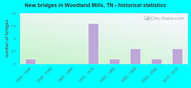
- New bridges - historical statistics
- 11940-1949
- 81970-1979
- 11980-1989
- 31990-1999
- 12000-2009
- 32010-2019

- Reconstructed bridges - Historical Statistics
- 21990-1999
- 42000-2009


- Bridge Condition - Deck
- 12.5%Very good
- 56.3%Good
- 31.3%Satisfactory

- Bridge Condition - Superstructure
- 31.3%Very good
- 25.0%Good
- 37.5%Satisfactory
- 6.3%Fair

- Bridge Condition - Substructure
- 12.5%Very good
- 68.8%Good
- 18.8%Satisfactory

- Bridge Condition - Channel
- 11.8%Good
- 88.2%Satisfactory
Find on map >> Show street view
Structure Number: 66015300001, Location: 4.5 MI SE JCT SR22&SR157 (Lat: 36.403694, Lng: -89.235472), Route carried "on" structure: County highway 5742, Year Built: 1970, Year Reconstructed: 2009, Status: Open, Structure Length: 1.68m (5.51ft), Average Daily Traffic: 590 (year 2020), Truck Traffic: 5%, Average Future Daily Traffic: 944 (year 2041), Design Load: H 15, Features Intersected: KILHAM CREEK, Facility Carried by Structure: NFA 1530 (SA 6613)
Minimum Vertical Clearance: 30+ m (98+ ft), Kilometerpoint: 12.376, Lanes on structure: 2, Owner: County Highway Agency, Approaching Roadway Width: 9.4m (30.8ft), Material/Design: Concrete, Design/Construction: Box Beam or Girders - Multiple, Number Of Spans In Main Unit: 1, Number Of Approach Spans: 1, Length of Maximum Span: 11.0m (36.1ft), Curb-To-Curb Width: 7.3m (24.0ft), Out-to-Out Width: 7.7m (25.3ft)
Condition: Deck: Good, Superstructure: Fair, Substructure: Good, Channel: Satisfactory, Operating Rating: 36.0 metric tons, Method Used To Determine Operating Rating: Field evaluation and documented engineering judgment, Inventory Rating: 24.3 metric tons, Method Used To Determine Inventory Rating: Field evaluation and documented engineering judgment, Structural Evaluation: Somewhat better than minimum adequacy, Deck Geometry: Meets minimum limits, Waterway Adequacy: Equal to present desirable criteria, Approach Roadway Alignment: Equal to present desirable criteria, Length Of Structure Improvement: 1.68m (5.51ft), Designated Inspection Frequency: Every 24 months, Inspection Date: April 2021, Bridge Improvement Cost: $112,000, Roadway Improvement Cost: $12,000, Total Project Cost: $169,000 ( Estimate for 2021), Deck Structure Type: Other, Wearing Surface/Protective System: Wearing Surface: Monolithic Concrete
Find on map >> Show street view
Structure Number: 66015320001, Location: 3.8 MI NW JCT SR5&SR22 (Lat: 36.456444, Lng: -89.149333), Route carried "on" structure: County highway 1532, Year Built: 1986, Status: Open, Structure Length: 1.13m (3.71ft), Average Daily Traffic: 343 (year 2020), Truck Traffic: 3%, Average Future Daily Traffic: 576 (year 2041), Design Load: HS 20, Features Intersected: CANE CREEK
Minimum Vertical Clearance: 30+ m (98+ ft), Kilometerpoint: 2.977, Lanes on structure: 2, Owner: County Highway Agency, Approaching Roadway Width: 8.5m (27.9ft), Skew: 3 degrees, Material/Design: Concrete continuous, Design/Construction: Culvert, Number Of Spans In Main Unit: 2, Length of Maximum Span: 4.6m (15.1ft), Curb-To-Curb Width: 6.8m (22.3ft), Out-to-Out Width: 7.8m (25.6ft)
Condition: Channel: Satisfactory, Culverts: Fair, Operating Rating: 89.1 metric tons, Method Used To Determine Operating Rating: Load Factor (LF), Inventory Rating: 32.4 metric tons, Method Used To Determine Inventory Rating: Load Factor (LF), Structural Evaluation: Somewhat better than minimum adequacy, Deck Geometry: Meets minimum limits, Waterway Adequacy: Equal to present minimum criteria, Approach Roadway Alignment: Equal to present desirable criteria, Designated Inspection Frequency: Every 24 months, Inspection Date: April 2021, Deck Structure Type: Concrete Cast-file-Place, Wearing Surface/Protective System: Wearing Surface: Bituminous
Find on map >> Show street view
Structure Number: 66015320003, Location: 4.6 MI NW JCT SR5&SR22 (Lat: 36.465000, Lng: -89.159139), Route carried "on" structure: County highway 1532, Year Built: 1970, Status: Posted for load, Structure Length: 0.73m (2.40ft), Average Daily Traffic: 343 (year 2020), Truck Traffic: 3%, Average Future Daily Traffic: 549 (year 2041), Design Load: H 15, Features Intersected: CUB BRANCH
Minimum Vertical Clearance: 30+ m (98+ ft), Kilometerpoint: 1.199, Lanes on structure: 2, Owner: County Highway Agency, Approaching Roadway Width: 7.6m (24.9ft), Skew: 3 degrees, Material/Design: Steel, Design/Construction: Stringer/Multi-beam, Number Of Spans In Main Unit: 1, Length of Maximum Span: 7.0m (23.0ft), Curb-To-Curb Width: 6.8m (22.3ft), Out-to-Out Width: 7.3m (24.0ft)
Condition: Deck: Satisfactory, Superstructure: Satisfactory, Substructure: Satisfactory, Channel: Satisfactory, Operating Rating: 31.5 metric tons, Method Used To Determine Operating Rating: Load Factor (LF), Inventory Rating: 18.9 metric tons, Method Used To Determine Inventory Rating: Load Factor (LF), Structural Evaluation: Somewhat better than minimum adequacy, Deck Geometry: Meets minimum limits, Waterway Adequacy: Equal to present minimum criteria, Approach Roadway Alignment: Equal to present desirable criteria, Length Of Structure Improvement: 0.73m (2.40ft), Designated Inspection Frequency: Every 24 months, Inspection Date: April 2021, Bridge Improvement Cost: $56,000, Roadway Improvement Cost: $6,000, Total Project Cost: $85,000 ( Estimate for 2021), Deck Structure Type: Concrete Cast-file-Place, Wearing Surface/Protective System: Wearing Surface: Bituminous
Find on map >> Show street view
Structure Number: 66015340001, Location: 4.9 MI NW JCT SR5&SR22 (Lat: 36.483667, Lng: -89.147556), Route carried "on" structure: County highway 1534, Year Built: 1970, Year Reconstructed: 2002, Status: Posted for load, Structure Length: 0.94m (3.08ft), Average Daily Traffic: 543 (year 2020), Truck Traffic: 4%, Average Future Daily Traffic: 869 (year 2042), Design Load: H 15, Features Intersected: CUB BRANCH
Minimum Vertical Clearance: 30+ m (98+ ft), Kilometerpoint: 4.225, Lanes on structure: 2, Owner: County Highway Agency, Approaching Roadway Width: 8.5m (27.9ft), Material/Design: Concrete, Design/Construction: Channel Beam, Number Of Spans In Main Unit: 1, Length of Maximum Span: 9.1m (29.9ft), Curb-To-Curb Width: 7.1m (23.3ft), Out-to-Out Width: 7.6m (24.9ft)
Condition: Deck: Satisfactory, Superstructure: Satisfactory, Substructure: Good, Channel: Satisfactory, Operating Rating: 32.4 metric tons, Method Used To Determine Operating Rating: Load Factor (LF), Inventory Rating: 19.8 metric tons, Method Used To Determine Inventory Rating: Load Factor (LF), Structural Evaluation: Somewhat better than minimum adequacy, Deck Geometry: Meets minimum limits, Waterway Adequacy: Equal to present minimum criteria, Approach Roadway Alignment: Equal to present desirable criteria, Length Of Structure Improvement: 0.94m (3.08ft), Designated Inspection Frequency: Every 24 months, Inspection Date: April 2021, Bridge Improvement Cost: $74,000, Roadway Improvement Cost: $8,000, Total Project Cost: $112,000 ( Estimate for 2022), Deck Structure Type: Concrete Precast Panels, Wearing Surface/Protective System: Wearing Surface: Bituminous
Find on map >> Show street view
Structure Number: 66015340003, Location: 0.1 MI W OF WOODLAND MILL (Lat: 36.483194, Lng: -89.118472), Route carried "on" structure: County highway 1534, Year Built: 1970, Year Reconstructed: 2006, Status: Posted for load, Structure Length: 0.87m (2.85ft), Average Daily Traffic: 543 (year 2020), Truck Traffic: 4%, Average Future Daily Traffic: 869 (year 2041), Design Load: H 15, Features Intersected: CANE CREEK
Minimum Vertical Clearance: 30+ m (98+ ft), Kilometerpoint: 6.872, Lanes on structure: 2, Owner: County Highway Agency, Approaching Roadway Width: 7.9m (25.9ft), Material/Design: Concrete, Design/Construction: Channel Beam, Number Of Spans In Main Unit: 1, Length of Maximum Span: 8.7m (28.5ft), Curb-To-Curb Width: 7.3m (24.0ft), Out-to-Out Width: 7.6m (24.9ft)
Condition: Deck: Very good, Superstructure: Satisfactory, Substructure: Very good, Channel: Satisfactory, Operating Rating: 32.4 metric tons, Method Used To Determine Operating Rating: Load Factor (LF), Inventory Rating: 18.9 metric tons, Method Used To Determine Inventory Rating: Load Factor (LF), Structural Evaluation: Somewhat better than minimum adequacy, Deck Geometry: Meets minimum limits, Waterway Adequacy: Equal to present minimum criteria, Approach Roadway Alignment: Equal to present desirable criteria, Designated Inspection Frequency: Every 24 months, Inspection Date: April 2021, Deck Structure Type: Concrete Precast Panels, Wearing Surface/Protective System: Wearing Surface: Bituminous
Find on map >> Show street view
Structure Number: 66015340005, Location: 4.2 MI N JCT SR5&SR22 (Lat: 36.488694, Lng: -89.109194), Route carried "on" structure: City street 1534, Year Built: 2004, Status: Posted for load, Structure Length: 1.83m (6.00ft), Average Daily Traffic: 158 (year 2020), Truck Traffic: 3%, Average Future Daily Traffic: 253 (year 2042), Design Load: H 15, Features Intersected: N. REELFOOT CREEK
Minimum Vertical Clearance: 30+ m (98+ ft), Kilometerpoint: 8.351, Lanes on structure: 2, Owner: City or Municipal Highway Agency, Approaching Roadway Width: 8.2m (26.9ft), Material/Design: Prestressed concrete, Design/Construction: Box Beam or Girders - Multiple, Number Of Spans In Main Unit: 1, Length of Maximum Span: 18.3m (60.0ft), Curb-To-Curb Width: 7.3m (24.0ft), Out-to-Out Width: 7.6m (24.9ft)
Condition: Deck: Satisfactory, Superstructure: Satisfactory, Substructure: Good, Channel: Good, Operating Rating: 36.0 metric tons, Method Used To Determine Operating Rating: Field evaluation and documented engineering judgment, Inventory Rating: 24.3 metric tons, Method Used To Determine Inventory Rating: Field evaluation and documented engineering judgment, Structural Evaluation: Equal to present minimum criteria, Deck Geometry: Somewhat better than minimum adequacy, Waterway Adequacy: Equal to present minimum criteria, Approach Roadway Alignment: Equal to present desirable criteria, Length Of Structure Improvement: 1.83m (6.00ft), Designated Inspection Frequency: Every 24 months, Inspection Date: April 2021, Bridge Improvement Cost: $299,000, Roadway Improvement Cost: $30,000, Total Project Cost: $449,000 ( Estimate for 2022), Deck Structure Type: Other, Wearing Surface/Protective System: Wearing Surface: Bituminous
Find on map >> Show street view
Structure Number: 660A0900001, Location: WOODRINE ROAD (Lat: 36.494806, Lng: -89.230889), Route carried "on" structure: County highway 90, Year Built: 1970, Status: Open, Structure Length: 0.87m (2.85ft), Average Daily Traffic: 70 (year 2022), Truck Traffic: 2%, Average Future Daily Traffic: 112 (year 2041), Design Load: H 15, Features Intersected: BRANCH
Minimum Vertical Clearance: 30+ m (98+ ft), Kilometerpoint: 2.449, Lanes on structure: 2, Owner: County Highway Agency, Approaching Roadway Width: 6.7m (22.0ft), Material/Design: Concrete, Design/Construction: Channel Beam, Number Of Spans In Main Unit: 1, Length of Maximum Span: 8.7m (28.5ft), Curb-To-Curb Width: 6.4m (21.0ft), Out-to-Out Width: 6.7m (22.0ft)
Condition: Deck: Good, Superstructure: Satisfactory, Substructure: Satisfactory, Channel: Satisfactory, Operating Rating: 31.5 metric tons, Method Used To Determine Operating Rating: Load Factor (LF), Inventory Rating: 18.9 metric tons, Method Used To Determine Inventory Rating: Load Factor (LF), Structural Evaluation: Somewhat better than minimum adequacy, Deck Geometry: Somewhat better than minimum adequacy, Waterway Adequacy: Better than present minimum criteria, Approach Roadway Alignment: Equal to present desirable criteria, Designated Inspection Frequency: Every 24 months, Inspection Date: April 2021, Deck Structure Type: Concrete Precast Panels, Wearing Surface/Protective System: Wearing Surface: Bituminous
Find on map >> Show street view
Structure Number: 660A0980005, Location: 2.8 MI W JCT SR5&KY LINE (Lat: 36.504806, Lng: -89.170639), Route carried "on" structure: City street 98, Year Built: 1994, Status: Open, Structure Length: 0.91m (2.99ft), Average Daily Traffic: 230 (year 2022), Truck Traffic: 3%, Average Future Daily Traffic: 368 (year 2041), Design Load: HS 20, Features Intersected: BRANCH
Minimum Vertical Clearance: 30+ m (98+ ft), Kilometerpoint: 0.000, Lanes on structure: 2, Owner: City or Municipal Highway Agency, Approaching Roadway Width: 7.3m (24.0ft), Skew: 4 degrees, Material/Design: Prestressed concrete, Design/Construction: Box Beam or Girders - Multiple, Number Of Spans In Main Unit: 1, Length of Maximum Span: 9.1m (29.9ft), Curb-To-Curb Width: 6.9m (22.6ft), Out-to-Out Width: 7.5m (24.6ft)
Condition: Deck: Very good, Superstructure: Very good, Substructure: Good, Channel: Satisfactory, Operating Rating: 44.1 metric tons, Method Used To Determine Operating Rating: Assigned rating based on Load Factor Design (LFD) reported in metric tons, Inventory Rating: 32.4 metric tons, Method Used To Determine Inventory Rating: Assigned rating based on Load Factor Design (LFD) reported in metric tons, Structural Evaluation: Better than present minimum criteria, Deck Geometry: Meets minimum limits, Waterway Adequacy: Equal to present desirable criteria, Approach Roadway Alignment: Equal to present desirable criteria, Designated Inspection Frequency: Every 24 months, Inspection Date: April 2021, Deck Structure Type: Other, Wearing Surface/Protective System: Wearing Surface: Monolithic Concrete, Deck Protection: Epoxy Coated Reinforcing
Find on map >> Show street view
Structure Number: 660A1020001, Location: 1.6 MI SW JCT SR5&KY LINE (Lat: 36.490444, Lng: -89.143806), Route carried "on" structure: County highway 102, Year Built: 1995, Status: Open, Structure Length: 0.88m (2.89ft), Average Daily Traffic: 20 (year 2022), Truck Traffic: 4%, Average Future Daily Traffic: 32 (year 2041), Design Load: H 15, Features Intersected: CUB BRANCH
Minimum Vertical Clearance: 30+ m (98+ ft), Kilometerpoint: 1.431, Lanes on structure: 2, Owner: County Highway Agency, Approaching Roadway Width: 7.9m (25.9ft), Material/Design: Concrete, Design/Construction: Channel Beam, Number Of Spans In Main Unit: 1, Length of Maximum Span: 8.5m (27.9ft), Curb-To-Curb Width: 6.3m (20.7ft), Out-to-Out Width: 6.6m (21.7ft)
Condition: Deck: Good, Superstructure: Good, Substructure: Good, Channel: Satisfactory, Operating Rating: 30.6 metric tons, Method Used To Determine Operating Rating: Load Factor (LF), Inventory Rating: 18.0 metric tons, Method Used To Determine Inventory Rating: Load Factor (LF), Structural Evaluation: Somewhat better than minimum adequacy, Deck Geometry: Somewhat better than minimum adequacy, Waterway Adequacy: Equal to present minimum criteria, Approach Roadway Alignment: Equal to present minimum criteria, Designated Inspection Frequency: Every 24 months, Inspection Date: April 2021, Deck Structure Type: Concrete Precast Panels, Wearing Surface/Protective System: Wearing Surface: Gravel
Find on map >> Show street view
Structure Number: 660A1030001, Location: IN THE CITY OF WOODLAND M (Lat: 36.488889, Lng: -89.116389), Route carried "on" structure: City street 103, Year Built: 1998, Status: Open, Structure Length: 1.22m (4.00ft), Average Daily Traffic: 10 (year 2022), Truck Traffic: 2%, Average Future Daily Traffic: 16 (year 2041), Design Load: HS 20, Features Intersected: CANE CREEK
Minimum Vertical Clearance: 30+ m (98+ ft), Kilometerpoint: 0.100, Lanes on structure: 2, Owner: City or Municipal Highway Agency, Approaching Roadway Width: 6.5m (21.3ft), Material/Design: Prestressed concrete, Design/Construction: Box Beam or Girders - Multiple, Number Of Spans In Main Unit: 1, Length of Maximum Span: 12.2m (40.0ft), Curb-To-Curb Width: 6.5m (21.3ft), Out-to-Out Width: 6.5m (21.3ft)
Condition: Deck: Satisfactory, Superstructure: Very good, Substructure: Very good, Channel: Satisfactory, Operating Rating: 44.1 metric tons, Method Used To Determine Operating Rating: Assigned rating based on Load Factor Design (LFD) reported in metric tons, Inventory Rating: 32.4 metric tons, Method Used To Determine Inventory Rating: Assigned rating based on Load Factor Design (LFD) reported in metric tons, Structural Evaluation: Equal to present desirable criteria, Deck Geometry: Somewhat better than minimum adequacy, Waterway Adequacy: Equal to present minimum criteria, Approach Roadway Alignment: Equal to present desirable criteria, Designated Inspection Frequency: Every 24 months, Inspection Date: March 2021, Deck Structure Type: Concrete Cast-file-Place, Wearing Surface/Protective System: Wearing Surface: Monolithic Concrete, Deck Protection: Epoxy Coated Reinforcing
Find on map >> Show street view
Structure Number: 660A1200001, Location: 3.2 MI NW JCT SR5&SR22 (Lat: 36.465400, Lng: -89.130983), Route carried "on" structure: County highway 120, Year Built: 1975, Year Reconstructed: 2006, Status: Open, Structure Length: 0.85m (2.79ft), Average Daily Traffic: 120 (year 2022), Truck Traffic: 8%, Average Future Daily Traffic: 192 (year 2041), Design Load: H 15, Features Intersected: CANE CREEK
Minimum Vertical Clearance: 30+ m (98+ ft), Kilometerpoint: 2.509, Lanes on structure: 2, Owner: County Highway Agency, Approaching Roadway Width: 6.7m (22.0ft), Material/Design: Concrete, Design/Construction: Channel Beam, Number Of Spans In Main Unit: 1, Length of Maximum Span: 8.5m (27.9ft), Curb-To-Curb Width: 7.3m (24.0ft), Out-to-Out Width: 7.8m (25.6ft)
Condition: Deck: Satisfactory, Superstructure: Satisfactory, Substructure: Good, Channel: Satisfactory, Operating Rating: 27.9 metric tons, Method Used To Determine Operating Rating: Load Factor (LF), Inventory Rating: 17.1 metric tons, Method Used To Determine Inventory Rating: Load Factor (LF), Structural Evaluation: Somewhat better than minimum adequacy, Deck Geometry: Somewhat better than minimum adequacy, Waterway Adequacy: Equal to present minimum criteria, Approach Roadway Alignment: Equal to present minimum criteria, Designated Inspection Frequency: Every 24 months, Inspection Date: April 2021, Deck Structure Type: Concrete Precast Panels, Wearing Surface/Protective System: Wearing Surface: Bituminous
Find on map >> Show street view
Structure Number: 660A1400001, Location: 3.2 MI NW JCT SR5&SR22 (Lat: 36.479944, Lng: -89.096000), Route carried "on" structure: County highway 140, Year Built: 1970, Year Reconstructed: 2002, Status: Open, Structure Length: 0.87m (2.85ft), Average Daily Traffic: 80 (year 2022), Truck Traffic: 4%, Average Future Daily Traffic: 128 (year 2041), Design Load: H 15, Features Intersected: NORTH REELFOOT CREEK
Minimum Vertical Clearance: 30+ m (98+ ft), Kilometerpoint: 3.730, Lanes on structure: 2, Owner: County Highway Agency, Approaching Roadway Width: 7.9m (25.9ft), Material/Design: Concrete, Design/Construction: Channel Beam, Number Of Spans In Main Unit: 1, Length of Maximum Span: 8.7m (28.5ft), Curb-To-Curb Width: 7.5m (24.6ft), Out-to-Out Width: 7.8m (25.6ft)
Condition: Deck: Good, Superstructure: Good, Substructure: Good, Channel: Satisfactory, Operating Rating: 31.5 metric tons, Method Used To Determine Operating Rating: Load Factor (LF), Inventory Rating: 18.9 metric tons, Method Used To Determine Inventory Rating: Load Factor (LF), Structural Evaluation: Somewhat better than minimum adequacy, Deck Geometry: Equal to present minimum criteria, Waterway Adequacy: Better than present minimum criteria, Approach Roadway Alignment: Equal to present desirable criteria, Designated Inspection Frequency: Every 24 months, Inspection Date: April 2021, Deck Structure Type: Concrete Precast Panels, Wearing Surface/Protective System: Wearing Surface: Bituminous
Find on map >> Show street view
Structure Number: 660A7440001, Location: W. OF UNION CITY (Lat: 36.461806, Lng: -89.136306), Route carried "on" structure: County highway 744, Year Built: 1975, Status: Open, Structure Length: 1.28m (4.20ft), Average Daily Traffic: 360 (year 2018), Truck Traffic: 4%, Average Future Daily Traffic: 576 (year 2041), Design Load: H 15, Features Intersected: BRANCH, Facility Carried by Structure: NFA A774
Minimum Vertical Clearance: 30+ m (98+ ft), Kilometerpoint: 0.863, Lanes on structure: 2, Owner: County Highway Agency, Approaching Roadway Width: 7.3m (24.0ft), Material/Design: Prestressed concrete, Design/Construction: Stringer/Multi-beam, Number Of Spans In Main Unit: 1, Length of Maximum Span: 12.8m (42.0ft), Curb-To-Curb Width: 6.9m (22.6ft), Out-to-Out Width: 7.5m (24.6ft)
Condition: Deck: Good, Superstructure: Good, Substructure: Good, Channel: Good, Operating Rating: 36.0 metric tons, Method Used To Determine Operating Rating: Field evaluation and documented engineering judgment, Inventory Rating: 24.3 metric tons, Method Used To Determine Inventory Rating: Field evaluation and documented engineering judgment, Structural Evaluation: Equal to present minimum criteria, Deck Geometry: Meets minimum limits, Waterway Adequacy: Better than present minimum criteria, Approach Roadway Alignment: Equal to present desirable criteria, Length Of Structure Improvement: 1.28m (4.20ft), Designated Inspection Frequency: Every 24 months, Inspection Date: April 2021, Bridge Improvement Cost: $80,000, Roadway Improvement Cost: $9,000, Total Project Cost: $121,000 ( Estimate for 2021), Deck Structure Type: Concrete Precast Panels, Wearing Surface/Protective System: Wearing Surface: Monolithic Concrete, Deck Protection: Epoxy Coated Reinforcing
Find on map >> Show street view
Structure Number: 66SR0050025, Location: IN WOODLAND MILLS (Lat: 36.490050, Lng: -89.115700), Route carried "on" structure: State highway 5, Year Built: 2010, Status: Open, Structure Length: 2.65m (8.69ft), Average Daily Traffic: 1,972 (year 2020), Truck Traffic: 5%, Average Future Daily Traffic: 3,072 (year 2041), Design Load: HL 93, Features Intersected: CANE CREEK
Minimum Vertical Clearance: 30+ m (98+ ft), Kilometerpoint: 36.001, Lanes on structure: 2, Owner: State Highway Agency, Approaching Roadway Width: 11.0m (36.1ft), Skew: 2 degrees, Material/Design: Prestressed concrete continuous, Design/Construction: Box Beam or Girders - Single/Spread, Number Of Spans In Main Unit: 3, Length of Maximum Span: 8.9m (29.2ft), Curb-To-Curb Width: 12.1m (39.7ft), Out-to-Out Width: 12.5m (41.0ft)
Condition: Deck: Good, Superstructure: Very good, Substructure: Good, Channel: Satisfactory, Operating Rating: 89.1 metric tons, Method Used To Determine Operating Rating: Load Factor (LF), Inventory Rating: 32.4 metric tons, Method Used To Determine Inventory Rating: Load Factor (LF), Structural Evaluation: Better than present minimum criteria, Deck Geometry: Equal to present minimum criteria, Waterway Adequacy: Equal to present minimum criteria, Approach Roadway Alignment: Equal to present desirable criteria, Designated Inspection Frequency: Every 24 months, Inspection Date: March 2021, Deck Structure Type: Concrete Cast-file-Place, Wearing Surface/Protective System: Wearing Surface: Monolithic Concrete, Deck Protection: Epoxy Coated Reinforcing
Find on map >> Show street view
Structure Number: 66SR0050027, Location: IN WOODLAND MILLS (Lat: 36.495250, Lng: -89.117850), Route carried "on" structure: State highway 5, Year Built: 2010, Status: Open, Structure Length: 6.71m (22.01ft), Average Daily Traffic: 1,972 (year 2020), Truck Traffic: 5%, Average Future Daily Traffic: 3,072 (year 2041), Design Load: HL 93, Features Intersected: NORTH REELFOOT CREEK
Minimum Vertical Clearance: 30+ m (98+ ft), Kilometerpoint: 36.613, Lanes on structure: 2, Owner: State Highway Agency, Approaching Roadway Width: 11.0m (36.1ft), Material/Design: Prestressed concrete continuous, Design/Construction: Stringer/Multi-beam, Number Of Spans In Main Unit: 4, Length of Maximum Span: 16.9m (55.4ft), Curb-To-Curb Width: 12.2m (40.0ft), Out-to-Out Width: 12.6m (41.3ft)
Condition: Deck: Good, Superstructure: Good, Substructure: Good, Channel: Satisfactory, Operating Rating: 46.7 metric tons, Method Used To Determine Operating Rating: Load and Resistance Factor Rating (LRFR) rating reported by rating factor(RF) method using HL-93 loadings, Inventory Rating: 36.0 metric tons, Method Used To Determine Inventory Rating: Load and Resistance Factor Rating (LRFR) rating reported by rating factor(RF) method using HL-93 loadings, Structural Evaluation: Better than present minimum criteria, Deck Geometry: Better than present minimum criteria, Waterway Adequacy: Equal to present minimum criteria, Approach Roadway Alignment: Equal to present desirable criteria, Designated Inspection Frequency: Every 24 months, Inspection Date: March 2021, Deck Structure Type: Concrete Cast-file-Place, Wearing Surface/Protective System: Wearing Surface: Monolithic Concrete, Deck Protection: Epoxy Coated Reinforcing
Find on map >> Show street view
Structure Number: 66SR0050029, Location: .1 MI S OF WOODLAND MILL (Lat: 36.464067, Lng: -89.105050), Route carried "on" structure: State highway 5, Year Built: 2010, Status: Open, Structure Length: 1.52m (4.99ft), Average Daily Traffic: 1,972 (year 2020), Truck Traffic: 5%, Average Future Daily Traffic: 3,072 (year 2041), Design Load: HL 93, Features Intersected: BLACK BRANCH
Minimum Vertical Clearance: 30+ m (98+ ft), Kilometerpoint: 32.959, Lanes on structure: 2, Owner: State Highway Agency, Approaching Roadway Width: 11.0m (36.1ft), Material/Design: Prestressed concrete, Design/Construction: Stringer/Multi-beam, Number Of Spans In Main Unit: 1, Length of Maximum Span: 15.2m (49.9ft), Curb-To-Curb Width: 12.2m (40.0ft), Out-to-Out Width: 12.6m (41.3ft)
Condition: Deck: Good, Superstructure: Very good, Substructure: Good, Channel: Satisfactory, Operating Rating: 73.8 metric tons, Method Used To Determine Operating Rating: Load Factor (LF), Inventory Rating: 32.4 metric tons, Method Used To Determine Inventory Rating: Load Factor (LF), Structural Evaluation: Better than present minimum criteria, Deck Geometry: Better than present minimum criteria, Waterway Adequacy: Equal to present minimum criteria, Approach Roadway Alignment: Equal to present desirable criteria, Designated Inspection Frequency: Every 24 months, Inspection Date: March 2021, Deck Structure Type: Concrete Cast-file-Place, Wearing Surface/Protective System: Wearing Surface: Monolithic Concrete, Deck Protection: Epoxy Coated Reinforcing
Find on map >> Show street view
Structure Number: 66SR0220007, Location: 2.7 MI.W.OF UNION CITY (Lat: 36.440583, Lng: -89.125611), Route carried "on" structure: State highway 22, Year Built: 1949, Year Reconstructed: 2009, Status: Open, Structure Length: 2.61m (8.56ft), Average Daily Traffic: 3,260 (year 2020), Truck Traffic: 7%, Average Future Daily Traffic: 5,216 (year 2042), Design Load: HS 20, Features Intersected: HOOSIER CREEK
Minimum Vertical Clearance: 30+ m (98+ ft), Kilometerpoint: 12.489, Lanes on structure: 2, Base Highway Network: Yes, Owner: State Highway Agency, Approaching Roadway Width: 9.1m (29.9ft), Material/Design: Prestressed concrete continuous, Design/Construction: Box Beam or Girders - Single/Spread, Number Of Spans In Main Unit: 3, Length of Maximum Span: 8.7m (28.5ft), Curb-To-Curb Width: 9.4m (30.8ft), Out-to-Out Width: 10.2m (33.5ft)
Condition: Deck: Good, Superstructure: Very good, Substructure: Satisfactory, Channel: Satisfactory, Operating Rating: 45.7 metric tons, Method Used To Determine Operating Rating: Load and Resistance Factor Rating (LRFR) rating reported by rating factor(RF) method using HL-93 loadings, Inventory Rating: 35.3 metric tons, Method Used To Determine Inventory Rating: Load and Resistance Factor Rating (LRFR) rating reported by rating factor(RF) method using HL-93 loadings, Structural Evaluation: Equal to present minimum criteria, Deck Geometry: Meets minimum limits, Waterway Adequacy: Equal to present minimum criteria, Approach Roadway Alignment: Equal to present desirable criteria, Length Of Structure Improvement: 2.61m (8.56ft), Designated Inspection Frequency: Every 24 months, Inspection Date: March 2021, Bridge Improvement Cost: $187,000, Roadway Improvement Cost: $19,000, Total Project Cost: $281,000 ( Estimate for 2022), Deck Structure Type: Concrete Precast Panels, Wearing Surface/Protective System: Wearing Surface: Monolithic Concrete, Deck Protection: Epoxy Coated Reinforcing