Bridge Statistics for Woodland, Washington (WA)
Condition, Traffic, Stress, Structural Evaluation, Project Costs
- National Bridge Inventory (NBI) Statistics
- 12Number of bridges
- 417ft / 127mTotal length
- $96,358,000Total costs
- 275,673Total average daily traffic
- 38,969Total average daily truck traffic
- National Bridge Inventory (NBI) Registered Bridges for Woodland
- No street view available for this location
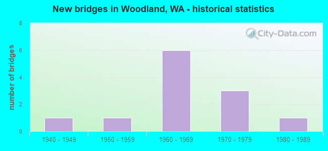
- New bridges - historical statistics
- 11940-1949
- 11950-1959
- 61960-1969
- 31970-1979
- 11980-1989


- Bridge Condition - Deck
- 62.5%Good
- 12.5%Satisfactory
- 12.5%Fair
- 12.5%Poor

- Bridge Condition - Superstructure
- 37.5%Good
- 37.5%Satisfactory
- 12.5%Fair
- 12.5%Poor

- Bridge Condition - Substructure
- 87.5%Good
- 12.5%Satisfactory

- Bridge Condition - Channel
- 50.0%Very good
- 50.0%Good
Find on map >> Show street view
Structure Number: 2559A, Location: 5.8 N JCT SR 501 (Lat: 45.888736, Lng: -122.732633), Route carried "on" structure: Interstate 5, Year Built: 1940, Status: Posted for load, Structure Length: 39.93m (131.00ft), Average Daily Traffic: 41,714 (year 2019), Truck Traffic: 16%, Average Future Daily Traffic: 60,401 (year 2039), Design Load: H 15, Features Intersected: LEWIS RIVER
Minimum Vertical Clearance: 5.49m (18.01ft), Kilometerpoint: 31.913, Lanes on structure: 3, Base Highway Network: Yes, Owner: State Highway Agency, Approaching Roadway Width: 14.6m (47.9ft), Navigation Control: Yes ( Vertical Clearance: 9.8m (32.2ft), Horizontal Clearance: 65.8m (215.9ft)), Material/Design: Steel continuous, Design/Construction: Truss - Thru, Number Of Spans In Main Unit: 3, Number Of Approach Spans: 10, Length of Maximum Span: 98.8m (324.1ft), Curb or Sidewalk Widths: Left: 1.2m (3.9ft), Right: 1.2m (3.9ft), Curb-To-Curb Width: 14.6m (47.9ft), Out-to-Out Width: 14.9m (48.9ft)
Condition: Deck: Satisfactory, Superstructure: Poor, Substructure: Satisfactory, Channel: Very good, Operating Rating: 29.9 metric tons, Method Used To Determine Operating Rating: Load Factor (LF), Inventory Rating: 18.1 metric tons, Method Used To Determine Inventory Rating: Load Factor (LF), Structural Evaluation: Meets minimum limits, Deck Geometry: Meets minimum limits, Waterway Adequacy: Equal to present desirable criteria, Approach Roadway Alignment: Equal to present desirable criteria, Bridge Posting: Required (Relationship of Operating Rating to Maximum Legal Load: 20.0 - 29.9% below), Length Of Structure Improvement: 39.93m (131.00ft), Designated Inspection Frequency: Every 24 months, Critical Feature Inspection Frequency: Every 24 months, Underwater Inspection Frequency: Every 60 months, Inspection Date: March 2021, Critical Feature Inspection Date: March 2021, Underwater Inspection Date: August 2019, Bridge Improvement Cost: $15,556,000, Roadway Improvement Cost: $3,111,000, Total Project Cost: $31,112,000 ( Estimate for 2022), Deck Structure Type: Concrete Cast-file-Place, Wearing Surface/Protective System: Wearing Surface: Bituminous, Membrane: Preformed Fabric
Find on map >> Show street view
Structure Number: 4885A, Location: 1.6 N JCT SR 503 (Lat: 45.927539, Lng: -122.756017), Route carried "on" structure: Interstate 5, Year Built: 1955, Status: Open, Structure Length: 3.17m (10.40ft), Average Daily Traffic: 33,399 (year 2019), Truck Traffic: 17%, Average Future Daily Traffic: 44,621 (year 2039), Design Load: HS 20+Mod, Features Intersected: LOG DUMP RD
Minimum Vertical Clearance: 30+ m (98+ ft), Kilometerpoint: 36.564, Lanes on structure: 3, Lanes under structure: 2, Base Highway Network: Yes, Owner: State Highway Agency, Approaching Roadway Width: 15.8m (51.8ft), Material/Design: Concrete continuous, Design/Construction: Tee Beam, Number Of Spans In Main Unit: 3, Length of Maximum Span: 12.2m (40.0ft), Curb or Sidewalk Widths: Left: 0.4m (1.3ft), Right: 0.4m (1.3ft), Curb-To-Curb Width: 17.1m (56.1ft), Out-to-Out Width: 18.8m (61.7ft)
Condition: Deck: Good, Superstructure: Satisfactory, Substructure: Good, Operating Rating: 50.8 metric tons, Method Used To Determine Operating Rating: Load Factor (LF), Inventory Rating: 29.9 metric tons, Method Used To Determine Inventory Rating: Load Factor (LF), Structural Evaluation: Equal to present minimum criteria, Deck Geometry: Equal to present minimum criteria, Underclear: Meets minimum limits, Approach Roadway Alignment: Equal to present desirable criteria, Length Of Structure Improvement: 3.17m (10.40ft), Designated Inspection Frequency: Every 24 months, Inspection Date: July 2020, Bridge Improvement Cost: $1,123,000, Roadway Improvement Cost: $225,000, Total Project Cost: $2,246,000 ( Estimate for 2014), Deck Structure Type: Concrete Cast-file-Place, Wearing Surface/Protective System: Wearing Surface: Bituminous
Find on map >> Show street view
Structure Number: 7064A, Location: 0.4 N CLARK CO (Lat: 45.905556, Lng: -122.742194), Route carried "on" structure: Interstate 5, Year Built: 1963, Status: Open, Structure Length: 5.12m (16.80ft), Average Daily Traffic: 32,604 (year 2019), Truck Traffic: 16%, Average Future Daily Traffic: 43,558 (year 2039), Design Load: HS 20, Features Intersected: SR 503
Minimum Vertical Clearance: 30+ m (98+ ft), Kilometerpoint: 33.925, Lanes on structure: 3, Lanes under structure: 5, Base Highway Network: Yes, Owner: State Highway Agency, Approaching Roadway Width: 16.5m (54.1ft), Skew: 1 degrees, Material/Design: Prestressed concrete, Design/Construction: Stringer/Multi-beam, Number Of Spans In Main Unit: 3, Length of Maximum Span: 25.0m (82.0ft), Curb-To-Curb Width: 13.7m (44.9ft), Out-to-Out Width: 14.6m (47.9ft)
Condition: Deck: Good, Superstructure: Good, Substructure: Good, Operating Rating: 62.6 metric tons, Method Used To Determine Operating Rating: Load Factor (LF), Inventory Rating: 37.2 metric tons, Method Used To Determine Inventory Rating: Load Factor (LF), Structural Evaluation: Better than present minimum criteria, Deck Geometry: High priority of corrective action, Underclear: Meets minimum limits, Approach Roadway Alignment: Equal to present desirable criteria, Length Of Structure Improvement: 5.12m (16.80ft), Designated Inspection Frequency: Every 24 months, Inspection Date: October 2021, Bridge Improvement Cost: $1,882,000, Roadway Improvement Cost: $376,000, Total Project Cost: $3,763,000 ( Estimate for 2014), Deck Structure Type: Concrete Cast-file-Place, Wearing Surface/Protective System: Wearing Surface: Bituminous, Membrane: Preformed Fabric
Find on map >> Show street view
Structure Number: 7064B, Location: 0.4 N CLARK CO (Lat: 45.905472, Lng: -122.742389), Route carried "on" structure: Interstate 5, Year Built: 1963, Status: Open, Structure Length: 5.12m (16.80ft), Average Daily Traffic: 32,604 (year 2019), Truck Traffic: 16%, Average Future Daily Traffic: 43,558 (year 2039), Design Load: HS 20, Features Intersected: SR 503
Minimum Vertical Clearance: 30+ m (98+ ft), Kilometerpoint: 33.925, Lanes on structure: 3, Lanes under structure: 5, Base Highway Network: Yes, Owner: State Highway Agency, Approaching Roadway Width: 16.5m (54.1ft), Skew: 1 degrees, Material/Design: Prestressed concrete, Design/Construction: Stringer/Multi-beam, Number Of Spans In Main Unit: 3, Length of Maximum Span: 25.0m (82.0ft), Curb-To-Curb Width: 13.7m (44.9ft), Out-to-Out Width: 14.6m (47.9ft)
Condition: Deck: Good, Superstructure: Satisfactory, Substructure: Good, Operating Rating: 62.6 metric tons, Method Used To Determine Operating Rating: Load Factor (LF), Inventory Rating: 37.2 metric tons, Method Used To Determine Inventory Rating: Load Factor (LF), Structural Evaluation: Equal to present minimum criteria, Deck Geometry: High priority of corrective action, Underclear: Meets minimum limits, Approach Roadway Alignment: Equal to present desirable criteria, Length Of Structure Improvement: 5.12m (16.80ft), Designated Inspection Frequency: Every 24 months, Inspection Date: October 2021, Bridge Improvement Cost: $1,882,000, Roadway Improvement Cost: $376,000, Total Project Cost: $3,763,000 ( Estimate for 2014), Deck Structure Type: Concrete Cast-file-Place, Wearing Surface/Protective System: Wearing Surface: Bituminous, Membrane: Preformed Fabric
Find on map >> Show street view
Structure Number: 8264C, Location: 5.8 N JCT SR 501 (Lat: 45.889358, Lng: -122.732636), Route carried "on" structure: Interstate 5, Year Built: 1968, Status: Open, Structure Length: 32.80m (107.61ft), Average Daily Traffic: 41,714 (year 2019), Truck Traffic: 16%, Average Future Daily Traffic: 60,401 (year 2039), Design Load: HS 20, Features Intersected: LEWIS RIVER
Minimum Vertical Clearance: 5.61m (18.41ft), Kilometerpoint: 31.978, Lanes on structure: 3, Base Highway Network: Yes, Owner: State Highway Agency, Approaching Roadway Width: 17.1m (56.1ft), Skew: 9 degrees, Navigation Control: Yes ( Vertical Clearance: 9.4m (30.8ft), Horizontal Clearance: 65.8m (215.9ft)), Material/Design: Steel continuous, Design/Construction: Truss - Thru, Number Of Spans In Main Unit: 3, Number Of Approach Spans: 4, Length of Maximum Span: 98.8m (324.1ft), Curb or Sidewalk Widths: Left: 0.2m (0.7ft), Right: 0.2m (0.7ft), Curb-To-Curb Width: 14.6m (47.9ft), Out-to-Out Width: 15.7m (51.5ft)
Condition: Deck: Fair, Superstructure: Good, Substructure: Good, Channel: Good, Operating Rating: 46.3 metric tons, Method Used To Determine Operating Rating: Load Factor (LF), Inventory Rating: 28.1 metric tons, Method Used To Determine Inventory Rating: Load Factor (LF), Structural Evaluation: Better than present minimum criteria, Deck Geometry: Meets minimum limits, Waterway Adequacy: Equal to present desirable criteria, Approach Roadway Alignment: Equal to present desirable criteria, Length Of Structure Improvement: 32.80m (107.61ft), Designated Inspection Frequency: Every 24 months, Critical Feature Inspection Frequency: Every 24 months, Underwater Inspection Frequency: Every 60 months, Inspection Date: March 2021, Critical Feature Inspection Date: March 2021, Underwater Inspection Date: August 2019, Bridge Improvement Cost: $14,822,000, Roadway Improvement Cost: $2,964,000, Total Project Cost: $29,644,000 ( Estimate for 2022), Deck Structure Type: Concrete Cast-file-Place, Wearing Surface/Protective System: Wearing Surface: Monolithic Concrete
Find on map >> Show street view
Structure Number: 8952A, Location: 1.6 N JCT SR 503 (Lat: 45.926808, Lng: -122.756417), Route carried "on" structure: Interstate 5, Year Built: 1972, Status: Open, Structure Length: 20.57m (67.49ft), Average Daily Traffic: 33,399 (year 2019), Truck Traffic: 17%, Average Future Daily Traffic: 44,621 (year 2039), Design Load: HS 20+Mod, Features Intersected: LOG DUMP RD & BN RY
Minimum Vertical Clearance: 30+ m (98+ ft), Kilometerpoint: 36.516, Lanes on structure: 3, Lanes under structure: 2, Base Highway Network: Yes, Owner: State Highway Agency, Approaching Roadway Width: 19.5m (64.0ft), Material/Design: Steel continuous, Design/Construction: Stringer/Multi-beam, Number Of Spans In Main Unit: 3, Length of Maximum Span: 84.4m (276.9ft), Curb or Sidewalk Widths: Left: 0.2m (0.7ft), Right: 0.2m (0.7ft), Curb-To-Curb Width: 15.8m (51.8ft), Out-to-Out Width: 16.9m (55.4ft)
Condition: Deck: Poor, Superstructure: Fair, Substructure: Good, Operating Rating: 63.5 metric tons, Method Used To Determine Operating Rating: Load Factor (LF), Inventory Rating: 38.1 metric tons, Method Used To Determine Inventory Rating: Load Factor (LF), Structural Evaluation: Somewhat better than minimum adequacy, Deck Geometry: Somewhat better than minimum adequacy, Underclear: Superior to present desirable criteria, Approach Roadway Alignment: Equal to present desirable criteria, Length Of Structure Improvement: 20.57m (67.49ft), Designated Inspection Frequency: Every 24 months, Other Special Inspection Frequency: Every 24 months, Inspection Date: May 2021, Other Special Inspection Date: May 2021, Bridge Improvement Cost: $8,910,000, Roadway Improvement Cost: $1,782,000, Total Project Cost: $17,820,000 ( Estimate for 2014), Deck Structure Type: Concrete Cast-file-Place, Wearing Surface/Protective System: Wearing Surface: Monolithic Concrete
Find on map >> Show street view
Structure Number: 13373A, Location: 23.2 N CLARK CO (Lat: 45.935194, Lng: -122.707278), Route carried "on" structure: State highway 503, Year Built: 1989, Status: Open, Structure Length: 1.95m (6.40ft), Average Daily Traffic: 5,089 (year 2019), Truck Traffic: 10%, Average Future Daily Traffic: 6,798 (year 2039), Design Load: HS 20+Mod, Features Intersected: ROSS CREEK
Minimum Vertical Clearance: 30+ m (98+ ft), Kilometerpoint: 82.334, Lanes on structure: 2, Base Highway Network: Yes, Owner: State Highway Agency, Approaching Roadway Width: 9.8m (32.2ft), Skew: 1 degrees, Material/Design: Prestressed concrete, Design/Construction: Slab, Number Of Spans In Main Unit: 1, Length of Maximum Span: 19.2m (63.0ft), Curb-To-Curb Width: 12.6m (41.3ft), Out-to-Out Width: 13.5m (44.3ft)
Condition: Deck: Good, Superstructure: Good, Substructure: Good, Channel: Very good, Operating Rating: 68.0 metric tons, Method Used To Determine Operating Rating: Load Factor (LF), Inventory Rating: 40.8 metric tons, Method Used To Determine Inventory Rating: Load Factor (LF), Structural Evaluation: Better than present minimum criteria, Deck Geometry: Somewhat better than minimum adequacy, Waterway Adequacy: Equal to present desirable criteria, Approach Roadway Alignment: Equal to present desirable criteria, Length Of Structure Improvement: 1.95m (6.40ft), Designated Inspection Frequency: Every 48 months, Inspection Date: May 2020, Bridge Improvement Cost: $435,000, Roadway Improvement Cost: $87,000, Total Project Cost: $870,000 ( Estimate for 2014), Deck Structure Type: Concrete Precast Panels, Wearing Surface/Protective System: Wearing Surface: Bituminous, Membrane: Preformed Fabric, Deck Protection: Epoxy Coated Reinforcing
Find on map >> Show street view
Structure Number: 82302, Location: 0.14 E SR 503 (MP 54.31) (Lat: 45.905833, Lng: -122.737222), Route carried "on" structure: County highway 30300, Year Built: 1966, Status: Open, Structure Length: 18.14m (59.51ft), Average Daily Traffic: 6,628 (year 2015), Truck Traffic: 12%, Average Future Daily Traffic: 8,500 (year 2035), Design Load: HS 20, Features Intersected: LEWIS RIVER, Facility Carried by Structure: EAST CC ST
Minimum Vertical Clearance: 30+ m (98+ ft), Kilometerpoint: 0.001, Lanes on structure: 2, Owner: County Highway Agency, Approaching Roadway Width: 8.5m (27.9ft), Material/Design: Steel continuous, Design/Construction: Stringer/Multi-beam, Number Of Spans In Main Unit: 3, Length of Maximum Span: 68.0m (223.1ft), Curb or Sidewalk Widths: Left: 0.8m (2.6ft), Right: 0.8m (2.6ft), Curb-To-Curb Width: 8.5m (27.9ft), Out-to-Out Width: 10.4m (34.1ft)
Condition: Deck: Good, Superstructure: Satisfactory, Substructure: Good, Channel: Good, Operating Rating: 40.8 metric tons, Method Used To Determine Operating Rating: Load Factor (LF), Inventory Rating: 24.5 metric tons, Method Used To Determine Inventory Rating: Load Factor (LF), Structural Evaluation: Equal to present minimum criteria, Deck Geometry: Meets minimum limits, Waterway Adequacy: Equal to present desirable criteria, Approach Roadway Alignment: Equal to present minimum criteria, Length Of Structure Improvement: 18.14m (59.51ft), Designated Inspection Frequency: Every 24 months, Underwater Inspection Frequency: Every 60 months, Other Special Inspection Frequency: Every 24 months, Inspection Date: March 2021, Underwater Inspection Date: September 2017, Other Special Inspection Date: March 2021, Bridge Improvement Cost: $3,570,000, Roadway Improvement Cost: $714,000, Total Project Cost: $7,140,000 ( Estimate for 2014), Deck Structure Type: Concrete Cast-file-Place, Wearing Surface/Protective System: Wearing Surface: Monolithic Concrete
Find on map >> Show street view
Structure Number: 7064A, Location: 26.5 N CLARK CO (Lat: 45.905556, Lng: -122.742194), Route carried "under" structure: State highway 503, Year Built: 1963, Structure Length: 0. m, Average Daily Traffic: 19,327 (year 2019), Truck Traffic: 4%, Features Intersected: SR 503, Facility Carried by Structure: I-5
Minimum Vertical Clearance: 5.00m (16.40ft), Kilometerpoint: 87.500, Lanes on structure: 3, Lanes under structure: 5, Material/Design: Prestressed concrete, Design/Construction: Stringer/Multi-beam, Length of Maximum Span: 25.0m (82.0ft)
Find on map >> Show street view
Structure Number: 7064B, Location: 26.5 N CLARK CO (Lat: 45.905472, Lng: -122.742389), Route carried "under" structure: State highway 503, Year Built: 1963, Structure Length: 0. m, Average Daily Traffic: 19,327 (year 2019), Truck Traffic: 4%, Features Intersected: SR 503, Facility Carried by Structure: I-5
Minimum Vertical Clearance: 4.90m (16.08ft), Kilometerpoint: 87.516, Lanes on structure: 3, Lanes under structure: 5, Material/Design: Prestressed concrete, Design/Construction: Stringer/Multi-beam, Length of Maximum Span: 25.0m (82.0ft)
Find on map >> Show street view
Structure Number: 8952B, Location: 1.6 N JCT SR 503 (Lat: 45.926139, Lng: -122.756861), Route carried "under" structure: Ramp Interstate 5, Year Built: 1972, Structure Length: 0. m, Average Daily Traffic: 3,772 (year 2019), Truck Traffic: 10%, Features Intersected: W-S RAMP TO I-5, Facility Carried by Structure: BN RY (NP)
Minimum Vertical Clearance: 4.83m (15.85ft), Kilometerpoint: 0.129, Lanes under structure: 1, Material/Design: Steel, Design/Construction: Stringer/Multi-beam, Length of Maximum Span: 11.6m (38.1ft)
Find on map >> Show street view
Structure Number: 8952C, Location: 1.6 N JCT SR 503 (Lat: 45.927256, Lng: -122.756953), Route carried "under" structure: County highway 5, Year Built: 1972, Structure Length: 0. m, Average Daily Traffic: 6,096 (year 2016), Truck Traffic: 10%, Features Intersected: DIKE ACCESS ROAD, Facility Carried by Structure: BNRR
Minimum Vertical Clearance: 4.75m (15.58ft), Kilometerpoint: 0.129, Lanes under structure: 2, Material/Design: Steel, Design/Construction: Stringer/Multi-beam, Length of Maximum Span: 12.8m (42.0ft)