Bridge Statistics for Woodridge, Illinois (IL)
Condition, Traffic, Stress, Structural Evaluation, Project Costs
- National Bridge Inventory (NBI) Statistics
- 31Number of bridges
- 364ft / 111mTotal length
- $1,745,000Total costs
- 1,310,425Total average daily traffic
- 191,176Total average daily truck traffic
- National Bridge Inventory (NBI) Registered Bridges for Woodridge
- No street view available for this location
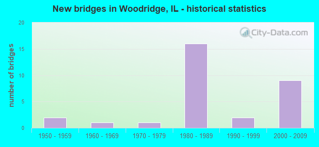
- New bridges - historical statistics
- 21950-1959
- 11960-1969
- 11970-1979
- 161980-1989
- 21990-1999
- 92000-2009

- Reconstructed bridges - Historical Statistics
- 21990-1999
- 12000-2009


- Bridge Condition - Deck
- 21.4%Good
- 71.4%Satisfactory
- 7.1%Fair

- Bridge Condition - Superstructure
- 21.4%Very good
- 50.0%Good
- 28.6%Satisfactory

- Bridge Condition - Substructure
- 7.1%Very good
- 85.7%Good
- 7.1%Satisfactory

- Bridge Condition - Channel
- 37.5%Very good
- 25.0%Good
- 25.0%Satisfactory
- 12.5%Fair

- Bridge Condition - Culverts
- 16.7%Very good
- 50.0%Good
- 33.3%Satisfactory
Find on map >> Show street view
Structure Number: 220088, Location: 1.1 M SW LEMONT RD (Lat: 41.707736, Lng: -88.024486), Route carried "on" structure: Other road , Year Built: 1959, Year Reconstructed: 1998, Status: Open, Structure Length: 10.63m (34.88ft), Average Daily Traffic: 7,900 (year 2020), Truck Traffic: 4%, Average Future Daily Traffic: 9,915 (year 2032), Design Load: HS 20, Features Intersected: I- 55, Facility Carried by Structure: WOODWARD AVE
Minimum Vertical Clearance: 30+ m (98+ ft), Kilometerpoint: 7.258, Lanes on structure: 4, Lanes under structure: 10, Owner: State Highway Agency, Approaching Roadway Width: 7.9m (25.9ft), Skew: 30 degrees, Material/Design: Steel continuous, Design/Construction: Stringer/Multi-beam, Number Of Spans In Main Unit: 2, Length of Maximum Span: 48.8m (160.1ft), Curb or Sidewalk Widths: Left: 4.2m (13.8ft), Right: 4.2m (13.8ft), Curb-To-Curb Width: 16.2m (53.1ft), Out-to-Out Width: 24.7m (81.0ft)
Condition: Deck: Good, Superstructure: Satisfactory, Substructure: Satisfactory, Operating Rating: 59.9 metric tons, Method Used To Determine Operating Rating: Load Factor (LF) rating reported by rating factor (RF) method using MS18 loading, Inventory Rating: 36.0 metric tons, Method Used To Determine Inventory Rating: Load Factor (LF) rating reported by rating factor (RF) method using MS18 loading, Structural Evaluation: Equal to present minimum criteria, Deck Geometry: Meets minimum limits, Underclear: Equal to present minimum criteria, Approach Roadway Alignment: Equal to present desirable criteria, Designated Inspection Frequency: Every 24 months, Inspection Date: March 2021, Deck Structure Type: Concrete Cast-file-Place, Wearing Surface/Protective System: Deck Protection: Other Coated Reinforcing
Find on map >> Show street view
Structure Number: 220159, Location: 2.2 M S OF US 34 (Lat: 41.771486, Lng: -88.069694), Route carried "on" structure: State highway 53, Year Built: 1987, Status: Open, Structure Length: 1.01m (3.31ft), Average Daily Traffic: 22,300 (year 2021), Truck Traffic: 6%, Average Future Daily Traffic: 32,083 (year 2032), Features Intersected: PRENTISS CREEK
Minimum Vertical Clearance: 30+ m (98+ ft), Kilometerpoint: 77.085, Lanes on structure: 4, Base Highway Network: Yes, Owner: State Highway Agency, Approaching Roadway Width: 20.7m (67.9ft), Skew: 20 degrees, Material/Design: Concrete continuous, Design/Construction: Culvert, Number Of Spans In Main Unit: 4, Length of Maximum Span: 2.7m (8.9ft)
Condition: Channel: Fair, Culverts: Satisfactory, Operating Rating: 68.4 metric tons, Method Used To Determine Operating Rating: Load Factor (LF) rating reported by rating factor (RF) method using MS18 loading, Inventory Rating: 41.5 metric tons, Method Used To Determine Inventory Rating: Load Factor (LF) rating reported by rating factor (RF) method using MS18 loading, Structural Evaluation: Equal to present minimum criteria, Waterway Adequacy: Equal to present minimum criteria, Approach Roadway Alignment: Equal to present desirable criteria, Designated Inspection Frequency: Every 24 months, Inspection Date: July 2021
Find on map >> Show street view
Structure Number: 220185, Location: 1.2 MI E. ILL RTE 53 (Lat: 41.770981, Lng: -88.044672), Route carried "on" structure: Interstate 355, Year Built: 1988, Status: Open, Structure Length: 1.06m (3.48ft), Average Daily Traffic: 53,150 (year 2020), Truck Traffic: 13%, Average Future Daily Traffic: 66,617 (year 2032), Design Load: HS 20, Features Intersected: PRENTISS CREEK
Minimum Vertical Clearance: 30+ m (98+ ft), Kilometerpoint: 27.712, Lanes on structure: 6, Base Highway Network: Yes, Toll: On toll road, Owner: State Toll Authority, Approaching Roadway Width: 39.3m (128.9ft), Skew: 2 degrees, Material/Design: Concrete, Design/Construction: Culvert, Number Of Spans In Main Unit: 3, Length of Maximum Span: 3.0m (9.8ft)
Condition: Channel: Satisfactory, Culverts: Satisfactory, Operating Rating: 89.7 metric tons, Method Used To Determine Operating Rating: Load Factor (LF) rating reported by rating factor (RF) method using MS18 loading, Inventory Rating: 53.8 metric tons, Method Used To Determine Inventory Rating: Load Factor (LF) rating reported by rating factor (RF) method using MS18 loading, Structural Evaluation: Equal to present minimum criteria, Waterway Adequacy: Superior to present desirable criteria, Approach Roadway Alignment: Equal to present desirable criteria, Designated Inspection Frequency: Every 24 months, Inspection Date: August 2019, Deck Structure Type: Concrete Cast-file-Place
Find on map >> Show street view
Structure Number: 222006, Location: 1 M W OF LEMONT RD (Lat: 41.705567, Lng: -88.028267), Route carried "on" structure: Other road , Year Built: 2007, Status: Open, Structure Length: 12.51m (41.04ft), Average Daily Traffic: 28,100 (year 2021), Average Future Daily Traffic: 87,567 (year 2032), Design Load: HS 20, Features Intersected: I- 55, Facility Carried by Structure: I- 55 NB TO I-355
Minimum Vertical Clearance: 5.03m (16.50ft), Kilometerpoint: 1.722, Lanes on structure: 1, Lanes under structure: 6, Base Highway Network: Yes (Inventory Route: 10055043, Subroute: 20), Toll: On toll road, Owner: State Highway Agency, Approaching Roadway Width: 10.4m (34.1ft), Skew: 3 degrees, Material/Design: Steel continuous, Design/Construction: Stringer/Multi-beam, Number Of Spans In Main Unit: 2, Length of Maximum Span: 54.8m (179.8ft), Curb-To-Curb Width: 10.4m (34.1ft), Out-to-Out Width: 11.3m (37.1ft)
Condition: Deck: Satisfactory, Superstructure: Good, Substructure: Good, Operating Rating: 72.9 metric tons, Method Used To Determine Operating Rating: Load Factor (LF) rating reported by rating factor (RF) method using MS18 loading, Inventory Rating: 41.5 metric tons, Method Used To Determine Inventory Rating: Load Factor (LF) rating reported by rating factor (RF) method using MS18 loading, Structural Evaluation: Better than present minimum criteria, Deck Geometry: Meets minimum limits, Underclear: High priority of corrective action, Approach Roadway Alignment: Equal to present desirable criteria, Designated Inspection Frequency: Every 24 months, Inspection Date: April 2020, Deck Structure Type: Concrete Cast-file-Place, Wearing Surface/Protective System: Deck Protection: Epoxy Coated Reinforcing
Find on map >> Show street view
Structure Number: 223012, Location: 0.3 MI W IL 53 (Lat: 41.749717, Lng: -88.068858), Route carried "on" structure: Other road , Year Built: 1960, Year Reconstructed: 2012, Status: Open, Structure Length: 3.69m (12.11ft), Average Daily Traffic: 25,800 (year 2020), Truck Traffic: 8%, Average Future Daily Traffic: 35,425 (year 2032), Design Load: HS 25 or greater, Features Intersected: E BRANCH DU PAGE RV, Facility Carried by Structure: 75TH STREET
Minimum Vertical Clearance: 30+ m (98+ ft), Kilometerpoint: 12.987, Lanes on structure: 4, Base Highway Network: Yes, Owner: County Highway Agency, Approaching Roadway Width: 20.4m (66.9ft), Skew: 30 degrees, Material/Design: Prestressed concrete, Design/Construction: Box Beam or Girders - Multiple, Number Of Spans In Main Unit: 3, Length of Maximum Span: 12.0m (39.4ft), Curb-To-Curb Width: 20.4m (66.9ft), Out-to-Out Width: 25.7m (84.3ft)
Condition: Deck: Fair, Superstructure: Good, Substructure: Good, Channel: Satisfactory, Operating Rating: 50.2 metric tons, Method Used To Determine Operating Rating: Load and Resistance Factor Rating (LRFR) rating reported by rating factor(RF) method using HL-93 loadings, Inventory Rating: 38.6 metric tons, Method Used To Determine Inventory Rating: Load and Resistance Factor Rating (LRFR) rating reported by rating factor(RF) method using HL-93 loadings, Structural Evaluation: Better than present minimum criteria, Deck Geometry: Superior to present desirable criteria, Waterway Adequacy: Equal to present desirable criteria, Approach Roadway Alignment: Equal to present desirable criteria, Designated Inspection Frequency: Every 24 months, Inspection Date: September 2021, Deck Structure Type: Concrete Precast Panels, Wearing Surface/Protective System: Wearing Surface: Integral Concrete, Deck Protection: Epoxy Coated Reinforcing
Find on map >> Show street view
Structure Number: 223052, Location: 0.40 MI W IL-53 (Lat: 41.759339, Lng: -88.071422), Route carried "on" structure: Other road , Year Built: 1999, Status: Open, Structure Length: 4.42m (14.50ft), Average Daily Traffic: 11,700 (year 2020), Truck Traffic: 5%, Average Future Daily Traffic: 21,723 (year 2032), Design Load: HS 20, Features Intersected: E BR DUPAGE RIVER, Facility Carried by Structure: HOBSON RD
Minimum Vertical Clearance: 30+ m (98+ ft), Kilometerpoint: 4.989, Lanes on structure: 2, Base Highway Network: Yes, Owner: County Highway Agency, Approaching Roadway Width: 12.2m (40.0ft), Skew: 20 degrees, Material/Design: Steel, Design/Construction: Stringer/Multi-beam, Number Of Spans In Main Unit: 1, Length of Maximum Span: 43.4m (142.4ft), Curb or Sidewalk Widths: Left: 0.0m, Right: 3.0m (9.8ft), Curb-To-Curb Width: 11.2m (36.7ft), Out-to-Out Width: 15.5m (50.9ft)
Condition: Deck: Satisfactory, Superstructure: Very good, Substructure: Very good, Channel: Good, Operating Rating: 97.2 metric tons, Method Used To Determine Operating Rating: Load Factor (LF) rating reported by rating factor (RF) method using MS18 loading, Inventory Rating: 64.8 metric tons, Method Used To Determine Inventory Rating: Load Factor (LF) rating reported by rating factor (RF) method using MS18 loading, Structural Evaluation: Equal to present desirable criteria, Deck Geometry: Meets minimum limits, Waterway Adequacy: Superior to present desirable criteria, Approach Roadway Alignment: Equal to present desirable criteria, Designated Inspection Frequency: Every 24 months, Inspection Date: September 2020, Deck Structure Type: Concrete Cast-file-Place, Wearing Surface/Protective System: Deck Protection: Epoxy Coated Reinforcing
Find on map >> Show street view
Structure Number: 225004, Location: 0.3 Mi. N. Hobson Rd (Lat: 41.773322, Lng: -88.051625), Route carried "on" structure: City street , Year Built: 1986, Status: Open, Structure Length: 1.00m (3.28ft), Average Daily Traffic: 1,300 (year 2020), Truck Traffic: 6%, Average Future Daily Traffic: 1,200 (year 2038), Design Load: HS 20+Mod, Features Intersected: Prentiss Creek, Facility Carried by Structure: Walnut Avenue
Minimum Vertical Clearance: 30+ m (98+ ft), Kilometerpoint: 0.080, Lanes on structure: 2, Owner: City or Municipal Highway Agency, Approaching Roadway Width: 7.9m (25.9ft), Material/Design: Concrete, Design/Construction: Culvert, Number Of Spans In Main Unit: 3, Length of Maximum Span: 3.0m (9.8ft)
Condition: Channel: Very good, Culverts: Good, Operating Rating: 50.9 metric tons, Method Used To Determine Operating Rating: Load Factor (LF) rating reported by rating factor (RF) method using MS18 loading, Inventory Rating: 30.5 metric tons, Method Used To Determine Inventory Rating: Load Factor (LF) rating reported by rating factor (RF) method using MS18 loading, Structural Evaluation: Better than present minimum criteria, Waterway Adequacy: Superior to present desirable criteria, Approach Roadway Alignment: Equal to present desirable criteria, Designated Inspection Frequency: Every 24 months, Inspection Date: March 2020
Find on map >> Show street view
Structure Number: 225005, Location: 1.2 Mi. E. Ill. 53 (Lat: 41.771986, Lng: -88.047175), Route carried "on" structure: Other road , Year Built: 1986, Status: Open, Structure Length: 1.06m (3.48ft), Average Daily Traffic: 19,100 (year 2020), Truck Traffic: 45%, Average Future Daily Traffic: 37,080 (year 2038), Design Load: HS 20+Mod, Features Intersected: Prentiss Creek, Facility Carried by Structure: 63rd Street
Minimum Vertical Clearance: 30+ m (98+ ft), Kilometerpoint: 0.113, Lanes on structure: 5, Base Highway Network: Yes, Owner: County Highway Agency, Approaching Roadway Width: 14.6m (47.9ft), Skew: 2 degrees, Material/Design: Concrete, Design/Construction: Culvert, Number Of Spans In Main Unit: 3, Length of Maximum Span: 3.3m (10.8ft)
Condition: Channel: Very good, Culverts: Very good, Operating Rating: 54.1 metric tons, Method Used To Determine Operating Rating: Field evaluation and documented engineering judgment, Inventory Rating: 32.4 metric tons, Method Used To Determine Inventory Rating: Field evaluation and documented engineering judgment, Structural Evaluation: Equal to present desirable criteria, Waterway Adequacy: Superior to present desirable criteria, Approach Roadway Alignment: Equal to present desirable criteria, Designated Inspection Frequency: Every 24 months, Inspection Date: May 2020
Find on map >> Show street view
Structure Number: 226012, Location: 0.1 MI W OF WOODWARD AVE (Lat: 41.696469, Lng: -88.020358), Route carried "on" structure: Other road , Year Built: 1998, Status: Open, Structure Length: 1.25m (4.10ft), Average Daily Traffic: 4,200 (year 2020), Truck Traffic: 18%, Average Future Daily Traffic: 5,110 (year 2032), Features Intersected: Black Partridge Creek, Facility Carried by Structure: International Park
Minimum Vertical Clearance: 30+ m (98+ ft), Kilometerpoint: 1.062, Lanes on structure: 4, Owner: City or Municipal Highway Agency, Approaching Roadway Width: 14.6m (47.9ft), Skew: 35 degrees, Material/Design: Concrete, Design/Construction: Culvert, Number Of Spans In Main Unit: 4, Length of Maximum Span: 0.0m
Condition: Channel: Good, Culverts: Good, Operating Rating: 54.1 metric tons, Method Used To Determine Operating Rating: Field evaluation and documented engineering judgment, Inventory Rating: 32.4 metric tons, Method Used To Determine Inventory Rating: Field evaluation and documented engineering judgment, Structural Evaluation: Better than present minimum criteria, Waterway Adequacy: Better than present minimum criteria, Approach Roadway Alignment: Equal to present desirable criteria, Designated Inspection Frequency: Every 24 months, Inspection Date: October 2021
Find on map >> Show street view
Structure Number: 2274, Location: .7 MI N 75TH STREET (Lat: 41.758553, Lng: -88.048811), Route carried "on" structure: Other road , Year Built: 1973, Status: Open, Structure Length: 0.71m (2.33ft), Average Daily Traffic: 4,050 (year 2020), Truck Traffic: 7%, Average Future Daily Traffic: 6,907 (year 2032), Features Intersected: CREEK PEDESTRIAN WLK, Facility Carried by Structure: WOODRIDGE DRIVE
Minimum Vertical Clearance: 30+ m (98+ ft), Kilometerpoint: 2.366, Lanes on structure: 4, Owner: City or Municipal Highway Agency, Approaching Roadway Width: 24.4m (80.1ft), Skew: 31 degrees, Material/Design: Concrete, Design/Construction: Culvert, Number Of Spans In Main Unit: 2, Length of Maximum Span: 3.0m (9.8ft), Curb or Sidewalk Widths: Left: 3.0m (9.8ft), Right: 3.0m (9.8ft)
Condition: Channel: Very good, Culverts: Good, Operating Rating: 54.1 metric tons, Method Used To Determine Operating Rating: Field evaluation and documented engineering judgment, Inventory Rating: 32.4 metric tons, Method Used To Determine Inventory Rating: Field evaluation and documented engineering judgment, Structural Evaluation: Better than present minimum criteria, Waterway Adequacy: Superior to present desirable criteria, Approach Roadway Alignment: Equal to present desirable criteria, Designated Inspection Frequency: Every 48 months, Inspection Date: Febuary 2018
Find on map >> Show street view
Structure Number: 229982, Location: 1M.E.OF IL-53 (Lat: 41.775844, Lng: -88.049383), Route carried "on" structure: Interstate 355, Year Built: 1989, Status: Open, Structure Length: 4.33m (14.21ft), Average Daily Traffic: 115,400 (year 2020), Truck Traffic: 12%, Average Future Daily Traffic: 146,937 (year 2032), Features Intersected: JACKSON AVE.
Minimum Vertical Clearance: 30+ m (98+ ft), Kilometerpoint: 28.469, Lanes on structure: 9, Lanes under structure: 2, Base Highway Network: Yes, Toll: On toll road, Owner: State Toll Authority, Approaching Roadway Width: 51.8m (169.9ft), Skew: 32 degrees, Material/Design: Prestressed concrete, Design/Construction: Stringer/Multi-beam, Number Of Spans In Main Unit: 3, Length of Maximum Span: 19.2m (63.0ft), Curb-To-Curb Width: 51.1m (167.7ft), Out-to-Out Width: 52.6m (172.6ft)
Condition: Deck: Satisfactory, Superstructure: Very good, Substructure: Good, Operating Rating: 90.7 metric tons, Method Used To Determine Operating Rating: Load Factor (LF) rating reported by rating factor (RF) method using MS18 loading, Inventory Rating: 54.4 metric tons, Method Used To Determine Inventory Rating: Load Factor (LF) rating reported by rating factor (RF) method using MS18 loading, Structural Evaluation: Better than present minimum criteria, Deck Geometry: Superior to present desirable criteria, Underclear: Somewhat better than minimum adequacy, Approach Roadway Alignment: Equal to present desirable criteria, Designated Inspection Frequency: Every 24 months, Inspection Date: April 2020, Deck Structure Type: Concrete Cast-file-Place
Find on map >> Show street view
Structure Number: 229983, Location: 0.1M.E.OF HOBSON RD. (Lat: 41.772050, Lng: -88.046086), Route carried "on" structure: Other road , Year Built: 1989, Status: Open, Structure Length: 9.20m (30.18ft), Average Daily Traffic: 19,100 (year 2020), Truck Traffic: 45%, Average Future Daily Traffic: 34,088 (year 2032), Design Load: HS 20, Features Intersected: I-355, Facility Carried by Structure: 63RD. ST.
Minimum Vertical Clearance: 30+ m (98+ ft), Kilometerpoint: 0.209, Lanes on structure: 6, Lanes under structure: 5, Base Highway Network: Yes, Owner: County Highway Agency, Approaching Roadway Width: 25.0m (82.0ft), Skew: 31 degrees, Material/Design: Prestressed concrete, Design/Construction: Box Beam or Girders - Multiple, Number Of Spans In Main Unit: 2, Length of Maximum Span: 46.0m (150.9ft), Curb or Sidewalk Widths: Left: 1.5m (4.9ft), Right: 1.5m (4.9ft), Curb-To-Curb Width: 24.4m (80.1ft), Out-to-Out Width: 29.2m (95.8ft)
Condition: Deck: Satisfactory, Superstructure: Satisfactory, Substructure: Good, Operating Rating: 62.9 metric tons, Method Used To Determine Operating Rating: Load Factor (LF) rating reported by rating factor (RF) method using MS18 loading, Inventory Rating: 37.6 metric tons, Method Used To Determine Inventory Rating: Load Factor (LF) rating reported by rating factor (RF) method using MS18 loading, Structural Evaluation: Equal to present minimum criteria, Deck Geometry: Somewhat better than minimum adequacy, Underclear: Equal to present minimum criteria, Approach Roadway Alignment: Equal to present desirable criteria, Designated Inspection Frequency: Every 24 months, Inspection Date: April 2020, Deck Structure Type: Concrete Cast-file-Place, Wearing Surface/Protective System: Deck Protection: Epoxy Coated Reinforcing
Find on map >> Show street view
Structure Number: 229984, Location: 1.5M.E.OF IL-53 (Lat: 41.757906, Lng: -88.035628), Route carried "on" structure: Other road , Year Built: 1989, Status: Open, Structure Length: 6.43m (21.10ft), Average Daily Traffic: 4,050 (year 2020), Truck Traffic: 4%, Average Future Daily Traffic: 6,684 (year 2032), Features Intersected: I-355, Facility Carried by Structure: 71ST.ST.
Minimum Vertical Clearance: 30+ m (98+ ft), Kilometerpoint: 0.435, Lanes on structure: 4, Lanes under structure: 6, Owner: State Toll Authority, Approaching Roadway Width: 12.2m (40.0ft), Material/Design: Prestressed concrete, Design/Construction: Stringer/Multi-beam, Number Of Spans In Main Unit: 2, Length of Maximum Span: 32.0m (105.0ft), Curb or Sidewalk Widths: Left: 1.5m (4.9ft), Right: 1.5m (4.9ft), Curb-To-Curb Width: 11.6m (38.1ft), Out-to-Out Width: 15.9m (52.2ft)
Condition: Deck: Good, Superstructure: Satisfactory, Substructure: Good, Operating Rating: 66.7 metric tons, Method Used To Determine Operating Rating: Load Factor (LF) rating reported by rating factor (RF) method using MS18 loading, Inventory Rating: 40.2 metric tons, Method Used To Determine Inventory Rating: Load Factor (LF) rating reported by rating factor (RF) method using MS18 loading, Structural Evaluation: Equal to present minimum criteria, Deck Geometry: High priority of replacement, Underclear: Somewhat better than minimum adequacy, Approach Roadway Alignment: Equal to present desirable criteria, Length Of Structure Improvement: 7.71m (25.30ft), Designated Inspection Frequency: Every 24 months, Inspection Date: April 2020, Bridge Improvement Cost: $1,163,000, Roadway Improvement Cost: $116,000, Total Project Cost: $1,745,000, Deck Structure Type: Concrete Cast-file-Place
Find on map >> Show street view
Structure Number: 229985, Location: 1.25M.E.OF IL-53 (Lat: 41.750464, Lng: -88.035706), Route carried "on" structure: Other road , Year Built: 1989, Status: Open, Structure Length: 8.05m (26.41ft), Average Daily Traffic: 22,600 (year 2020), Truck Traffic: 6%, Average Future Daily Traffic: 34,534 (year 2032), Design Load: HS 20, Features Intersected: I-355, Facility Carried by Structure: 75TH. ST.
Minimum Vertical Clearance: 30+ m (98+ ft), Kilometerpoint: 15.787, Lanes on structure: 8, Lanes under structure: 6, Base Highway Network: Yes, Owner: County Highway Agency, Approaching Roadway Width: 32.9m (107.9ft), Skew: 30 degrees, Material/Design: Prestressed concrete, Design/Construction: Box Beam or Girders - Multiple, Number Of Spans In Main Unit: 2, Length of Maximum Span: 40.2m (131.9ft), Curb or Sidewalk Widths: Left: 1.5m (4.9ft), Right: 1.5m (4.9ft), Curb-To-Curb Width: 30.5m (100.1ft), Out-to-Out Width: 36.6m (120.1ft)
Condition: Deck: Satisfactory, Superstructure: Satisfactory, Substructure: Good, Operating Rating: 67.1 metric tons, Method Used To Determine Operating Rating: Load Factor (LF) rating reported by rating factor (RF) method using MS18 loading, Inventory Rating: 40.2 metric tons, Method Used To Determine Inventory Rating: Load Factor (LF) rating reported by rating factor (RF) method using MS18 loading, Structural Evaluation: Equal to present minimum criteria, Deck Geometry: Somewhat better than minimum adequacy, Underclear: Somewhat better than minimum adequacy, Approach Roadway Alignment: Equal to present desirable criteria, Designated Inspection Frequency: Every 24 months, Inspection Date: April 2020, Deck Structure Type: Concrete Cast-file-Place, Wearing Surface/Protective System: Deck Protection: Epoxy Coated Reinforcing
Find on map >> Show street view
Structure Number: 229986, Location: 1.5M.E.OF IL-53 (Lat: 41.736081, Lng: -88.034914), Route carried "on" structure: Other road , Year Built: 1989, Year Reconstructed: 2002, Status: Open, Structure Length: 9.97m (32.71ft), Average Daily Traffic: 7,350 (year 2020), Truck Traffic: 39%, Average Future Daily Traffic: 16,710 (year 2032), Features Intersected: I-355, Facility Carried by Structure: 83RD.ST.
Minimum Vertical Clearance: 30+ m (98+ ft), Kilometerpoint: 2.285, Lanes on structure: 2, Lanes under structure: 6, Base Highway Network: Yes, Owner: State Toll Authority, Approaching Roadway Width: 9.1m (29.9ft), Material/Design: Prestressed concrete, Design/Construction: Stringer/Multi-beam, Number Of Spans In Main Unit: 2, Length of Maximum Span: 42.4m (139.1ft), Curb or Sidewalk Widths: Left: 4.3m (14.1ft), Right: 0.0m, Curb-To-Curb Width: 14.6m (47.9ft), Out-to-Out Width: 19.4m (63.6ft)
Condition: Deck: Satisfactory, Superstructure: Very good, Substructure: Good, Operating Rating: 56.7 metric tons, Method Used To Determine Operating Rating: Load Factor (LF) rating reported by rating factor (RF) method using MS18 loading, Inventory Rating: 34.0 metric tons, Method Used To Determine Inventory Rating: Load Factor (LF) rating reported by rating factor (RF) method using MS18 loading, Structural Evaluation: Better than present minimum criteria, Deck Geometry: Superior to present desirable criteria, Underclear: Somewhat better than minimum adequacy, Approach Roadway Alignment: Equal to present desirable criteria, Designated Inspection Frequency: Every 24 months, Inspection Date: April 2020, Deck Structure Type: Concrete Cast-file-Place
Find on map >> Show street view
Structure Number: 990334, Location: 1M E OF JOLIET RD (Lat: 41.691158, Lng: -88.030017), Route carried "on" structure: Interstate 355, Year Built: 2007, Status: Open, Structure Length: 4.09m (13.42ft), Average Daily Traffic: 32,950 (year 2021), Truck Traffic: 15%, Average Future Daily Traffic: 43,784 (year 2032), Design Load: HS 20, Features Intersected: INTERNATIONAL PRKY
Minimum Vertical Clearance: 30+ m (98+ ft), Kilometerpoint: 19.296, Lanes on structure: 4, Lanes under structure: 2, Base Highway Network: Yes, Toll: On toll road, Owner: State Toll Authority, Approaching Roadway Width: 23.6m (77.4ft), Material/Design: Steel continuous, Design/Construction: Stringer/Multi-beam, Number Of Spans In Main Unit: 1, Length of Maximum Span: 39.5m (129.6ft), Curb-To-Curb Width: 22.7m (74.5ft), Out-to-Out Width: 23.6m (77.4ft)
Condition: Deck: Satisfactory, Superstructure: Good, Substructure: Good, Operating Rating: 62.5 metric tons, Method Used To Determine Operating Rating: Load Factor (LF) rating reported by rating factor (RF) method using MS18 loading, Inventory Rating: 37.6 metric tons, Method Used To Determine Inventory Rating: Load Factor (LF) rating reported by rating factor (RF) method using MS18 loading, Structural Evaluation: Better than present minimum criteria, Deck Geometry: Superior to present desirable criteria, Underclear: High priority of corrective action, Approach Roadway Alignment: Equal to present desirable criteria, Designated Inspection Frequency: Every 24 months, Inspection Date: August 2019, Deck Structure Type: Concrete Cast-file-Place
Find on map >> Show street view
Structure Number: 990335, Location: 1M E OF JOLIET RD (Lat: 41.697175, Lng: -88.030186), Route carried "on" structure: Interstate 355, Year Built: 2008, Status: Open, Structure Length: 5.96m (19.55ft), Average Daily Traffic: 32,950 (year 2021), Truck Traffic: 15%, Average Future Daily Traffic: 46,734 (year 2032), Design Load: HS 20, Features Intersected: BN&SF RR
Minimum Vertical Clearance: 30+ m (98+ ft), Kilometerpoint: 19.778, Lanes on structure: 2, Base Highway Network: Yes, Toll: On toll road, Owner: State Toll Authority, Approaching Roadway Width: 26.3m (86.3ft), Skew: 3 degrees, Material/Design: Prestressed concrete continuous, Design/Construction: Stringer/Multi-beam, Number Of Spans In Main Unit: 3, Length of Maximum Span: 24.7m (81.0ft), Curb-To-Curb Width: 26.3m (86.3ft), Out-to-Out Width: 27.3m (89.6ft)
Condition: Deck: Good, Superstructure: Good, Substructure: Good, Operating Rating: 59.9 metric tons, Method Used To Determine Operating Rating: Load Factor (LF) rating reported by rating factor (RF) method using MS18 loading, Inventory Rating: 36.0 metric tons, Method Used To Determine Inventory Rating: Load Factor (LF) rating reported by rating factor (RF) method using MS18 loading, Structural Evaluation: Better than present minimum criteria, Deck Geometry: Superior to present desirable criteria, Underclear: High priority of corrective action, Approach Roadway Alignment: Equal to present desirable criteria, Designated Inspection Frequency: Every 24 months, Inspection Date: September 2019, Deck Structure Type: Concrete Cast-file-Place
Find on map >> Show street view
Structure Number: 990336, Location: 1.3M S OF BOUGHTON (Lat: 41.703894, Lng: -88.030819), Route carried "on" structure: Interstate 355, Year Built: 2007, Status: Open, Structure Length: 10.87m (35.66ft), Average Daily Traffic: 32,950 (year 2021), Truck Traffic: 15%, Average Future Daily Traffic: 43,784 (year 2032), Design Load: HS 20, Features Intersected: I-55
Minimum Vertical Clearance: 30+ m (98+ ft), Kilometerpoint: 20.309, Lanes on structure: 4, Lanes under structure: 10, Base Highway Network: Yes, Toll: On toll road, Owner: State Toll Authority, Approaching Roadway Width: 30.4m (99.7ft), Material/Design: Steel continuous, Design/Construction: Stringer/Multi-beam, Number Of Spans In Main Unit: 2, Length of Maximum Span: 45.3m (148.6ft), Curb-To-Curb Width: 30.4m (99.7ft), Out-to-Out Width: 30.4m (99.7ft)
Condition: Deck: Satisfactory, Superstructure: Good, Substructure: Good, Operating Rating: 69.3 metric tons, Method Used To Determine Operating Rating: Load Factor (LF) rating reported by rating factor (RF) method using MS18 loading, Inventory Rating: 41.5 metric tons, Method Used To Determine Inventory Rating: Load Factor (LF) rating reported by rating factor (RF) method using MS18 loading, Structural Evaluation: Better than present minimum criteria, Deck Geometry: Superior to present desirable criteria, Underclear: Equal to present minimum criteria, Approach Roadway Alignment: Equal to present desirable criteria, Designated Inspection Frequency: Every 24 months, Inspection Date: April 2020, Deck Structure Type: Concrete Cast-file-Place
Find on map >> Show street view
Structure Number: 993011, Location: 1.5M S OF BOUGHTON (Lat: 41.702333, Lng: -88.030528), Route carried "on" structure: Interstate 355, Year Built: 2007, Status: Open, Structure Length: 3.70m (12.14ft), Average Daily Traffic: 65,900 (year 2021), Truck Traffic: 15%, Average Future Daily Traffic: 87,567 (year 2032), Design Load: HS 20, Features Intersected: I55 RMP TO NBI355
Minimum Vertical Clearance: 30+ m (98+ ft), Kilometerpoint: 20.197, Lanes on structure: 6, Lanes under structure: 1, Base Highway Network: Yes, Toll: On toll road, Owner: State Toll Authority, Approaching Roadway Width: 14.6m (47.9ft), Material/Design: Steel continuous, Design/Construction: Stringer/Multi-beam, Number Of Spans In Main Unit: 1, Length of Maximum Span: 36.4m (119.4ft), Curb-To-Curb Width: 14.6m (47.9ft), Out-to-Out Width: 14.6m (47.9ft)
Condition: Deck: Satisfactory, Superstructure: Good, Substructure: Good, Operating Rating: 90.7 metric tons, Method Used To Determine Operating Rating: Load Factor (LF) rating reported by rating factor (RF) method using MS18 loading, Inventory Rating: 54.4 metric tons, Method Used To Determine Inventory Rating: Load Factor (LF) rating reported by rating factor (RF) method using MS18 loading, Structural Evaluation: Better than present minimum criteria, Deck Geometry: High priority of replacement, Underclear: High priority of corrective action, Approach Roadway Alignment: Equal to present desirable criteria, Designated Inspection Frequency: Every 24 months, Inspection Date: April 2020, Deck Structure Type: Concrete Cast-file-Place
Find on map >> Show street view
Structure Number: 999944, Location: 1.3M S OF BOUGHTON (Lat: 41.704225, Lng: -88.030881), Route carried "on" structure: Interstate 355, Year Built: 1989, Status: Open, Structure Length: 10.97m (35.99ft), Average Daily Traffic: 32,950 (year 2021), Truck Traffic: 15%, Average Future Daily Traffic: 43,784 (year 2032), Features Intersected: I-55
Minimum Vertical Clearance: 30+ m (98+ ft), Kilometerpoint: 20.325, Lanes on structure: 4, Lanes under structure: 10, Base Highway Network: Yes, Toll: On toll road, Owner: State Toll Authority, Approaching Roadway Width: 18.6m (61.0ft), Skew: 30 degrees, Material/Design: Steel, Design/Construction: Stringer/Multi-beam, Number Of Spans In Main Unit: 2, Length of Maximum Span: 54.9m (180.1ft), Curb-To-Curb Width: 18.0m (59.1ft), Out-to-Out Width: 19.2m (63.0ft)
Condition: Deck: Satisfactory, Superstructure: Good, Substructure: Good, Operating Rating: 61.9 metric tons, Method Used To Determine Operating Rating: Load Factor (LF) rating reported by rating factor (RF) method using MS18 loading, Inventory Rating: 35.0 metric tons, Method Used To Determine Inventory Rating: Load Factor (LF) rating reported by rating factor (RF) method using MS18 loading, Structural Evaluation: Better than present minimum criteria, Deck Geometry: Meets minimum limits, Underclear: Meets minimum limits, Approach Roadway Alignment: Equal to present desirable criteria, Designated Inspection Frequency: Every 24 months, Inspection Date: April 2020, Deck Structure Type: Concrete Cast-file-Place
Find on map >> Show street view
Structure Number: 220088, Location: 1.1 M SW LEMONT RD (Lat: 41.707569, Lng: -88.024381), Route carried "under" structure: Interstate 55, Year Built: 1959, Structure Length: 0. m, Average Daily Traffic: 82,600 (year 2021), Truck Traffic: 22%, Features Intersected: I- 55, Facility Carried by Structure: WOODWARD AVE
Minimum Vertical Clearance: 5.33m (17.49ft), Kilometerpoint: 434.237, Lanes on structure: 4, Lanes under structure: 10, Material/Design: Steel continuous, Design/Construction: Stringer/Multi-beam, Length of Maximum Span: 48.8m (160.1ft)
Find on map >> Show street view
Structure Number: 222006, Location: 1 M W OF LEMONT RD (Lat: 41.705478, Lng: -88.028436), Route carried "under" structure: Interstate 55, Year Built: 2007, Structure Length: 0. m, Average Daily Traffic: 72,300 (year 2021), Truck Traffic: 18%, Features Intersected: I- 55
Minimum Vertical Clearance: 5.03m (16.50ft), Kilometerpoint: 433.803, Lanes on structure: 1, Lanes under structure: 6, Toll: On toll road, Material/Design: Steel continuous, Design/Construction: Stringer/Multi-beam, Length of Maximum Span: 54.8m (179.8ft)
Find on map >> Show street view
Structure Number: 229982, Location: 1M.E.OF IL-53 (Lat: 41.774436, Lng: -88.053617), Route carried "under" structure: City street , Year Built: 1989, Structure Length: 0. m, Average Daily Traffic: 525 (year 2020), Truck Traffic: 8%, Features Intersected: JACKSON AVE., Facility Carried by Structure: I-355
Minimum Vertical Clearance: 4.55m (14.93ft), Kilometerpoint: 0.145, Lanes on structure: 9, Lanes under structure: 2, Toll: On toll road, Material/Design: Prestressed concrete, Design/Construction: Stringer/Multi-beam, Length of Maximum Span: 19.2m (63.0ft)
Find on map >> Show street view
Structure Number: 229983, Location: 0.1M.E.OF HOBSON RD. (Lat: 41.772061, Lng: -88.045708), Route carried "under" structure: Interstate 355, Year Built: 1989, Structure Length: 0. m, Average Daily Traffic: 106,300 (year 2020), Truck Traffic: 13%, Features Intersected: I-355, Facility Carried by Structure: 63RD. ST.
Minimum Vertical Clearance: 5.28m (17.32ft), Kilometerpoint: 27.857, Lanes on structure: 6, Lanes under structure: 5, Material/Design: Prestressed concrete, Design/Construction: Box Beam or Girders - Multiple, Length of Maximum Span: 46.0m (150.9ft)
Find on map >> Show street view
Structure Number: 229984, Location: 1.5M.E.OF IL-53 (Lat: 41.757906, Lng: -88.035628), Route carried "under" structure: Interstate 355, Year Built: 1989, Structure Length: 0. m, Average Daily Traffic: 106,300 (year 2020), Truck Traffic: 13%, Features Intersected: I-355, Facility Carried by Structure: 71ST.ST.
Minimum Vertical Clearance: 5.11m (16.77ft), Kilometerpoint: 26.167, Lanes on structure: 4, Lanes under structure: 6, Material/Design: Prestressed concrete, Design/Construction: Stringer/Multi-beam, Length of Maximum Span: 32.0m (105.0ft)
Find on map >> Show street view
Structure Number: 229985, Location: 1.25M.E.OF IL-53 (Lat: 41.750472, Lng: -88.035400), Route carried "under" structure: Interstate 355, Year Built: 1989, Structure Length: 0. m, Average Daily Traffic: 101,500 (year 2020), Truck Traffic: 14%, Features Intersected: I-355, Facility Carried by Structure: 75TH. ST.
Minimum Vertical Clearance: 5.18m (16.99ft), Kilometerpoint: 25.443, Lanes on structure: 8, Lanes under structure: 6, Material/Design: Prestressed concrete, Design/Construction: Box Beam or Girders - Multiple, Length of Maximum Span: 40.2m (131.9ft)
Find on map >> Show street view
Structure Number: 229986, Location: 1.5M.E.OF IL-53 (Lat: 41.736081, Lng: -88.034914), Route carried "under" structure: Interstate 355, Year Built: 1989, Structure Length: 0. m, Average Daily Traffic: 101,500 (year 2020), Truck Traffic: 14%, Features Intersected: I-355, Facility Carried by Structure: 83RD.ST.
Minimum Vertical Clearance: 5.28m (17.32ft), Kilometerpoint: 23.737, Lanes on structure: 2, Lanes under structure: 6, Material/Design: Prestressed concrete, Design/Construction: Stringer/Multi-beam, Length of Maximum Span: 42.4m (139.1ft)
Find on map >> Show street view
Structure Number: 990336, Location: 1.3M S OF BOUGHTON (Lat: 41.704503, Lng: -88.030328), Route carried "under" structure: Interstate 55, Year Built: 2007, Structure Length: 0. m, Average Daily Traffic: 69,700 (year 2021), Truck Traffic: 19%, Features Intersected: I-55
Minimum Vertical Clearance: 5.03m (16.50ft), Kilometerpoint: 433.545, Lanes on structure: 4, Lanes under structure: 10, Toll: On toll road, Material/Design: Steel continuous, Design/Construction: Stringer/Multi-beam, Length of Maximum Span: 45.3m (148.6ft)
Find on map >> Show street view
Structure Number: 990337, Location: 0.7M NORTH OF I55 (Lat: 41.703456, Lng: -88.030622), Route carried "under" structure: Other road , Year Built: 2007, Structure Length: 0. m, Average Daily Traffic: 28,100 (year 2021), Features Intersected: I55 NB, Facility Carried by Structure: I-355SB RAMP
Minimum Vertical Clearance: 5.03m (16.50ft), Kilometerpoint: 1.416, Lanes on structure: 1, Lanes under structure: 1, Toll: On toll road, Material/Design: Steel continuous, Design/Construction: Stringer/Multi-beam, Length of Maximum Span: 55.6m (182.4ft)
Find on map >> Show street view
Structure Number: 993011, Location: 1.5M S OF BOUGHTON (Lat: 41.702953, Lng: -88.031678), Route carried "under" structure: Other road , Year Built: 2007, Structure Length: 0. m, Average Daily Traffic: 28,100 (year 2021), Features Intersected: I55 RMP TO NBI355, Facility Carried by Structure: I-355
Minimum Vertical Clearance: 5.03m (16.50ft), Kilometerpoint: 1.304, Lanes on structure: 6, Lanes under structure: 1, Toll: On toll road, Material/Design: Steel continuous, Design/Construction: Stringer/Multi-beam, Length of Maximum Span: 36.4m (119.4ft)
Find on map >> Show street view
Structure Number: 999944, Location: 1.3M S OF BOUGHTON (Lat: 41.704456, Lng: -88.030422), Route carried "under" structure: Interstate 55, Year Built: 1989, Structure Length: 0. m, Average Daily Traffic: 69,700 (year 2021), Truck Traffic: 19%, Features Intersected: I-55
Minimum Vertical Clearance: 5.28m (17.32ft), Kilometerpoint: 433.529, Lanes on structure: 4, Lanes under structure: 10, Toll: On toll road, Material/Design: Steel, Design/Construction: Stringer/Multi-beam, Length of Maximum Span: 54.9m (180.1ft)