Bridge Statistics for Wyomissing, Pennsylvania (PA)
Condition, Traffic, Stress, Structural Evaluation, Project Costs
- National Bridge Inventory (NBI) Statistics
- 42Number of bridges
- 292ft / 88.6mTotal length
- $2,282,000Total costs
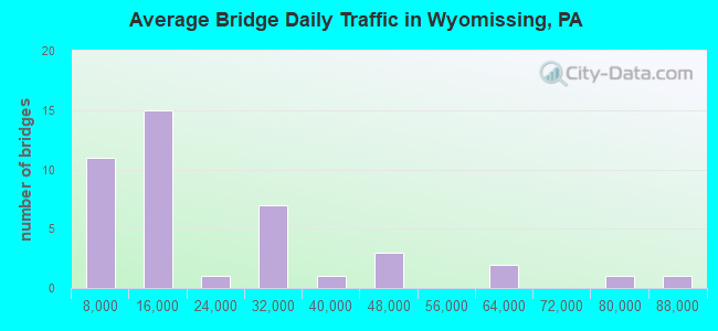
- 894,650Total average daily traffic
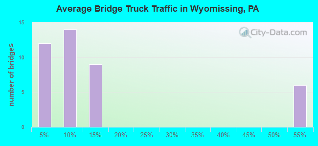
- 107,200Total average daily truck traffic
- National Bridge Inventory (NBI) Registered Bridges for Wyomissing
- No street view available for this location
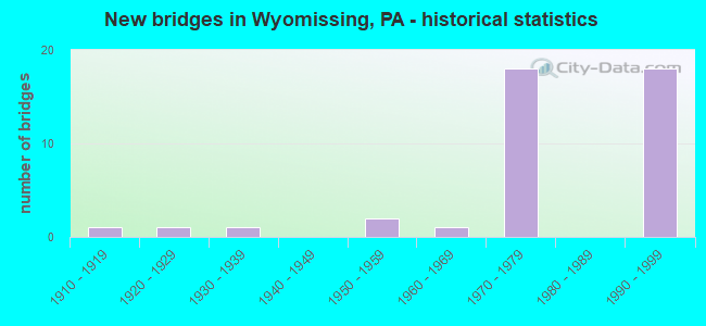
- New bridges - historical statistics
- 11910-1919
- 11920-1929
- 11930-1939
- 21950-1959
- 11960-1969
- 181970-1979
- 181990-1999
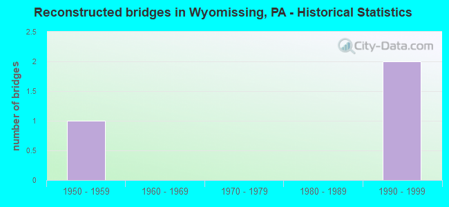
- Reconstructed bridges - Historical Statistics
- 11950-1959
- 01960-1969
- 01970-1979
- 01980-1989
- 21990-1999
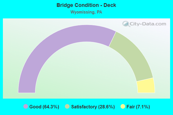
- Bridge Condition - Deck
- 64.3%Good
- 28.6%Satisfactory
- 7.1%Fair
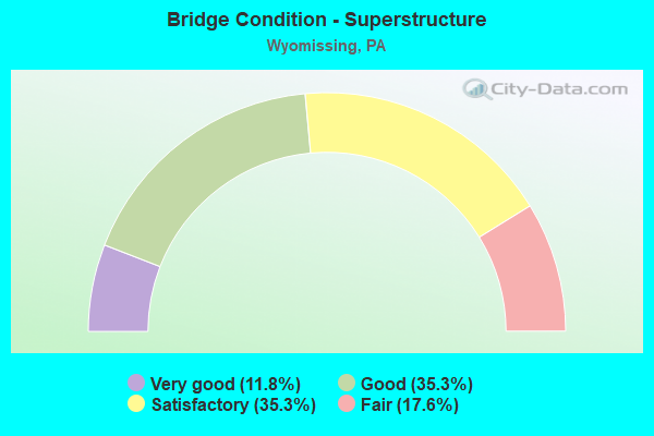
- Bridge Condition - Superstructure
- 11.8%Very good
- 35.3%Good
- 35.3%Satisfactory
- 17.6%Fair
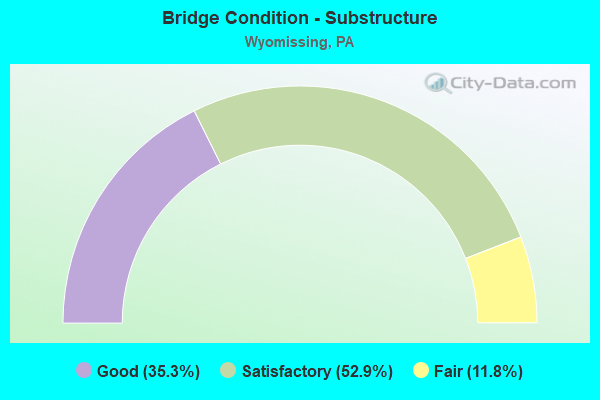
- Bridge Condition - Substructure
- 35.3%Good
- 52.9%Satisfactory
- 11.8%Fair
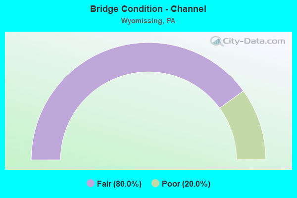
- Bridge Condition - Channel
- 80.0%Fair
- 20.0%Poor
Find on map >> Show street view
Structure Number: 551, Location: OVER OAKDALE ROAD (Lat: 40.436683, Lng: -80.210425), Route carried "on" structure: US 22, Year Built: 1964, Year Reconstructed: 2003, Status: Open, Structure Length: 5.06m (16.60ft), Average Daily Traffic: 24,300 (year 2021), Truck Traffic: 13%, Average Future Daily Traffic: 24,650 (year 2032), Design Load: HS 20, Features Intersected: OAKDALE ROAD SR 3063
Minimum Vertical Clearance: 30+ m (98+ ft), Kilometerpoint: 7.178, Lanes on structure: 5, Lanes under structure: 2, Base Highway Network: Yes, Owner: State Highway Agency, Approaching Roadway Width: 12.5m (41.0ft), Skew: 24 degrees, Material/Design: Steel, Design/Construction: Stringer/Multi-beam, Number Of Spans In Main Unit: 3, Length of Maximum Span: 21.3m (69.9ft), Curb or Sidewalk Widths: Left: 0.2m (0.7ft), Right: 0.2m (0.7ft), Curb-To-Curb Width: 12.5m (41.0ft), Out-to-Out Width: 29.0m (95.1ft)
Condition: Deck: Good, Superstructure: Good, Substructure: Good, Operating Rating: 88.0 metric tons, Method Used To Determine Operating Rating: Load Factor (LF), Inventory Rating: 52.6 metric tons, Method Used To Determine Inventory Rating: Load Factor (LF), Structural Evaluation: Better than present minimum criteria, Deck Geometry: High priority of replacement, Underclear: Somewhat better than minimum adequacy, Approach Roadway Alignment: Equal to present desirable criteria, Length Of Structure Improvement: 5.10m (16.73ft), Designated Inspection Frequency: Every 24 months, Inspection Date: October 2020, Deck Structure Type: Concrete Cast-file-Place, Wearing Surface/Protective System: Wearing Surface: Monolithic Concrete, Deck Protection: Epoxy Coated Reinforcing
Find on map >> Show street view
Structure Number: 4768, Location: LANCASTER PIKE (Lat: 40.305972, Lng: -75.976472), Route carried "on" structure: Business State highway 724, Year Built: 1973, Status: Open, Structure Length: 1.55m (5.09ft), Average Daily Traffic: 11,916 (year 2020), Truck Traffic: 5%, Average Future Daily Traffic: 20,270 (year 2032), Design Load: HS 20, Features Intersected: WYOMISSING CREEK
Minimum Vertical Clearance: 30+ m (98+ ft), Kilometerpoint: 3.825, Lanes on structure: 4, Base Highway Network: Yes, Owner: State Highway Agency, Approaching Roadway Width: 24.1m (79.1ft), Skew: 1 degrees, Material/Design: Prestressed concrete, Design/Construction: Box Beam or Girders - Multiple, Number Of Spans In Main Unit: 1, Length of Maximum Span: 14.9m (48.9ft), Curb or Sidewalk Widths: Left: 1.5m (4.9ft), Right: 1.5m (4.9ft), Curb-To-Curb Width: 24.4m (80.1ft), Out-to-Out Width: 28.4m (93.2ft)
Condition: Deck: Good, Superstructure: Satisfactory, Substructure: Satisfactory, Channel: Fair, Operating Rating: 67.1 metric tons, Method Used To Determine Operating Rating: Load Factor (LF), Inventory Rating: 35.4 metric tons, Method Used To Determine Inventory Rating: Load Factor (LF), Structural Evaluation: Equal to present minimum criteria, Deck Geometry: Superior to present desirable criteria, Waterway Adequacy: Equal to present desirable criteria, Approach Roadway Alignment: Equal to present desirable criteria, Length Of Structure Improvement: 2.20m (7.22ft), Designated Inspection Frequency: Every 24 months, Inspection Date: October 2019, Bridge Improvement Cost: $25,000, Roadway Improvement Cost: $75,000, Total Project Cost: $342,000, Deck Structure Type: Concrete Cast-file-Place, Wearing Surface/Protective System: Wearing Surface: Latex Concrete
Find on map >> Show street view
Structure Number: 4839, Location: INTERSECTION PENN AVE (Lat: 40.327922, Lng: -75.983517), Route carried "on" structure: Business US 422, Year Built: 1977, Status: Open, Structure Length: 9.66m (31.69ft), Average Daily Traffic: 20,411 (year 2022), Truck Traffic: 9%, Average Future Daily Traffic: 14,849 (year 2032), Design Load: HS 20, Features Intersected: LR 06150,NORF/SOUTH
Minimum Vertical Clearance: 30+ m (98+ ft), Kilometerpoint: 24.644, Lanes on structure: 4, Lanes under structure: 4, Base Highway Network: Yes, Owner: State Highway Agency, Approaching Roadway Width: 17.7m (58.1ft), Skew: 36 degrees, Material/Design: Steel, Design/Construction: Stringer/Multi-beam, Number Of Spans In Main Unit: 2, Length of Maximum Span: 50.3m (165.0ft), Curb or Sidewalk Widths: Left: 1.5m (4.9ft), Right: 0.0m, Curb-To-Curb Width: 17.1m (56.1ft), Out-to-Out Width: 18.9m (62.0ft)
Condition: Deck: Good, Superstructure: Satisfactory, Substructure: Satisfactory, Operating Rating: 88.0 metric tons, Method Used To Determine Operating Rating: Load Factor (LF), Inventory Rating: 52.6 metric tons, Method Used To Determine Inventory Rating: Load Factor (LF), Structural Evaluation: Equal to present minimum criteria, Deck Geometry: Somewhat better than minimum adequacy, Underclear: Equal to present minimum criteria, Approach Roadway Alignment: Equal to present desirable criteria, Length Of Structure Improvement: 10.70m (35.10ft), Designated Inspection Frequency: Every 48 months, Inspection Date: Febuary 2019, Deck Structure Type: Concrete Cast-file-Place, Wearing Surface/Protective System: Wearing Surface: Monolithic Concrete
Find on map >> Show street view
Structure Number: 4842, Location: WYOMISSING HILLS (Lat: 40.328306, Lng: -75.978686), Route carried "on" structure: US 222, Year Built: 1977, Status: Open, Structure Length: 15.85m (52.00ft), Average Daily Traffic: 61,350 (year 2022), Truck Traffic: 9%, Average Future Daily Traffic: 80,388 (year 2032), Design Load: HS 20, Features Intersected: SR 3422,SR 8028,NORFKSOU
Minimum Vertical Clearance: 30+ m (98+ ft), Kilometerpoint: 11.319, Lanes on structure: 4, Lanes under structure: 6, Base Highway Network: Yes, Owner: State Highway Agency, Approaching Roadway Width: 30.5m (100.1ft), Skew: 36 degrees, Material/Design: Steel continuous, Design/Construction: Stringer/Multi-beam, Number Of Spans In Main Unit: 3, Length of Maximum Span: 59.7m (195.9ft), Curb-To-Curb Width: 28.8m (94.5ft), Out-to-Out Width: 30.6m (100.4ft)
Condition: Deck: Satisfactory, Superstructure: Good, Substructure: Satisfactory, Operating Rating: 39.0 metric tons, Method Used To Determine Operating Rating: Load and Resistance Factor (LRFR), Inventory Rating: 29.9 metric tons, Method Used To Determine Inventory Rating: Load and Resistance Factor (LRFR), Structural Evaluation: Equal to present minimum criteria, Deck Geometry: Superior to present desirable criteria, Underclear: High priority of corrective action, Approach Roadway Alignment: Better than present minimum criteria, Length Of Structure Improvement: 16.70m (54.79ft), Designated Inspection Frequency: Every 24 months, Inspection Date: December 2020, Deck Structure Type: Concrete Cast-file-Place, Wearing Surface/Protective System: Wearing Surface: Monolithic Concrete
Find on map >> Show street view
Structure Number: 4846, Location: OVER STATE HILL ROAD (Lat: 40.337183, Lng: -75.967097), Route carried "on" structure: US 222, Year Built: 1977, Status: Open, Structure Length: 4.08m (13.39ft), Average Daily Traffic: 76,845 (year 2022), Truck Traffic: 8%, Average Future Daily Traffic: 89,442 (year 2032), Design Load: HS 20, Features Intersected: SR 3023(STATE HILL RD.)
Minimum Vertical Clearance: 30+ m (98+ ft), Kilometerpoint: 12.817, Lanes on structure: 8, Lanes under structure: 10, Base Highway Network: Yes, Owner: State Highway Agency, Approaching Roadway Width: 33.5m (109.9ft), Skew: 33 degrees, Material/Design: Steel, Design/Construction: Stringer/Multi-beam, Number Of Spans In Main Unit: 1, Length of Maximum Span: 40.2m (131.9ft), Curb-To-Curb Width: 40.2m (131.9ft), Out-to-Out Width: 44.0m (144.4ft)
Condition: Deck: Satisfactory, Superstructure: Satisfactory, Substructure: Satisfactory, Inventory Rating: 62.6 metric tons, Method Used To Determine Inventory Rating: Load Factor (LF), Structural Evaluation: Equal to present minimum criteria, Deck Geometry: Superior to present desirable criteria, Underclear: High priority of corrective action, Approach Roadway Alignment: Equal to present desirable criteria, Length Of Structure Improvement: 4.90m (16.08ft), Designated Inspection Frequency: Every 48 months, Inspection Date: August 2018, Deck Structure Type: Concrete Cast-file-Place, Wearing Surface/Protective System: Wearing Surface: Monolithic Concrete
Find on map >> Show street view
Structure Number: 485, Location: 222 OVER CROSSING DRIVE (Lat: 40.346292, Lng: -75.964717), Route carried "on" structure: US 222, Year Built: 1977, Status: Open, Structure Length: 3.20m (10.50ft), Average Daily Traffic: 86,810 (year 2022), Truck Traffic: 7%, Average Future Daily Traffic: 99,601 (year 2032), Design Load: HS 20, Features Intersected: CROSSING DRIVE
Minimum Vertical Clearance: 30+ m (98+ ft), Kilometerpoint: 13.914, Lanes on structure: 5, Lanes under structure: 2, Base Highway Network: Yes, Owner: State Highway Agency, Approaching Roadway Width: 39.6m (129.9ft), Skew: 30 degrees, Material/Design: Steel, Design/Construction: Stringer/Multi-beam, Number Of Spans In Main Unit: 1, Length of Maximum Span: 30.5m (100.1ft), Curb-To-Curb Width: 37.8m (124.0ft), Out-to-Out Width: 39.6m (129.9ft)
Condition: Deck: Satisfactory, Superstructure: Fair, Substructure: Satisfactory, Inventory Rating: 64.4 metric tons, Method Used To Determine Inventory Rating: Load Factor (LF), Structural Evaluation: Somewhat better than minimum adequacy, Deck Geometry: Superior to present desirable criteria, Underclear: Somewhat better than minimum adequacy, Approach Roadway Alignment: Equal to present desirable criteria, Length Of Structure Improvement: 4.00m (13.12ft), Designated Inspection Frequency: Every 24 months, Inspection Date: July 2020, Deck Structure Type: Concrete Cast-file-Place, Wearing Surface/Protective System: Wearing Surface: Monolithic Concrete
Find on map >> Show street view
Structure Number: 5159, Location: PARK ROAD (Lat: 40.338797, Lng: -75.956900), Route carried "on" structure: State highway , Year Built: 1925, Year Reconstructed: 2004, Status: Open, Structure Length: 5.49m (18.01ft), Average Daily Traffic: 14,609 (year 2022), Truck Traffic: 3%, Average Future Daily Traffic: 20,293 (year 2032), Features Intersected: NORFOLK SOUTHERN RR, Facility Carried by Structure: SR 3019 (LR 06070)
Minimum Vertical Clearance: 30+ m (98+ ft), Kilometerpoint: 0.000, Lanes on structure: 2, Owner: Railroad, Maintenance Responsibility: State Highway Agency, Approaching Roadway Width: 9.1m (29.9ft), Material/Design: Concrete, Design/Construction: Arch - Deck, Number Of Spans In Main Unit: 2, Number Of Approach Spans: 1, Length of Maximum Span: 26.2m (86.0ft), Curb or Sidewalk Widths: Left: 2.8m (9.2ft), Right: 2.8m (9.2ft), Curb-To-Curb Width: 9.1m (29.9ft), Out-to-Out Width: 15.4m (50.5ft)
Condition: Superstructure: Satisfactory, Substructure: Satisfactory, Culverts: Satisfactory, Operating Rating: 89.8 metric tons, Method Used To Determine Operating Rating: Allowable Stress (AS), Inventory Rating: 61.7 metric tons, Method Used To Determine Inventory Rating: Allowable Stress (AS), Structural Evaluation: Equal to present minimum criteria, Deck Geometry: High priority of corrective action, Underclear: High priority of corrective action, Approach Roadway Alignment: Somewhat better than minimum adequacy, Length Of Structure Improvement: 6.40m (21.00ft), Designated Inspection Frequency: Every 24 months, Inspection Date: December 2020, Bridge Improvement Cost: $100,000, Roadway Improvement Cost: $294,000, Total Project Cost: $1,347,000, Deck Structure Type: Concrete Cast-file-Place, Wearing Surface/Protective System: Wearing Surface: Bituminous
Find on map >> Show street view
Structure Number: 5172, Location: INTERSECTION READINGBLV (Lat: 40.328222, Lng: -75.979036), Route carried "on" structure: US 222, Year Built: 1977, Status: Open, Structure Length: 6.43m (21.10ft), Average Daily Traffic: 57,868 (year 2022), Truck Traffic: 5%, Average Future Daily Traffic: 68,445 (year 2032), Design Load: HS 20, Features Intersected: T-566,READING BLVD.
Minimum Vertical Clearance: 30+ m (98+ ft), Kilometerpoint: 10.589, Lanes on structure: 4, Lanes under structure: 2, Base Highway Network: Yes, Owner: State Highway Agency, Approaching Roadway Width: 30.5m (100.1ft), Skew: 34 degrees, Material/Design: Steel, Design/Construction: Stringer/Multi-beam, Number Of Spans In Main Unit: 1, Number Of Approach Spans: 2, Length of Maximum Span: 33.2m (108.9ft), Curb-To-Curb Width: 29.0m (95.1ft), Out-to-Out Width: 30.2m (99.1ft)
Condition: Deck: Satisfactory, Superstructure: Satisfactory, Substructure: Satisfactory, Operating Rating: 61.7 metric tons, Method Used To Determine Operating Rating: Load Factor (LF), Inventory Rating: 36.3 metric tons, Method Used To Determine Inventory Rating: Load Factor (LF), Structural Evaluation: Equal to present minimum criteria, Deck Geometry: Superior to present desirable criteria, Underclear: Equal to present minimum criteria, Approach Roadway Alignment: Equal to present desirable criteria, Length Of Structure Improvement: 7.40m (24.28ft), Designated Inspection Frequency: Every 48 months, Inspection Date: December 2019, Deck Structure Type: Concrete Cast-file-Place, Wearing Surface/Protective System: Wearing Surface: Monolithic Concrete
Find on map >> Show street view
Structure Number: 5509, Location: AT WYOMISSING POOL (Lat: 40.322544, Lng: -75.967344), Route carried "on" structure: City street , Year Built: 1959, Status: Open, Structure Length: 1.86m (6.10ft), Average Daily Traffic: 2,000 (year 2010), Truck Traffic: 3%, Average Future Daily Traffic: 2,200 (year 2020), Design Load: H 20, Features Intersected: WYOMISSING CREEK, Facility Carried by Structure: OLD MILL ROAD
Minimum Vertical Clearance: 30+ m (98+ ft), Kilometerpoint: 0.000, Lanes on structure: 2, Owner: City or Municipal Highway Agency, Approaching Roadway Width: 11.3m (37.1ft), Skew: 1 degrees, Material/Design: Prestressed concrete, Design/Construction: Box Beam or Girders - Multiple, Number Of Spans In Main Unit: 1, Length of Maximum Span: 17.4m (57.1ft), Curb or Sidewalk Widths: Left: 2.8m (9.2ft), Right: 2.8m (9.2ft), Curb-To-Curb Width: 12.2m (40.0ft), Out-to-Out Width: 18.3m (60.0ft)
Condition: Deck: Fair, Superstructure: Fair, Substructure: Satisfactory, Channel: Fair, Operating Rating: 45.4 metric tons, Method Used To Determine Operating Rating: Load Factor (LF), Inventory Rating: 27.2 metric tons, Method Used To Determine Inventory Rating: Load Factor (LF), Structural Evaluation: Somewhat better than minimum adequacy, Deck Geometry: Better than present minimum criteria, Waterway Adequacy: Better than present minimum criteria, Approach Roadway Alignment: Equal to present desirable criteria, Length Of Structure Improvement: 2.50m (8.20ft), Designated Inspection Frequency: Every 24 months, Inspection Date: October 2021, Deck Structure Type: Other, Wearing Surface/Protective System: Wearing Surface: Bituminous
Find on map >> Show street view
Structure Number: 551, Location: WYOMISSING HS & POOL (Lat: 40.322231, Lng: -75.969522), Route carried "on" structure: City street , Year Built: 1959, Status: Open, Structure Length: 0.76m (2.49ft), Average Daily Traffic: 2,000 (year 2010), Truck Traffic: 3%, Average Future Daily Traffic: 2,200 (year 2020), Design Load: H 20, Features Intersected: WYOMISSING CREEK, Facility Carried by Structure: OLD MILL RD
Minimum Vertical Clearance: 30+ m (98+ ft), Kilometerpoint: 0.000, Lanes on structure: 2, Owner: City or Municipal Highway Agency, Approaching Roadway Width: 11.0m (36.1ft), Skew: 1 degrees, Material/Design: Concrete, Design/Construction: Culvert, Number Of Spans In Main Unit: 1, Length of Maximum Span: 7.6m (24.9ft), Curb-To-Curb Width: 11.0m (36.1ft), Out-to-Out Width: 18.3m (60.0ft)
Condition: Channel: Fair, Culverts: Satisfactory, Operating Rating: 54.4 metric tons, Method Used To Determine Operating Rating: Field evaluation and documented engineering judgment, Inventory Rating: 32.7 metric tons, Method Used To Determine Inventory Rating: Field evaluation and documented engineering judgment, Structural Evaluation: Equal to present minimum criteria, Deck Geometry: Equal to present minimum criteria, Waterway Adequacy: Better than present minimum criteria, Approach Roadway Alignment: Equal to present desirable criteria, Length Of Structure Improvement: 1.40m (4.59ft), Designated Inspection Frequency: Every 24 months, Inspection Date: October 2021, Wearing Surface/Protective System: Wearing Surface: Bituminous
Find on map >> Show street view
Structure Number: 5511, Location: RUTH'S BRIDGE (Lat: 40.315850, Lng: -75.968508), Route carried "on" structure: City street , Year Built: 1910, Year Reconstructed: 1963, Status: Posted for load, Structure Length: 1.98m (6.50ft), Average Daily Traffic: 215 (year 2017), Average Future Daily Traffic: 286 (year 2033), Features Intersected: WYOMISSING CREEK, Facility Carried by Structure: OLD WYOMISSING RD.
Minimum Vertical Clearance: 30+ m (98+ ft), Kilometerpoint: 0.000, Lanes on structure: 2, Owner: County Highway Agency, Approaching Roadway Width: 4.6m (15.1ft), Skew: 1 degrees, Material/Design: Concrete, Design/Construction: Arch - Deck, Number Of Spans In Main Unit: 1, Length of Maximum Span: 19.8m (65.0ft), Curb-To-Curb Width: 6.1m (20.0ft), Out-to-Out Width: 6.8m (22.3ft)
Condition: Superstructure: Satisfactory, Substructure: Fair, Channel: Fair, Operating Rating: 61.7 metric tons, Method Used To Determine Operating Rating: Field evaluation and documented engineering judgment, Inventory Rating: 36.3 metric tons, Method Used To Determine Inventory Rating: Field evaluation and documented engineering judgment, Structural Evaluation: Somewhat better than minimum adequacy, Deck Geometry: Meets minimum limits, Waterway Adequacy: Equal to present minimum criteria, Approach Roadway Alignment: Equal to present desirable criteria, Length Of Structure Improvement: 2.70m (8.86ft), Designated Inspection Frequency: Every 24 months, Other Special Inspection Frequency: Every 12 months, Inspection Date: June 2020, Other Special Inspection Date: June 2021, Bridge Improvement Cost: $12,000, Roadway Improvement Cost: $34,000, Total Project Cost: $156,000
Find on map >> Show street view
Structure Number: 5512, Location: BORO OF WYOMISSING (Lat: 40.325319, Lng: -75.960644), Route carried "on" structure: City street , Year Built: 1931, Status: Open, Structure Length: 1.52m (4.99ft), Average Daily Traffic: 11,125 (year 2016), Truck Traffic: 2%, Average Future Daily Traffic: 11,491 (year 2021), Features Intersected: WYOMISSING CREEK, Facility Carried by Structure: WYOMISSING BLVD
Minimum Vertical Clearance: 30+ m (98+ ft), Kilometerpoint: 0.000, Lanes on structure: 4, Owner: County Highway Agency, Approaching Roadway Width: 21.9m (71.9ft), Skew: 30 degrees, Material/Design: Concrete, Design/Construction: Arch - Deck, Number Of Spans In Main Unit: 1, Length of Maximum Span: 15.2m (49.9ft), Curb or Sidewalk Widths: Left: 3.9m (12.8ft), Right: 3.9m (12.8ft), Curb-To-Curb Width: 13.4m (44.0ft), Out-to-Out Width: 30.5m (100.1ft)
Condition: Superstructure: Fair, Substructure: Fair, Channel: Poor, Inventory Rating: 89.8 metric tons, Method Used To Determine Inventory Rating: Load Factor (LF), Structural Evaluation: Somewhat better than minimum adequacy, Deck Geometry: High priority of replacement, Waterway Adequacy: Equal to present minimum criteria, Approach Roadway Alignment: Equal to present desirable criteria, Length Of Structure Improvement: 2.30m (7.55ft), Designated Inspection Frequency: Every 24 months, Inspection Date: June 2021, Bridge Improvement Cost: $32,000, Roadway Improvement Cost: $95,000, Total Project Cost: $437,000
Find on map >> Show street view
Structure Number: 39658, Location: BERKSHIRE BLVD. (Lat: 40.352883, Lng: -75.965631), Route carried "on" structure: State highway , Year Built: 1997, Status: Open, Structure Length: 7.59m (24.90ft), Average Daily Traffic: 1,373 (year 2021), Truck Traffic: 1%, Average Future Daily Traffic: 1,993 (year 2032), Design Load: HS 25 or greater, Features Intersected: SR 0222; RAMP I & J, Facility Carried by Structure: SR3044(BERKSHIRE)
Minimum Vertical Clearance: 30+ m (98+ ft), Kilometerpoint: 0.000, Lanes on structure: 2, Lanes under structure: 18, Owner: State Highway Agency, Approaching Roadway Width: 12.2m (40.0ft), Skew: 1 degrees, Material/Design: Prestressed concrete, Design/Construction: Box Beam or Girders - Single/Spread, Number Of Spans In Main Unit: 3, Length of Maximum Span: 27.7m (90.9ft), Curb or Sidewalk Widths: Left: 1.5m (4.9ft), Right: 1.5m (4.9ft), Curb-To-Curb Width: 12.2m (40.0ft), Out-to-Out Width: 15.8m (51.8ft)
Condition: Deck: Good, Superstructure: Good, Substructure: Good, Inventory Rating: 55.3 metric tons, Method Used To Determine Inventory Rating: Load Factor (LF), Structural Evaluation: Better than present minimum criteria, Deck Geometry: Better than present minimum criteria, Underclear: Equal to present minimum criteria, Approach Roadway Alignment: Equal to present desirable criteria, Length Of Structure Improvement: 8.60m (28.22ft), Designated Inspection Frequency: Every 48 months, Inspection Date: October 2019, Deck Structure Type: Concrete Cast-file-Place, Wearing Surface/Protective System: Wearing Surface: Monolithic Concrete, Deck Protection: Epoxy Coated Reinforcing
Find on map >> Show street view
Structure Number: 40023, Location: N.WYOMISSING BLVD.OVER422 (Lat: 40.344164, Lng: -75.952072), Route carried "on" structure: State highway , Year Built: 1998, Status: Open, Structure Length: 2.74m (8.99ft), Average Daily Traffic: 14,609 (year 2022), Truck Traffic: 3%, Average Future Daily Traffic: 20,293 (year 2032), Design Load: HS 25 or greater, Features Intersected: US 422, Facility Carried by Structure: N. WYOMISSING BLVD
Minimum Vertical Clearance: 30+ m (98+ ft), Kilometerpoint: 1.255, Lanes on structure: 2, Lanes under structure: 4, Owner: State Highway Agency, Approaching Roadway Width: 11.0m (36.1ft), Material/Design: Prestressed concrete, Design/Construction: Box Beam or Girders - Single/Spread, Number Of Spans In Main Unit: 1, Length of Maximum Span: 26.5m (86.9ft), Curb or Sidewalk Widths: Left: 0.5m (1.6ft), Right: 0.5m (1.6ft), Curb-To-Curb Width: 11.0m (36.1ft), Out-to-Out Width: 12.0m (39.4ft)
Condition: Deck: Good, Superstructure: Good, Substructure: Good, Operating Rating: 89.8 metric tons, Method Used To Determine Operating Rating: Load Factor (LF), Inventory Rating: 43.5 metric tons, Method Used To Determine Inventory Rating: Load Factor (LF), Structural Evaluation: Better than present minimum criteria, Deck Geometry: Meets minimum limits, Underclear: High priority of corrective action, Approach Roadway Alignment: Equal to present desirable criteria, Length Of Structure Improvement: 3.50m (11.48ft), Designated Inspection Frequency: Every 48 months, Inspection Date: May 2020, Deck Structure Type: Concrete Cast-file-Place, Wearing Surface/Protective System: Wearing Surface: Monolithic Concrete, Deck Protection: Epoxy Coated Reinforcing
Find on map >> Show street view
Structure Number: 40234, Location: RAMP K OVER US 222 (Lat: 40.352747, Lng: -75.962558), Route carried "on" structure: Ramp State highway , Year Built: 1998, Status: Open, Structure Length: 5.33m (17.49ft), Average Daily Traffic: 10,167 (year 2022), Truck Traffic: 50%, Average Future Daily Traffic: 14,924 (year 2032), Design Load: HS 25 or greater, Features Intersected: US 222, Facility Carried by Structure: RAMP K(SR 8042)
Minimum Vertical Clearance: 30+ m (98+ ft), Kilometerpoint: 0.000, Lanes on structure: 1, Lanes under structure: 8, Base Highway Network: Yes, Owner: State Highway Agency, Approaching Roadway Width: 9.8m (32.2ft), Skew: 3 degrees, Material/Design: Steel continuous, Design/Construction: Stringer/Multi-beam, Number Of Spans In Main Unit: 2, Length of Maximum Span: 28.3m (92.8ft), Curb or Sidewalk Widths: Left: 0.3m (1.0ft), Right: 0.3m (1.0ft), Curb-To-Curb Width: 9.8m (32.2ft), Out-to-Out Width: 10.9m (35.8ft)
Condition: Deck: Good, Superstructure: Very good, Substructure: Good, Operating Rating: 68.0 metric tons, Method Used To Determine Operating Rating: Load Factor (LF), Inventory Rating: 40.8 metric tons, Method Used To Determine Inventory Rating: Load Factor (LF), Structural Evaluation: Better than present minimum criteria, Deck Geometry: Superior to present desirable criteria, Underclear: Equal to present minimum criteria, Approach Roadway Alignment: Equal to present minimum criteria, Length Of Structure Improvement: 6.30m (20.67ft), Designated Inspection Frequency: Every 48 months, Inspection Date: August 2018, Deck Structure Type: Concrete Cast-file-Place, Wearing Surface/Protective System: Wearing Surface: Monolithic Concrete, Deck Protection: Epoxy Coated Reinforcing
Find on map >> Show street view
Structure Number: 40492, Location: RAMP J OVER WARREN ST. (Lat: 40.348753, Lng: -75.961886), Route carried "on" structure: Ramp State highway , Year Built: 1999, Status: Open, Structure Length: 3.75m (12.30ft), Average Daily Traffic: 14,874 (year 2022), Truck Traffic: 50%, Average Future Daily Traffic: 15,529 (year 2032), Design Load: HS 25 or greater, Features Intersected: US 222, Facility Carried by Structure: RAMP J(SR 8042)
Minimum Vertical Clearance: 30+ m (98+ ft), Kilometerpoint: 0.000, Lanes on structure: 1, Lanes under structure: 8, Base Highway Network: Yes, Owner: State Highway Agency, Approaching Roadway Width: 9.8m (32.2ft), Skew: 3 degrees, Material/Design: Prestressed concrete, Design/Construction: Stringer/Multi-beam, Number Of Spans In Main Unit: 2, Length of Maximum Span: 19.8m (65.0ft), Curb or Sidewalk Widths: Left: 0.2m (0.7ft), Right: 0.2m (0.7ft), Curb-To-Curb Width: 9.8m (32.2ft), Out-to-Out Width: 10.8m (35.4ft)
Condition: Deck: Good, Superstructure: Good, Substructure: Satisfactory, Operating Rating: 86.2 metric tons, Method Used To Determine Operating Rating: Load Factor (LF), Inventory Rating: 44.5 metric tons, Method Used To Determine Inventory Rating: Load Factor (LF), Structural Evaluation: Equal to present minimum criteria, Deck Geometry: Superior to present desirable criteria, Underclear: Superior to present desirable criteria, Approach Roadway Alignment: Better than present minimum criteria, Length Of Structure Improvement: 4.70m (15.42ft), Designated Inspection Frequency: Every 48 months, Inspection Date: June 2019, Deck Structure Type: Concrete Cast-file-Place, Wearing Surface/Protective System: Wearing Surface: Monolithic Concrete, Deck Protection: Epoxy Coated Reinforcing
Find on map >> Show street view
Structure Number: 40493, Location: RAMP J OVER RAMP K (Lat: 40.352078, Lng: -75.964081), Route carried "on" structure: Ramp State highway , Year Built: 1998, Status: Open, Structure Length: 3.29m (10.79ft), Average Daily Traffic: 14,874 (year 2022), Truck Traffic: 50%, Average Future Daily Traffic: 15,529 (year 2032), Design Load: HS 25 or greater, Features Intersected: SR 8042;RAMP K, Facility Carried by Structure: RAMP J
Minimum Vertical Clearance: 30+ m (98+ ft), Kilometerpoint: 0.000, Lanes on structure: 1, Lanes under structure: 1, Base Highway Network: Yes, Owner: State Highway Agency, Approaching Roadway Width: 9.8m (32.2ft), Skew: 4 degrees, Material/Design: Prestressed concrete, Design/Construction: Stringer/Multi-beam, Number Of Spans In Main Unit: 1, Length of Maximum Span: 31.7m (104.0ft), Curb or Sidewalk Widths: Left: 0.2m (0.7ft), Right: 0.2m (0.7ft), Curb-To-Curb Width: 9.8m (32.2ft), Out-to-Out Width: 10.8m (35.4ft)
Condition: Deck: Good, Superstructure: Very good, Substructure: Good, Operating Rating: 89.8 metric tons, Method Used To Determine Operating Rating: Load Factor (LF), Inventory Rating: 59.0 metric tons, Method Used To Determine Inventory Rating: Load Factor (LF), Structural Evaluation: Better than present minimum criteria, Deck Geometry: Superior to present desirable criteria, Underclear: Superior to present desirable criteria, Approach Roadway Alignment: Equal to present desirable criteria, Length Of Structure Improvement: 4.10m (13.45ft), Designated Inspection Frequency: Every 48 months, Inspection Date: August 2019, Deck Structure Type: Concrete Cast-file-Place, Wearing Surface/Protective System: Wearing Surface: Monolithic Concrete, Deck Protection: Epoxy Coated Reinforcing
Find on map >> Show street view
Structure Number: 40494, Location: RAMP J OVER US 222 (Lat: 40.352883, Lng: -75.964967), Route carried "on" structure: Ramp State highway , Year Built: 1998, Status: Open, Structure Length: 8.50m (27.89ft), Average Daily Traffic: 14,874 (year 2022), Truck Traffic: 50%, Average Future Daily Traffic: 15,529 (year 2032), Design Load: HS 25 or greater, Features Intersected: US 222, Facility Carried by Structure: RAMP J(SR8042)
Minimum Vertical Clearance: 30+ m (98+ ft), Kilometerpoint: 0.000, Lanes on structure: 1, Lanes under structure: 8, Base Highway Network: Yes, Owner: State Highway Agency, Approaching Roadway Width: 9.8m (32.2ft), Skew: 4 degrees, Material/Design: Steel continuous, Design/Construction: Stringer/Multi-beam, Number Of Spans In Main Unit: 2, Length of Maximum Span: 45.4m (149.0ft), Curb or Sidewalk Widths: Left: 0.3m (1.0ft), Right: 0.3m (1.0ft), Curb-To-Curb Width: 9.8m (32.2ft), Out-to-Out Width: 10.8m (35.4ft)
Condition: Deck: Good, Superstructure: Good, Substructure: Good, Operating Rating: 68.0 metric tons, Method Used To Determine Operating Rating: Assigned rating based on Load Factor Design (LFD) reported in metric tons, Inventory Rating: 40.8 metric tons, Method Used To Determine Inventory Rating: Assigned rating based on Load Factor Design (LFD) reported in metric tons, Structural Evaluation: Better than present minimum criteria, Deck Geometry: Superior to present desirable criteria, Underclear: Superior to present desirable criteria, Approach Roadway Alignment: Better than present minimum criteria, Length Of Structure Improvement: 9.40m (30.84ft), Designated Inspection Frequency: Every 48 months, Inspection Date: August 2021, Deck Structure Type: Concrete Cast-file-Place, Wearing Surface/Protective System: Wearing Surface: Monolithic Concrete, Deck Protection: Epoxy Coated Reinforcing
Find on map >> Show street view
Structure Number: 4839, Location: INTERSECTION PENN AVE (Lat: 40.327922, Lng: -75.983517), Route carried "under" structure: Spur State highway , Year Built: 1977, Structure Length: 0. m, Average Daily Traffic: 8,041 (year 2022), Truck Traffic: 7%, Features Intersected: LR 06150,NORF/SOUTH, Facility Carried by Structure: US422BUS (LR 149)
Minimum Vertical Clearance: 6.37m (20.90ft), Kilometerpoint: 0.000, Lanes on structure: 4, Lanes under structure: 2, Material/Design: Steel, Design/Construction: Stringer/Multi-beam, Length of Maximum Span: 50.3m (165.0ft)
Find on map >> Show street view
Structure Number: 4839, Location: INTERSECTION PENN AVE (Lat: 40.327922, Lng: -75.983517), Route carried "under" structure: Spur State highway , Year Built: 1977, Structure Length: 0. m, Average Daily Traffic: 7,143 (year 2022), Truck Traffic: 7%, Features Intersected: LR 06150,NORF/SOUTH, Facility Carried by Structure: US422BUS (LR 149)
Minimum Vertical Clearance: 6.37m (20.90ft), Kilometerpoint: 0.000, Lanes on structure: 4, Lanes under structure: 2, Material/Design: Steel, Design/Construction: Stringer/Multi-beam, Length of Maximum Span: 50.3m (165.0ft)
Find on map >> Show street view
Structure Number: 4842, Location: WYOMISSING HILLS (Lat: 40.328306, Lng: -75.978686), Route carried "under" structure: State highway , Year Built: 1977, Structure Length: 0. m, Average Daily Traffic: 7,557 (year 2022), Truck Traffic: 7%, Features Intersected: SR 3422,SR 8028,NORFKSOU, Facility Carried by Structure: SR 222
Minimum Vertical Clearance: 6.31m (20.70ft), Kilometerpoint: 0.000, Lanes on structure: 4, Lanes under structure: 2, Material/Design: Steel continuous, Design/Construction: Stringer/Multi-beam, Length of Maximum Span: 59.7m (195.9ft)
Find on map >> Show street view
Structure Number: 4842, Location: WYOMISSING HILLS (Lat: 40.328306, Lng: -75.978686), Route carried "under" structure: Business US 422B, Year Built: 1977, Structure Length: 0. m, Average Daily Traffic: 4,217 (year 2020), Truck Traffic: 3%, Features Intersected: SR 3422,SR 8028,NORFKSOU, Facility Carried by Structure: SR 222
Minimum Vertical Clearance: 8.00m (26.25ft), Kilometerpoint: 0.000, Lanes on structure: 4, Lanes under structure: 2, Material/Design: Steel continuous, Design/Construction: Stringer/Multi-beam, Length of Maximum Span: 59.7m (195.9ft)
Find on map >> Show street view
Structure Number: 4842, Location: WYOMISSING HILLS (Lat: 40.328306, Lng: -75.978686), Route carried "under" structure: Business US 422B, Year Built: 1977, Structure Length: 0. m, Average Daily Traffic: 4,217 (year 2020), Truck Traffic: 3%, Features Intersected: SR 3422,SR 8028,NORFKSOU, Facility Carried by Structure: SR 222
Minimum Vertical Clearance: 8.80m (28.87ft), Kilometerpoint: 0.000, Lanes on structure: 4, Lanes under structure: 2, Material/Design: Steel continuous, Design/Construction: Stringer/Multi-beam, Length of Maximum Span: 59.7m (195.9ft)
Find on map >> Show street view
Structure Number: 4842, Location: WYOMISSING HILLS (Lat: 40.328306, Lng: -75.978686), Route carried "under" structure: US 422, Year Built: 1977, Structure Length: 0. m, Average Daily Traffic: 10,388 (year 2022), Truck Traffic: 9%, Features Intersected: SR 3422,SR 8028,NORFKSOU, Facility Carried by Structure: SR 222
Minimum Vertical Clearance: 8.81m (28.90ft), Kilometerpoint: 24.644, Lanes on structure: 4, Lanes under structure: 2, Material/Design: Steel continuous, Design/Construction: Stringer/Multi-beam, Length of Maximum Span: 59.7m (195.9ft)
Find on map >> Show street view
Structure Number: 4842, Location: WYOMISSING HILLS (Lat: 40.328306, Lng: -75.978686), Route carried "under" structure: US 422, Year Built: 1977, Structure Length: 0. m, Average Daily Traffic: 10,023 (year 2022), Truck Traffic: 9%, Features Intersected: SR 3422,SR 8028,NORFKSOU, Facility Carried by Structure: SR 222
Minimum Vertical Clearance: 7.99m (26.21ft), Kilometerpoint: 24.644, Lanes on structure: 4, Lanes under structure: 2, Material/Design: Steel continuous, Design/Construction: Stringer/Multi-beam, Length of Maximum Span: 59.7m (195.9ft)
Find on map >> Show street view
Structure Number: 4842, Location: WYOMISSING HILLS (Lat: 40.328306, Lng: -75.978686), Route carried "under" structure: Business State highway , Year Built: 1977, Structure Length: 0. m, Average Daily Traffic: 8,041 (year 2022), Truck Traffic: 7%, Features Intersected: SR 3422,SR 8028,NORFKSOU, Facility Carried by Structure: SR 222
Minimum Vertical Clearance: 6.31m (20.70ft), Kilometerpoint: 0.000, Lanes on structure: 4, Lanes under structure: 2, Material/Design: Steel continuous, Design/Construction: Stringer/Multi-beam, Length of Maximum Span: 59.7m (195.9ft)
Find on map >> Show street view
Structure Number: 4846, Location: OVER STATE HILL ROAD (Lat: 40.337183, Lng: -75.967097), Route carried "under" structure: State highway , Year Built: 1977, Structure Length: 0. m, Average Daily Traffic: 7,838 (year 2021), Truck Traffic: 1%, Features Intersected: SR 3023(STATE HILL RD.), Facility Carried by Structure: US 222 (LR 06150)
Minimum Vertical Clearance: 4.85m (15.91ft), Kilometerpoint: 0.417, Lanes on structure: 8, Lanes under structure: 5, Material/Design: Steel, Design/Construction: Stringer/Multi-beam, Length of Maximum Span: 40.2m (131.9ft)
Find on map >> Show street view
Structure Number: 4846, Location: OVER STATE HILL ROAD (Lat: 40.337183, Lng: -75.967097), Route carried "under" structure: State highway , Year Built: 1977, Structure Length: 0. m, Average Daily Traffic: 10,569 (year 2022), Truck Traffic: 2%, Features Intersected: SR 3023(STATE HILL RD.), Facility Carried by Structure: US 222 (LR 06150)
Minimum Vertical Clearance: 5.09m (16.70ft), Kilometerpoint: 0.404, Lanes on structure: 8, Lanes under structure: 5, Material/Design: Steel, Design/Construction: Stringer/Multi-beam, Length of Maximum Span: 40.2m (131.9ft)
Find on map >> Show street view
Structure Number: 485, Location: 222 OVER CROSSING DRIVE (Lat: 40.346292, Lng: -75.964717), Route carried "under" structure: City street , Year Built: 1977, Structure Length: 0. m, Average Daily Traffic: 1,170 (year 1975), Truck Traffic: 1%, Features Intersected: CROSSING DRIVE, Facility Carried by Structure: US 222 (LR 06150)
Minimum Vertical Clearance: 4.70m (15.42ft), Kilometerpoint: 0.000, Lanes on structure: 5, Lanes under structure: 2, Material/Design: Steel, Design/Construction: Stringer/Multi-beam, Length of Maximum Span: 30.5m (100.1ft)
Find on map >> Show street view
Structure Number: 5172, Location: INTERSECTION READINGBLV (Lat: 40.328222, Lng: -75.979036), Route carried "under" structure: City street , Year Built: 1977, Structure Length: 0. m, Average Daily Traffic: 500 (year 1994), Truck Traffic: 1%, Features Intersected: T-566,READING BLVD., Facility Carried by Structure: SR 222
Minimum Vertical Clearance: 5.15m (16.90ft), Kilometerpoint: 0.000, Lanes on structure: 4, Lanes under structure: 2, Material/Design: Steel, Design/Construction: Stringer/Multi-beam, Length of Maximum Span: 33.2m (108.9ft)
Find on map >> Show street view
Structure Number: 39658, Location: BERKSHIRE BLVD. (Lat: 40.352883, Lng: -75.965631), Route carried "under" structure: Ramp State highway , Year Built: 1997, Structure Length: 0. m, Average Daily Traffic: 14,874 (year 2022), Truck Traffic: 50%, Features Intersected: SR 0222; RAMP I & J, Facility Carried by Structure: SR3044(BERKSHIRE)
Minimum Vertical Clearance: 5.15m (16.90ft), Kilometerpoint: 0.000, Lanes on structure: 2, Lanes under structure: 6, Material/Design: Prestressed concrete, Design/Construction: Box Beam or Girders - Single/Spread, Length of Maximum Span: 27.7m (90.9ft)
Find on map >> Show street view
Structure Number: 39658, Location: BERKSHIRE BLVD. (Lat: 40.352883, Lng: -75.965631), Route carried "under" structure: US 222, Year Built: 1997, Structure Length: 0. m, Average Daily Traffic: 31,275 (year 2022), Truck Traffic: 10%, Features Intersected: SR 0222; RAMP I & J, Facility Carried by Structure: SR3044(BERKSHIRE)
Minimum Vertical Clearance: 7.83m (25.69ft), Kilometerpoint: 14.687, Lanes on structure: 2, Lanes under structure: 6, Material/Design: Prestressed concrete, Design/Construction: Box Beam or Girders - Single/Spread, Length of Maximum Span: 27.7m (90.9ft)
Find on map >> Show street view
Structure Number: 39658, Location: BERKSHIRE BLVD. (Lat: 40.352883, Lng: -75.965631), Route carried "under" structure: US 222, Year Built: 1997, Structure Length: 0. m, Average Daily Traffic: 29,857 (year 2022), Truck Traffic: 11%, Features Intersected: SR 0222; RAMP I & J, Facility Carried by Structure: SR3044(BERKSHIRE)
Minimum Vertical Clearance: 6.95m (22.80ft), Kilometerpoint: 14.677, Lanes on structure: 2, Lanes under structure: 6, Material/Design: Prestressed concrete, Design/Construction: Box Beam or Girders - Single/Spread, Length of Maximum Span: 27.7m (90.9ft)
Find on map >> Show street view
Structure Number: 40023, Location: N.WYOMISSING BLVD.OVER422 (Lat: 40.344164, Lng: -75.952072), Route carried "under" structure: US 422, Year Built: 1998, Structure Length: 0. m, Average Daily Traffic: 39,154 (year 2022), Truck Traffic: 13%, Features Intersected: US 422, Facility Carried by Structure: N. WYOMISSING BLVD
Minimum Vertical Clearance: 5.18m (16.99ft), Kilometerpoint: 26.226, Lanes on structure: 2, Lanes under structure: 2, Material/Design: Prestressed concrete, Design/Construction: Box Beam or Girders - Single/Spread, Length of Maximum Span: 26.5m (86.9ft)
Find on map >> Show street view
Structure Number: 40023, Location: N.WYOMISSING BLVD.OVER422 (Lat: 40.344164, Lng: -75.952072), Route carried "under" structure: US 422, Year Built: 1998, Structure Length: 0. m, Average Daily Traffic: 40,325 (year 2022), Truck Traffic: 12%, Features Intersected: US 422, Facility Carried by Structure: N. WYOMISSING BLVD
Minimum Vertical Clearance: 5.18m (16.99ft), Kilometerpoint: 26.234, Lanes on structure: 2, Lanes under structure: 2, Material/Design: Prestressed concrete, Design/Construction: Box Beam or Girders - Single/Spread, Length of Maximum Span: 26.5m (86.9ft)
Find on map >> Show street view
Structure Number: 40234, Location: RAMP K OVER US 222 (Lat: 40.352747, Lng: -75.962558), Route carried "under" structure: US 222, Year Built: 1998, Structure Length: 0. m, Average Daily Traffic: 31,275 (year 2022), Truck Traffic: 10%, Features Intersected: US 222, Facility Carried by Structure: RAMP K(SR 8042)
Minimum Vertical Clearance: 6.49m (21.29ft), Kilometerpoint: 14.687, Lanes on structure: 1, Lanes under structure: 4, Material/Design: Steel continuous, Design/Construction: Stringer/Multi-beam, Length of Maximum Span: 28.3m (92.8ft)
Find on map >> Show street view
Structure Number: 40234, Location: RAMP K OVER US 222 (Lat: 40.352747, Lng: -75.962558), Route carried "under" structure: US 222, Year Built: 1998, Structure Length: 0. m, Average Daily Traffic: 29,857 (year 2022), Truck Traffic: 11%, Features Intersected: US 222, Facility Carried by Structure: RAMP K(SR 8042)
Minimum Vertical Clearance: 5.70m (18.70ft), Kilometerpoint: 14.677, Lanes on structure: 1, Lanes under structure: 4, Material/Design: Steel continuous, Design/Construction: Stringer/Multi-beam, Length of Maximum Span: 28.3m (92.8ft)
Find on map >> Show street view
Structure Number: 40492, Location: RAMP J OVER WARREN ST. (Lat: 40.348753, Lng: -75.961886), Route carried "under" structure: US 222, Year Built: 1999, Structure Length: 0. m, Average Daily Traffic: 41,168 (year 2022), Truck Traffic: 6%, Features Intersected: US 222, Facility Carried by Structure: RAMP J(SR 8042)
Minimum Vertical Clearance: 5.76m (18.90ft), Kilometerpoint: 13.914, Lanes on structure: 1, Lanes under structure: 4, Material/Design: Prestressed concrete, Design/Construction: Stringer/Multi-beam, Length of Maximum Span: 19.8m (65.0ft)
Find on map >> Show street view
Structure Number: 40492, Location: RAMP J OVER WARREN ST. (Lat: 40.348753, Lng: -75.961886), Route carried "under" structure: US 222, Year Built: 1999, Structure Length: 0. m, Average Daily Traffic: 45,642 (year 2022), Truck Traffic: 8%, Features Intersected: US 222, Facility Carried by Structure: RAMP J(SR 8042)
Minimum Vertical Clearance: 6.64m (21.78ft), Kilometerpoint: 13.903, Lanes on structure: 1, Lanes under structure: 4, Material/Design: Prestressed concrete, Design/Construction: Stringer/Multi-beam, Length of Maximum Span: 19.8m (65.0ft)
Find on map >> Show street view
Structure Number: 40493, Location: RAMP J OVER RAMP K (Lat: 40.352078, Lng: -75.964081), Route carried "under" structure: Ramp State highway , Year Built: 1998, Structure Length: 0. m, Average Daily Traffic: 10,167 (year 2022), Truck Traffic: 50%, Features Intersected: SR 8042;RAMP K, Facility Carried by Structure: RAMP J
Minimum Vertical Clearance: 5.59m (18.34ft), Kilometerpoint: 0.000, Lanes on structure: 1, Lanes under structure: 1, Material/Design: Prestressed concrete, Design/Construction: Stringer/Multi-beam, Length of Maximum Span: 31.7m (104.0ft)
Find on map >> Show street view
Structure Number: 40494, Location: RAMP J OVER US 222 (Lat: 40.352883, Lng: -75.964967), Route carried "under" structure: US 222, Year Built: 1998, Structure Length: 0. m, Average Daily Traffic: 31,275 (year 2022), Truck Traffic: 10%, Features Intersected: US 222, Facility Carried by Structure: RAMP J(SR8042)
Minimum Vertical Clearance: 5.70m (18.70ft), Kilometerpoint: 14.687, Lanes on structure: 1, Lanes under structure: 4, Material/Design: Steel continuous, Design/Construction: Stringer/Multi-beam, Length of Maximum Span: 45.4m (149.0ft)
Find on map >> Show street view
Structure Number: 40494, Location: RAMP J OVER US 222 (Lat: 40.352883, Lng: -75.964967), Route carried "under" structure: US 222, Year Built: 1998, Structure Length: 0. m, Average Daily Traffic: 29,857 (year 2022), Truck Traffic: 11%, Features Intersected: US 222, Facility Carried by Structure: RAMP J(SR8042)
Minimum Vertical Clearance: 6.95m (22.80ft), Kilometerpoint: 14.677, Lanes on structure: 1, Lanes under structure: 4, Material/Design: Steel continuous, Design/Construction: Stringer/Multi-beam, Length of Maximum Span: 45.4m (149.0ft)