Bridge Statistics for Yakutat, Alaska (AK)
Condition, Traffic, Stress, Structural Evaluation, Project Costs
- National Bridge Inventory (NBI) Statistics
- 10Number of bridges
- 148ft / 44.7mTotal length
- 1,643Total average daily traffic
- 74Total average daily truck traffic
- 1,820Total future (year 2035) average daily traffic
- National Bridge Inventory (NBI) Registered Bridges for Yakutat
- No street view available for this location
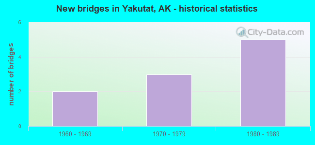
- New bridges - historical statistics
- 21960-1969
- 31970-1979
- 51980-1989


- Bridge Condition - Deck
- 71.4%Good
- 14.3%Satisfactory
- 14.3%Fair

- Bridge Condition - Superstructure
- 71.4%Good
- 28.6%Satisfactory

- Bridge Condition - Substructure
- 42.9%Good
- 28.6%Fair
- 28.6%Poor

- Bridge Condition - Channel
- 10.0%Very good
- 70.0%Good
- 20.0%Fair

- Bridge Condition - Culverts
- 66.7%Good
- 33.3%Satisfactory
Find on map >> Show street view
Structure Number: 1094, Location: MILE POINT 8.6 (Lat: 59.586153, Lng: -139.494842), Route carried "on" structure: State highway 942, Year Built: 1966, Status: Open, Structure Length: 3.15m (10.33ft), Average Daily Traffic: 40 (year 2020), Truck Traffic: 33%, Average Future Daily Traffic: 50 (year 2039), Design Load: HS 20, Features Intersected: SITUK RIVER, Facility Carried by Structure: IRR:YAKUT/ALSEK RD
Minimum Vertical Clearance: 30+ m (98+ ft), Kilometerpoint: 13.834, Lanes on structure: 2, Owner: State Highway Agency, Approaching Roadway Width: 8.5m (27.9ft), Material/Design: Steel continuous, Design/Construction: Stringer/Multi-beam, Number Of Spans In Main Unit: 2, Length of Maximum Span: 18.9m (62.0ft), Curb-To-Curb Width: 8.5m (27.9ft), Out-to-Out Width: 8.7m (28.5ft)
Condition: Deck: Good, Superstructure: Good, Substructure: Good, Channel: Good, Operating Rating: 68.0 metric tons, Method Used To Determine Operating Rating: Load Factor (LF), Inventory Rating: 32.0 metric tons, Method Used To Determine Inventory Rating: Load Factor (LF), Structural Evaluation: Better than present minimum criteria, Deck Geometry: Better than present minimum criteria, Waterway Adequacy: Equal to present desirable criteria, Approach Roadway Alignment: Equal to present desirable criteria, Designated Inspection Frequency: Every 24 months, Inspection Date: June 2020, Deck Structure Type: Concrete Cast-file-Place, Wearing Surface/Protective System: Wearing Surface: Monolithic Concrete
Find on map >> Show street view
Structure Number: 1112, Location: MILE POINT 4.6 (Lat: 59.545844, Lng: -139.823817), Route carried "on" structure: ServiceFederal lands road NSP00, Year Built: 1961, Status: Open, Structure Length: 15.09m (49.51ft), Average Daily Traffic: 457 (year 2018), Truck Traffic: 1%, Average Future Daily Traffic: 500 (year 2035), Design Load: HS 15, Features Intersected: ANKAU SLOUGH, Facility Carried by Structure: IRR:OCEAN CAPE RD
Minimum Vertical Clearance: 30+ m (98+ ft), Kilometerpoint: 7.403, Lanes on structure: 1, Owner: City or Municipal Highway Agency, Approaching Roadway Width: 3.8m (12.5ft), Material/Design: Wood or Timber, Design/Construction: Stringer/Multi-beam, Number Of Spans In Main Unit: 38, Length of Maximum Span: 4.0m (13.1ft), Curb-To-Curb Width: 3.7m (12.1ft), Out-to-Out Width: 4.0m (13.1ft)
Condition: Deck: Satisfactory, Superstructure: Satisfactory, Substructure: Poor, Channel: Good, Operating Rating: 26.1 metric tons, Method Used To Determine Operating Rating: Load Factor (LF), Inventory Rating: 19.7 metric tons, Method Used To Determine Inventory Rating: Load Factor (LF), Structural Evaluation: Meets minimum limits, Deck Geometry: High priority of replacement, Waterway Adequacy: Equal to present minimum criteria, Approach Roadway Alignment: Meets minimum limits, Designated Inspection Frequency: Every 24 months, Underwater Inspection Frequency: Every 60 months, Inspection Date: June 2020, Underwater Inspection Date: June 2021, Deck Structure Type: Wood or Timber, Wearing Surface/Protective System: Wearing Surface: Wood or Timber
Find on map >> Show street view
Structure Number: 1196, Location: MILE POINT 5.9 (Lat: 59.473569, Lng: -139.609631), Route carried "on" structure: State highway NSP00, Year Built: 1985, Status: Open, Structure Length: 3.06m (10.04ft), Average Daily Traffic: 100 (year 2020), Truck Traffic: 9%, Average Future Daily Traffic: 120 (year 2039), Design Load: HS 20, Features Intersected: LOST RIVER, Facility Carried by Structure: IRR:LOST RIVER RD
Minimum Vertical Clearance: 30+ m (98+ ft), Kilometerpoint: 9.490, Lanes on structure: 1, Owner: State Highway Agency, Approaching Roadway Width: 5.5m (18.0ft), Material/Design: Prestressed concrete, Design/Construction: Tee Beam, Number Of Spans In Main Unit: 3, Length of Maximum Span: 10.1m (33.1ft), Curb-To-Curb Width: 4.9m (16.1ft), Out-to-Out Width: 5.2m (17.1ft)
Condition: Deck: Good, Superstructure: Good, Substructure: Fair, Channel: Fair, Operating Rating: 53.3 metric tons, Method Used To Determine Operating Rating: Load Factor (LF), Inventory Rating: 24.5 metric tons, Method Used To Determine Inventory Rating: Load Factor (LF), Structural Evaluation: Somewhat better than minimum adequacy, Deck Geometry: High priority of corrective action, Waterway Adequacy: Better than present minimum criteria, Approach Roadway Alignment: Equal to present minimum criteria, Designated Inspection Frequency: Every 24 months, Inspection Date: June 2020, Deck Structure Type: Concrete Precast Panels, Wearing Surface/Protective System: Wearing Surface: Monolithic Concrete
Find on map >> Show street view
Structure Number: 2094, Location: YAKUTAT (Lat: 59.548572, Lng: -139.733375), Route carried "on" structure: ServiceCity street , Year Built: 1981, Status: Open, Structure Length: 13.26m (43.50ft), Average Daily Traffic: 926 (year 2018), Truck Traffic: 1%, Average Future Daily Traffic: 1,000 (year 2035), Design Load: HS 20, Features Intersected: YAKUTAT CITY DOCK, Facility Carried by Structure: SANDY BEACH ROAD
Minimum Vertical Clearance: 30+ m (98+ ft), Kilometerpoint: 0.864, Lanes on structure: 2, Toll: On toll road, Owner: City or Municipal Highway Agency, Approaching Roadway Width: 21.3m (69.9ft), Material/Design: Prestressed concrete, Design/Construction: Slab, Number Of Spans In Main Unit: 10, Number Of Approach Spans: 14, Length of Maximum Span: 5.2m (17.1ft), Curb-To-Curb Width: 14.6m (47.9ft), Out-to-Out Width: 15.2m (49.9ft)
Condition: Deck: Fair, Superstructure: Good, Substructure: Fair, Channel: Very good, Inventory Rating: 39.6 metric tons, Method Used To Determine Inventory Rating: Load Factor (LF), Structural Evaluation: Somewhat better than minimum adequacy, Deck Geometry: Superior to present desirable criteria, Waterway Adequacy: Superior to present desirable criteria, Approach Roadway Alignment: Equal to present minimum criteria, Designated Inspection Frequency: Every 24 months, Underwater Inspection Frequency: Every 60 months, Inspection Date: August 2021, Underwater Inspection Date: June 2021, Deck Structure Type: Concrete Cast-file-Place, Wearing Surface/Protective System: Wearing Surface: Monolithic Concrete, Deck Protection: Epoxy Coated Reinforcing
Find on map >> Show street view
Structure Number: 4072, Location: MILE POINT 26.5 (Lat: 59.451228, Lng: -139.060908), Route carried "on" structure: State highway 942, Year Built: 1976, Status: Open, Structure Length: 0.88m (2.89ft), Average Daily Traffic: 40 (year 2020), Truck Traffic: 33%, Average Future Daily Traffic: 50 (year 2039), Design Load: H 20, Features Intersected: MILLER CREEK WEST, Facility Carried by Structure: IRR:DANGEROUS RIV
Minimum Vertical Clearance: 30+ m (98+ ft), Kilometerpoint: 42.677, Lanes on structure: 2, Owner: State Highway Agency, Approaching Roadway Width: 6.9m (22.6ft), Material/Design: Steel, Design/Construction: Culvert, Number Of Spans In Main Unit: 2, Length of Maximum Span: 4.0m (13.1ft)
Condition: Channel: Good, Culverts: Good, Operating Rating: 40.5 metric tons, Method Used To Determine Operating Rating: Load Factor (LF), Inventory Rating: 33.7 metric tons, Method Used To Determine Inventory Rating: Load Factor (LF), Structural Evaluation: Better than present minimum criteria, Waterway Adequacy: Somewhat better than minimum adequacy, Approach Roadway Alignment: Equal to present desirable criteria, Designated Inspection Frequency: Every 24 months, Inspection Date: June 2020
Find on map >> Show street view
Structure Number: 4073, Location: MILE POINT 26.7 (Lat: 59.451136, Lng: -139.060617), Route carried "on" structure: State highway 942, Year Built: 1976, Status: Open, Structure Length: 0.88m (2.89ft), Average Daily Traffic: 40 (year 2020), Truck Traffic: 33%, Average Future Daily Traffic: 50 (year 2039), Design Load: H 20, Features Intersected: MILLER CREEK EAST, Facility Carried by Structure: IRR:DANGEROUS RIV
Minimum Vertical Clearance: 30+ m (98+ ft), Kilometerpoint: 42.889, Lanes on structure: 2, Owner: State Highway Agency, Approaching Roadway Width: 6.9m (22.6ft), Material/Design: Steel, Design/Construction: Culvert, Number Of Spans In Main Unit: 2, Length of Maximum Span: 4.0m (13.1ft)
Condition: Channel: Good, Culverts: Good, Structural Evaluation: Better than present minimum criteria, Waterway Adequacy: Somewhat better than minimum adequacy, Approach Roadway Alignment: Equal to present desirable criteria, Designated Inspection Frequency: Every 24 months, Inspection Date: June 2020
Find on map >> Show street view
Structure Number: 4074, Location: MILE POINT 10.9 (Lat: 59.570492, Lng: -139.437683), Route carried "on" structure: State highway , Year Built: 1976, Status: Open, Structure Length: 1.80m (5.91ft), Average Daily Traffic: 40 (year 2020), Truck Traffic: 33%, Average Future Daily Traffic: 50 (year 2039), Design Load: H 20, Features Intersected: OLD SITUK RIVER, Facility Carried by Structure: IRR:DANGEROUS RIV
Minimum Vertical Clearance: 30+ m (98+ ft), Kilometerpoint: 17.569, Lanes on structure: 2, Owner: State Highway Agency, Approaching Roadway Width: 8.5m (27.9ft), Skew: 4 degrees, Material/Design: Steel, Design/Construction: Culvert, Number Of Spans In Main Unit: 5, Length of Maximum Span: 1.8m (5.9ft)
Condition: Channel: Good, Culverts: Satisfactory, Structural Evaluation: Equal to present minimum criteria, Waterway Adequacy: Somewhat better than minimum adequacy, Approach Roadway Alignment: Equal to present desirable criteria, Designated Inspection Frequency: Every 24 months, Inspection Date: June 2020
Find on map >> Show street view
Structure Number: 100350000001318, Location: CANNON BEACH ROAD (Lat: 59.495850, Lng: -139.721950), Route carried "on" structure: Spur Federal lands road 9963, Year Built: 1985, Year Reconstructed: 1999, Status: Open, Structure Length: 2.18m (7.15ft), Features Intersected: TAWAH CREEK, Facility Carried by Structure: ROAD
Minimum Vertical Clearance: 30+ m (98+ ft), Kilometerpoint: 3.388, Lanes on structure: 1, Owner: U.S. Forest Service, Approaching Roadway Width: 4.9m (16.1ft), Material/Design: Wood or Timber, Design/Construction: Stringer/Multi-beam, Number Of Spans In Main Unit: 1, Length of Maximum Span: 21.0m (68.9ft), Curb-To-Curb Width: 4.3m (14.1ft), Out-to-Out Width: 4.6m (15.1ft)
Condition: Deck: Good, Superstructure: Good, Substructure: Good, Channel: Good, Operating Rating: 28.8 metric tons, Method Used To Determine Operating Rating: Load and Resistance Factor Rating (LRFR) rating reported by rating factor(RF) method using HL-93 loadings, Inventory Rating: 22.4 metric tons, Method Used To Determine Inventory Rating: Load and Resistance Factor Rating (LRFR) rating reported by rating factor(RF) method using HL-93 loadings, Structural Evaluation: Equal to present minimum criteria, Deck Geometry: Equal to present minimum criteria, Waterway Adequacy: Superior to present desirable criteria, Approach Roadway Alignment: Equal to present desirable criteria, Designated Inspection Frequency: Every 48 months, Inspection Date: May 2018, Deck Structure Type: Wood or Timber, Wearing Surface/Protective System: Wearing Surface: Gravel
Find on map >> Show street view
Structure Number: 10035000000132, Location: BROKEN BRIDGE ROAD (Lat: 59.481600, Lng: -139.648800), Route carried "on" structure: Spur Federal lands road 9976, Year Built: 1982, Year Reconstructed: 1999, Status: Open, Structure Length: 1.93m (6.33ft), Features Intersected: TAWAH CREEK, Facility Carried by Structure: ROAD
Minimum Vertical Clearance: 30+ m (98+ ft), Kilometerpoint: 0.451, Lanes on structure: 1, Owner: U.S. Forest Service, Approaching Roadway Width: 4.9m (16.1ft), Material/Design: Wood or Timber, Design/Construction: Stringer/Multi-beam, Number Of Spans In Main Unit: 1, Length of Maximum Span: 18.0m (59.1ft), Curb or Sidewalk Widths: Left: 0.3m (1.0ft), Right: 0.3m (1.0ft), Curb-To-Curb Width: 4.3m (14.1ft), Out-to-Out Width: 4.6m (15.1ft)
Condition: Deck: Good, Superstructure: Good, Substructure: Good, Channel: Good, Operating Rating: 37.3 metric tons, Method Used To Determine Operating Rating: Load and Resistance Factor Rating (LRFR) rating reported by rating factor(RF) method using HL-93 loadings, Inventory Rating: 28.5 metric tons, Method Used To Determine Inventory Rating: Load and Resistance Factor Rating (LRFR) rating reported by rating factor(RF) method using HL-93 loadings, Structural Evaluation: Better than present minimum criteria, Deck Geometry: Equal to present minimum criteria, Waterway Adequacy: Superior to present desirable criteria, Approach Roadway Alignment: Equal to present desirable criteria, Designated Inspection Frequency: Every 48 months, Inspection Date: May 2018, Deck Structure Type: Wood or Timber, Wearing Surface/Protective System: Wearing Surface: Wood or Timber
Find on map >> Show street view
Structure Number: 100350000001469, Location: W.F. SITUK ROAD (Lat: 59.620536, Lng: -139.527881), Route carried "on" structure: Federal lands road 9951, Year Built: 1985, Year Reconstructed: 1996, Status: Open, Structure Length: 2.44m (8.01ft), Features Intersected: W.F. SITUK, Facility Carried by Structure: PUBLIC ROAD
Minimum Vertical Clearance: 30+ m (98+ ft), Kilometerpoint: 7.177, Lanes on structure: 1, Owner: U.S. Forest Service, Approaching Roadway Width: 5.5m (18.0ft), Material/Design: Steel, Design/Construction: Stringer/Multi-beam, Number Of Spans In Main Unit: 1, Length of Maximum Span: 23.9m (78.4ft), Curb or Sidewalk Widths: Left: 0.3m (1.0ft), Right: 0.3m (1.0ft), Curb-To-Curb Width: 4.9m (16.1ft), Out-to-Out Width: 5.5m (18.0ft)
Condition: Deck: Good, Superstructure: Satisfactory, Substructure: Poor, Channel: Fair, Operating Rating: 25.6 metric tons, Method Used To Determine Operating Rating: Load and Resistance Factor Rating (LRFR) rating reported by rating factor(RF) method using HL-93 loadings, Inventory Rating: 19.8 metric tons, Method Used To Determine Inventory Rating: Load and Resistance Factor Rating (LRFR) rating reported by rating factor(RF) method using HL-93 loadings, Structural Evaluation: Meets minimum limits, Deck Geometry: High priority of corrective action, Waterway Adequacy: Equal to present desirable criteria, Approach Roadway Alignment: Equal to present desirable criteria, Designated Inspection Frequency: Every 24 months, Inspection Date: October 2021, Deck Structure Type: Wood or Timber, Wearing Surface/Protective System: Wearing Surface: Wood or Timber