Bridge Statistics for Yaphank, New York (NY)
Condition, Traffic, Stress, Structural Evaluation, Project Costs
- National Bridge Inventory (NBI) Statistics
- 22Number of bridges
- 331ft / 101mTotal length
- $110,214,000Total costs
- 558,970Total average daily traffic
- 28,641Total average daily truck traffic
- National Bridge Inventory (NBI) Registered Bridges for Yaphank
- No street view available for this location
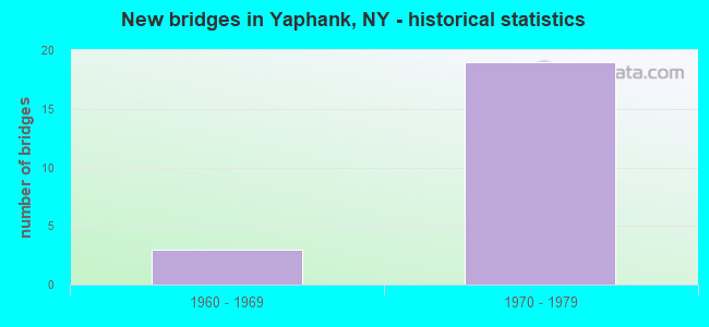
- New bridges - historical statistics
- 31960-1969
- 191970-1979

- Reconstructed bridges - Historical Statistics
- 12000-2009
- 12010-2019


- Bridge Condition - Deck
- 35.7%Good
- 57.1%Satisfactory
- 7.1%Fair

- Bridge Condition - Superstructure
- 28.6%Good
- 64.3%Satisfactory
- 7.1%Fair

- Bridge Condition - Substructure
- 28.6%Good
- 71.4%Satisfactory
Find on map >> Show street view
Structure Number: 1019319, Location: 5.2 MI E JCT SH27 & SH112 (Lat: 40.796756, Lng: -72.910106), Route carried "on" structure: County highway , Year Built: 1960, Status: Open, Structure Length: 7.35m (24.11ft), Average Daily Traffic: 13,501 (year 2020), Truck Traffic: 9%, Average Future Daily Traffic: 16,401 (year 2040), Design Load: HS 20, Features Intersected: 27 27 07051287, WB, RTE, Facility Carried by Structure: HORSE BLOCK ROAD
Minimum Vertical Clearance: 30+ m (98+ ft), Kilometerpoint: 25.100, Lanes on structure: 6, Lanes under structure: 6, Owner: State Highway Agency, Approaching Roadway Width: 21.9m (71.9ft), Skew: 20 degrees, Material/Design: Steel, Design/Construction: Stringer/Multi-beam, Number Of Spans In Main Unit: 4, Length of Maximum Span: 23.1m (75.8ft), Curb or Sidewalk Widths: Left: 2.7m (8.9ft), Right: 2.7m (8.9ft), Curb-To-Curb Width: 21.9m (71.9ft), Out-to-Out Width: 29.3m (96.1ft)
Condition: Deck: Good, Superstructure: Good, Substructure: Satisfactory, Operating Rating: 47.0 metric tons, Method Used To Determine Operating Rating: Load and Resistance Factor Rating (LRFR) rating reported by rating factor(RF) method using HL-93 loadings, Inventory Rating: 36.0 metric tons, Method Used To Determine Inventory Rating: Load and Resistance Factor Rating (LRFR) rating reported by rating factor(RF) method using HL-93 loadings, Structural Evaluation: Equal to present minimum criteria, Deck Geometry: High priority of corrective action, Underclear: High priority of corrective action, Approach Roadway Alignment: Equal to present desirable criteria, Length Of Structure Improvement: 7.34m (24.08ft), Designated Inspection Frequency: Every 24 months, Inspection Date: August 2021, Bridge Improvement Cost: $8,118,000, Roadway Improvement Cost: $4,754,000, Total Project Cost: $12,872,000 ( Estimate for 2021), Deck Structure Type: Concrete Cast-file-Place, Wearing Surface/Protective System: Wearing Surface: Integral Concrete
Find on map >> Show street view
Structure Number: 106414, Location: 2 MI E RTS 112+495 (Lat: 40.825225, Lng: -72.957689), Route carried "on" structure: Other road , Year Built: 1970, Status: Open, Structure Length: 7.22m (23.69ft), Average Daily Traffic: 5,268 (year 2018), Truck Traffic: 3%, Average Future Daily Traffic: 6,399 (year 2040), Design Load: HS 20, Features Intersected: 495I495I07041260 E/B, RT, Facility Carried by Structure: BELLPORT AVENUE
Minimum Vertical Clearance: 30+ m (98+ ft), Kilometerpoint: 6.758, Lanes on structure: 2, Lanes under structure: 6, Owner: State Highway Agency, Approaching Roadway Width: 8.5m (27.9ft), Skew: 1 degrees, Material/Design: Steel, Design/Construction: Stringer/Multi-beam, Number Of Spans In Main Unit: 4, Length of Maximum Span: 24.0m (78.7ft), Curb or Sidewalk Widths: Left: 1.5m (4.9ft), Right: 1.5m (4.9ft), Curb-To-Curb Width: 8.5m (27.9ft), Out-to-Out Width: 12.3m (40.4ft)
Condition: Deck: Satisfactory, Superstructure: Good, Substructure: Good, Operating Rating: 70.3 metric tons, Method Used To Determine Operating Rating: Load and Resistance Factor Rating (LRFR) rating reported by rating factor(RF) method using HL-93 loadings, Inventory Rating: 54.1 metric tons, Method Used To Determine Inventory Rating: Load and Resistance Factor Rating (LRFR) rating reported by rating factor(RF) method using HL-93 loadings, Structural Evaluation: Better than present minimum criteria, Deck Geometry: Meets minimum limits, Underclear: High priority of corrective action, Approach Roadway Alignment: Equal to present desirable criteria, Length Of Structure Improvement: 7.22m (23.69ft), Designated Inspection Frequency: Every 24 months, Inspection Date: June 2020, Bridge Improvement Cost: $3,526,000, Roadway Improvement Cost: $2,065,000, Total Project Cost: $5,590,000 ( Estimate for 2021), Deck Structure Type: Concrete Cast-file-Place, Wearing Surface/Protective System: Wearing Surface: Integral Concrete
Find on map >> Show street view
Structure Number: 1064151, Location: 3 MI E JCT SH 112 & I495 (Lat: 40.828958, Lng: -72.938489), Route carried "on" structure: Interstate 495, Year Built: 1970, Status: Open, Structure Length: 7.22m (23.69ft), Average Daily Traffic: 34,937 (year 1999), Truck Traffic: 13%, Design Load: HS 20, Features Intersected: SILLS ROAD, NB, SILLS RO
Minimum Vertical Clearance: 30+ m (98+ ft), Kilometerpoint: 43.443, Lanes on structure: 3, Lanes under structure: 5, Base Highway Network: Yes, Owner: State Highway Agency, Approaching Roadway Width: 15.8m (51.8ft), Skew: 3 degrees, Material/Design: Steel, Design/Construction: Stringer/Multi-beam, Number Of Spans In Main Unit: 4, Length of Maximum Span: 20.4m (66.9ft), Curb or Sidewalk Widths: Left: 0.4m (1.3ft), Right: 0.4m (1.3ft), Curb-To-Curb Width: 12.2m (40.0ft), Out-to-Out Width: 13.7m (44.9ft)
Condition: Deck: Satisfactory, Superstructure: Satisfactory, Substructure: Good, Operating Rating: 57.2 metric tons, Method Used To Determine Operating Rating: Load Factor (LF), Inventory Rating: 34.5 metric tons, Method Used To Determine Inventory Rating: Load Factor (LF), Structural Evaluation: Equal to present minimum criteria, Deck Geometry: High priority of corrective action, Underclear: Meets minimum limits, Approach Roadway Alignment: Equal to present desirable criteria, Length Of Structure Improvement: 7.22m (23.69ft), Designated Inspection Frequency: Every 24 months, Inspection Date: August 2021, Bridge Improvement Cost: $3,915,000, Roadway Improvement Cost: $2,293,000, Total Project Cost: $6,208,000 ( Estimate for 2021), Deck Structure Type: Concrete Cast-file-Place, Wearing Surface/Protective System: Wearing Surface: Monolithic Concrete
Find on map >> Show street view
Structure Number: 1064152, Location: 3 MI E JCT SH 112 & I495 (Lat: 40.828703, Lng: -72.938372), Route carried "on" structure: Interstate 495, Year Built: 1970, Status: Open, Structure Length: 7.22m (23.69ft), Average Daily Traffic: 44,553 (year 2018), Truck Traffic: 5%, Average Future Daily Traffic: 46,780 (year 2040), Design Load: HS 20, Features Intersected: SILLS ROAD, NB, SILLS RO
Minimum Vertical Clearance: 30+ m (98+ ft), Kilometerpoint: 43.443, Lanes on structure: 3, Lanes under structure: 5, Base Highway Network: Yes, Owner: State Highway Agency, Approaching Roadway Width: 15.8m (51.8ft), Skew: 3 degrees, Material/Design: Steel, Design/Construction: Stringer/Multi-beam, Number Of Spans In Main Unit: 4, Length of Maximum Span: 20.4m (66.9ft), Curb or Sidewalk Widths: Left: 0.4m (1.3ft), Right: 0.4m (1.3ft), Curb-To-Curb Width: 12.2m (40.0ft), Out-to-Out Width: 13.7m (44.9ft)
Condition: Deck: Good, Superstructure: Satisfactory, Substructure: Good, Operating Rating: 55.3 metric tons, Method Used To Determine Operating Rating: Load Factor (LF), Inventory Rating: 32.7 metric tons, Method Used To Determine Inventory Rating: Load Factor (LF), Structural Evaluation: Equal to present minimum criteria, Deck Geometry: High priority of corrective action, Underclear: Meets minimum limits, Approach Roadway Alignment: Equal to present desirable criteria, Length Of Structure Improvement: 7.22m (23.69ft), Designated Inspection Frequency: Every 24 months, Inspection Date: August 2021, Bridge Improvement Cost: $3,915,000, Roadway Improvement Cost: $2,293,000, Total Project Cost: $6,208,000 ( Estimate for 2021), Deck Structure Type: Concrete Cast-file-Place, Wearing Surface/Protective System: Wearing Surface: Monolithic Concrete
Find on map >> Show street view
Structure Number: 106416, Location: 4.1 MI E JCT SH112 & I495 (Lat: 40.832439, Lng: -72.917122), Route carried "on" structure: County highway , Year Built: 1970, Year Reconstructed: 2015, Status: Open, Structure Length: 7.74m (25.39ft), Average Daily Traffic: 8,705 (year 2019), Truck Traffic: 6%, Average Future Daily Traffic: 10,770 (year 2040), Design Load: HS 20, Features Intersected: 495I 495I07041281, W/B,, Facility Carried by Structure: YAPHANK AVENUE
Minimum Vertical Clearance: 30+ m (98+ ft), Kilometerpoint: 3.942, Lanes on structure: 4, Lanes under structure: 6, Owner: State Highway Agency, Approaching Roadway Width: 14.6m (47.9ft), Skew: 22 degrees, Material/Design: Steel, Design/Construction: Stringer/Multi-beam, Number Of Spans In Main Unit: 4, Length of Maximum Span: 26.2m (86.0ft), Curb or Sidewalk Widths: Left: 1.5m (4.9ft), Right: 1.5m (4.9ft), Curb-To-Curb Width: 14.6m (47.9ft), Out-to-Out Width: 18.4m (60.4ft)
Condition: Deck: Satisfactory, Superstructure: Satisfactory, Substructure: Good, Operating Rating: 78.9 metric tons, Method Used To Determine Operating Rating: Load Factor (LF), Inventory Rating: 47.2 metric tons, Method Used To Determine Inventory Rating: Load Factor (LF), Structural Evaluation: Equal to present minimum criteria, Deck Geometry: High priority of replacement, Underclear: High priority of corrective action, Approach Roadway Alignment: Better than present minimum criteria, Length Of Structure Improvement: 7.74m (25.39ft), Designated Inspection Frequency: Every 24 months, Inspection Date: June 2021, Bridge Improvement Cost: $5,483,000, Roadway Improvement Cost: $3,211,000, Total Project Cost: $8,693,000 ( Estimate for 2021), Deck Structure Type: Concrete Cast-file-Place, Wearing Surface/Protective System: Wearing Surface: Integral Concrete
Find on map >> Show street view
Structure Number: 1064171, Location: 4.4 MI E RTS 112+495 (Lat: 40.833792, Lng: -72.911794), Route carried "on" structure: Interstate 495, Year Built: 1970, Status: Open, Structure Length: 2.47m (8.10ft), Average Daily Traffic: 39,829 (year 2008), Truck Traffic: 13%, Design Load: HS 20, Features Intersected: CARMANS RIVER
Minimum Vertical Clearance: 30+ m (98+ ft), Kilometerpoint: 45.808, Lanes on structure: 3, Base Highway Network: Yes, Owner: State Highway Agency, Approaching Roadway Width: 15.5m (50.9ft), Skew: 2 degrees, Material/Design: Steel, Design/Construction: Stringer/Multi-beam, Number Of Spans In Main Unit: 1, Length of Maximum Span: 23.4m (76.8ft), Curb-To-Curb Width: 15.5m (50.9ft), Out-to-Out Width: 16.6m (54.5ft)
Condition: Deck: Good, Superstructure: Good, Substructure: Satisfactory, Channel: Good, Operating Rating: 72.6 metric tons, Method Used To Determine Operating Rating: Load Factor (LF), Inventory Rating: 43.5 metric tons, Method Used To Determine Inventory Rating: Load Factor (LF), Structural Evaluation: Equal to present minimum criteria, Deck Geometry: Somewhat better than minimum adequacy, Waterway Adequacy: Superior to present desirable criteria, Approach Roadway Alignment: Equal to present desirable criteria, Length Of Structure Improvement: 2.46m (8.07ft), Designated Inspection Frequency: Every 24 months, Inspection Date: November 2021, Bridge Improvement Cost: $2,280,000, Roadway Improvement Cost: $1,335,000, Total Project Cost: $3,616,000 ( Estimate for 2021), Deck Structure Type: Concrete Cast-file-Place, Wearing Surface/Protective System: Wearing Surface: Monolithic Concrete
Find on map >> Show street view
Structure Number: 1064172, Location: 4.4 MI E RTS 112+495 (Lat: 40.833578, Lng: -72.911564), Route carried "on" structure: Interstate 495, Year Built: 1970, Status: Open, Structure Length: 2.47m (8.10ft), Average Daily Traffic: 39,440 (year 2018), Truck Traffic: 5%, Average Future Daily Traffic: 41,411 (year 2040), Design Load: HS 20, Features Intersected: CARMANS RIVER
Minimum Vertical Clearance: 30+ m (98+ ft), Kilometerpoint: 45.808, Lanes on structure: 4, Base Highway Network: Yes, Owner: State Highway Agency, Approaching Roadway Width: 16.5m (54.1ft), Skew: 2 degrees, Material/Design: Steel, Design/Construction: Stringer/Multi-beam, Number Of Spans In Main Unit: 1, Length of Maximum Span: 23.4m (76.8ft), Curb-To-Curb Width: 16.3m (53.5ft), Out-to-Out Width: 17.6m (57.7ft)
Condition: Deck: Good, Superstructure: Good, Substructure: Satisfactory, Channel: Good, Operating Rating: 65.3 metric tons, Method Used To Determine Operating Rating: Load Factor (LF), Inventory Rating: 39.0 metric tons, Method Used To Determine Inventory Rating: Load Factor (LF), Structural Evaluation: Equal to present minimum criteria, Deck Geometry: High priority of replacement, Waterway Adequacy: Superior to present desirable criteria, Approach Roadway Alignment: Equal to present desirable criteria, Length Of Structure Improvement: 2.46m (8.07ft), Designated Inspection Frequency: Every 24 months, Inspection Date: November 2021, Bridge Improvement Cost: $2,610,000, Roadway Improvement Cost: $1,528,000, Total Project Cost: $4,138,000 ( Estimate for 2021), Deck Structure Type: Concrete Cast-file-Place, Wearing Surface/Protective System: Wearing Surface: Monolithic Concrete
Find on map >> Show street view
Structure Number: 106418, Location: 4.7 MI E RTS 112+495 (Lat: 40.836075, Lng: -72.905814), Route carried "on" structure: Other road , Year Built: 1970, Status: Open, Structure Length: 9.05m (29.69ft), Average Daily Traffic: 4,246 (year 2020), Truck Traffic: 8%, Average Future Daily Traffic: 5,158 (year 2040), Design Load: HS 20, Features Intersected: 495I 495I 0704 1288, E/B, Facility Carried by Structure: BROADWAY,MAIN ST
Minimum Vertical Clearance: 30+ m (98+ ft), Kilometerpoint: 0.917, Lanes on structure: 2, Lanes under structure: 6, Owner: State Highway Agency, Approaching Roadway Width: 8.5m (27.9ft), Skew: 3 degrees, Material/Design: Steel, Design/Construction: Stringer/Multi-beam, Number Of Spans In Main Unit: 4, Length of Maximum Span: 30.1m (98.8ft), Curb or Sidewalk Widths: Left: 1.5m (4.9ft), Right: 1.5m (4.9ft), Curb-To-Curb Width: 8.5m (27.9ft), Out-to-Out Width: 12.3m (40.4ft)
Condition: Deck: Satisfactory, Superstructure: Satisfactory, Substructure: Satisfactory, Operating Rating: 68.0 metric tons, Method Used To Determine Operating Rating: Load Factor (LF), Inventory Rating: 40.8 metric tons, Method Used To Determine Inventory Rating: Load Factor (LF), Structural Evaluation: Equal to present minimum criteria, Deck Geometry: Meets minimum limits, Underclear: High priority of corrective action, Approach Roadway Alignment: Better than present minimum criteria, Length Of Structure Improvement: 9.05m (29.69ft), Designated Inspection Frequency: Every 24 months, Inspection Date: October 2021, Bridge Improvement Cost: $4,349,000, Roadway Improvement Cost: $2,547,000, Total Project Cost: $6,896,000 ( Estimate for 2021), Deck Structure Type: Concrete Cast-file-Place, Wearing Surface/Protective System: Wearing Surface: Integral Concrete
Find on map >> Show street view
Structure Number: 1064191, Location: 5.7 MI E RTS 112+495 (Lat: 40.844053, Lng: -72.890756), Route carried "on" structure: Interstate 495, Year Built: 1970, Status: Open, Structure Length: 6.22m (20.41ft), Average Daily Traffic: 39,829 (year 2009), Truck Traffic: 13%, Design Load: HS 20, Features Intersected: WILLIAM FLOYD PKY NB, WI
Minimum Vertical Clearance: 30+ m (98+ ft), Kilometerpoint: 47.900, Lanes on structure: 6, Lanes under structure: 6, Base Highway Network: Yes, Owner: State Highway Agency, Approaching Roadway Width: 28.0m (91.9ft), Skew: 20 degrees, Material/Design: Steel, Design/Construction: Stringer/Multi-beam, Number Of Spans In Main Unit: 4, Length of Maximum Span: 19.2m (63.0ft), Curb or Sidewalk Widths: Left: 0.6m (2.0ft), Right: 0.4m (1.3ft), Curb-To-Curb Width: 28.1m (92.2ft), Out-to-Out Width: 30.1m (98.8ft)
Condition: Deck: Satisfactory, Superstructure: Satisfactory, Substructure: Satisfactory, Operating Rating: 64.4 metric tons, Method Used To Determine Operating Rating: Load Factor (LF), Inventory Rating: 38.1 metric tons, Method Used To Determine Inventory Rating: Load Factor (LF), Structural Evaluation: Equal to present minimum criteria, Deck Geometry: Equal to present minimum criteria, Underclear: Somewhat better than minimum adequacy, Approach Roadway Alignment: Equal to present desirable criteria, Length Of Structure Improvement: 6.21m (20.37ft), Designated Inspection Frequency: Every 24 months, Inspection Date: November 2021, Bridge Improvement Cost: $7,373,000, Roadway Improvement Cost: $4,318,000, Total Project Cost: $11,691,000 ( Estimate for 2021), Deck Structure Type: Concrete Cast-file-Place, Wearing Surface/Protective System: Wearing Surface: Monolithic Concrete
Find on map >> Show street view
Structure Number: 1064192, Location: 5.7 MI E RTS 112+495 (Lat: 40.843831, Lng: -72.890558), Route carried "on" structure: Interstate 495, Year Built: 1970, Year Reconstructed: 2013, Status: Open, Structure Length: 6.22m (20.41ft), Average Daily Traffic: 39,440 (year 2020), Truck Traffic: 6%, Average Future Daily Traffic: 41,411 (year 2040), Design Load: HS 20, Features Intersected: WILLIAM FLOYD PKY NB, WI
Minimum Vertical Clearance: 30+ m (98+ ft), Kilometerpoint: 47.900, Lanes on structure: 6, Lanes under structure: 6, Base Highway Network: Yes, Owner: State Highway Agency, Approaching Roadway Width: 28.0m (91.9ft), Skew: 20 degrees, Material/Design: Steel, Design/Construction: Stringer/Multi-beam, Number Of Spans In Main Unit: 4, Length of Maximum Span: 19.2m (63.0ft), Curb or Sidewalk Widths: Left: 0.7m (2.3ft), Right: 0.4m (1.3ft), Curb-To-Curb Width: 28.2m (92.5ft), Out-to-Out Width: 30.1m (98.8ft)
Condition: Deck: Satisfactory, Superstructure: Satisfactory, Substructure: Satisfactory, Operating Rating: 64.4 metric tons, Method Used To Determine Operating Rating: Load Factor (LF), Inventory Rating: 38.1 metric tons, Method Used To Determine Inventory Rating: Load Factor (LF), Structural Evaluation: Equal to present minimum criteria, Deck Geometry: Equal to present minimum criteria, Underclear: High priority of corrective action, Approach Roadway Alignment: Equal to present desirable criteria, Length Of Structure Improvement: 6.21m (20.37ft), Designated Inspection Frequency: Every 24 months, Inspection Date: November 2021, Bridge Improvement Cost: $7,373,000, Roadway Improvement Cost: $4,318,000, Total Project Cost: $11,691,000 ( Estimate for 2021), Deck Structure Type: Concrete Cast-file-Place, Wearing Surface/Protective System: Wearing Surface: Monolithic Concrete
Find on map >> Show street view
Structure Number: 3300789, Location: 1.8 MI EAST OF YAPHANK (Lat: 40.838747, Lng: -72.887294), Route carried "on" structure: County highway , Year Built: 1960, Status: Open, Structure Length: 5.15m (16.90ft), Average Daily Traffic: 26,236 (year 2018), Truck Traffic: 4%, Average Future Daily Traffic: 31,207 (year 2040), Features Intersected: LIRR MAIN LINE, Facility Carried by Structure: WILLIAM FLOYD PKY
Minimum Vertical Clearance: 30+ m (98+ ft), Kilometerpoint: 12.212, Lanes on structure: 4, Owner: County Highway Agency, Approaching Roadway Width: 17.1m (56.1ft), Skew: 20 degrees, Material/Design: Concrete continuous, Design/Construction: Tee Beam, Number Of Spans In Main Unit: 3, Length of Maximum Span: 20.4m (66.9ft), Curb or Sidewalk Widths: Left: 1.0m (3.3ft), Right: 1.0m (3.3ft), Curb-To-Curb Width: 17.1m (56.1ft), Out-to-Out Width: 21.3m (69.9ft)
Condition: Deck: Fair, Superstructure: Fair, Substructure: Satisfactory, Operating Rating: 36.9 metric tons, Method Used To Determine Operating Rating: Load and Resistance Factor Rating (LRFR) rating reported by rating factor(RF) method using HL-93 loadings, Inventory Rating: 26.2 metric tons, Method Used To Determine Inventory Rating: Load and Resistance Factor Rating (LRFR) rating reported by rating factor(RF) method using HL-93 loadings, Structural Evaluation: Somewhat better than minimum adequacy, Deck Geometry: High priority of corrective action, Underclear: Better than present minimum criteria, Approach Roadway Alignment: Equal to present desirable criteria, Length Of Structure Improvement: 5.15m (16.90ft), Designated Inspection Frequency: Every 24 months, Inspection Date: July 2020, Bridge Improvement Cost: $3,197,000, Roadway Improvement Cost: $1,872,000, Total Project Cost: $5,070,000 ( Estimate for 2021), Deck Structure Type: Concrete Cast-file-Place, Wearing Surface/Protective System: Wearing Surface: Bituminous
Find on map >> Show street view
Structure Number: 3364521, Location: 1.5 MI W OF YAPHANK (Lat: 40.822194, Lng: -72.942772), Route carried "on" structure: County highway , Year Built: 1976, Status: Open, Structure Length: 9.75m (31.99ft), Average Daily Traffic: 9,901 (year 2020), Truck Traffic: 16%, Average Future Daily Traffic: 12,027 (year 2040), Design Load: HS 20, Features Intersected: LIRR MAIN LINE, Facility Carried by Structure: SILLS ROAD
Minimum Vertical Clearance: 30+ m (98+ ft), Kilometerpoint: 7.257, Lanes on structure: 2, Owner: County Highway Agency, Approaching Roadway Width: 7.9m (25.9ft), Skew: 4 degrees, Material/Design: Steel, Design/Construction: Stringer/Multi-beam, Number Of Spans In Main Unit: 5, Length of Maximum Span: 22.8m (74.8ft), Curb or Sidewalk Widths: Left: 0.4m (1.3ft), Right: 0.4m (1.3ft), Curb-To-Curb Width: 7.9m (25.9ft), Out-to-Out Width: 9.4m (30.8ft)
Condition: Deck: Satisfactory, Superstructure: Satisfactory, Substructure: Satisfactory, Operating Rating: 69.3 metric tons, Method Used To Determine Operating Rating: Load and Resistance Factor Rating (LRFR) rating reported by rating factor(RF) method using HL-93 loadings, Inventory Rating: 53.5 metric tons, Method Used To Determine Inventory Rating: Load and Resistance Factor Rating (LRFR) rating reported by rating factor(RF) method using HL-93 loadings, Structural Evaluation: Equal to present minimum criteria, Deck Geometry: High priority of replacement, Underclear: Somewhat better than minimum adequacy, Approach Roadway Alignment: Equal to present desirable criteria, Length Of Structure Improvement: 9.75m (31.99ft), Designated Inspection Frequency: Every 24 months, Inspection Date: July 2020, Bridge Improvement Cost: $3,671,000, Roadway Improvement Cost: $2,150,000, Total Project Cost: $5,821,000 ( Estimate for 2021), Deck Structure Type: Concrete Cast-file-Place, Wearing Surface/Protective System: Wearing Surface: Latex Concrete
Find on map >> Show street view
Structure Number: 3364522, Location: 1.5 MI W OF YAPHANK (Lat: 40.822219, Lng: -72.942531), Route carried "on" structure: County highway , Year Built: 1976, Status: Open, Structure Length: 9.63m (31.59ft), Average Daily Traffic: 9,901 (year 2020), Truck Traffic: 16%, Average Future Daily Traffic: 12,027 (year 2040), Design Load: HS 20, Features Intersected: LIRR MAIN LINE, Facility Carried by Structure: SILLS RD NB
Minimum Vertical Clearance: 30+ m (98+ ft), Kilometerpoint: 7.257, Lanes on structure: 2, Owner: County Highway Agency, Approaching Roadway Width: 7.9m (25.9ft), Skew: 4 degrees, Material/Design: Steel, Design/Construction: Stringer/Multi-beam, Number Of Spans In Main Unit: 5, Length of Maximum Span: 22.2m (72.8ft), Curb or Sidewalk Widths: Left: 0.4m (1.3ft), Right: 0.4m (1.3ft), Curb-To-Curb Width: 7.9m (25.9ft), Out-to-Out Width: 9.4m (30.8ft)
Condition: Deck: Good, Superstructure: Satisfactory, Substructure: Satisfactory, Operating Rating: 63.5 metric tons, Method Used To Determine Operating Rating: Load and Resistance Factor Rating (LRFR) rating reported by rating factor(RF) method using HL-93 loadings, Inventory Rating: 48.9 metric tons, Method Used To Determine Inventory Rating: Load and Resistance Factor Rating (LRFR) rating reported by rating factor(RF) method using HL-93 loadings, Structural Evaluation: Equal to present minimum criteria, Deck Geometry: High priority of replacement, Underclear: Somewhat better than minimum adequacy, Approach Roadway Alignment: Equal to present desirable criteria, Length Of Structure Improvement: 9.63m (31.59ft), Designated Inspection Frequency: Every 24 months, Inspection Date: July 2020, Bridge Improvement Cost: $3,634,000, Roadway Improvement Cost: $2,128,000, Total Project Cost: $5,763,000 ( Estimate for 2021), Deck Structure Type: Concrete Cast-file-Place, Wearing Surface/Protective System: Wearing Surface: Latex Concrete
Find on map >> Show street view
Structure Number: 3364539, Location: AT YAPHANK (Lat: 40.825194, Lng: -72.916761), Route carried "on" structure: County highway , Year Built: 1978, Status: Open, Structure Length: 13.32m (43.70ft), Average Daily Traffic: 9,130 (year 2020), Truck Traffic: 8%, Average Future Daily Traffic: 12,782 (year 2040), Design Load: HS 20, Features Intersected: Yaphank Avenue, LONG ISL, Facility Carried by Structure: YAPHANK AVENUE
Minimum Vertical Clearance: 30+ m (98+ ft), Kilometerpoint: 3.154, Lanes on structure: 2, Lanes under structure: 2, Owner: County Highway Agency, Approaching Roadway Width: 15.2m (49.9ft), Skew: 20 degrees, Material/Design: Steel, Design/Construction: Stringer/Multi-beam, Number Of Spans In Main Unit: 5, Length of Maximum Span: 26.2m (86.0ft), Curb or Sidewalk Widths: Left: 0.9m (3.0ft), Right: 0.9m (3.0ft), Curb-To-Curb Width: 15.2m (49.9ft), Out-to-Out Width: 18.9m (62.0ft)
Condition: Deck: Satisfactory, Superstructure: Satisfactory, Substructure: Satisfactory, Operating Rating: 61.6 metric tons, Method Used To Determine Operating Rating: Load and Resistance Factor Rating (LRFR) rating reported by rating factor(RF) method using HL-93 loadings, Inventory Rating: 47.6 metric tons, Method Used To Determine Inventory Rating: Load and Resistance Factor Rating (LRFR) rating reported by rating factor(RF) method using HL-93 loadings, Structural Evaluation: Equal to present minimum criteria, Deck Geometry: Superior to present desirable criteria, Underclear: High priority of corrective action, Approach Roadway Alignment: Equal to present minimum criteria, Length Of Structure Improvement: 13.31m (43.67ft), Designated Inspection Frequency: Every 24 months, Inspection Date: August 2020, Bridge Improvement Cost: $10,064,000, Roadway Improvement Cost: $5,893,000, Total Project Cost: $15,957,000 ( Estimate for 2021), Deck Structure Type: Concrete Cast-file-Place, Wearing Surface/Protective System: Wearing Surface: Bituminous
Find on map >> Show street view
Structure Number: 1019319, Location: 5.2 MI E JCT SH27 & SH112 (Lat: 40.796756, Lng: -72.910106), Route carried "under" structure: State highway 27, Year Built: 1960, Structure Length: 0. m, Average Daily Traffic: 18,500 (year 1973), Features Intersected: 27 27 07051287, WB, RTE, Facility Carried by Structure: HORSE BLOCK ROAD
Minimum Vertical Clearance: 4.39m (14.40ft), Kilometerpoint: 46.210, Lanes on structure: 6, Lanes under structure: 3, Material/Design: Steel, Design/Construction: Stringer/Multi-beam, Length of Maximum Span: 23.1m (75.8ft)
Find on map >> Show street view
Structure Number: 106414, Location: 2 MI E RTS 112+495 (Lat: 40.825225, Lng: -72.957689), Route carried "under" structure: Interstate 495, Year Built: 1970, Structure Length: 0. m, Average Daily Traffic: 37,300 (year 1978), Features Intersected: 495I495I07041260 E/B, RT, Facility Carried by Structure: BELLPORT AVENUE
Minimum Vertical Clearance: 4.60m (15.09ft), Kilometerpoint: 41.834, Lanes on structure: 2, Lanes under structure: 3, Material/Design: Steel, Design/Construction: Stringer/Multi-beam, Length of Maximum Span: 24.0m (78.7ft)
Find on map >> Show street view
Structure Number: 1064151, Location: 3 MI E JCT SH 112 & I495 (Lat: 40.828958, Lng: -72.938489), Route carried "under" structure: Other road , Year Built: 1970, Structure Length: 0. m, Average Daily Traffic: 17,720 (year 2004), Features Intersected: SILLS ROAD, NB, SILLS RO, Facility Carried by Structure: RTE I495
Minimum Vertical Clearance: 4.47m (14.67ft), Kilometerpoint: 0.000, Lanes on structure: 3, Lanes under structure: 2, Material/Design: Steel, Design/Construction: Stringer/Multi-beam, Length of Maximum Span: 20.4m (66.9ft)
Find on map >> Show street view
Structure Number: 1064152, Location: 3 MI E JCT SH 112 & I495 (Lat: 40.828703, Lng: -72.938372), Route carried "under" structure: Other road , Year Built: 1970, Structure Length: 0. m, Average Daily Traffic: 17,720 (year 2004), Features Intersected: SILLS ROAD, NB, SILLS RO, Facility Carried by Structure: RTE I495
Minimum Vertical Clearance: 4.42m (14.50ft), Kilometerpoint: 0.000, Lanes on structure: 3, Lanes under structure: 2, Material/Design: Steel, Design/Construction: Stringer/Multi-beam, Length of Maximum Span: 20.4m (66.9ft)
Find on map >> Show street view
Structure Number: 106416, Location: 4.1 MI E JCT SH112 & I495 (Lat: 40.832439, Lng: -72.917122), Route carried "under" structure: Interstate 495, Year Built: 1970, Structure Length: 0. m, Average Daily Traffic: 37,300 (year 1978), Features Intersected: 495I 495I07041281, W/B,, Facility Carried by Structure: YAPHANK AVENUE
Minimum Vertical Clearance: 4.98m (16.34ft), Kilometerpoint: 45.326, Lanes on structure: 4, Lanes under structure: 3, Material/Design: Steel, Design/Construction: Stringer/Multi-beam, Length of Maximum Span: 26.2m (86.0ft)
Find on map >> Show street view
Structure Number: 106418, Location: 4.7 MI E RTS 112+495 (Lat: 40.836075, Lng: -72.905814), Route carried "under" structure: Interstate 495, Year Built: 1970, Structure Length: 0. m, Average Daily Traffic: 37,300 (year 1978), Features Intersected: 495I 495I 0704 1288, E/B, Facility Carried by Structure: BROADWAY,MAIN ST
Minimum Vertical Clearance: 5.18m (16.99ft), Kilometerpoint: 46.404, Lanes on structure: 2, Lanes under structure: 3, Material/Design: Steel, Design/Construction: Stringer/Multi-beam, Length of Maximum Span: 30.1m (98.8ft)
Find on map >> Show street view
Structure Number: 1064191, Location: 5.7 MI E RTS 112+495 (Lat: 40.844053, Lng: -72.890756), Route carried "under" structure: County highway , Year Built: 1970, Structure Length: 0. m, Average Daily Traffic: 34,107 (year 2004), Features Intersected: WILLIAM FLOYD PKY NB, WI, Facility Carried by Structure: RTE I495
Minimum Vertical Clearance: 5.05m (16.57ft), Kilometerpoint: 0.000, Lanes on structure: 6, Lanes under structure: 3, Material/Design: Steel, Design/Construction: Stringer/Multi-beam, Length of Maximum Span: 19.2m (63.0ft)
Find on map >> Show street view
Structure Number: 1064192, Location: 5.7 MI E RTS 112+495 (Lat: 40.843831, Lng: -72.890558), Route carried "under" structure: County highway , Year Built: 1970, Structure Length: 0. m, Average Daily Traffic: 34,107 (year 2004), Features Intersected: WILLIAM FLOYD PKY NB, WI, Facility Carried by Structure: RTE I495
Minimum Vertical Clearance: 4.47m (14.67ft), Kilometerpoint: 0.000, Lanes on structure: 6, Lanes under structure: 3, Material/Design: Steel, Design/Construction: Stringer/Multi-beam, Length of Maximum Span: 19.2m (63.0ft)