Bridge Statistics for Yatesville, Pennsylvania (PA)
Condition, Traffic, Stress, Structural Evaluation, Project Costs
- National Bridge Inventory (NBI) Statistics
- 14Number of bridges
- 75ft / 23.4mTotal length
- $1,701,000Total costs
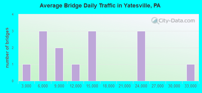
- 172,815Total average daily traffic
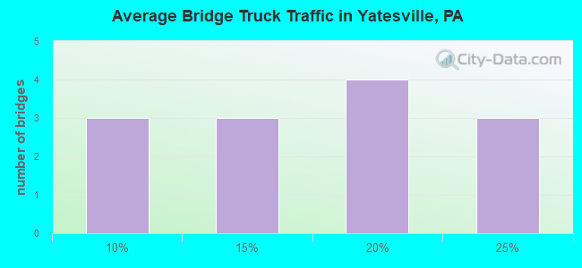
- 29,008Total average daily truck traffic
- National Bridge Inventory (NBI) Registered Bridges for Yatesville
- No street view available for this location
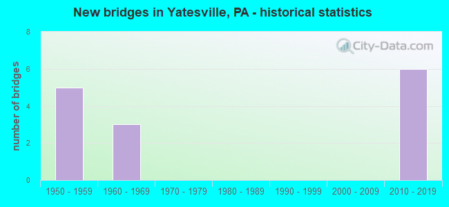
- New bridges - historical statistics
- 51950-1959
- 31960-1969
- 62010-2019
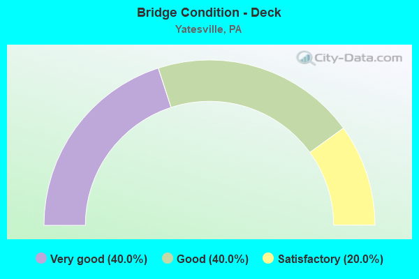
- Bridge Condition - Deck
- 40.0%Very good
- 40.0%Good
- 20.0%Satisfactory

- Bridge Condition - Superstructure
- 20.0%Very good
- 20.0%Good
- 40.0%Satisfactory
- 20.0%Fair
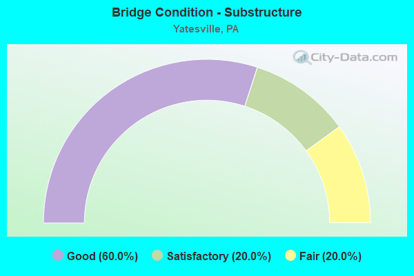
- Bridge Condition - Substructure
- 60.0%Good
- 20.0%Satisfactory
- 20.0%Fair
Find on map >> Show street view
Structure Number: 241, Location: PITTSTON TWP OVER I-81 (Lat: 41.306453, Lng: -75.765978), Route carried "on" structure: State highway , Year Built: 1963, Year Reconstructed: 1993, Status: Open, Structure Length: 4.18m (13.71ft), Average Daily Traffic: 11,297 (year 2022), Truck Traffic: 6%, Average Future Daily Traffic: 14,771 (year 2032), Design Load: HS 20, Features Intersected: SR 0081 INTERSTATE 81, Facility Carried by Structure: SR 2019 OAK STREET
Minimum Vertical Clearance: 30+ m (98+ ft), Kilometerpoint: 0.000, Lanes on structure: 3, Lanes under structure: 4, Owner: State Highway Agency, Approaching Roadway Width: 12.8m (42.0ft), Skew: 1 degrees, Material/Design: Prestressed concrete, Design/Construction: Box Beam or Girders - Single/Spread, Number Of Spans In Main Unit: 2, Length of Maximum Span: 20.7m (67.9ft), Curb or Sidewalk Widths: Left: 0.2m (0.7ft), Right: 0.2m (0.7ft), Curb-To-Curb Width: 12.8m (42.0ft), Out-to-Out Width: 14.0m (45.9ft)
Condition: Deck: Satisfactory, Superstructure: Fair, Substructure: Fair, Operating Rating: 76.2 metric tons, Method Used To Determine Operating Rating: Load Factor (LF), Inventory Rating: 31.8 metric tons, Method Used To Determine Inventory Rating: Load Factor (LF), Structural Evaluation: Somewhat better than minimum adequacy, Deck Geometry: Meets minimum limits, Underclear: High priority of corrective action, Approach Roadway Alignment: Equal to present desirable criteria, Length Of Structure Improvement: 5.20m (17.06ft), Designated Inspection Frequency: Every 24 months, Inspection Date: October 2020, Deck Structure Type: Concrete Cast-file-Place, Wearing Surface/Protective System: Wearing Surface: Monolithic Concrete, Deck Protection: Epoxy Coated Reinforcing
Find on map >> Show street view
Structure Number: 24485, Location: NEAR YATESVILLE (Lat: 41.302653, Lng: -75.764172), Route carried "on" structure: Interstate 476, Year Built: 1956, Year Reconstructed: 1994, Status: Open, Structure Length: 4.45m (14.60ft), Average Daily Traffic: 6,576 (year 2001), Truck Traffic: 16%, Average Future Daily Traffic: 9,415 (year 2030), Design Load: HS 20, Features Intersected: CENTERPOINTE BLVD
Minimum Vertical Clearance: 30+ m (98+ ft), Kilometerpoint: 0.000, Lanes on structure: 4, Lanes under structure: 2, Base Highway Network: Yes, Toll: On toll road, Owner: State Toll Authority, Approaching Roadway Width: 21.9m (71.9ft), Skew: 33 degrees, Material/Design: Steel continuous, Design/Construction: Stringer/Multi-beam, Number Of Spans In Main Unit: 3, Length of Maximum Span: 17.4m (57.1ft), Curb or Sidewalk Widths: Left: 0.2m (0.7ft), Right: 0.2m (0.7ft), Curb-To-Curb Width: 18.2m (59.7ft), Out-to-Out Width: 18.9m (62.0ft)
Condition: Deck: Good, Superstructure: Satisfactory, Substructure: Satisfactory, Operating Rating: 73.5 metric tons, Method Used To Determine Operating Rating: Load Factor (LF), Inventory Rating: 43.5 metric tons, Method Used To Determine Inventory Rating: Load Factor (LF), Structural Evaluation: Equal to present minimum criteria, Deck Geometry: Meets minimum limits, Underclear: Meets minimum limits, Approach Roadway Alignment: Equal to present desirable criteria, Length Of Structure Improvement: 5.40m (17.72ft), Designated Inspection Frequency: Every 48 months, Inspection Date: June 2019, Bridge Improvement Cost: $126,000, Roadway Improvement Cost: $371,000, Total Project Cost: $1,701,000, Deck Structure Type: Concrete Cast-file-Place, Wearing Surface/Protective System: Wearing Surface: Latex Concrete
Find on map >> Show street view
Structure Number: 24486, Location: PITTSTON TWP OVER TR 315 (Lat: 41.307322, Lng: -75.759817), Route carried "on" structure: ServiceInterstate 476, Year Built: 1957, Year Reconstructed: 1994, Status: Open, Structure Length: 4.18m (13.71ft), Average Daily Traffic: 6,576 (year 2001), Truck Traffic: 16%, Average Future Daily Traffic: 9,415 (year 2030), Design Load: HS 20, Features Intersected: SR 0315
Minimum Vertical Clearance: 30+ m (98+ ft), Kilometerpoint: 0.000, Lanes on structure: 2, Lanes under structure: 8, Base Highway Network: Yes, Owner: State Toll Authority, Approaching Roadway Width: 11.0m (36.1ft), Skew: 30 degrees, Material/Design: Steel continuous, Design/Construction: Stringer/Multi-beam, Number Of Spans In Main Unit: 3, Length of Maximum Span: 25.6m (84.0ft), Curb or Sidewalk Widths: Left: 0.2m (0.7ft), Right: 0.2m (0.7ft), Curb-To-Curb Width: 9.8m (32.2ft), Out-to-Out Width: 11.5m (37.7ft)
Condition: Deck: Good, Superstructure: Satisfactory, Substructure: Good, Operating Rating: 78.9 metric tons, Method Used To Determine Operating Rating: Load Factor (LF), Inventory Rating: 47.2 metric tons, Method Used To Determine Inventory Rating: Load Factor (LF), Structural Evaluation: Equal to present minimum criteria, Deck Geometry: Meets minimum limits, Underclear: Somewhat better than minimum adequacy, Approach Roadway Alignment: Equal to present desirable criteria, Length Of Structure Improvement: 5.20m (17.06ft), Designated Inspection Frequency: Every 24 months, Critical Feature Inspection Frequency: Every 24 months, Inspection Date: June 2021, Critical Feature Inspection Date: June 2021, Deck Structure Type: Concrete Cast-file-Place, Wearing Surface/Protective System: Wearing Surface: Latex Concrete, Deck Protection: Epoxy Coated Reinforcing
Find on map >> Show street view
Structure Number: 54527, Location: JENKIS TWP OVER TR 315 (Lat: 41.303333, Lng: -75.768333), Route carried "on" structure: Interstate 81, Year Built: 2017, Status: Open, Structure Length: 5.00m (16.40ft), Average Daily Traffic: 21,153 (year 2020), Truck Traffic: 24%, Average Future Daily Traffic: 37,231 (year 2032), Design Load: HL 93, Features Intersected: SR 0315 TR 315
Minimum Vertical Clearance: 30+ m (98+ ft), Kilometerpoint: 55.918, Lanes on structure: 2, Lanes under structure: 4, Base Highway Network: Yes, Owner: State Highway Agency, Approaching Roadway Width: 11.0m (36.1ft), Skew: 5 degrees, Material/Design: Steel, Design/Construction: Stringer/Multi-beam, Number Of Spans In Main Unit: 1, Length of Maximum Span: 48.8m (160.1ft), Curb or Sidewalk Widths: Left: 0.2m (0.7ft), Right: 0.2m (0.7ft), Curb-To-Curb Width: 18.3m (60.0ft), Out-to-Out Width: 19.3m (63.3ft)
Condition: Deck: Very good, Superstructure: Good, Substructure: Good, Operating Rating: 58.6 metric tons, Method Used To Determine Operating Rating: Assigned ratings based on Load and Resistance Factor Design (LRFD) reported by rating factor (RF) using HL93 loadings, Inventory Rating: 45.0 metric tons, Method Used To Determine Inventory Rating: Assigned ratings based on Load and Resistance Factor Design (LRFD) reported by rating factor (RF) using HL93 loadings, Structural Evaluation: Better than present minimum criteria, Deck Geometry: Superior to present desirable criteria, Underclear: Meets minimum limits, Approach Roadway Alignment: Equal to present desirable criteria, Designated Inspection Frequency: Every 24 months, Inspection Date: August 2021, Deck Structure Type: Concrete Cast-file-Place, Wearing Surface/Protective System: Wearing Surface: Monolithic Concrete, Deck Protection: Epoxy Coated Reinforcing
Find on map >> Show street view
Structure Number: 54627, Location: JENKINS TWP OVER TR 315 (Lat: 41.302833, Lng: -75.768889), Route carried "on" structure: Interstate 81, Year Built: 2017, Status: Open, Structure Length: 5.61m (18.41ft), Average Daily Traffic: 30,533 (year 2021), Truck Traffic: 17%, Average Future Daily Traffic: 39,912 (year 2037), Design Load: HL 93, Features Intersected: SR 0315 TR 315
Minimum Vertical Clearance: 30+ m (98+ ft), Kilometerpoint: 56.137, Lanes on structure: 3, Lanes under structure: 5, Base Highway Network: Yes, Owner: State Highway Agency, Approaching Roadway Width: 11.0m (36.1ft), Skew: 5 degrees, Material/Design: Steel, Design/Construction: Stringer/Multi-beam, Number Of Spans In Main Unit: 1, Length of Maximum Span: 53.3m (174.9ft), Curb or Sidewalk Widths: Left: 0.2m (0.7ft), Right: 0.2m (0.7ft), Curb-To-Curb Width: 19.5m (64.0ft), Out-to-Out Width: 20.5m (67.3ft)
Condition: Deck: Very good, Superstructure: Very good, Substructure: Good, Operating Rating: 60.9 metric tons, Method Used To Determine Operating Rating: Assigned ratings based on Load and Resistance Factor Design (LRFD) reported by rating factor (RF) using HL93 loadings, Inventory Rating: 47.3 metric tons, Method Used To Determine Inventory Rating: Assigned ratings based on Load and Resistance Factor Design (LRFD) reported by rating factor (RF) using HL93 loadings, Structural Evaluation: Better than present minimum criteria, Deck Geometry: Superior to present desirable criteria, Underclear: Meets minimum limits, Approach Roadway Alignment: Equal to present desirable criteria, Designated Inspection Frequency: Every 24 months, Inspection Date: August 2021, Deck Structure Type: Concrete Cast-file-Place, Wearing Surface/Protective System: Wearing Surface: Monolithic Concrete, Deck Protection: Epoxy Coated Reinforcing
Find on map >> Show street view
Structure Number: 241, Location: PITTSTON TWP OVER I-81 (Lat: 41.306453, Lng: -75.765978), Route carried "under" structure: Interstate 81, Year Built: 1963, Structure Length: 0. m, Average Daily Traffic: 21,360 (year 2020), Truck Traffic: 24%, Features Intersected: SR 0081 INTERSTATE 81, Facility Carried by Structure: SR 2019 OAK STREET
Minimum Vertical Clearance: 5.12m (16.80ft), Kilometerpoint: 56.905, Lanes on structure: 3, Lanes under structure: 2, Material/Design: Prestressed concrete, Design/Construction: Box Beam or Girders - Single/Spread, Length of Maximum Span: 20.7m (67.9ft)
Find on map >> Show street view
Structure Number: 241, Location: PITTSTON TWP OVER I-81 (Lat: 41.306453, Lng: -75.765978), Route carried "under" structure: Interstate 81, Year Built: 1963, Structure Length: 0. m, Average Daily Traffic: 21,153 (year 2020), Truck Traffic: 24%, Features Intersected: SR 0081 INTERSTATE 81, Facility Carried by Structure: SR 2019 OAK STREET
Minimum Vertical Clearance: 5.24m (17.19ft), Kilometerpoint: 56.659, Lanes on structure: 3, Lanes under structure: 2, Material/Design: Prestressed concrete, Design/Construction: Box Beam or Girders - Single/Spread, Length of Maximum Span: 20.7m (67.9ft)
Find on map >> Show street view
Structure Number: 24485, Location: NEAR YATESVILLE (Lat: 41.302653, Lng: -75.764172), Route carried "under" structure: Business City street , Year Built: 1956, Structure Length: 0. m, Average Daily Traffic: 200 (year 1992), Features Intersected: CENTERPOINTE BLVD, Facility Carried by Structure: PA TPK (I-476)
Minimum Vertical Clearance: 6.24m (20.47ft), Kilometerpoint: 0.000, Lanes on structure: 4, Lanes under structure: 2, Toll: On toll road, Material/Design: Steel continuous, Design/Construction: Stringer/Multi-beam, Length of Maximum Span: 17.4m (57.1ft)
Find on map >> Show street view
Structure Number: 24486, Location: PITTSTON TWP OVER TR 315 (Lat: 41.307322, Lng: -75.759817), Route carried "under" structure: State highway 315, Year Built: 1957, Structure Length: 0. m, Average Daily Traffic: 5,911 (year 2022), Truck Traffic: 18%, Features Intersected: SR 0315, Facility Carried by Structure: PA TPK (I-476)
Minimum Vertical Clearance: 4.62m (15.16ft), Kilometerpoint: 8.661, Lanes on structure: 2, Lanes under structure: 4, Material/Design: Steel continuous, Design/Construction: Stringer/Multi-beam, Length of Maximum Span: 25.6m (84.0ft)
Find on map >> Show street view
Structure Number: 24486, Location: PITTSTON TWP OVER TR 315 (Lat: 41.307322, Lng: -75.759817), Route carried "under" structure: State highway 315, Year Built: 1957, Structure Length: 0. m, Average Daily Traffic: 12,420 (year 2022), Truck Traffic: 10%, Features Intersected: SR 0315, Facility Carried by Structure: PA TPK (I-476)
Minimum Vertical Clearance: 4.62m (15.16ft), Kilometerpoint: 8.668, Lanes on structure: 2, Lanes under structure: 4, Material/Design: Steel continuous, Design/Construction: Stringer/Multi-beam, Length of Maximum Span: 25.6m (84.0ft)
Find on map >> Show street view
Structure Number: 54527, Location: JENKIS TWP OVER TR 315 (Lat: 41.303333, Lng: -75.768333), Route carried "under" structure: State highway 315, Year Built: 2017, Structure Length: 0. m, Average Daily Traffic: 5,398 (year 2021), Truck Traffic: 9%, Features Intersected: SR 0315 TR 315, Facility Carried by Structure: SR 0081 1-81 NB
Minimum Vertical Clearance: 5.39m (17.68ft), Kilometerpoint: 8.230, Lanes on structure: 2, Lanes under structure: 2, Material/Design: Steel, Design/Construction: Stringer/Multi-beam, Length of Maximum Span: 48.8m (160.1ft)
Find on map >> Show street view
Structure Number: 54527, Location: JENKIS TWP OVER TR 315 (Lat: 41.303333, Lng: -75.768333), Route carried "under" structure: State highway 315, Year Built: 2017, Structure Length: 0. m, Average Daily Traffic: 12,420 (year 2022), Truck Traffic: 10%, Features Intersected: SR 0315 TR 315, Facility Carried by Structure: SR 0081 1-81 NB
Minimum Vertical Clearance: 4.79m (15.72ft), Kilometerpoint: 8.253, Lanes on structure: 2, Lanes under structure: 2, Material/Design: Steel, Design/Construction: Stringer/Multi-beam, Length of Maximum Span: 48.8m (160.1ft)
Find on map >> Show street view
Structure Number: 54627, Location: JENKINS TWP OVER TR 315 (Lat: 41.302833, Lng: -75.768889), Route carried "under" structure: State highway 315, Year Built: 2017, Structure Length: 0. m, Average Daily Traffic: 5,398 (year 2021), Truck Traffic: 9%, Features Intersected: SR 0315 TR 315, Facility Carried by Structure: SR 0081 I-81 SB
Minimum Vertical Clearance: 5.63m (18.47ft), Kilometerpoint: 8.230, Lanes on structure: 3, Lanes under structure: 2, Material/Design: Steel, Design/Construction: Stringer/Multi-beam, Length of Maximum Span: 53.3m (174.9ft)
Find on map >> Show street view
Structure Number: 54627, Location: JENKINS TWP OVER TR 315 (Lat: 41.302833, Lng: -75.768889), Route carried "under" structure: State highway 315, Year Built: 2017, Structure Length: 0. m, Average Daily Traffic: 12,420 (year 2022), Truck Traffic: 10%, Features Intersected: SR 0315 TR 315, Facility Carried by Structure: SR 0081 I-81 SB
Minimum Vertical Clearance: 4.94m (16.21ft), Kilometerpoint: 8.253, Lanes on structure: 3, Lanes under structure: 3, Material/Design: Steel, Design/Construction: Stringer/Multi-beam, Length of Maximum Span: 53.3m (174.9ft)