Bridge Statistics for Yogaville, Virginia (VA)
Condition, Traffic, Stress, Structural Evaluation, Project Costs
- National Bridge Inventory (NBI) Statistics
- 10Number of bridges
- 230ft / 70.0mTotal length
- $1,564,000Total costs
- 1,821Total average daily traffic
- 25Total average daily truck traffic
- 2,092Total future (year 2040) average daily traffic
- National Bridge Inventory (NBI) Registered Bridges for Yogaville
- No street view available for this location
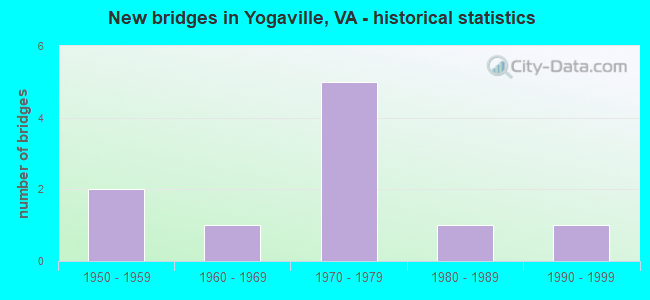
- New bridges - historical statistics
- 21950-1959
- 11960-1969
- 51970-1979
- 11980-1989
- 11990-1999

- Reconstructed bridges - Historical Statistics
- 12000-2009
- 12010-2019

- Bridge Condition - Deck
- 14.3%Very good
- 14.3%Good
- 71.4%Satisfactory

- Bridge Condition - Superstructure
- 14.3%Very good
- 14.3%Good
- 42.9%Satisfactory
- 28.6%Fair

- Bridge Condition - Substructure
- 57.1%Good
- 42.9%Satisfactory

- Bridge Condition - Channel
- 30.0%Good
- 70.0%Satisfactory
Find on map >> Show street view
Structure Number: 667, Location: 0.00NELSON CL/O.11 TO 602 (Lat: 37.732478, Lng: -78.648383), Route carried "on" structure: County highway 626, Year Built: 1971, Status: Open, Structure Length: 6.56m (21.52ft), Average Daily Traffic: 199 (year 2018), Average Future Daily Traffic: 221 (year 2040), Design Load: HS 20+Mod, Features Intersected: ROCKFISH RIVER, Facility Carried by Structure: JAMES RIVER ROAD
Minimum Vertical Clearance: 30+ m (98+ ft), Kilometerpoint: 0.016, Lanes on structure: 2, Owner: State Highway Agency, Approaching Roadway Width: 6.1m (20.0ft), Skew: 3 degrees, Material/Design: Concrete, Design/Construction: Tee Beam, Number Of Spans In Main Unit: 3, Number Of Approach Spans: 2, Length of Maximum Span: 13.0m (42.7ft), Curb or Sidewalk Widths: Left: 0.2m (0.7ft), Right: 0.2m (0.7ft), Curb-To-Curb Width: 7.0m (23.0ft), Out-to-Out Width: 9.8m (32.2ft)
Condition: Deck: Satisfactory, Superstructure: Satisfactory, Substructure: Good, Channel: Satisfactory, Operating Rating: 65.3 metric tons, Method Used To Determine Operating Rating: Load and Resistance Factor (LRFR), Inventory Rating: 50.8 metric tons, Method Used To Determine Inventory Rating: Load and Resistance Factor (LRFR), Structural Evaluation: Equal to present minimum criteria, Deck Geometry: Meets minimum limits, Waterway Adequacy: Equal to present minimum criteria, Approach Roadway Alignment: Equal to present desirable criteria, Designated Inspection Frequency: Every 24 months, Inspection Date: June 2021, Deck Structure Type: Concrete Cast-file-Place, Wearing Surface/Protective System: Wearing Surface: Epoxy Overlay
Find on map >> Show street view
Structure Number: 4032, Location: 2.00-Rt.737/1.10-Rt.604 (Lat: 37.678647, Lng: -78.665986), Route carried "on" structure: County highway 601, Year Built: 1952, Status: Posted for load, Structure Length: 3.45m (11.32ft), Average Daily Traffic: 233 (year 2019), Truck Traffic: 3%, Average Future Daily Traffic: 237 (year 2040), Design Load: HS 15, Features Intersected: Sycamore Creek, Facility Carried by Structure: Manteo Road
Minimum Vertical Clearance: 30+ m (98+ ft), Kilometerpoint: 11.858, Lanes on structure: 2, Owner: State Highway Agency, Approaching Roadway Width: 5.5m (18.0ft), Material/Design: Steel, Design/Construction: Stringer/Multi-beam, Number Of Spans In Main Unit: 3, Length of Maximum Span: 10.6m (34.8ft), Curb or Sidewalk Widths: Left: 0.3m (1.0ft), Right: 0.3m (1.0ft), Curb-To-Curb Width: 6.1m (20.0ft), Out-to-Out Width: 7.3m (24.0ft)
Condition: Deck: Satisfactory, Superstructure: Fair, Substructure: Satisfactory, Channel: Satisfactory, Operating Rating: 27.2 metric tons, Method Used To Determine Operating Rating: Load Factor (LF), Inventory Rating: 16.3 metric tons, Method Used To Determine Inventory Rating: Load Factor (LF), Structural Evaluation: Somewhat better than minimum adequacy, Deck Geometry: Meets minimum limits, Waterway Adequacy: Equal to present minimum criteria, Approach Roadway Alignment: Equal to present minimum criteria, Bridge Posting: Required (Relationship of Operating Rating to Maximum Legal Load: 20.0 - 29.9% below), Length Of Structure Improvement: 4.30m (14.11ft), Designated Inspection Frequency: Every 12 months, Inspection Date: Febuary 2022, Bridge Improvement Cost: $750,000, Roadway Improvement Cost: $75,000, Total Project Cost: $1,125,000 ( Estimate for 2015), Deck Structure Type: Concrete Cast-file-Place
Find on map >> Show street view
Structure Number: 4039, Location: 0.26-NelsonCL/0.92-Rt.653 (Lat: 37.730544, Lng: -78.640439), Route carried "on" structure: County highway 602, Year Built: 1971, Status: Open, Structure Length: 0.85m (2.79ft), Average Daily Traffic: 260 (year 2015), Average Future Daily Traffic: 292 (year 2040), Features Intersected: Tributary James River, Facility Carried by Structure: Howardsville Rd.
Minimum Vertical Clearance: 30+ m (98+ ft), Kilometerpoint: 23.089, Lanes on structure: 2, Owner: State Highway Agency, Approaching Roadway Width: 6.7m (22.0ft), Skew: 3 degrees, Material/Design: Steel, Design/Construction: Culvert, Number Of Spans In Main Unit: 3, Length of Maximum Span: 2.4m (7.9ft)
Condition: Channel: Satisfactory, Culverts: Good, Operating Rating: 49.9 metric tons, Method Used To Determine Operating Rating: Field evaluation and documented engineering judgment, Inventory Rating: 29.9 metric tons, Method Used To Determine Inventory Rating: Field evaluation and documented engineering judgment, Structural Evaluation: Better than present minimum criteria, Waterway Adequacy: Equal to present minimum criteria, Approach Roadway Alignment: Equal to present desirable criteria, Designated Inspection Frequency: Every 24 months, Inspection Date: May 2021
Find on map >> Show street view
Structure Number: 404, Location: 0.00-Buck CL/0.00-Nel CL (Lat: 37.731503, Lng: -78.646025), Route carried "on" structure: County highway 602, Year Built: 1970, Status: Open, Structure Length: 28.85m (94.65ft), Average Daily Traffic: 304 (year 2020), Average Future Daily Traffic: 426 (year 2040), Design Load: HS 20+Mod, Features Intersected: James River, Facility Carried by Structure: Howardsville Rd.
Minimum Vertical Clearance: 30+ m (98+ ft), Kilometerpoint: 0.016, Lanes on structure: 2, Owner: State Highway Agency, Approaching Roadway Width: 7.3m (24.0ft), Material/Design: Steel, Design/Construction: Stringer/Multi-beam, Number Of Spans In Main Unit: 8, Length of Maximum Span: 36.3m (119.1ft), Curb or Sidewalk Widths: Left: 0.2m (0.7ft), Right: 0.2m (0.7ft), Curb-To-Curb Width: 10.0m (32.8ft), Out-to-Out Width: 11.2m (36.7ft)
Condition: Deck: Satisfactory, Superstructure: Satisfactory, Substructure: Satisfactory, Channel: Satisfactory, Operating Rating: 67.1 metric tons, Method Used To Determine Operating Rating: Load and Resistance Factor (LRFR), Inventory Rating: 51.7 metric tons, Method Used To Determine Inventory Rating: Load and Resistance Factor (LRFR), Structural Evaluation: Equal to present minimum criteria, Deck Geometry: Better than present minimum criteria, Waterway Adequacy: Better than present minimum criteria, Approach Roadway Alignment: Equal to present minimum criteria, Designated Inspection Frequency: Every 24 months, Underwater Inspection Frequency: Every 60 months, Inspection Date: November 2021, Underwater Inspection Date: May 2017, Deck Structure Type: Concrete Cast-file-Place
Find on map >> Show street view
Structure Number: 1244, Location: 0.0-NelsonCo./0.0-BkgmCo (Lat: 37.636372, Lng: -78.720033), Route carried "on" structure: State highway 56, Year Built: 1973, Status: Open, Structure Length: 23.47m (77.00ft), Average Daily Traffic: 324 (year 2020), Truck Traffic: 6%, Average Future Daily Traffic: 361 (year 2040), Design Load: HS 20+Mod, Features Intersected: James River, Facility Carried by Structure: James River Road
Minimum Vertical Clearance: 30+ m (98+ ft), Kilometerpoint: 80.844, Lanes on structure: 2, Owner: State Highway Agency, Approaching Roadway Width: 10.0m (32.8ft), Material/Design: Steel, Design/Construction: Stringer/Multi-beam, Number Of Spans In Main Unit: 8, Length of Maximum Span: 36.0m (118.1ft), Curb or Sidewalk Widths: Left: 0.2m (0.7ft), Right: 0.2m (0.7ft), Curb-To-Curb Width: 10.0m (32.8ft), Out-to-Out Width: 11.2m (36.7ft)
Condition: Deck: Satisfactory, Superstructure: Fair, Substructure: Satisfactory, Channel: Good, Operating Rating: 64.4 metric tons, Method Used To Determine Operating Rating: Load and Resistance Factor (LRFR), Inventory Rating: 49.9 metric tons, Method Used To Determine Inventory Rating: Load and Resistance Factor (LRFR), Structural Evaluation: Somewhat better than minimum adequacy, Deck Geometry: Better than present minimum criteria, Waterway Adequacy: Equal to present minimum criteria, Approach Roadway Alignment: Equal to present desirable criteria, Designated Inspection Frequency: Every 24 months, Underwater Inspection Frequency: Every 60 months, Inspection Date: July 2020, Underwater Inspection Date: May 2017, Deck Structure Type: Concrete Cast-file-Place
Find on map >> Show street view
Structure Number: 12491, Location: 3.90-Rt.644 / 0.37-Rt.604 (Lat: 37.693978, Lng: -78.701753), Route carried "on" structure: County highway 626, Year Built: 1994, Year Reconstructed: 2010, Status: Open, Structure Length: 0.74m (2.43ft), Average Daily Traffic: 106 (year 2020), Average Future Daily Traffic: 117 (year 2040), Features Intersected: Slater Branch, Facility Carried by Structure: Cabell Road
Minimum Vertical Clearance: 30+ m (98+ ft), Kilometerpoint: 26.964, Lanes on structure: 2, Owner: State Highway Agency, Approaching Roadway Width: 4.9m (16.1ft), Skew: 4 degrees, Material/Design: Steel, Design/Construction: Culvert, Number Of Spans In Main Unit: 2, Length of Maximum Span: 3.4m (11.2ft)
Condition: Channel: Satisfactory, Culverts: Good, Operating Rating: 52.6 metric tons, Method Used To Determine Operating Rating: Field evaluation and documented engineering judgment, Inventory Rating: 31.8 metric tons, Method Used To Determine Inventory Rating: Field evaluation and documented engineering judgment, Structural Evaluation: Better than present minimum criteria, Waterway Adequacy: Somewhat better than minimum adequacy, Approach Roadway Alignment: Equal to present desirable criteria, Designated Inspection Frequency: Every 24 months, Inspection Date: December 2020
Find on map >> Show street view
Structure Number: 12493, Location: 2.00-Rt.743 / 0.20-Rt.604 (Lat: 37.685767, Lng: -78.704497), Route carried "on" structure: County highway 626, Year Built: 1951, Status: Posted for load, Structure Length: 1.01m (3.31ft), Average Daily Traffic: 106 (year 2020), Average Future Daily Traffic: 117 (year 2040), Features Intersected: Swan Creek, Facility Carried by Structure: Cabell Road
Minimum Vertical Clearance: 30+ m (98+ ft), Kilometerpoint: 26.040, Lanes on structure: 2, Owner: State Highway Agency, Approaching Roadway Width: 4.9m (16.1ft), Material/Design: Steel, Design/Construction: Stringer/Multi-beam, Number Of Spans In Main Unit: 1, Length of Maximum Span: 9.0m (29.5ft), Curb or Sidewalk Widths: Left: 0.3m (1.0ft), Right: 0.3m (1.0ft), Curb-To-Curb Width: 6.1m (20.0ft), Out-to-Out Width: 6.7m (22.0ft)
Condition: Deck: Satisfactory, Superstructure: Satisfactory, Substructure: Good, Channel: Satisfactory, Operating Rating: 39.0 metric tons, Method Used To Determine Operating Rating: Load Factor (LF), Inventory Rating: 23.6 metric tons, Method Used To Determine Inventory Rating: Load Factor (LF), Structural Evaluation: Equal to present minimum criteria, Deck Geometry: Meets minimum limits, Waterway Adequacy: Better than present minimum criteria, Approach Roadway Alignment: Equal to present minimum criteria, Length Of Structure Improvement: 1.68m (5.51ft), Designated Inspection Frequency: Every 24 months, Inspection Date: May 2020, Bridge Improvement Cost: $293,000, Roadway Improvement Cost: $29,000, Total Project Cost: $439,000 ( Estimate for 2014), Deck Structure Type: Concrete Cast-file-Place, Wearing Surface/Protective System: Wearing Surface: Bituminous
Find on map >> Show street view
Structure Number: 12494, Location: 0.10-Rt 743/ 0.70-Rt 56 (Lat: 37.671622, Lng: -78.733414), Route carried "on" structure: County highway 626, Year Built: 1979, Status: Open, Structure Length: 0.67m (2.20ft), Average Daily Traffic: 106 (year 2020), Average Future Daily Traffic: 117 (year 2040), Design Load: HS 20, Features Intersected: Mayo Creek, Facility Carried by Structure: Cabell Road
Minimum Vertical Clearance: 30+ m (98+ ft), Kilometerpoint: 22.666, Lanes on structure: 2, Owner: State Highway Agency, Approaching Roadway Width: 5.4m (17.7ft), Material/Design: Concrete, Design/Construction: Culvert, Number Of Spans In Main Unit: 2, Length of Maximum Span: 3.0m (9.8ft)
Condition: Channel: Good, Culverts: Good, Operating Rating: 68.9 metric tons, Method Used To Determine Operating Rating: Load Factor (LF), Inventory Rating: 40.8 metric tons, Method Used To Determine Inventory Rating: Load Factor (LF), Structural Evaluation: Better than present minimum criteria, Waterway Adequacy: Better than present minimum criteria, Approach Roadway Alignment: Better than present minimum criteria, Designated Inspection Frequency: Every 24 months, Inspection Date: September 2021
Find on map >> Show street view
Structure Number: 12527, Location: 0.02-Rt.646E/0.18-Rt.646W (Lat: 37.730644, Lng: -78.725431), Route carried "on" structure: County highway 645, Year Built: 1988, Status: Open, Structure Length: 2.93m (9.61ft), Average Daily Traffic: 21 (year 2020), Average Future Daily Traffic: 23 (year 2040), Design Load: HS 20+Mod, Features Intersected: Beaver Creek, Facility Carried by Structure: Aerial Road
Minimum Vertical Clearance: 30+ m (98+ ft), Kilometerpoint: 1.738, Lanes on structure: 2, Owner: State Highway Agency, Approaching Roadway Width: 4.9m (16.1ft), Material/Design: Concrete, Design/Construction: Slab, Number Of Spans In Main Unit: 3, Length of Maximum Span: 9.0m (29.5ft), Curb-To-Curb Width: 7.5m (24.6ft), Out-to-Out Width: 8.5m (27.9ft)
Condition: Deck: Good, Superstructure: Good, Substructure: Good, Channel: Good, Operating Rating: 89.8 metric tons, Method Used To Determine Operating Rating: Load and Resistance Factor (LRFR), Inventory Rating: 88.9 metric tons, Method Used To Determine Inventory Rating: Load and Resistance Factor (LRFR), Structural Evaluation: Better than present minimum criteria, Deck Geometry: Equal to present minimum criteria, Waterway Adequacy: Equal to present desirable criteria, Approach Roadway Alignment: Equal to present desirable criteria, Designated Inspection Frequency: Every 24 months, Inspection Date: August 2020, Deck Structure Type: Concrete Cast-file-Place, Wearing Surface/Protective System: Deck Protection: Epoxy Coated Reinforcing
Find on map >> Show street view
Structure Number: 12533, Location: 2.50-Rt.56 / 1.00-Rt.626 (Lat: 37.641675, Lng: -78.762411), Route carried "on" structure: County highway 647, Year Built: 1965, Year Reconstructed: 2011, Status: Open, Structure Length: 1.46m (4.79ft), Average Daily Traffic: 162 (year 2017), Average Future Daily Traffic: 181 (year 2040), Design Load: HL 93, Features Intersected: Union Hill Creek, Facility Carried by Structure: Norwood Road
Minimum Vertical Clearance: 30+ m (98+ ft), Kilometerpoint: 4.507, Lanes on structure: 2, Owner: State Highway Agency, Approaching Roadway Width: 4.6m (15.1ft), Skew: 3 degrees, Material/Design: Prestressed concrete, Design/Construction: Box Beam or Girders - Multiple, Number Of Spans In Main Unit: 1, Length of Maximum Span: 13.0m (42.7ft), Curb-To-Curb Width: 6.4m (21.0ft), Out-to-Out Width: 8.2m (26.9ft)
Condition: Deck: Very good, Superstructure: Very good, Substructure: Good, Channel: Satisfactory, Operating Rating: 55.3 metric tons, Method Used To Determine Operating Rating: Load and Resistance Factor (LRFR), Inventory Rating: 42.6 metric tons, Method Used To Determine Inventory Rating: Load and Resistance Factor (LRFR), Structural Evaluation: Better than present minimum criteria, Deck Geometry: Meets minimum limits, Waterway Adequacy: Somewhat better than minimum adequacy, Approach Roadway Alignment: Equal to present minimum criteria, Designated Inspection Frequency: Every 24 months, Inspection Date: June 2021, Deck Structure Type: Concrete Precast Panels, Wearing Surface/Protective System: Wearing Surface: Bituminous