Bridge Statistics for York, Alabama (AL)
Condition, Traffic, Stress, Structural Evaluation, Project Costs
- National Bridge Inventory (NBI) Statistics
- 34Number of bridges
- 400ft / 122mTotal length
- $55,065,000Total costs
- 246,597Total average daily traffic
- 99,358Total average daily truck traffic
- National Bridge Inventory (NBI) Registered Bridges for York
- No street view available for this location
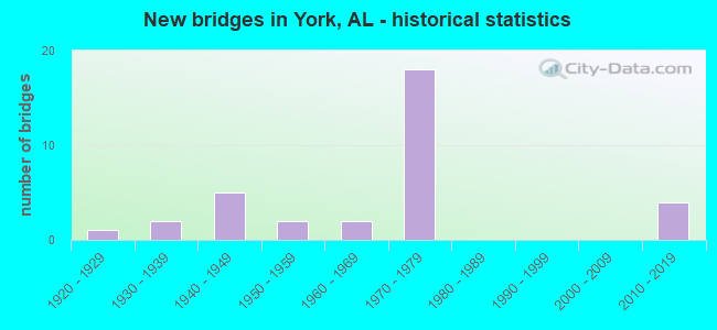
- New bridges - historical statistics
- 11920-1929
- 21930-1939
- 51940-1949
- 21950-1959
- 21960-1969
- 181970-1979
- 42010-2019

- Reconstructed bridges - Historical Statistics
- 11940-1949
- 01950-1959
- 01960-1969
- 01970-1979
- 01980-1989
- 01990-1999
- 12000-2009


- Bridge Condition - Deck
- 6.7%Very good
- 60.0%Good
- 26.7%Satisfactory
- 6.7%Fair

- Bridge Condition - Superstructure
- 6.7%Excellent
- 6.7%Very good
- 40.0%Good
- 33.3%Satisfactory
- 13.3%Fair

- Bridge Condition - Substructure
- 6.7%Very good
- 46.7%Good
- 26.7%Satisfactory
- 20.0%Fair

- Bridge Condition - Channel
- 16.7%Good
- 72.2%Satisfactory
- 11.1%Fair

- Bridge Condition - Culverts
- 16.7%Good
- 75.0%Satisfactory
- 8.3%Fair
Find on map >> Show street view
Structure Number: 175, Location: 1.0 MI. S.OF YORK (Lat: 32.474664, Lng: -88.290964), Route carried "on" structure: State highway 17, Year Built: 1938, Status: Open, Structure Length: 3.40m (11.15ft), Average Daily Traffic: 2,255 (year 2019), Truck Traffic: 12%, Average Future Daily Traffic: 3,695 (year 2039), Design Load: H 15, Features Intersected: ALAMUCHEE CREEK
Minimum Vertical Clearance: 30+ m (98+ ft), Kilometerpoint: 224.214, Lanes on structure: 2, Owner: State Highway Agency, Approaching Roadway Width: 9.1m (29.9ft), Material/Design: Steel continuous, Design/Construction: Stringer/Multi-beam, Number Of Spans In Main Unit: 5, Length of Maximum Span: 6.7m (22.0ft), Curb-To-Curb Width: 7.3m (24.0ft), Out-to-Out Width: 7.9m (25.9ft)
Condition: Deck: Satisfactory, Superstructure: Satisfactory, Substructure: Satisfactory, Channel: Satisfactory, Operating Rating: 49.9 metric tons, Method Used To Determine Operating Rating: Load Factor (LF), Inventory Rating: 29.8 metric tons, Method Used To Determine Inventory Rating: Load Factor (LF), Structural Evaluation: Equal to present minimum criteria, Deck Geometry: High priority of replacement, Waterway Adequacy: Equal to present minimum criteria, Approach Roadway Alignment: Equal to present desirable criteria, Length Of Structure Improvement: 4.29m (14.07ft), Designated Inspection Frequency: Every 24 months, Inspection Date: January 2021, Bridge Improvement Cost: $735,000, Roadway Improvement Cost: $74,000, Total Project Cost: $809,000 ( Estimate for 2022), Deck Structure Type: Concrete Cast-file-Place
Find on map >> Show street view
Structure Number: 2302, Location: 1.5 MI. N. OF YORK (Lat: 32.511075, Lng: -88.298922), Route carried "on" structure: State highway 17, Year Built: 1940, Status: Open, Structure Length: 0.61m (2.00ft), Average Daily Traffic: 2,780 (year 2013), Truck Traffic: 20%, Average Future Daily Traffic: 3,585 (year 2041), Design Load: H 15, Features Intersected: LITTLE WHITE OAK CREEK
Minimum Vertical Clearance: 30+ m (98+ ft), Kilometerpoint: 228.446, Lanes on structure: 2, Owner: State Highway Agency, Approaching Roadway Width: 8.8m (28.9ft), Material/Design: Concrete, Design/Construction: Culvert, Number Of Spans In Main Unit: 2, Length of Maximum Span: 3.0m (9.8ft)
Condition: Channel: Satisfactory, Culverts: Satisfactory, Operating Rating: 66.2 metric tons, Method Used To Determine Operating Rating: Load Factor (LF), Inventory Rating: 39.6 metric tons, Method Used To Determine Inventory Rating: Load Factor (LF), Structural Evaluation: Equal to present minimum criteria, Waterway Adequacy: Equal to present minimum criteria, Approach Roadway Alignment: Equal to present desirable criteria, Length Of Structure Improvement: 1.22m (4.00ft), Designated Inspection Frequency: Every 24 months, Inspection Date: January 2021, Bridge Improvement Cost: $394,000, Roadway Improvement Cost: $39,000, Total Project Cost: $433,000 ( Estimate for 2022)
Find on map >> Show street view
Structure Number: 2303, Location: 2.5 MI. N. OF YORK (Lat: 32.525417, Lng: -88.299161), Route carried "on" structure: State highway 17, Year Built: 1940, Status: Open, Structure Length: 0.91m (2.99ft), Average Daily Traffic: 800 (year 2013), Truck Traffic: 28%, Average Future Daily Traffic: 1,032 (year 2041), Design Load: H 15, Features Intersected: WHITE OAK BRANCH
Minimum Vertical Clearance: 30+ m (98+ ft), Kilometerpoint: 230.056, Lanes on structure: 2, Owner: State Highway Agency, Approaching Roadway Width: 8.2m (26.9ft), Material/Design: Concrete, Design/Construction: Culvert, Number Of Spans In Main Unit: 3, Length of Maximum Span: 3.0m (9.8ft)
Condition: Channel: Fair, Culverts: Satisfactory, Operating Rating: 88.9 metric tons, Method Used To Determine Operating Rating: Load Factor (LF), Inventory Rating: 88.9 metric tons, Method Used To Determine Inventory Rating: Load Factor (LF), Structural Evaluation: Equal to present minimum criteria, Waterway Adequacy: Somewhat better than minimum adequacy, Approach Roadway Alignment: Equal to present desirable criteria, Length Of Structure Improvement: 1.59m (5.22ft), Designated Inspection Frequency: Every 24 months, Inspection Date: January 2021, Bridge Improvement Cost: $513,000, Roadway Improvement Cost: $51,000, Total Project Cost: $564,000 ( Estimate for 2022)
Find on map >> Show street view
Structure Number: 2304, Location: 3.9 MI. N. OF YORK (Lat: 32.546292, Lng: -88.299561), Route carried "on" structure: State highway 17, Year Built: 1940, Status: Open, Structure Length: 0.91m (2.99ft), Average Daily Traffic: 800 (year 2013), Truck Traffic: 28%, Average Future Daily Traffic: 1,032 (year 2041), Design Load: H 15, Features Intersected: BEAR CREEK
Minimum Vertical Clearance: 30+ m (98+ ft), Kilometerpoint: 232.359, Lanes on structure: 2, Owner: State Highway Agency, Approaching Roadway Width: 8.5m (27.9ft), Material/Design: Concrete, Design/Construction: Culvert, Number Of Spans In Main Unit: 3, Length of Maximum Span: 3.0m (9.8ft)
Condition: Channel: Satisfactory, Culverts: Satisfactory, Operating Rating: 88.9 metric tons, Method Used To Determine Operating Rating: Load Factor (LF), Inventory Rating: 84.1 metric tons, Method Used To Determine Inventory Rating: Load Factor (LF), Structural Evaluation: Equal to present minimum criteria, Waterway Adequacy: Equal to present minimum criteria, Approach Roadway Alignment: Equal to present desirable criteria, Length Of Structure Improvement: 1.59m (5.22ft), Designated Inspection Frequency: Every 24 months, Inspection Date: January 2021, Bridge Improvement Cost: $421,000, Roadway Improvement Cost: $42,000, Total Project Cost: $463,000 ( Estimate for 2022)
Find on map >> Show street view
Structure Number: 2305, Location: 5 MI. N. OF YORK (Lat: 32.568261, Lng: -88.300608), Route carried "on" structure: State highway 17, Year Built: 1940, Status: Open, Structure Length: 0.68m (2.23ft), Average Daily Traffic: 800 (year 2013), Truck Traffic: 28%, Average Future Daily Traffic: 1,032 (year 2041), Design Load: H 15, Features Intersected: BAREBONE CREEK
Minimum Vertical Clearance: 30+ m (98+ ft), Kilometerpoint: 234.792, Lanes on structure: 2, Owner: State Highway Agency, Approaching Roadway Width: 8.2m (26.9ft), Material/Design: Concrete, Design/Construction: Culvert, Number Of Spans In Main Unit: 2, Length of Maximum Span: 3.0m (9.8ft)
Condition: Channel: Satisfactory, Culverts: Fair, Operating Rating: 88.9 metric tons, Method Used To Determine Operating Rating: Load Factor (LF), Inventory Rating: 88.9 metric tons, Method Used To Determine Inventory Rating: Load Factor (LF), Structural Evaluation: Somewhat better than minimum adequacy, Waterway Adequacy: Equal to present minimum criteria, Approach Roadway Alignment: Equal to present desirable criteria, Length Of Structure Improvement: 1.31m (4.30ft), Designated Inspection Frequency: Every 24 months, Inspection Date: January 2021, Bridge Improvement Cost: $333,000, Roadway Improvement Cost: $33,000, Total Project Cost: $366,000 ( Estimate for 2022)
Find on map >> Show street view
Structure Number: 2799, Location: 5.9 MI. S. OF LIVINGSTON (Lat: 32.519667, Lng: -88.264769), Route carried "on" structure: US 11, Year Built: 1925, Year Reconstructed: 1945, Status: Open, Structure Length: 1.86m (6.10ft), Average Daily Traffic: 2,930 (year 2013), Truck Traffic: 9%, Average Future Daily Traffic: 3,915 (year 2039), Design Load: H 20, Features Intersected: BEAR CREEK
Minimum Vertical Clearance: 30+ m (98+ ft), Kilometerpoint: 17.659, Lanes on structure: 2, Owner: State Highway Agency, Approaching Roadway Width: 13.1m (43.0ft), Material/Design: Concrete, Design/Construction: Tee Beam, Number Of Spans In Main Unit: 2, Length of Maximum Span: 9.1m (29.9ft), Curb-To-Curb Width: 8.2m (26.9ft), Out-to-Out Width: 9.1m (29.9ft)
Condition: Deck: Satisfactory, Superstructure: Satisfactory, Substructure: Fair, Channel: Satisfactory, Operating Rating: 56.0 metric tons, Method Used To Determine Operating Rating: Load Factor (LF), Inventory Rating: 33.5 metric tons, Method Used To Determine Inventory Rating: Load Factor (LF), Structural Evaluation: Somewhat better than minimum adequacy, Deck Geometry: High priority of corrective action, Waterway Adequacy: Better than present minimum criteria, Approach Roadway Alignment: Better than present minimum criteria, Length Of Structure Improvement: 2.58m (8.46ft), Designated Inspection Frequency: Every 24 months, Inspection Date: March 2021, Bridge Improvement Cost: $513,000, Roadway Improvement Cost: $51,000, Total Project Cost: $564,000 ( Estimate for 2022), Deck Structure Type: Concrete Cast-file-Place, Wearing Surface/Protective System: Wearing Surface: Bituminous
Find on map >> Show street view
Structure Number: 2909, Location: W CL OF YORK (Lat: 32.480478, Lng: -88.317633), Route carried "on" structure: US 11, Year Built: 1946, Status: Open, Structure Length: 11.82m (38.78ft), Average Daily Traffic: 2,070 (year 2020), Truck Traffic: 4%, Average Future Daily Traffic: 3,392 (year 2039), Design Load: H 20, Features Intersected: TOOMSUBA CREEK
Minimum Vertical Clearance: 30+ m (98+ ft), Kilometerpoint: 10.786, Lanes on structure: 2, Owner: State Highway Agency, Approaching Roadway Width: 11.9m (39.0ft), Material/Design: Steel, Design/Construction: Stringer/Multi-beam, Number Of Spans In Main Unit: 1, Number Of Approach Spans: 9, Length of Maximum Span: 24.9m (81.7ft), Curb-To-Curb Width: 7.9m (25.9ft), Out-to-Out Width: 8.8m (28.9ft)
Condition: Deck: Fair, Superstructure: Fair, Substructure: Fair, Channel: Fair, Operating Rating: 41.0 metric tons, Method Used To Determine Operating Rating: Load Factor (LF), Inventory Rating: 24.6 metric tons, Method Used To Determine Inventory Rating: Load Factor (LF), Structural Evaluation: Somewhat better than minimum adequacy, Deck Geometry: High priority of corrective action, Waterway Adequacy: Better than present minimum criteria, Approach Roadway Alignment: Equal to present minimum criteria, Length Of Structure Improvement: 12.68m (41.60ft), Designated Inspection Frequency: Every 24 months, Inspection Date: Febuary 2021, Bridge Improvement Cost: $2,435,000, Roadway Improvement Cost: $244,000, Total Project Cost: $2,679,000 ( Estimate for 2022), Deck Structure Type: Concrete Cast-file-Place
Find on map >> Show street view
Structure Number: 4406, Location: 0.7 MI NW US HWY 11 (Lat: 32.496272, Lng: -88.306461), Route carried "on" structure: County highway 1064, Year Built: 1952, Status: Posted for load, Structure Length: 3.84m (12.60ft), Average Daily Traffic: 195 (year 2021), Truck Traffic: 5%, Average Future Daily Traffic: 275 (year 2039), Design Load: H 15, Features Intersected: ST LO-SAN FR R, Facility Carried by Structure: CO RD 64
Minimum Vertical Clearance: 30+ m (98+ ft), Kilometerpoint: 0.000, Lanes on structure: 2, Owner: County Highway Agency, Approaching Roadway Width: 7.3m (24.0ft), Material/Design: Concrete, Design/Construction: Tee Beam, Number Of Spans In Main Unit: 3, Length of Maximum Span: 12.8m (42.0ft), Curb-To-Curb Width: 6.6m (21.7ft), Out-to-Out Width: 7.7m (25.3ft)
Condition: Deck: Good, Superstructure: Good, Substructure: Good, Operating Rating: 29.1 metric tons, Method Used To Determine Operating Rating: Load Factor (LF), Inventory Rating: 17.4 metric tons, Method Used To Determine Inventory Rating: Load Factor (LF), Structural Evaluation: Somewhat better than minimum adequacy, Deck Geometry: Meets minimum limits, Underclear: Meets minimum limits, Approach Roadway Alignment: Better than present minimum criteria, Bridge Posting: Required (Relationship of Operating Rating to Maximum Legal Load: 20.0 - 29.9% below), Length Of Structure Improvement: 4.78m (15.68ft), Designated Inspection Frequency: Every 24 months, Other Special Inspection Frequency: Every 12 months, Inspection Date: August 2021, Other Special Inspection Date: August 2021, Bridge Improvement Cost: $819,000, Roadway Improvement Cost: $82,000, Total Project Cost: $901,000 ( Estimate for 2022), Deck Structure Type: Concrete Cast-file-Place
Find on map >> Show street view
Structure Number: 4793, Location: 1.5 MI.W. OF JCT. AL 17 (Lat: 32.437750, Lng: -88.289508), Route carried "on" structure: US 8, Year Built: 1954, Year Reconstructed: 2011, Status: Open, Structure Length: 0.63m (2.07ft), Average Daily Traffic: 2,950 (year 2013), Truck Traffic: 35%, Average Future Daily Traffic: 3,857 (year 2040), Design Load: H 15, Features Intersected: BUCK CREEK
Minimum Vertical Clearance: 30+ m (98+ ft), Kilometerpoint: 10.046, Lanes on structure: 4, Base Highway Network: Yes, Owner: State Highway Agency, Approaching Roadway Width: 9.7m (31.8ft), Skew: 3 degrees, Material/Design: Concrete, Design/Construction: Culvert, Number Of Spans In Main Unit: 2, Length of Maximum Span: 3.0m (9.8ft)
Condition: Channel: Good, Culverts: Satisfactory, Operating Rating: 88.9 metric tons, Method Used To Determine Operating Rating: Load Factor (LF), Inventory Rating: 88.9 metric tons, Method Used To Determine Inventory Rating: Load Factor (LF), Structural Evaluation: Equal to present minimum criteria, Waterway Adequacy: Better than present minimum criteria, Approach Roadway Alignment: Equal to present desirable criteria, Length Of Structure Improvement: 1.25m (4.10ft), Designated Inspection Frequency: Every 24 months, Inspection Date: October 2020, Bridge Improvement Cost: $1,637,000, Roadway Improvement Cost: $164,000, Total Project Cost: $1,801,000 ( Estimate for 2022)
Find on map >> Show street view
Structure Number: 7439, Location: 3.3 MI E MISS LINE (Lat: 32.495000, Lng: -88.345000), Route carried "on" structure: County highway 1061, Year Built: 1961, Status: Open, Structure Length: 1.28m (4.20ft), Average Daily Traffic: 420 (year 2018), Truck Traffic: 8%, Average Future Daily Traffic: 625 (year 2037), Design Load: H 15, Features Intersected: CO RT 1061 BRANCH, Facility Carried by Structure: ROADWAY
Minimum Vertical Clearance: 30+ m (98+ ft), Kilometerpoint: 0.000, Lanes on structure: 2, Owner: County Highway Agency, Approaching Roadway Width: 6.7m (22.0ft), Skew: 3 degrees, Material/Design: Concrete, Design/Construction: Culvert, Number Of Spans In Main Unit: 3, Length of Maximum Span: 2.7m (8.9ft)
Condition: Channel: Good, Culverts: Good, Operating Rating: 88.9 metric tons, Method Used To Determine Operating Rating: Load Factor (LF), Inventory Rating: 54.0 metric tons, Method Used To Determine Inventory Rating: Load Factor (LF), Structural Evaluation: Better than present minimum criteria, Waterway Adequacy: Equal to present minimum criteria, Approach Roadway Alignment: Equal to present desirable criteria, Length Of Structure Improvement: 1.95m (6.40ft), Designated Inspection Frequency: Every 24 months, Inspection Date: April 2020, Bridge Improvement Cost: $474,000, Roadway Improvement Cost: $47,000, Total Project Cost: $521,000 ( Estimate for 2022), Wearing Surface/Protective System: Wearing Surface: Bituminous
Find on map >> Show street view
Structure Number: 744, Location: 4.0 MI E MISS LINE (Lat: 32.490000, Lng: -88.335000), Route carried "on" structure: County highway 1061, Year Built: 1961, Status: Open, Structure Length: 0.88m (2.89ft), Average Daily Traffic: 420 (year 2020), Truck Traffic: 8%, Average Future Daily Traffic: 625 (year 2039), Design Load: H 15, Features Intersected: CO RT 1061 BRANCH, Facility Carried by Structure: ROADWAY
Minimum Vertical Clearance: 30+ m (98+ ft), Kilometerpoint: 0.000, Lanes on structure: 2, Owner: County Highway Agency, Approaching Roadway Width: 6.7m (22.0ft), Material/Design: Concrete, Design/Construction: Culvert, Number Of Spans In Main Unit: 2, Length of Maximum Span: 3.0m (9.8ft)
Condition: Channel: Good, Culverts: Good, Operating Rating: 40.8 metric tons, Method Used To Determine Operating Rating: Load Factor (LF), Inventory Rating: 24.5 metric tons, Method Used To Determine Inventory Rating: Load Factor (LF), Structural Evaluation: Equal to present minimum criteria, Waterway Adequacy: Superior to present desirable criteria, Approach Roadway Alignment: Equal to present desirable criteria, Length Of Structure Improvement: 1.55m (5.09ft), Designated Inspection Frequency: Every 24 months, Inspection Date: April 2020, Bridge Improvement Cost: $260,000, Roadway Improvement Cost: $26,000, Total Project Cost: $286,000 ( Estimate for 2022), Wearing Surface/Protective System: Wearing Surface: Bituminous
Find on map >> Show street view
Structure Number: 10351, Location: 2.5 MI SE US HWY 11 (Lat: 32.450403, Lng: -88.307058), Route carried "on" structure: County highway 1049, Year Built: 1970, Status: Posted for load, Structure Length: 1.46m (4.79ft), Average Daily Traffic: 36 (year 2019), Average Future Daily Traffic: 54 (year 2038), Design Load: H 15, Features Intersected: CO RT 1049 STREAM, Facility Carried by Structure: ROADWAY
Minimum Vertical Clearance: 30+ m (98+ ft), Kilometerpoint: 0.000, Lanes on structure: 2, Owner: County Highway Agency, Approaching Roadway Width: 6.7m (22.0ft), Material/Design: Concrete, Design/Construction: Channel Beam, Number Of Spans In Main Unit: 3, Length of Maximum Span: 4.9m (16.1ft), Curb-To-Curb Width: 5.8m (19.0ft), Out-to-Out Width: 6.4m (21.0ft)
Condition: Deck: Satisfactory, Superstructure: Satisfactory, Substructure: Fair, Channel: Satisfactory, Operating Rating: 36.1 metric tons, Method Used To Determine Operating Rating: Allowable Stress (AS), Inventory Rating: 23.0 metric tons, Method Used To Determine Inventory Rating: Allowable Stress (AS), Structural Evaluation: Somewhat better than minimum adequacy, Deck Geometry: Meets minimum limits, Waterway Adequacy: Better than present minimum criteria, Approach Roadway Alignment: Equal to present minimum criteria, Bridge Posting: Required (Relationship of Operating Rating to Maximum Legal Load: 10.0 - 19.9% below), Length Of Structure Improvement: 2.14m (7.02ft), Designated Inspection Frequency: Every 24 months, Other Special Inspection Frequency: Every 12 months, Inspection Date: July 2021, Other Special Inspection Date: July 2021, Bridge Improvement Cost: $308,000, Roadway Improvement Cost: $31,000, Total Project Cost: $339,000 ( Estimate for 2022), Deck Structure Type: Concrete Precast Panels
Find on map >> Show street view
Structure Number: 1087, Location: 1.3 MI. N. OF SR 17 (Lat: 32.535119, Lng: -88.285258), Route carried "on" structure: Interstate 59, Year Built: 1973, Status: Open, Structure Length: 1.04m (3.41ft), Average Daily Traffic: 20,946 (year 2020), Truck Traffic: 44%, Average Future Daily Traffic: 34,322 (year 2040), Design Load: HS 20, Features Intersected: BEAR CREEK
Minimum Vertical Clearance: 30+ m (98+ ft), Kilometerpoint: 14.911, Lanes on structure: 4, Base Highway Network: Yes, Owner: State Highway Agency, Approaching Roadway Width: 13.4m (44.0ft), Skew: 21 degrees, Material/Design: Concrete, Design/Construction: Culvert, Number Of Spans In Main Unit: 3, Length of Maximum Span: 3.0m (9.8ft)
Condition: Channel: Satisfactory, Culverts: Satisfactory, Operating Rating: 88.9 metric tons, Method Used To Determine Operating Rating: Load Factor (LF), Inventory Rating: 88.9 metric tons, Method Used To Determine Inventory Rating: Load Factor (LF), Structural Evaluation: Equal to present minimum criteria, Waterway Adequacy: Better than present minimum criteria, Approach Roadway Alignment: Equal to present desirable criteria, Length Of Structure Improvement: 1.71m (5.61ft), Designated Inspection Frequency: Every 24 months, Inspection Date: April 2021, Bridge Improvement Cost: $4,549,000, Roadway Improvement Cost: $455,000, Total Project Cost: $5,004,000 ( Estimate for 2022)
Find on map >> Show street view
Structure Number: 10871, Location: 2.5 MI. N. OF S.R. 17 (Lat: 32.548636, Lng: -88.272242), Route carried "on" structure: Interstate 59, Year Built: 1973, Status: Open, Structure Length: 0.99m (3.25ft), Average Daily Traffic: 20,946 (year 2020), Truck Traffic: 44%, Average Future Daily Traffic: 34,322 (year 2040), Design Load: HS 20, Features Intersected: PARKER CREEK
Minimum Vertical Clearance: 30+ m (98+ ft), Kilometerpoint: 16.834, Lanes on structure: 4, Base Highway Network: Yes, Owner: State Highway Agency, Approaching Roadway Width: 13.4m (44.0ft), Skew: 20 degrees, Material/Design: Concrete, Design/Construction: Culvert, Number Of Spans In Main Unit: 3, Length of Maximum Span: 3.0m (9.8ft)
Condition: Channel: Satisfactory, Culverts: Satisfactory, Operating Rating: 88.9 metric tons, Method Used To Determine Operating Rating: Load Factor (LF), Inventory Rating: 88.9 metric tons, Method Used To Determine Inventory Rating: Load Factor (LF), Structural Evaluation: Equal to present minimum criteria, Waterway Adequacy: Equal to present minimum criteria, Approach Roadway Alignment: Equal to present desirable criteria, Length Of Structure Improvement: 1.66m (5.45ft), Designated Inspection Frequency: Every 24 months, Inspection Date: April 2021, Bridge Improvement Cost: $3,419,000, Roadway Improvement Cost: $342,000, Total Project Cost: $3,761,000 ( Estimate for 2022)
Find on map >> Show street view
Structure Number: 11101, Location: 4.4MI.N.OF MISS.ST.LINE (Lat: 32.487775, Lng: -88.346572), Route carried "on" structure: Interstate 59, Year Built: 1974, Status: Open, Structure Length: 9.33m (30.61ft), Average Daily Traffic: 9,020 (year 2013), Truck Traffic: 44%, Average Future Daily Traffic: 10,370 (year 2039), Design Load: HS 20, Features Intersected: SWEETWATER CREEK
Minimum Vertical Clearance: 30+ m (98+ ft), Kilometerpoint: 7.079, Lanes on structure: 2, Base Highway Network: Yes, Owner: State Highway Agency, Approaching Roadway Width: 13.4m (44.0ft), Material/Design: Concrete, Design/Construction: Tee Beam, Number Of Spans In Main Unit: 9, Length of Maximum Span: 10.4m (34.1ft), Curb-To-Curb Width: 11.9m (39.0ft), Out-to-Out Width: 12.4m (40.7ft)
Condition: Deck: Good, Superstructure: Satisfactory, Substructure: Satisfactory, Channel: Satisfactory, Operating Rating: 45.0 metric tons, Method Used To Determine Operating Rating: Load Factor (LF), Inventory Rating: 27.0 metric tons, Method Used To Determine Inventory Rating: Load Factor (LF), Structural Evaluation: Equal to present minimum criteria, Deck Geometry: Equal to present minimum criteria, Waterway Adequacy: Better than present minimum criteria, Approach Roadway Alignment: Equal to present desirable criteria, Length Of Structure Improvement: 10.29m (33.76ft), Designated Inspection Frequency: Every 24 months, Inspection Date: April 2021, Bridge Improvement Cost: $2,822,000, Roadway Improvement Cost: $282,000, Total Project Cost: $3,104,000 ( Estimate for 2022), Deck Structure Type: Concrete Cast-file-Place
Find on map >> Show street view
Structure Number: 11102, Location: 4.4 MI.N.OF MISS.ST.LINE (Lat: 32.487625, Lng: -88.346281), Route carried "on" structure: Interstate 59, Year Built: 1974, Status: Open, Structure Length: 9.33m (30.61ft), Average Daily Traffic: 9,020 (year 2013), Truck Traffic: 44%, Average Future Daily Traffic: 10,370 (year 2039), Design Load: HS 20, Features Intersected: SWEETWATER CREEK
Minimum Vertical Clearance: 30+ m (98+ ft), Kilometerpoint: 7.079, Lanes on structure: 2, Base Highway Network: Yes, Owner: State Highway Agency, Approaching Roadway Width: 13.4m (44.0ft), Material/Design: Concrete, Design/Construction: Tee Beam, Number Of Spans In Main Unit: 9, Length of Maximum Span: 10.4m (34.1ft), Curb-To-Curb Width: 11.9m (39.0ft), Out-to-Out Width: 12.4m (40.7ft)
Condition: Deck: Good, Superstructure: Fair, Substructure: Satisfactory, Channel: Satisfactory, Operating Rating: 45.0 metric tons, Method Used To Determine Operating Rating: Load Factor (LF), Inventory Rating: 27.0 metric tons, Method Used To Determine Inventory Rating: Load Factor (LF), Structural Evaluation: Somewhat better than minimum adequacy, Deck Geometry: Equal to present minimum criteria, Waterway Adequacy: Better than present minimum criteria, Approach Roadway Alignment: Equal to present desirable criteria, Length Of Structure Improvement: 10.29m (33.76ft), Designated Inspection Frequency: Every 24 months, Inspection Date: April 2021, Bridge Improvement Cost: $2,822,000, Roadway Improvement Cost: $282,000, Total Project Cost: $3,104,000 ( Estimate for 2022), Deck Structure Type: Concrete Cast-file-Place
Find on map >> Show street view
Structure Number: 11103, Location: 4.6 MI.N.OF MISS.ST.LINE (Lat: 32.490672, Lng: -88.343597), Route carried "on" structure: Interstate 59, Year Built: 1974, Status: Open, Structure Length: 0.79m (2.59ft), Average Daily Traffic: 19,886 (year 2019), Truck Traffic: 44%, Average Future Daily Traffic: 20,741 (year 2041), Design Load: HS 20, Features Intersected: UT SWEETWATER CREEK
Minimum Vertical Clearance: 30+ m (98+ ft), Kilometerpoint: 7.461, Lanes on structure: 4, Base Highway Network: Yes, Owner: State Highway Agency, Approaching Roadway Width: 13.4m (44.0ft), Material/Design: Concrete, Design/Construction: Culvert, Number Of Spans In Main Unit: 2, Length of Maximum Span: 3.7m (12.1ft)
Condition: Channel: Satisfactory, Culverts: Satisfactory, Operating Rating: 43.2 metric tons, Method Used To Determine Operating Rating: Load Factor (LF), Inventory Rating: 25.9 metric tons, Method Used To Determine Inventory Rating: Load Factor (LF), Structural Evaluation: Equal to present minimum criteria, Waterway Adequacy: Equal to present minimum criteria, Approach Roadway Alignment: Equal to present desirable criteria, Length Of Structure Improvement: 1.44m (4.72ft), Designated Inspection Frequency: Every 24 months, Inspection Date: March 2021, Bridge Improvement Cost: $1,617,000, Roadway Improvement Cost: $162,000, Total Project Cost: $1,779,000 ( Estimate for 2022)
Find on map >> Show street view
Structure Number: 11104, Location: 4.7MI.N.OF MISS.ST.LINE (Lat: 32.491567, Lng: -88.342933), Route carried "on" structure: County highway 2, Year Built: 1974, Status: Open, Structure Length: 9.69m (31.79ft), Average Daily Traffic: 100 (year 2000), Average Future Daily Traffic: 150 (year 2035), Design Load: HS 20, Features Intersected: I-59
Minimum Vertical Clearance: 30+ m (98+ ft), Kilometerpoint: 0.000, Lanes on structure: 2, Lanes under structure: 4, Owner: State Highway Agency, Approaching Roadway Width: 10.1m (33.1ft), Material/Design: Concrete continuous, Design/Construction: Tee Beam, Number Of Spans In Main Unit: 2, Number Of Approach Spans: 2, Length of Maximum Span: 26.5m (86.9ft), Curb-To-Curb Width: 8.5m (27.9ft), Out-to-Out Width: 9.0m (29.5ft)
Condition: Deck: Satisfactory, Superstructure: Good, Substructure: Good, Operating Rating: 65.9 metric tons, Method Used To Determine Operating Rating: Load Factor (LF), Inventory Rating: 39.5 metric tons, Method Used To Determine Inventory Rating: Load Factor (LF), Structural Evaluation: Better than present minimum criteria, Deck Geometry: Better than present minimum criteria, Underclear: Equal to present minimum criteria, Approach Roadway Alignment: Equal to present minimum criteria, Length Of Structure Improvement: 10.63m (34.88ft), Designated Inspection Frequency: Every 24 months, Inspection Date: March 2021, Bridge Improvement Cost: $2,114,000, Roadway Improvement Cost: $211,000, Total Project Cost: $2,325,000 ( Estimate for 2022), Deck Structure Type: Concrete Cast-file-Place
Find on map >> Show street view
Structure Number: 11105, Location: 6.5 MI N OF MISS ST LINE (Lat: 32.509536, Lng: -88.320975), Route carried "on" structure: County highway 19, Year Built: 1974, Status: Open, Structure Length: 9.57m (31.40ft), Average Daily Traffic: 112 (year 2019), Truck Traffic: 12%, Average Future Daily Traffic: 184 (year 2039), Design Load: HS 20, Features Intersected: I-20/59
Minimum Vertical Clearance: 30+ m (98+ ft), Kilometerpoint: 0.000, Lanes on structure: 2, Lanes under structure: 4, Owner: State Highway Agency, Approaching Roadway Width: 10.1m (33.1ft), Material/Design: Steel continuous, Design/Construction: Stringer/Multi-beam, Number Of Spans In Main Unit: 2, Number Of Approach Spans: 2, Length of Maximum Span: 26.5m (86.9ft), Curb-To-Curb Width: 8.5m (27.9ft), Out-to-Out Width: 9.0m (29.5ft)
Condition: Deck: Good, Superstructure: Good, Substructure: Good, Operating Rating: 64.7 metric tons, Method Used To Determine Operating Rating: Load Factor (LF), Inventory Rating: 38.7 metric tons, Method Used To Determine Inventory Rating: Load Factor (LF), Structural Evaluation: Better than present minimum criteria, Deck Geometry: Equal to present minimum criteria, Underclear: Equal to present desirable criteria, Approach Roadway Alignment: Equal to present minimum criteria, Length Of Structure Improvement: 10.52m (34.51ft), Designated Inspection Frequency: Every 24 months, Inspection Date: March 2021, Bridge Improvement Cost: $2,092,000, Roadway Improvement Cost: $209,000, Total Project Cost: $2,301,000 ( Estimate for 2022), Deck Structure Type: Concrete Cast-file-Place
Find on map >> Show street view
Structure Number: 11106, Location: 7.5MI.N.OF MISS.ST.LINE (Lat: 32.517447, Lng: -88.307728), Route carried "on" structure: Interstate 59, Year Built: 1974, Status: Open, Structure Length: 0.89m (2.92ft), Average Daily Traffic: 18,188 (year 2020), Truck Traffic: 44%, Average Future Daily Traffic: 29,803 (year 2040), Design Load: HS 20, Features Intersected: WHITE OAK CREEK
Minimum Vertical Clearance: 30+ m (98+ ft), Kilometerpoint: 12.012, Lanes on structure: 4, Base Highway Network: Yes, Owner: State Highway Agency, Approaching Roadway Width: 13.4m (44.0ft), Skew: 21 degrees, Material/Design: Concrete, Design/Construction: Culvert, Number Of Spans In Main Unit: 3, Length of Maximum Span: 2.7m (8.9ft)
Condition: Channel: Satisfactory, Culverts: Satisfactory, Operating Rating: 88.9 metric tons, Method Used To Determine Operating Rating: Load Factor (LF), Inventory Rating: 88.9 metric tons, Method Used To Determine Inventory Rating: Load Factor (LF), Structural Evaluation: Equal to present minimum criteria, Waterway Adequacy: Better than present minimum criteria, Approach Roadway Alignment: Equal to present desirable criteria, Length Of Structure Improvement: 1.56m (5.12ft), Designated Inspection Frequency: Every 24 months, Inspection Date: April 2021, Bridge Improvement Cost: $2,355,000, Roadway Improvement Cost: $236,000, Total Project Cost: $2,591,000 ( Estimate for 2022)
Find on map >> Show street view
Structure Number: 11107, Location: .3MI.S.OF S.R.17 (Lat: 32.519967, Lng: -88.303614), Route carried "on" structure: Interstate 59, Year Built: 1974, Status: Open, Structure Length: 6.21m (20.37ft), Average Daily Traffic: 9,020 (year 2013), Truck Traffic: 44%, Average Future Daily Traffic: 10,370 (year 2033), Design Load: HS 20, Features Intersected: AT*N.RR (ABANDON)
Minimum Vertical Clearance: 30+ m (98+ ft), Kilometerpoint: 12.445, Lanes on structure: 2, Base Highway Network: Yes, Owner: State Highway Agency, Approaching Roadway Width: 13.4m (44.0ft), Skew: 3 degrees, Material/Design: Steel continuous, Design/Construction: Stringer/Multi-beam, Number Of Spans In Main Unit: 1, Number Of Approach Spans: 2, Length of Maximum Span: 24.4m (80.1ft), Curb-To-Curb Width: 15.6m (51.2ft), Out-to-Out Width: 16.1m (52.8ft)
Condition: Deck: Good, Superstructure: Good, Substructure: Good, Operating Rating: 56.1 metric tons, Method Used To Determine Operating Rating: Load Factor (LF), Inventory Rating: 33.6 metric tons, Method Used To Determine Inventory Rating: Load Factor (LF), Structural Evaluation: Better than present minimum criteria, Deck Geometry: Superior to present desirable criteria, Underclear: Superior to present desirable criteria, Approach Roadway Alignment: Better than present minimum criteria, Length Of Structure Improvement: 7.25m (23.79ft), Designated Inspection Frequency: Every 24 months, Inspection Date: April 2021, Bridge Improvement Cost: $2,585,000, Roadway Improvement Cost: $259,000, Total Project Cost: $2,844,000 ( Estimate for 2022), Deck Structure Type: Concrete Cast-file-Place
Find on map >> Show street view
Structure Number: 11108, Location: .3MI.S. OF S.R.17 (Lat: 32.519522, Lng: -88.303503), Route carried "on" structure: Interstate 59, Year Built: 1974, Status: Open, Structure Length: 6.21m (20.37ft), Average Daily Traffic: 9,020 (year 2013), Truck Traffic: 44%, Average Future Daily Traffic: 10,370 (year 2033), Design Load: HS 20, Features Intersected: AT*N.RR (ABANDON)
Minimum Vertical Clearance: 30+ m (98+ ft), Kilometerpoint: 12.445, Lanes on structure: 2, Base Highway Network: Yes, Owner: State Highway Agency, Approaching Roadway Width: 13.4m (44.0ft), Skew: 3 degrees, Material/Design: Steel continuous, Design/Construction: Stringer/Multi-beam, Number Of Spans In Main Unit: 1, Number Of Approach Spans: 2, Length of Maximum Span: 24.4m (80.1ft), Curb-To-Curb Width: 15.6m (51.2ft), Out-to-Out Width: 16.1m (52.8ft)
Condition: Deck: Good, Superstructure: Good, Substructure: Good, Operating Rating: 56.1 metric tons, Method Used To Determine Operating Rating: Load Factor (LF), Inventory Rating: 33.6 metric tons, Method Used To Determine Inventory Rating: Load Factor (LF), Structural Evaluation: Better than present minimum criteria, Deck Geometry: Superior to present desirable criteria, Underclear: Superior to present desirable criteria, Approach Roadway Alignment: Better than present minimum criteria, Length Of Structure Improvement: 7.25m (23.79ft), Designated Inspection Frequency: Every 24 months, Inspection Date: April 2021, Bridge Improvement Cost: $2,585,000, Roadway Improvement Cost: $259,000, Total Project Cost: $2,844,000 ( Estimate for 2022), Deck Structure Type: Concrete Cast-file-Place
Find on map >> Show street view
Structure Number: 11109, Location: .4 MI. N. OF S.R. 17 (Lat: 32.525556, Lng: -88.294144), Route carried "on" structure: Interstate 59, Year Built: 1974, Status: Open, Structure Length: 0.79m (2.59ft), Average Daily Traffic: 20,946 (year 2020), Truck Traffic: 44%, Average Future Daily Traffic: 34,322 (year 2040), Design Load: HS 20, Features Intersected: White Hall Creek
Minimum Vertical Clearance: 30+ m (98+ ft), Kilometerpoint: 13.549, Lanes on structure: 4, Base Highway Network: Yes, Owner: State Highway Agency, Approaching Roadway Width: 13.4m (44.0ft), Skew: 20 degrees, Material/Design: Concrete, Design/Construction: Culvert, Number Of Spans In Main Unit: 2, Length of Maximum Span: 3.7m (12.1ft)
Condition: Channel: Satisfactory, Culverts: Satisfactory, Operating Rating: 88.9 metric tons, Method Used To Determine Operating Rating: Load Factor (LF), Inventory Rating: 88.9 metric tons, Method Used To Determine Inventory Rating: Load Factor (LF), Structural Evaluation: Equal to present minimum criteria, Waterway Adequacy: Better than present minimum criteria, Approach Roadway Alignment: Equal to present desirable criteria, Length Of Structure Improvement: 1.44m (4.72ft), Designated Inspection Frequency: Every 24 months, Inspection Date: April 2021, Bridge Improvement Cost: $2,209,000, Roadway Improvement Cost: $221,000, Total Project Cost: $2,430,000 ( Estimate for 2022)
Find on map >> Show street view
Structure Number: 1111, Location: 3 MI. N. OF S.R. 17 (Lat: 32.554519, Lng: -88.266078), Route carried "on" structure: County highway 19, Year Built: 1974, Status: Open, Structure Length: 11.52m (37.80ft), Average Daily Traffic: 100 (year 2000), Average Future Daily Traffic: 150 (year 2028), Design Load: HS 20, Features Intersected: I 59
Minimum Vertical Clearance: 30+ m (98+ ft), Kilometerpoint: 0.000, Lanes on structure: 2, Lanes under structure: 4, Owner: State Highway Agency, Approaching Roadway Width: 13.4m (44.0ft), Material/Design: Concrete continuous, Design/Construction: Tee Beam, Number Of Spans In Main Unit: 2, Number Of Approach Spans: 2, Length of Maximum Span: 32.0m (105.0ft), Curb-To-Curb Width: 8.5m (27.9ft), Out-to-Out Width: 8.8m (28.9ft)
Condition: Deck: Good, Superstructure: Satisfactory, Substructure: Satisfactory, Operating Rating: 60.6 metric tons, Method Used To Determine Operating Rating: Load Factor (LF), Inventory Rating: 36.3 metric tons, Method Used To Determine Inventory Rating: Load Factor (LF), Structural Evaluation: Equal to present minimum criteria, Deck Geometry: Better than present minimum criteria, Underclear: Better than present minimum criteria, Approach Roadway Alignment: Somewhat better than minimum adequacy, Length Of Structure Improvement: 12.39m (40.65ft), Designated Inspection Frequency: Every 24 months, Inspection Date: April 2021, Bridge Improvement Cost: $2,379,000, Roadway Improvement Cost: $238,000, Total Project Cost: $2,617,000 ( Estimate for 2022), Deck Structure Type: Concrete Cast-file-Place
Find on map >> Show street view
Structure Number: 11206, Location: 2.3 MI. N. OF YORK (Lat: 32.521758, Lng: -88.299108), Route carried "on" structure: State highway 17, Year Built: 1974, Status: Open, Structure Length: 11.66m (38.25ft), Average Daily Traffic: 2,780 (year 2013), Truck Traffic: 20%, Average Future Daily Traffic: 3,585 (year 2033), Design Load: HS 20, Features Intersected: I-59
Minimum Vertical Clearance: 30+ m (98+ ft), Kilometerpoint: 229.616, Lanes on structure: 2, Lanes under structure: 4, Owner: State Highway Agency, Approaching Roadway Width: 13.7m (44.9ft), Skew: 3 degrees, Material/Design: Concrete continuous, Design/Construction: Tee Beam, Number Of Spans In Main Unit: 2, Number Of Approach Spans: 2, Length of Maximum Span: 32.0m (105.0ft), Curb-To-Curb Width: 13.4m (44.0ft), Out-to-Out Width: 13.9m (45.6ft)
Condition: Deck: Good, Superstructure: Good, Substructure: Good, Operating Rating: 47.5 metric tons, Method Used To Determine Operating Rating: Load Factor (LF), Inventory Rating: 28.4 metric tons, Method Used To Determine Inventory Rating: Load Factor (LF), Structural Evaluation: Better than present minimum criteria, Deck Geometry: Better than present minimum criteria, Underclear: Somewhat better than minimum adequacy, Approach Roadway Alignment: Equal to present desirable criteria, Length Of Structure Improvement: 12.52m (41.08ft), Designated Inspection Frequency: Every 24 months, Inspection Date: January 2021, Bridge Improvement Cost: $3,864,000, Roadway Improvement Cost: $386,000, Total Project Cost: $4,250,000 ( Estimate for 2022), Deck Structure Type: Concrete Cast-file-Place
Find on map >> Show street view
Structure Number: 19667, Location: 7.8 east of Miss. Line (Lat: 32.442550, Lng: -88.263928), Route carried "on" structure: US 8, Year Built: 2010, Status: Open, Structure Length: 7.80m (25.59ft), Average Daily Traffic: 4,752 (year 2020), Truck Traffic: 17%, Average Future Daily Traffic: 7,787 (year 2040), Design Load: HS 20, Features Intersected: SR 17
Minimum Vertical Clearance: 30+ m (98+ ft), Kilometerpoint: 12.540, Lanes on structure: 2, Lanes under structure: 3, Base Highway Network: Yes, Owner: State Highway Agency, Approaching Roadway Width: 11.6m (38.1ft), Material/Design: Prestressed concrete, Design/Construction: Stringer/Multi-beam, Number Of Spans In Main Unit: 3, Length of Maximum Span: 36.6m (120.1ft), Curb-To-Curb Width: 12.2m (40.0ft), Out-to-Out Width: 13.0m (42.7ft)
Condition: Deck: Very good, Superstructure: Excellent, Substructure: Very good, Operating Rating: 88.9 metric tons, Method Used To Determine Operating Rating: Load Factor (LF), Inventory Rating: 35.7 metric tons, Method Used To Determine Inventory Rating: Load Factor (LF), Structural Evaluation: Equal to present desirable criteria, Deck Geometry: Better than present minimum criteria, Approach Roadway Alignment: Equal to present desirable criteria, Length Of Structure Improvement: 8.82m (28.94ft), Designated Inspection Frequency: Every 24 months, Inspection Date: April 2021, Bridge Improvement Cost: $2,539,000, Roadway Improvement Cost: $254,000, Total Project Cost: $2,793,000 ( Estimate for 2022), Deck Structure Type: Concrete Cast-file-Place
Find on map >> Show street view
Structure Number: 19674, Location: 6.5 MI WEST OF CUBA (Lat: 32.442847, Lng: -88.263839), Route carried "on" structure: US 8, Year Built: 2012, Status: Open, Structure Length: 7.80m (25.59ft), Average Daily Traffic: 1,475 (year 2013), Truck Traffic: 35%, Average Future Daily Traffic: 1,928 (year 2033), Design Load: HS 20, Features Intersected: SR 17 OVERPASS
Minimum Vertical Clearance: 5.52m (18.11ft), Kilometerpoint: 12.540, Lanes on structure: 2, Lanes under structure: 2, Base Highway Network: Yes, Owner: State Highway Agency, Approaching Roadway Width: 17.4m (57.1ft), Material/Design: Prestressed concrete, Design/Construction: Stringer/Multi-beam, Number Of Spans In Main Unit: 3, Length of Maximum Span: 36.6m (120.1ft), Curb-To-Curb Width: 15.8m (51.8ft), Out-to-Out Width: 16.7m (54.8ft)
Condition: Deck: Good, Superstructure: Very good, Substructure: Good, Operating Rating: 83.5 metric tons, Method Used To Determine Operating Rating: Load Factor (LF), Inventory Rating: 31.9 metric tons, Method Used To Determine Inventory Rating: Load Factor (LF), Structural Evaluation: Better than present minimum criteria, Deck Geometry: Superior to present desirable criteria, Underclear: Superior to present desirable criteria, Approach Roadway Alignment: Superior to present desirable criteria, Length Of Structure Improvement: 8.82m (28.94ft), Designated Inspection Frequency: Every 24 months, Inspection Date: December 2020, Bridge Improvement Cost: $3,265,000, Roadway Improvement Cost: $327,000, Total Project Cost: $3,592,000 ( Estimate for 2022), Deck Structure Type: Concrete Cast-file-Place
Find on map >> Show street view
Structure Number: 1417, Location: YORK (Lat: 32.486667, Lng: -88.305000), Route carried "under" structure: US 11, Year Built: 1936, Structure Length: 0. m, Average Daily Traffic: 4,940 (year 2013), Truck Traffic: 7%, Features Intersected: US 11, Facility Carried by Structure: A.T.*N. R.R.
Minimum Vertical Clearance: 4.29m (14.07ft), Kilometerpoint: 12.194, Lanes under structure: 20, Material/Design: Concrete, Design/Construction: Slab, Length of Maximum Span: 14.9m (48.9ft)
Find on map >> Show street view
Structure Number: 11104, Location: 4.7MI.N.OF MISS.ST.LINE (Lat: 32.491567, Lng: -88.342933), Route carried "under" structure: Interstate 20, Year Built: 1974, Structure Length: 0. m, Average Daily Traffic: 18,040 (year 2013), Truck Traffic: 44%, Features Intersected: I-59, Facility Carried by Structure: COUNTY ROUTE 2
Minimum Vertical Clearance: 5.41m (17.75ft), Kilometerpoint: 7.586, Lanes on structure: 2, Lanes under structure: 4, Material/Design: Concrete continuous, Design/Construction: Tee Beam, Length of Maximum Span: 26.5m (86.9ft)
Find on map >> Show street view
Structure Number: 11105, Location: 6.5 MI N OF MISS ST LINE (Lat: 32.509536, Lng: -88.320975), Route carried "under" structure: Interstate 20, Year Built: 1974, Structure Length: 0. m, Average Daily Traffic: 18,040 (year 2013), Truck Traffic: 44%, Features Intersected: I-20/59, Facility Carried by Structure: CR 19
Minimum Vertical Clearance: 5.21m (17.09ft), Kilometerpoint: 10.469, Lanes on structure: 2, Lanes under structure: 4, Material/Design: Steel continuous, Design/Construction: Stringer/Multi-beam, Length of Maximum Span: 26.5m (86.9ft)
Find on map >> Show street view
Structure Number: 1111, Location: 3 MI. N. OF S.R. 17 (Lat: 32.554519, Lng: -88.266078), Route carried "under" structure: Interstate 20, Year Built: 1974, Structure Length: 0. m, Average Daily Traffic: 20,010 (year 2013), Truck Traffic: 44%, Features Intersected: I 59, Facility Carried by Structure: COUNTY RD 19
Minimum Vertical Clearance: 5.13m (16.83ft), Kilometerpoint: 17.708, Lanes on structure: 2, Lanes under structure: 4, Material/Design: Concrete continuous, Design/Construction: Tee Beam, Length of Maximum Span: 32.0m (105.0ft)
Find on map >> Show street view
Structure Number: 11206, Location: 2.3 MI. N. OF YORK (Lat: 32.521758, Lng: -88.299108), Route carried "under" structure: Interstate 20, Year Built: 1974, Structure Length: 0. m, Average Daily Traffic: 20,010 (year 2013), Truck Traffic: 44%, Features Intersected: I-59, Facility Carried by Structure: AL 17
Minimum Vertical Clearance: 5.11m (16.77ft), Kilometerpoint: 12.931, Lanes on structure: 2, Lanes under structure: 4, Material/Design: Concrete continuous, Design/Construction: Tee Beam, Length of Maximum Span: 32.0m (105.0ft)
Find on map >> Show street view
Structure Number: 19667, Location: 7.8 east of Miss. Line (Lat: 32.442550, Lng: -88.263928), Route carried "under" structure: State highway 17, Year Built: 2010, Structure Length: 0. m, Average Daily Traffic: 1,395 (year 2013), Truck Traffic: 15%, Features Intersected: SR 17, Facility Carried by Structure: US 80
Minimum Vertical Clearance: 0.00m, Kilometerpoint: 219.767, Lanes on structure: 2, Lanes under structure: 2, Material/Design: Prestressed concrete, Design/Construction: Stringer/Multi-beam, Length of Maximum Span: 36.6m (120.1ft)
Find on map >> Show street view
Structure Number: 19674, Location: 6.5 MI WEST OF CUBA (Lat: 32.442847, Lng: -88.263839), Route carried "under" structure: State highway 17, Year Built: 2012, Structure Length: 0. m, Average Daily Traffic: 1,395 (year 2013), Truck Traffic: 15%, Features Intersected: SR 17 OVERPASS, Facility Carried by Structure: US 80
Minimum Vertical Clearance: 5.58m (18.31ft), Kilometerpoint: 219.798, Lanes on structure: 2, Lanes under structure: 2, Material/Design: Prestressed concrete, Design/Construction: Stringer/Multi-beam, Length of Maximum Span: 36.6m (120.1ft)