Bridge Statistics for Ypsilanti, Michigan (MI)
Condition, Traffic, Stress, Structural Evaluation, Project Costs
- National Bridge Inventory (NBI) Statistics
- 44Number of bridges
- 443ft / 135mTotal length
- $2,705,000Total costs
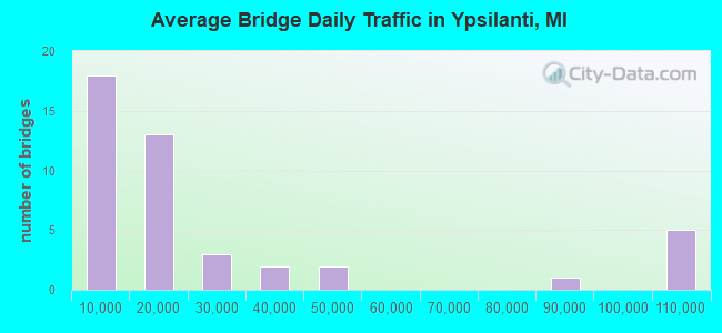
- 1,073,670Total average daily traffic
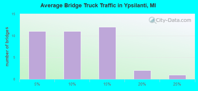
- 96,829Total average daily truck traffic
- National Bridge Inventory (NBI) Registered Bridges for Ypsilanti
- No street view available for this location
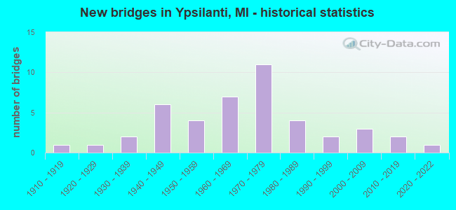
- New bridges - historical statistics
- 11910-1919
- 11920-1929
- 21930-1939
- 61940-1949
- 41950-1959
- 71960-1969
- 111970-1979
- 41980-1989
- 21990-1999
- 32000-2009
- 22010-2019
- 12020-2022
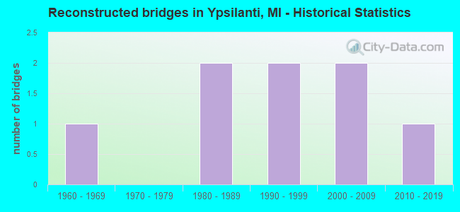
- Reconstructed bridges - Historical Statistics
- 11960-1969
- 01970-1979
- 21980-1989
- 21990-1999
- 22000-2009
- 12010-2019
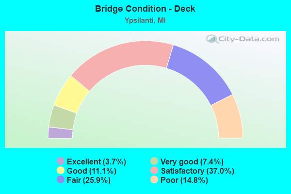
- Bridge Condition - Deck
- 3.7%Excellent
- 7.4%Very good
- 11.1%Good
- 37.0%Satisfactory
- 25.9%Fair
- 14.8%Poor
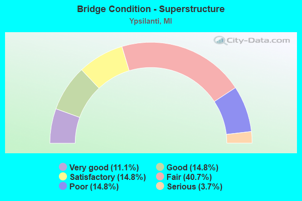
- Bridge Condition - Superstructure
- 11.1%Very good
- 14.8%Good
- 14.8%Satisfactory
- 40.7%Fair
- 14.8%Poor
- 3.7%Serious
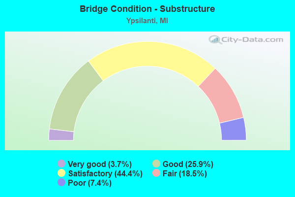
- Bridge Condition - Substructure
- 3.7%Very good
- 25.9%Good
- 44.4%Satisfactory
- 18.5%Fair
- 7.4%Poor
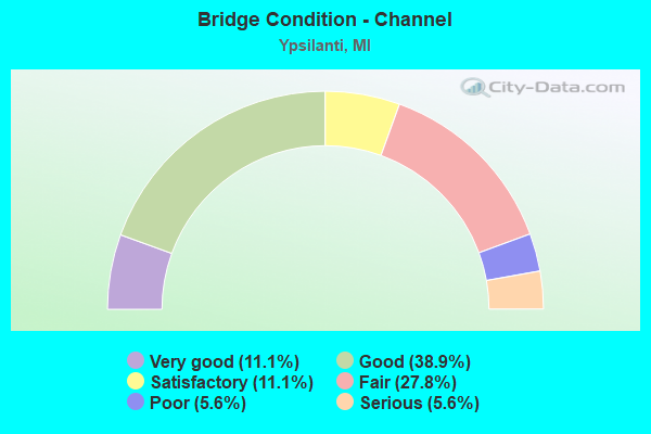
- Bridge Condition - Channel
- 11.1%Very good
- 38.9%Good
- 11.1%Satisfactory
- 27.8%Fair
- 5.6%Poor
- 5.6%Serious
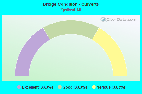
- Bridge Condition - Culverts
- 33.3%Excellent
- 33.3%Good
- 33.3%Serious
Find on map >> Show street view
Structure Number: 1109, Location: OVID TWP SEC 9-16 (Lat: 41.869303, Lng: -85.008897), Route carried "on" structure: County highway 1236, Year Built: 1961, Status: Posted for load, Structure Length: 0.67m (2.20ft), Average Daily Traffic: 532 (year 2004), Truck Traffic: 5%, Average Future Daily Traffic: 954 (year 2024), Design Load: H 20, Features Intersected: COLD WATER RIVER, Facility Carried by Structure: CENTRAL ROAD
Minimum Vertical Clearance: 30.48m (100.00ft), Kilometerpoint: 14.272, Lanes on structure: 2, Owner: County Highway Agency, Approaching Roadway Width: 14.3m (46.9ft), Material/Design: Wood or Timber, Design/Construction: Culvert, Number Of Spans In Main Unit: 4, Length of Maximum Span: 1.5m (4.9ft), Curb-To-Curb Width: 10.4m (34.1ft), Out-to-Out Width: 11.5m (37.7ft)
Condition: Channel: Serious, Culverts: Serious, Operating Rating: 16.0 metric tons, Method Used To Determine Operating Rating: Allowable Stress (AS), Inventory Rating: 10.0 metric tons, Method Used To Determine Inventory Rating: Allowable Stress (AS), Structural Evaluation: High priority of corrective action, Deck Geometry: Equal to present minimum criteria, Waterway Adequacy: High priority of corrective action, Approach Roadway Alignment: Equal to present desirable criteria, Bridge Posting: Required (Relationship of Operating Rating to Maximum Legal Load: 10.0 - 19.9% below), Length Of Structure Improvement: 0.67m (2.20ft), Designated Inspection Frequency: Every 12 months, Inspection Date: October 2021, Bridge Improvement Cost: $48,000, Total Project Cost: $55,000, Wearing Surface/Protective System: Wearing Surface: Bituminous
Find on map >> Show street view
Structure Number: 10815, Location: IN YPSILANTI (E MICH AVE) (Lat: 42.241044, Lng: -83.611600), Route carried "on" structure: Business US 12, Year Built: 1912, Status: Open, Structure Length: 3.20m (10.50ft), Average Daily Traffic: 21,936 (year 2007), Truck Traffic: 3%, Average Future Daily Traffic: 28,118 (year 2018), Design Load: H 15, Features Intersected: HURON RIVER
Minimum Vertical Clearance: 30.48m (100.00ft), Kilometerpoint: 3.051, Lanes on structure: 4, Base Highway Network: Yes (Inventory Route: 142, Subroute: 4), Owner: State Highway Agency, Approaching Roadway Width: 20.1m (65.9ft), Skew: 2 degrees, Material/Design: Concrete, Design/Construction: Arch - Deck, Number Of Spans In Main Unit: 1, Length of Maximum Span: 32.0m (105.0ft), Curb or Sidewalk Widths: Left: 1.9m (6.2ft), Right: 1.9m (6.2ft), Curb-To-Curb Width: 20.1m (65.9ft), Out-to-Out Width: 23.9m (78.4ft)
Condition: Deck: Poor, Superstructure: Fair, Substructure: Satisfactory, Channel: Satisfactory, Operating Rating: 40.5 metric tons, Method Used To Determine Operating Rating: Field evaluation and documented engineering judgment, Inventory Rating: 24.3 metric tons, Method Used To Determine Inventory Rating: Field evaluation and documented engineering judgment, Structural Evaluation: Somewhat better than minimum adequacy, Deck Geometry: Better than present minimum criteria, Waterway Adequacy: Better than present minimum criteria, Approach Roadway Alignment: Equal to present desirable criteria, Designated Inspection Frequency: Every 12 months, Underwater Inspection Frequency: Every 60 months, Inspection Date: August 2021, Underwater Inspection Date: August 2020, Deck Structure Type: Concrete Cast-file-Place, Wearing Surface/Protective System: Wearing Surface: Bituminous
Find on map >> Show street view
Structure Number: 10818, Location: IN YPSILANTI (E MICH AVE) (Lat: 42.241972, Lng: -83.598364), Route carried "on" structure: Business US 12, Year Built: 1934, Year Reconstructed: 2000, Status: Open, Structure Length: 5.91m (19.39ft), Average Daily Traffic: 14,908 (year 2007), Truck Traffic: 4%, Average Future Daily Traffic: 18,514 (year 2018), Design Load: HS 20, Features Intersected: MDOT RR CORRIDOR
Minimum Vertical Clearance: 30.48m (100.00ft), Kilometerpoint: 4.157, Lanes on structure: 4, Base Highway Network: Yes (Inventory Route: 142, Subroute: 4), Owner: State Highway Agency, Approaching Roadway Width: 15.8m (51.8ft), Skew: 6 degrees, Material/Design: Steel, Design/Construction: Girder and Floorbeam System, Number Of Spans In Main Unit: 3, Length of Maximum Span: 24.7m (81.0ft), Curb or Sidewalk Widths: Left: 1.5m (4.9ft), Right: 1.5m (4.9ft), Curb-To-Curb Width: 12.8m (42.0ft), Out-to-Out Width: 17.2m (56.4ft)
Condition: Deck: Fair, Superstructure: Fair, Substructure: Satisfactory, Operating Rating: 86.5 metric tons, Method Used To Determine Operating Rating: Load Factor (LF) rating reported by rating factor (RF) method using MS18 loading, Inventory Rating: 51.8 metric tons, Method Used To Determine Inventory Rating: Load Factor (LF) rating reported by rating factor (RF) method using MS18 loading, Structural Evaluation: Somewhat better than minimum adequacy, Deck Geometry: High priority of replacement, Underclear: Meets minimum limits, Approach Roadway Alignment: Equal to present minimum criteria, Designated Inspection Frequency: Every 24 months, Inspection Date: August 2020, Deck Structure Type: Concrete Cast-file-Place, Wearing Surface/Protective System: Wearing Surface: Epoxy Overlay
Find on map >> Show street view
Structure Number: 10819, Location: 1.2 MI E OF YPSILANTI (Lat: 42.246158, Lng: -83.580317), Route carried "on" structure: County highway 2006, Year Built: 1976, Status: Open, Structure Length: 4.89m (16.04ft), Average Daily Traffic: 15,000 (year 2007), Truck Traffic: 3%, Average Future Daily Traffic: 17,250 (year 2027), Design Load: HS 20, Features Intersected: US-12 BR, Facility Carried by Structure: FORD BLVD
Minimum Vertical Clearance: 30.48m (100.00ft), Kilometerpoint: 1.213, Lanes on structure: 3, Lanes under structure: 5, Owner: State Highway Agency, Approaching Roadway Width: 8.5m (27.9ft), Skew: 1 degrees, Material/Design: Steel, Design/Construction: Stringer/Multi-beam, Number Of Spans In Main Unit: 3, Length of Maximum Span: 26.4m (86.6ft), Curb or Sidewalk Widths: Left: 1.5m (4.9ft), Right: 1.5m (4.9ft), Curb-To-Curb Width: 14.6m (47.9ft), Out-to-Out Width: 18.4m (60.4ft)
Condition: Deck: Satisfactory, Superstructure: Satisfactory, Substructure: Good, Operating Rating: 73.5 metric tons, Method Used To Determine Operating Rating: Load Factor (LF) rating reported by rating factor (RF) method using MS18 loading, Inventory Rating: 44.1 metric tons, Method Used To Determine Inventory Rating: Load Factor (LF) rating reported by rating factor (RF) method using MS18 loading, Structural Evaluation: Equal to present minimum criteria, Deck Geometry: Somewhat better than minimum adequacy, Underclear: Somewhat better than minimum adequacy, Approach Roadway Alignment: Equal to present desirable criteria, Length Of Structure Improvement: 4.91m (16.11ft), Designated Inspection Frequency: Every 24 months, Inspection Date: August 2020, Bridge Improvement Cost: $215,000, Roadway Improvement Cost: $17,000, Total Project Cost: $201,000, Deck Structure Type: Concrete Cast-file-Place, Wearing Surface/Protective System: Wearing Surface: Epoxy Overlay, Deck Protection: Epoxy Coated Reinforcing
Find on map >> Show street view
Structure Number: 1082, Location: 1.0 MI E OF YPSILANTI (Lat: 42.231572, Lng: -83.578922), Route carried "on" structure: US 12, Year Built: 1988, Status: Open, Structure Length: 9.39m (30.81ft), Average Daily Traffic: 11,378 (year 2007), Truck Traffic: 5%, Average Future Daily Traffic: 12,733 (year 2018), Design Load: HS 25 or greater, Features Intersected: I-94 WB
Minimum Vertical Clearance: 30.48m (100.00ft), Kilometerpoint: 0.298, Lanes on structure: 2, Lanes under structure: 3, Base Highway Network: Yes (Inventory Route: 143, Subroute: 2), Owner: State Highway Agency, Approaching Roadway Width: 12.8m (42.0ft), Skew: 5 degrees, Material/Design: Steel continuous, Design/Construction: Stringer/Multi-beam, Number Of Spans In Main Unit: 3, Length of Maximum Span: 52.6m (172.6ft), Curb-To-Curb Width: 13.4m (44.0ft), Out-to-Out Width: 14.4m (47.2ft)
Condition: Deck: Satisfactory, Superstructure: Fair, Substructure: Satisfactory, Operating Rating: 70.3 metric tons, Method Used To Determine Operating Rating: Load Factor (LF) rating reported by rating factor (RF) method using MS18 loading, Inventory Rating: 42.1 metric tons, Method Used To Determine Inventory Rating: Load Factor (LF) rating reported by rating factor (RF) method using MS18 loading, Structural Evaluation: Somewhat better than minimum adequacy, Deck Geometry: Superior to present desirable criteria, Underclear: Better than present minimum criteria, Approach Roadway Alignment: Equal to present minimum criteria, Designated Inspection Frequency: Every 24 months, Other Special Inspection Frequency: Every 24 months, Inspection Date: August 2020, Other Special Inspection Date: August 2020, Deck Structure Type: Concrete Cast-file-Place, Wearing Surface/Protective System: Wearing Surface: Epoxy Overlay, Deck Protection: Epoxy Coated Reinforcing
Find on map >> Show street view
Structure Number: 10821, Location: 2.0 MI SE OF YPSILANTI (Lat: 42.219894, Lng: -83.562247), Route carried "on" structure: Interstate 94, Year Built: 1958, Year Reconstructed: 1986, Status: Open, Structure Length: 8.20m (26.90ft), Average Daily Traffic: 42,518 (year 2007), Truck Traffic: 14%, Average Future Daily Traffic: 45,981 (year 2018), Design Load: HS 20+Mod, Features Intersected: WIARD RD
Minimum Vertical Clearance: 30.48m (100.00ft), Kilometerpoint: 51.996, Lanes on structure: 3, Lanes under structure: 4, Base Highway Network: Yes (Inventory Route: 142, Subroute: 9), Owner: State Highway Agency, Approaching Roadway Width: 18.2m (59.7ft), Skew: 35 degrees, Material/Design: Steel continuous, Design/Construction: Stringer/Multi-beam, Number Of Spans In Main Unit: 4, Length of Maximum Span: 24.3m (79.7ft), Curb-To-Curb Width: 18.3m (60.0ft), Out-to-Out Width: 19.3m (63.3ft)
Condition: Deck: Satisfactory, Superstructure: Fair, Substructure: Satisfactory, Operating Rating: 60.2 metric tons, Method Used To Determine Operating Rating: Load Factor (LF), Inventory Rating: 36.1 metric tons, Method Used To Determine Inventory Rating: Load Factor (LF), Structural Evaluation: Somewhat better than minimum adequacy, Deck Geometry: Better than present minimum criteria, Underclear: High priority of corrective action, Approach Roadway Alignment: Better than present minimum criteria, Designated Inspection Frequency: Every 24 months, Inspection Date: August 2020, Deck Structure Type: Concrete Cast-file-Place, Wearing Surface/Protective System: Wearing Surface: Latex Concrete, Deck Protection: Epoxy Coated Reinforcing
Find on map >> Show street view
Structure Number: 10822, Location: 2.0 MI SE OF YPSILANTI (Lat: 42.220150, Lng: -83.562292), Route carried "on" structure: Interstate 94, Year Built: 1958, Year Reconstructed: 1986, Status: Open, Structure Length: 7.65m (25.10ft), Average Daily Traffic: 42,518 (year 2007), Truck Traffic: 14%, Average Future Daily Traffic: 45,981 (year 2018), Design Load: HS 20+Mod, Features Intersected: WIARD RD
Minimum Vertical Clearance: 30.48m (100.00ft), Kilometerpoint: 51.940, Lanes on structure: 3, Lanes under structure: 4, Base Highway Network: Yes (Inventory Route: 142, Subroute: 10), Owner: State Highway Agency, Approaching Roadway Width: 18.2m (59.7ft), Skew: 34 degrees, Material/Design: Steel continuous, Design/Construction: Stringer/Multi-beam, Number Of Spans In Main Unit: 4, Length of Maximum Span: 23.7m (77.8ft), Curb-To-Curb Width: 18.3m (60.0ft), Out-to-Out Width: 19.3m (63.3ft)
Condition: Deck: Satisfactory, Superstructure: Good, Substructure: Satisfactory, Operating Rating: 65.5 metric tons, Method Used To Determine Operating Rating: Load Factor (LF), Inventory Rating: 39.3 metric tons, Method Used To Determine Inventory Rating: Load Factor (LF), Structural Evaluation: Equal to present minimum criteria, Deck Geometry: Better than present minimum criteria, Underclear: High priority of corrective action, Approach Roadway Alignment: Better than present minimum criteria, Length Of Structure Improvement: 7.65m (25.10ft), Designated Inspection Frequency: Every 24 months, Inspection Date: August 2020, Bridge Improvement Cost: $105,000, Roadway Improvement Cost: $11,000, Total Project Cost: $124,000, Deck Structure Type: Concrete Cast-file-Place, Wearing Surface/Protective System: Wearing Surface: Latex Concrete, Deck Protection: Epoxy Coated Reinforcing
Find on map >> Show street view
Structure Number: 10841, Location: 2.0 MI W OF YPSILANTI (Lat: 42.224364, Lng: -83.651181), Route carried "on" structure: US 12, Year Built: 1975, Status: Open, Structure Length: 12.98m (42.59ft), Average Daily Traffic: 20,815 (year 2007), Truck Traffic: 6%, Average Future Daily Traffic: 30,194 (year 2018), Design Load: HS 25 or greater, Features Intersected: I-94
Minimum Vertical Clearance: 30.48m (100.00ft), Kilometerpoint: 0.737, Lanes on structure: 6, Lanes under structure: 7, Base Highway Network: Yes (Inventory Route: 142, Subroute: 7), Owner: State Highway Agency, Approaching Roadway Width: 29.2m (95.8ft), Skew: 5 degrees, Material/Design: Steel, Design/Construction: Stringer/Multi-beam, Number Of Spans In Main Unit: 4, Length of Maximum Span: 48.4m (158.8ft), Curb-To-Curb Width: 28.0m (91.9ft), Out-to-Out Width: 28.6m (93.8ft)
Condition: Deck: Satisfactory, Superstructure: Fair, Substructure: Fair, Operating Rating: 61.9 metric tons, Method Used To Determine Operating Rating: Load Factor (LF) rating reported by rating factor (RF) method using MS18 loading, Inventory Rating: 36.9 metric tons, Method Used To Determine Inventory Rating: Load Factor (LF) rating reported by rating factor (RF) method using MS18 loading, Structural Evaluation: Somewhat better than minimum adequacy, Deck Geometry: Superior to present desirable criteria, Underclear: Somewhat better than minimum adequacy, Approach Roadway Alignment: Equal to present desirable criteria, Designated Inspection Frequency: Every 24 months, Other Special Inspection Frequency: Every 24 months, Inspection Date: June 2021, Other Special Inspection Date: June 2020, Deck Structure Type: Concrete Cast-file-Place, Wearing Surface/Protective System: Wearing Surface: Latex Concrete
Find on map >> Show street view
Structure Number: 10843, Location: IN YPSILANTI (Lat: 42.230925, Lng: -83.606953), Route carried "on" structure: Interstate 94, Year Built: 1971, Status: Open, Structure Length: 3.35m (10.99ft), Average Daily Traffic: 102,776 (year 2007), Truck Traffic: 10%, Average Future Daily Traffic: 117,095 (year 2018), Design Load: HS 20+Mod, Features Intersected: HURON RIVER
Minimum Vertical Clearance: 30.48m (100.00ft), Kilometerpoint: 47.844, Lanes on structure: 6, Base Highway Network: Yes (Inventory Route: 142, Subroute: 9), Owner: State Highway Agency, Approaching Roadway Width: 35.4m (116.1ft), Skew: 30 degrees, Material/Design: Prestressed concrete, Design/Construction: Box Beam or Girders - Multiple, Number Of Spans In Main Unit: 3, Length of Maximum Span: 12.8m (42.0ft), Curb-To-Curb Width: 33.2m (108.9ft), Out-to-Out Width: 33.9m (111.2ft)
Condition: Deck: Satisfactory, Superstructure: Fair, Substructure: Fair, Channel: Fair, Operating Rating: 68.7 metric tons, Method Used To Determine Operating Rating: Load Factor (LF) rating reported by rating factor (RF) method using MS18 loading, Inventory Rating: 41.1 metric tons, Method Used To Determine Inventory Rating: Load Factor (LF) rating reported by rating factor (RF) method using MS18 loading, Structural Evaluation: Somewhat better than minimum adequacy, Deck Geometry: Superior to present desirable criteria, Waterway Adequacy: Equal to present desirable criteria, Approach Roadway Alignment: Better than present minimum criteria, Designated Inspection Frequency: Every 24 months, Underwater Inspection Frequency: Every 60 months, Inspection Date: August 2020, Underwater Inspection Date: August 2020, Deck Structure Type: Concrete Cast-file-Place, Wearing Surface/Protective System: Wearing Surface: Latex Concrete
Find on map >> Show street view
Structure Number: 10847, Location: S LTS OF YPSILANTI (Lat: 42.228925, Lng: -83.616886), Route carried "on" structure: Business US 12, Year Built: 1969, Year Reconstructed: 1998, Status: Temporarily open, Structure Length: 7.74m (25.39ft), Average Daily Traffic: 31,936 (year 2007), Truck Traffic: 3%, Average Future Daily Traffic: 31,554 (year 2018), Design Load: HS 20, Features Intersected: I-94
Minimum Vertical Clearance: 30.48m (100.00ft), Kilometerpoint: 0.346, Lanes on structure: 5, Lanes under structure: 8, Base Highway Network: Yes (Inventory Route: 460, Subroute: 70), Owner: State Highway Agency, Approaching Roadway Width: 28.9m (94.8ft), Skew: 23 degrees, Material/Design: Steel, Design/Construction: Stringer/Multi-beam, Number Of Spans In Main Unit: 4, Length of Maximum Span: 25.9m (85.0ft), Curb-To-Curb Width: 21.8m (71.5ft), Out-to-Out Width: 25.3m (83.0ft)
Condition: Deck: Satisfactory, Superstructure: Fair, Substructure: Satisfactory, Operating Rating: 85.6 metric tons, Method Used To Determine Operating Rating: Load Factor (LF), Inventory Rating: 51.3 metric tons, Method Used To Determine Inventory Rating: Load Factor (LF), Structural Evaluation: Somewhat better than minimum adequacy, Deck Geometry: Somewhat better than minimum adequacy, Underclear: Somewhat better than minimum adequacy, Approach Roadway Alignment: Equal to present desirable criteria, Designated Inspection Frequency: Every 24 months, Inspection Date: August 2020, Deck Structure Type: Concrete Cast-file-Place, Wearing Surface/Protective System: Wearing Surface: Latex Concrete
Find on map >> Show street view
Structure Number: 10848, Location: IN YPSILANTI (Lat: 42.231453, Lng: -83.599881), Route carried "on" structure: City street 2006, Year Built: 1972, Year Reconstructed: 2005, Status: Open, Structure Length: 10.81m (35.47ft), Average Daily Traffic: 6,486 (year 2010), Average Future Daily Traffic: 7,135 (year 2025), Design Load: H 20, Features Intersected: I-94, Facility Carried by Structure: GROVE ST
Minimum Vertical Clearance: 30.48m (100.00ft), Kilometerpoint: 1.728, Lanes on structure: 3, Lanes under structure: 6, Owner: State Highway Agency, Approaching Roadway Width: 13.4m (44.0ft), Skew: 4 degrees, Material/Design: Steel, Design/Construction: Stringer/Multi-beam, Number Of Spans In Main Unit: 4, Length of Maximum Span: 36.2m (118.8ft), Curb or Sidewalk Widths: Left: 1.8m (5.9ft), Right: 1.8m (5.9ft), Curb-To-Curb Width: 15.8m (51.8ft), Out-to-Out Width: 20.2m (66.3ft)
Condition: Deck: Satisfactory, Superstructure: Satisfactory, Substructure: Fair, Operating Rating: 69.7 metric tons, Method Used To Determine Operating Rating: Load Factor (LF) rating reported by rating factor (RF) method using MS18 loading, Inventory Rating: 41.8 metric tons, Method Used To Determine Inventory Rating: Load Factor (LF) rating reported by rating factor (RF) method using MS18 loading, Structural Evaluation: Somewhat better than minimum adequacy, Deck Geometry: Better than present minimum criteria, Underclear: Somewhat better than minimum adequacy, Approach Roadway Alignment: Somewhat better than minimum adequacy, Designated Inspection Frequency: Every 24 months, Inspection Date: August 2020, Deck Structure Type: Concrete Cast-file-Place, Wearing Surface/Protective System: Wearing Surface: Monolithic Concrete, Deck Protection: Epoxy Coated Reinforcing
Find on map >> Show street view
Structure Number: 10851, Location: 1.4 MI W OF CO LINE/WIARD (Lat: 42.242506, Lng: -83.565947), Route carried "on" structure: US 12, Year Built: 1942, Year Reconstructed: 2017, Status: Open, Structure Length: 4.34m (14.24ft), Average Daily Traffic: 38,000 (year 1995), Truck Traffic: 3%, Average Future Daily Traffic: 34,779 (year 2015), Design Load: HS 20, Features Intersected: ACM TEST TRACK
Minimum Vertical Clearance: 4.27m (14.01ft), Kilometerpoint: 0.361, Lanes on structure: 5, Lanes under structure: 2, Base Highway Network: Yes (Inventory Route: 143, Subroute: 6), Owner: State Highway Agency, Approaching Roadway Width: 20.9m (68.6ft), Skew: 3 degrees, Material/Design: Steel, Design/Construction: Stringer/Multi-beam, Number Of Spans In Main Unit: 3, Length of Maximum Span: 15.8m (51.8ft), Curb-To-Curb Width: 21.5m (70.5ft), Out-to-Out Width: 22.2m (72.8ft)
Condition: Deck: Excellent, Superstructure: Satisfactory, Substructure: Satisfactory, Operating Rating: 73.5 metric tons, Method Used To Determine Operating Rating: Load Factor (LF) rating reported by rating factor (RF) method using MS18 loading, Inventory Rating: 44.1 metric tons, Method Used To Determine Inventory Rating: Load Factor (LF) rating reported by rating factor (RF) method using MS18 loading, Structural Evaluation: Equal to present minimum criteria, Deck Geometry: High priority of corrective action, Underclear: High priority of corrective action, Approach Roadway Alignment: Equal to present desirable criteria, Length Of Structure Improvement: 4.33m (14.21ft), Designated Inspection Frequency: Every 24 months, Inspection Date: August 2020, Bridge Improvement Cost: $305,000, Roadway Improvement Cost: $4,000, Total Project Cost: $45,000, Deck Structure Type: Concrete Cast-file-Place, Wearing Surface/Protective System: Wearing Surface: Monolithic Concrete, Deck Protection: Epoxy Coated Reinforcing
Find on map >> Show street view
Structure Number: 1097, Location: YPSILANTI TWP SEC 21 (Lat: 42.201769, Lng: -83.612467), Route carried "on" structure: County highway 2006, Year Built: 1930, Status: Open, Structure Length: 0.79m (2.59ft), Average Daily Traffic: 7,252 (year 2006), Truck Traffic: 7%, Average Future Daily Traffic: 13,097 (year 2026), Design Load: HS 20+Mod, Features Intersected: PAINT CREEK, Facility Carried by Structure: TEXTILE ROAD
Minimum Vertical Clearance: 30.48m (100.00ft), Kilometerpoint: 5.916, Lanes on structure: 2, Owner: County Highway Agency, Approaching Roadway Width: 11.9m (39.0ft), Skew: 2 degrees, Material/Design: Concrete, Design/Construction: Slab, Number Of Spans In Main Unit: 1, Length of Maximum Span: 6.7m (22.0ft), Curb-To-Curb Width: 11.9m (39.0ft), Out-to-Out Width: 12.8m (42.0ft)
Condition: Deck: Fair, Superstructure: Fair, Substructure: Satisfactory, Channel: Fair, Operating Rating: 46.7 metric tons, Method Used To Determine Operating Rating: Allowable Stress (AS), Inventory Rating: 26.0 metric tons, Method Used To Determine Inventory Rating: Allowable Stress (AS), Structural Evaluation: Somewhat better than minimum adequacy, Deck Geometry: Somewhat better than minimum adequacy, Waterway Adequacy: Equal to present desirable criteria, Approach Roadway Alignment: Better than present minimum criteria, Length Of Structure Improvement: 1.22m (4.00ft), Designated Inspection Frequency: Every 24 months, Inspection Date: June 2021, Bridge Improvement Cost: $120,000, Roadway Improvement Cost: $20,000, Total Project Cost: $190,000, Deck Structure Type: Concrete Cast-file-Place, Wearing Surface/Protective System: Wearing Surface: Bituminous
Find on map >> Show street view
Structure Number: 10971, Location: YPSILANTI TWP SEC 24 (Lat: 42.205806, Lng: -83.557664), Route carried "on" structure: County highway 2006, Year Built: 1992, Status: Open, Structure Length: 6.61m (21.69ft), Average Daily Traffic: 7,289 (year 2020), Truck Traffic: 15%, Average Future Daily Traffic: 10,831 (year 2040), Design Load: HS 20, Features Intersected: HURON RIVER, Facility Carried by Structure: BRIDGE ROAD
Minimum Vertical Clearance: 30.48m (100.00ft), Kilometerpoint: 0.377, Lanes on structure: 4, Owner: County Highway Agency, Approaching Roadway Width: 14.9m (48.9ft), Material/Design: Prestressed concrete, Design/Construction: Stringer/Multi-beam, Number Of Spans In Main Unit: 7, Length of Maximum Span: 11.8m (38.7ft), Curb or Sidewalk Widths: Left: 0.0m, Right: 2.4m (7.9ft), Curb-To-Curb Width: 14.8m (48.6ft), Out-to-Out Width: 17.9m (58.7ft)
Condition: Deck: Good, Superstructure: Good, Substructure: Good, Channel: Very good, Operating Rating: 45.5 metric tons, Method Used To Determine Operating Rating: Load Factor (LF), Inventory Rating: 27.3 metric tons, Method Used To Determine Inventory Rating: Load Factor (LF), Structural Evaluation: Equal to present minimum criteria, Deck Geometry: High priority of replacement, Waterway Adequacy: Better than present minimum criteria, Approach Roadway Alignment: Better than present minimum criteria, Designated Inspection Frequency: Every 24 months, Inspection Date: April 2020, Deck Structure Type: Concrete Cast-file-Place, Wearing Surface/Protective System: Wearing Surface: Epoxy Overlay, Deck Protection: Epoxy Coated Reinforcing
Find on map >> Show street view
Structure Number: 10972, Location: YPSILANTI TWP SEC 12 (Lat: 42.232656, Lng: -83.547422), Route carried "on" structure: County highway , Year Built: 1942, Status: Open, Structure Length: 1.15m (3.77ft), Average Daily Traffic: 1,643 (year 2006), Truck Traffic: 18%, Average Future Daily Traffic: 2,967 (year 2026), Design Load: HS 20+Mod, Features Intersected: WILLOW RUN, Facility Carried by Structure: TYLER ROAD
Minimum Vertical Clearance: 30.48m (100.00ft), Kilometerpoint: 1.527, Lanes on structure: 2, Owner: County Highway Agency, Approaching Roadway Width: 18.0m (59.1ft), Material/Design: Concrete continuous, Design/Construction: Slab, Number Of Spans In Main Unit: 4, Length of Maximum Span: 2.7m (8.9ft), Curb or Sidewalk Widths: Left: 1.4m (4.6ft), Right: 1.4m (4.6ft), Curb-To-Curb Width: 7.3m (24.0ft), Out-to-Out Width: 16.8m (55.1ft)
Condition: Deck: Fair, Superstructure: Fair, Substructure: Satisfactory, Channel: Good, Operating Rating: 60.9 metric tons, Method Used To Determine Operating Rating: Allowable Stress (AS), Inventory Rating: 42.7 metric tons, Method Used To Determine Inventory Rating: Allowable Stress (AS), Structural Evaluation: Somewhat better than minimum adequacy, Deck Geometry: Meets minimum limits, Waterway Adequacy: Better than present minimum criteria, Approach Roadway Alignment: Equal to present desirable criteria, Designated Inspection Frequency: Every 24 months, Inspection Date: June 2021, Deck Structure Type: Concrete Cast-file-Place, Wearing Surface/Protective System: Wearing Surface: Bituminous
Find on map >> Show street view
Structure Number: 10977, Location: SUPERIOR TWP SECTION 25 (Lat: 42.276614, Lng: -83.559525), Route carried "on" structure: County highway 8154, Year Built: 2021, Status: Open, Structure Length: 0.73m (2.40ft), Average Daily Traffic: 9,991 (year 2020), Truck Traffic: 14%, Average Future Daily Traffic: 16,019 (year 2040), Design Load: Greater than HL93, Features Intersected: FOWLER CREEK, Facility Carried by Structure: GEDDES ROAD
Minimum Vertical Clearance: 30.48m (100.00ft), Kilometerpoint: 15.178, Lanes on structure: 2, Owner: County Highway Agency, Approaching Roadway Width: 12.2m (40.0ft), Skew: 1 degrees, Material/Design: Concrete, Design/Construction: Culvert, Number Of Spans In Main Unit: 1, Length of Maximum Span: 7.3m (24.0ft), Curb or Sidewalk Widths: Left: 0.6m (2.0ft), Right: 0.6m (2.0ft), Curb-To-Curb Width: 12.2m (40.0ft), Out-to-Out Width: 15.8m (51.8ft)
Condition: Channel: Very good, Culverts: Excellent, Operating Rating: 66.4 metric tons, Method Used To Determine Operating Rating: Load and Resistance Factor Rating (LRFR) rating reported by rating factor(RF) method using HL-93 loadings, Inventory Rating: 51.2 metric tons, Method Used To Determine Inventory Rating: Load and Resistance Factor Rating (LRFR) rating reported by rating factor(RF) method using HL-93 loadings, Structural Evaluation: Superior to present desirable criteria, Deck Geometry: Somewhat better than minimum adequacy, Waterway Adequacy: Equal to present desirable criteria, Approach Roadway Alignment: Better than present minimum criteria, Length Of Structure Improvement: 1.46m (4.79ft), Designated Inspection Frequency: Every 17 months, Inspection Date: January 2022, Bridge Improvement Cost: $80,000, Roadway Improvement Cost: $20,000, Total Project Cost: $130,000, Wearing Surface/Protective System: Wearing Surface: Bituminous
Find on map >> Show street view
Structure Number: 11002, Location: YPSILANTI TWP SEC 20 & 21 (Lat: 42.206014, Lng: -83.621025), Route carried "on" structure: County highway 2006, Year Built: 1920, Year Reconstructed: 1966, Status: Posted for load, Structure Length: 0.85m (2.79ft), Average Daily Traffic: 8,856 (year 2006), Truck Traffic: 10%, Average Future Daily Traffic: 15,994 (year 2026), Design Load: HS 20+Mod, Features Intersected: PAINT CREEK, Facility Carried by Structure: STONY CREEK ROAD
Minimum Vertical Clearance: 30.48m (100.00ft), Kilometerpoint: 17.834, Lanes on structure: 2, Owner: County Highway Agency, Approaching Roadway Width: 9.1m (29.9ft), Material/Design: Concrete, Design/Construction: Tee Beam, Number Of Spans In Main Unit: 1, Length of Maximum Span: 8.2m (26.9ft), Curb-To-Curb Width: 9.1m (29.9ft), Out-to-Out Width: 9.2m (30.2ft)
Condition: Deck: Satisfactory, Superstructure: Poor, Substructure: Fair, Channel: Poor, Operating Rating: 34.7 metric tons, Method Used To Determine Operating Rating: Load Factor (LF) rating reported by rating factor (RF) method using MS18 loading, Inventory Rating: 20.7 metric tons, Method Used To Determine Inventory Rating: Load Factor (LF) rating reported by rating factor (RF) method using MS18 loading, Structural Evaluation: Meets minimum limits, Deck Geometry: High priority of corrective action, Waterway Adequacy: Equal to present desirable criteria, Approach Roadway Alignment: Better than present minimum criteria, Bridge Posting: Required (Relationship of Operating Rating to Maximum Legal Load: > 39.9% below), Length Of Structure Improvement: 1.46m (4.79ft), Designated Inspection Frequency: Every 12 months, Inspection Date: June 2021, Bridge Improvement Cost: $95,000, Roadway Improvement Cost: $15,000, Total Project Cost: $130,000, Deck Structure Type: Concrete Cast-file-Place, Wearing Surface/Protective System: Wearing Surface: Bituminous
Find on map >> Show street view
Structure Number: 11005, Location: YPSILANTI TWP SEC 28 (Lat: 42.190281, Lng: -83.610667), Route carried "on" structure: County highway 8189, Year Built: 2007, Status: Open, Structure Length: 1.25m (4.10ft), Average Daily Traffic: 11,389 (year 2006), Truck Traffic: 12%, Average Future Daily Traffic: 20,569 (year 2026), Design Load: HS 20+Mod, Features Intersected: PAINT CREEK, Facility Carried by Structure: WHITTAKER ROAD
Minimum Vertical Clearance: 30.48m (100.00ft), Kilometerpoint: 12.072, Lanes on structure: 2, Owner: County Highway Agency, Approaching Roadway Width: 9.1m (29.9ft), Material/Design: Prestressed concrete, Design/Construction: Box Beam or Girders - Multiple, Number Of Spans In Main Unit: 1, Length of Maximum Span: 12.5m (41.0ft), Curb-To-Curb Width: 12.2m (40.0ft), Out-to-Out Width: 18.3m (60.0ft)
Condition: Deck: Good, Superstructure: Very good, Substructure: Good, Channel: Good, Operating Rating: 71.2 metric tons, Method Used To Determine Operating Rating: Load Factor (LF), Inventory Rating: 42.7 metric tons, Method Used To Determine Inventory Rating: Load Factor (LF), Structural Evaluation: Better than present minimum criteria, Deck Geometry: Somewhat better than minimum adequacy, Waterway Adequacy: Better than present minimum criteria, Approach Roadway Alignment: Equal to present minimum criteria, Designated Inspection Frequency: Every 24 months, Inspection Date: April 2020, Deck Structure Type: Concrete Cast-file-Place, Wearing Surface/Protective System: Wearing Surface: Integral Concrete, Deck Protection: Epoxy Coated Reinforcing
Find on map >> Show street view
Structure Number: 11006, Location: YPSILANTI TWP SECTION 5 (Lat: 42.260467, Lng: -83.638575), Route carried "on" structure: County highway 2006, Year Built: 1973, Status: Open, Structure Length: 5.34m (17.52ft), Average Daily Traffic: 4,169 (year 2016), Truck Traffic: 1%, Average Future Daily Traffic: 4,321 (year 2036), Design Load: HS 20+Mod, Features Intersected: HURON RIVER, Facility Carried by Structure: SUPERIOR ROAD
Minimum Vertical Clearance: 30.48m (100.00ft), Kilometerpoint: 1.605, Lanes on structure: 4, Owner: County Highway Agency, Approaching Roadway Width: 15.8m (51.8ft), Skew: 1 degrees, Material/Design: Steel, Design/Construction: Stringer/Multi-beam, Number Of Spans In Main Unit: 3, Length of Maximum Span: 17.6m (57.7ft), Curb or Sidewalk Widths: Left: 1.5m (4.9ft), Right: 1.5m (4.9ft), Curb-To-Curb Width: 15.5m (50.9ft), Out-to-Out Width: 19.4m (63.6ft)
Condition: Deck: Good, Superstructure: Good, Substructure: Satisfactory, Channel: Good, Operating Rating: 79.1 metric tons, Method Used To Determine Operating Rating: Load Factor (LF), Inventory Rating: 47.4 metric tons, Method Used To Determine Inventory Rating: Load Factor (LF), Structural Evaluation: Equal to present minimum criteria, Deck Geometry: Meets minimum limits, Waterway Adequacy: Superior to present desirable criteria, Approach Roadway Alignment: Equal to present desirable criteria, Length Of Structure Improvement: 6.71m (22.01ft), Designated Inspection Frequency: Every 24 months, Underwater Inspection Frequency: Every 60 months, Inspection Date: September 2021, Underwater Inspection Date: October 2018, Bridge Improvement Cost: $1,240,000, Roadway Improvement Cost: $124,000, Total Project Cost: $1,500,000, Deck Structure Type: Concrete Cast-file-Place, Wearing Surface/Protective System: Wearing Surface: Epoxy Overlay
Find on map >> Show street view
Structure Number: 11007, Location: YPSILANTI TWP SEC 11 (Lat: 42.245172, Lng: -83.580286), Route carried "on" structure: County highway 2006, Year Built: 2013, Status: Open, Structure Length: 3.14m (10.30ft), Average Daily Traffic: 16,513 (year 2006), Truck Traffic: 20%, Average Future Daily Traffic: 16,600 (year 2031), Design Load: HS 20+Mod, Features Intersected: MDOT RR CORRIDOR, Facility Carried by Structure: FORD BOULEVARD
Minimum Vertical Clearance: 30.48m (100.00ft), Kilometerpoint: 1.104, Lanes on structure: 4, Owner: County Highway Agency, Approaching Roadway Width: 14.6m (47.9ft), Skew: 1 degrees, Material/Design: Prestressed concrete, Design/Construction: Box Beam or Girders - Single/Spread, Number Of Spans In Main Unit: 1, Length of Maximum Span: 30.5m (100.1ft), Curb or Sidewalk Widths: Left: 1.8m (5.9ft), Right: 1.8m (5.9ft), Curb-To-Curb Width: 18.3m (60.0ft), Out-to-Out Width: 22.6m (74.1ft)
Condition: Deck: Very good, Superstructure: Very good, Substructure: Very good, Operating Rating: 57.0 metric tons, Method Used To Determine Operating Rating: Load and Resistance Factor Rating (LRFR) rating reported by rating factor(RF) method using HL-93 loadings, Inventory Rating: 39.9 metric tons, Method Used To Determine Inventory Rating: Load and Resistance Factor Rating (LRFR) rating reported by rating factor(RF) method using HL-93 loadings, Structural Evaluation: Equal to present desirable criteria, Deck Geometry: Somewhat better than minimum adequacy, Underclear: Meets minimum limits, Approach Roadway Alignment: Equal to present desirable criteria, Designated Inspection Frequency: Every 24 months, Inspection Date: May 2021, Deck Structure Type: Concrete Cast-file-Place, Wearing Surface/Protective System: Wearing Surface: Monolithic Concrete, Deck Protection: Epoxy Coated Reinforcing
Find on map >> Show street view
Structure Number: 11033, Location: YPSILANTI TWP SEC 34 (Lat: 42.173467, Lng: -83.587561), Route carried "on" structure: County highway , Year Built: 1964, Status: Open, Structure Length: 0.97m (3.18ft), Average Daily Traffic: 449 (year 2005), Truck Traffic: 5%, Average Future Daily Traffic: 811 (year 2025), Design Load: HS 20+Mod, Features Intersected: PAINT CREEK, Facility Carried by Structure: BEMIS
Minimum Vertical Clearance: 30.48m (100.00ft), Kilometerpoint: 15.238, Lanes on structure: 2, Owner: County Highway Agency, Approaching Roadway Width: 10.1m (33.1ft), Material/Design: Prestressed concrete, Design/Construction: Box Beam or Girders - Multiple, Number Of Spans In Main Unit: 1, Length of Maximum Span: 9.4m (30.8ft), Curb-To-Curb Width: 7.0m (23.0ft), Out-to-Out Width: 7.3m (24.0ft)
Condition: Deck: Poor, Superstructure: Poor, Substructure: Good, Channel: Fair, Operating Rating: 46.9 metric tons, Method Used To Determine Operating Rating: Load Factor (LF), Inventory Rating: 28.1 metric tons, Method Used To Determine Inventory Rating: Load Factor (LF), Structural Evaluation: Meets minimum limits, Deck Geometry: Meets minimum limits, Waterway Adequacy: Equal to present minimum criteria, Approach Roadway Alignment: Equal to present desirable criteria, Length Of Structure Improvement: 1.65m (5.41ft), Designated Inspection Frequency: Every 24 months, Inspection Date: June 2021, Bridge Improvement Cost: $85,000, Roadway Improvement Cost: $12,000, Total Project Cost: $100,000, Deck Structure Type: Concrete Precast Panels, Wearing Surface/Protective System: Wearing Surface: Bituminous, Membrane: Preformed Fabric
Find on map >> Show street view
Structure Number: 11034, Location: YPSILANTI TWP SEC 34 (Lat: 42.180631, Lng: -83.594694), Route carried "on" structure: County highway , Year Built: 1965, Status: Open, Structure Length: 0.97m (3.18ft), Average Daily Traffic: 4,021 (year 2015), Truck Traffic: 9%, Average Future Daily Traffic: 6,720 (year 2035), Design Load: HS 20+Mod, Features Intersected: PAINT CREEK, Facility Carried by Structure: MARTZ RD
Minimum Vertical Clearance: 30.48m (100.00ft), Kilometerpoint: 0.658, Lanes on structure: 2, Owner: County Highway Agency, Approaching Roadway Width: 10.1m (33.1ft), Material/Design: Prestressed concrete, Design/Construction: Box Beam or Girders - Multiple, Number Of Spans In Main Unit: 1, Length of Maximum Span: 9.7m (31.8ft), Curb-To-Curb Width: 7.9m (25.9ft), Out-to-Out Width: 8.3m (27.2ft)
Condition: Deck: Fair, Superstructure: Fair, Substructure: Good, Channel: Fair, Operating Rating: 42.9 metric tons, Method Used To Determine Operating Rating: Load Factor (LF), Inventory Rating: 25.7 metric tons, Method Used To Determine Inventory Rating: Load Factor (LF), Structural Evaluation: Somewhat better than minimum adequacy, Deck Geometry: High priority of corrective action, Waterway Adequacy: Equal to present desirable criteria, Approach Roadway Alignment: Equal to present desirable criteria, Length Of Structure Improvement: 1.65m (5.41ft), Designated Inspection Frequency: Every 24 months, Inspection Date: April 2020, Bridge Improvement Cost: $85,000, Roadway Improvement Cost: $12,000, Total Project Cost: $100,000, Deck Structure Type: Concrete Precast Panels, Wearing Surface/Protective System: Wearing Surface: Bituminous, Membrane: Preformed Fabric
Find on map >> Show street view
Structure Number: 11035, Location: YPSILANTI TWP SEC 28 & 33 (Lat: 42.188300, Lng: -83.606708), Route carried "on" structure: County highway , Year Built: 1965, Status: Open, Structure Length: 0.97m (3.18ft), Average Daily Traffic: 230 (year 2012), Truck Traffic: 5%, Average Future Daily Traffic: 224 (year 2026), Design Load: HS 20+Mod, Features Intersected: PAINT CREEK, Facility Carried by Structure: MERRITT RD
Minimum Vertical Clearance: 30+ m (98+ ft), Kilometerpoint: 6.365, Lanes on structure: 2, Owner: County Highway Agency, Approaching Roadway Width: 10.1m (33.1ft), Material/Design: Prestressed concrete, Design/Construction: Box Beam or Girders - Multiple, Number Of Spans In Main Unit: 1, Length of Maximum Span: 9.7m (31.8ft), Curb-To-Curb Width: 7.9m (25.9ft), Out-to-Out Width: 8.3m (27.2ft)
Condition: Deck: Poor, Superstructure: Poor, Substructure: Good, Channel: Good, Operating Rating: 51.8 metric tons, Method Used To Determine Operating Rating: Load Factor (LF), Inventory Rating: 31.2 metric tons, Method Used To Determine Inventory Rating: Load Factor (LF), Structural Evaluation: Meets minimum limits, Deck Geometry: Somewhat better than minimum adequacy, Waterway Adequacy: Equal to present desirable criteria, Approach Roadway Alignment: Equal to present desirable criteria, Length Of Structure Improvement: 1.74m (5.71ft), Designated Inspection Frequency: Every 24 months, Inspection Date: April 2021, Bridge Improvement Cost: $95,000, Roadway Improvement Cost: $15,000, Total Project Cost: $130,000, Deck Structure Type: Concrete Precast Panels, Wearing Surface/Protective System: Wearing Surface: Bituminous, Membrane: Preformed Fabric
Find on map >> Show street view
Structure Number: 11088, Location: IN THE CITY OF YPSILANTI (Lat: 42.234711, Lng: -83.606822), Route carried "on" structure: City street 2006, Year Built: 1978, Status: Open, Structure Length: 6.89m (22.60ft), Average Daily Traffic: 11,700 (year 2019), Truck Traffic: 5%, Average Future Daily Traffic: 14,040 (year 2039), Design Load: HS 20+Mod, Features Intersected: HURON RIVER, Facility Carried by Structure: FACTORY STREET
Minimum Vertical Clearance: 30.48m (100.00ft), Kilometerpoint: 1.526, Lanes on structure: 4, Owner: City or Municipal Highway Agency, Approaching Roadway Width: 15.9m (52.2ft), Skew: 2 degrees, Material/Design: Prestressed concrete, Design/Construction: Box Beam or Girders - Multiple, Number Of Spans In Main Unit: 3, Length of Maximum Span: 22.5m (73.8ft), Curb or Sidewalk Widths: Left: 1.8m (5.9ft), Right: 2.5m (8.2ft), Curb-To-Curb Width: 16.7m (54.8ft), Out-to-Out Width: 21.9m (71.9ft)
Condition: Deck: Fair, Superstructure: Satisfactory, Substructure: Satisfactory, Channel: Good, Operating Rating: 65.8 metric tons, Method Used To Determine Operating Rating: Load Factor (LF) rating reported by rating factor (RF) method using MS18 loading, Inventory Rating: 39.2 metric tons, Method Used To Determine Inventory Rating: Load Factor (LF) rating reported by rating factor (RF) method using MS18 loading, Structural Evaluation: Equal to present minimum criteria, Deck Geometry: Somewhat better than minimum adequacy, Waterway Adequacy: Equal to present desirable criteria, Approach Roadway Alignment: Equal to present desirable criteria, Designated Inspection Frequency: Every 24 months, Inspection Date: August 2021, Deck Structure Type: Concrete Cast-file-Place, Wearing Surface/Protective System: Wearing Surface: Bituminous, Membrane: Preformed Fabric
Find on map >> Show street view
Structure Number: 11089, Location: IN CITY OF YPSILANTI (Lat: 42.245947, Lng: -83.611397), Route carried "on" structure: City street 2006, Year Built: 1984, Status: Posted for load, Structure Length: 7.31m (23.98ft), Average Daily Traffic: 5,000 (year 2017), Average Future Daily Traffic: 6,500 (year 2037), Design Load: HS 20+Mod, Features Intersected: HURON RIVER, Facility Carried by Structure: CROSS STREET
Minimum Vertical Clearance: 30.48m (100.00ft), Kilometerpoint: 4.089, Lanes on structure: 3, Owner: City or Municipal Highway Agency, Approaching Roadway Width: 12.8m (42.0ft), Material/Design: Prestressed concrete, Design/Construction: Box Beam or Girders - Multiple, Number Of Spans In Main Unit: 3, Length of Maximum Span: 24.3m (79.7ft), Curb or Sidewalk Widths: Left: 1.9m (6.2ft), Right: 1.9m (6.2ft), Curb-To-Curb Width: 12.2m (40.0ft), Out-to-Out Width: 16.1m (52.8ft)
Condition: Deck: Poor, Superstructure: Poor, Substructure: Poor, Channel: Fair, Operating Rating: 53.5 metric tons, Method Used To Determine Operating Rating: Load Factor (LF) rating reported by rating factor (RF) method using MS18 loading, Inventory Rating: 32.1 metric tons, Method Used To Determine Inventory Rating: Load Factor (LF) rating reported by rating factor (RF) method using MS18 loading, Structural Evaluation: Meets minimum limits, Deck Geometry: Meets minimum limits, Waterway Adequacy: Equal to present desirable criteria, Approach Roadway Alignment: Equal to present desirable criteria, Designated Inspection Frequency: Every 12 months, Inspection Date: August 2021, Deck Structure Type: Concrete Cast-file-Place, Wearing Surface/Protective System: Wearing Surface: Latex Concrete, Deck Protection: Epoxy Coated Reinforcing
Find on map >> Show street view
Structure Number: 1109, Location: IN CITY OF YPSILANTI (Lat: 42.249225, Lng: -83.612675), Route carried "on" structure: City street 2006, Year Built: 1964, Year Reconstructed: 1995, Status: Open, Structure Length: 4.51m (14.80ft), Average Daily Traffic: 5,254 (year 2015), Average Future Daily Traffic: 6,305 (year 2035), Design Load: HS 20+Mod, Features Intersected: HURON RIVER, Facility Carried by Structure: FOREST AVENUE
Minimum Vertical Clearance: 30.48m (100.00ft), Kilometerpoint: 0.785, Lanes on structure: 4, Owner: City or Municipal Highway Agency, Approaching Roadway Width: 14.6m (47.9ft), Skew: 2 degrees, Material/Design: Prestressed concrete, Design/Construction: Stringer/Multi-beam, Number Of Spans In Main Unit: 2, Length of Maximum Span: 26.2m (86.0ft), Curb or Sidewalk Widths: Left: 1.5m (4.9ft), Right: 1.5m (4.9ft), Curb-To-Curb Width: 14.6m (47.9ft), Out-to-Out Width: 18.2m (59.7ft)
Condition: Deck: Fair, Superstructure: Good, Substructure: Poor, Channel: Satisfactory, Operating Rating: 54.6 metric tons, Method Used To Determine Operating Rating: Field evaluation and documented engineering judgment, Inventory Rating: 32.7 metric tons, Method Used To Determine Inventory Rating: Field evaluation and documented engineering judgment, Structural Evaluation: Meets minimum limits, Deck Geometry: High priority of replacement, Waterway Adequacy: Equal to present desirable criteria, Approach Roadway Alignment: Better than present minimum criteria, Designated Inspection Frequency: Every 12 months, Inspection Date: August 2021, Deck Structure Type: Concrete Cast-file-Place, Wearing Surface/Protective System: Wearing Surface: Monolithic Concrete
Find on map >> Show street view
Structure Number: 11091, Location: IN CITY OF YPSILANTI (Lat: 42.255658, Lng: -83.622158), Route carried "on" structure: City street 2006, Year Built: 1983, Status: Posted for load, Structure Length: 6.67m (21.88ft), Average Daily Traffic: 10,800 (year 2019), Average Future Daily Traffic: 12,400 (year 2039), Design Load: HS 20+Mod, Features Intersected: HURON RIVER, Facility Carried by Structure: LEFORGE STREET
Minimum Vertical Clearance: 30.48m (100.00ft), Kilometerpoint: 0.188, Lanes on structure: 4, Owner: City or Municipal Highway Agency, Approaching Roadway Width: 15.9m (52.2ft), Skew: 1 degrees, Material/Design: Prestressed concrete, Design/Construction: Box Beam or Girders - Multiple, Number Of Spans In Main Unit: 3, Length of Maximum Span: 22.2m (72.8ft), Curb or Sidewalk Widths: Left: 2.6m (8.5ft), Right: 2.6m (8.5ft), Curb-To-Curb Width: 15.9m (52.2ft), Out-to-Out Width: 22.0m (72.2ft)
Condition: Deck: Satisfactory, Superstructure: Fair, Substructure: Satisfactory, Channel: Good, Operating Rating: 48.5 metric tons, Method Used To Determine Operating Rating: Load Factor (LF), Inventory Rating: 29.1 metric tons, Method Used To Determine Inventory Rating: Load Factor (LF), Structural Evaluation: Somewhat better than minimum adequacy, Deck Geometry: Meets minimum limits, Waterway Adequacy: Equal to present desirable criteria, Approach Roadway Alignment: Equal to present desirable criteria, Bridge Posting: Required (Relationship of Operating Rating to Maximum Legal Load: 10.0 - 19.9% below), Designated Inspection Frequency: Every 24 months, Inspection Date: August 2021, Deck Structure Type: Concrete Cast-file-Place, Wearing Surface/Protective System: Wearing Surface: Latex Concrete
Find on map >> Show street view
Structure Number: 11092, Location: IN CITY OF YPSILANTI (Lat: 42.242258, Lng: -83.602253), Route carried "on" structure: City street 2006, Year Built: 1979, Status: Posted for load, Structure Length: 4.45m (14.60ft), Average Daily Traffic: 7,000 (year 2017), Average Future Daily Traffic: 8,400 (year 2037), Features Intersected: CONRAIL RAILROAD, Facility Carried by Structure: PROSPECT STREET
Minimum Vertical Clearance: 30.48m (100.00ft), Kilometerpoint: 1.112, Lanes on structure: 4, Owner: City or Municipal Highway Agency, Approaching Roadway Width: 14.6m (47.9ft), Skew: 1 degrees, Material/Design: Prestressed concrete, Design/Construction: Box Beam or Girders - Multiple, Number Of Spans In Main Unit: 3, Length of Maximum Span: 15.8m (51.8ft), Curb or Sidewalk Widths: Left: 1.8m (5.9ft), Right: 1.8m (5.9ft), Curb-To-Curb Width: 14.3m (46.9ft), Out-to-Out Width: 18.6m (61.0ft)
Condition: Deck: Fair, Superstructure: Serious, Substructure: Fair, Operating Rating: 39.3 metric tons, Method Used To Determine Operating Rating: Field evaluation and documented engineering judgment, Inventory Rating: 23.5 metric tons, Method Used To Determine Inventory Rating: Field evaluation and documented engineering judgment, Structural Evaluation: High priority of corrective action, Deck Geometry: High priority of replacement, Underclear: High priority of corrective action, Approach Roadway Alignment: Equal to present minimum criteria, Bridge Posting: Required (Relationship of Operating Rating to Maximum Legal Load: 10.0 - 19.9% below), Designated Inspection Frequency: Every 12 months, Inspection Date: August 2021, Deck Structure Type: Concrete Cast-file-Place, Wearing Surface/Protective System: Wearing Surface: Bituminous, Membrane: Preformed Fabric
Find on map >> Show street view
Structure Number: 11093, Location: 4.8 MI E OF YPSILANTI (Lat: 42.249642, Lng: -83.544125), Route carried "on" structure: County highway 2057, Year Built: 2005, Status: Open, Structure Length: 2.32m (7.61ft), Average Daily Traffic: 5,400 (year 2005), Truck Traffic: 10%, Average Future Daily Traffic: 9,700 (year 2025), Design Load: HL 93, Features Intersected: US-12 EB, Facility Carried by Structure: ECORSE RD WB
Minimum Vertical Clearance: 30.48m (100.00ft), Kilometerpoint: 0.254, Lanes on structure: 2, Lanes under structure: 2, Owner: State Highway Agency, Approaching Roadway Width: 12.2m (40.0ft), Skew: 3 degrees, Material/Design: Prestressed concrete, Design/Construction: Box Beam or Girders - Single/Spread, Number Of Spans In Main Unit: 1, Length of Maximum Span: 22.0m (72.2ft), Curb-To-Curb Width: 12.8m (42.0ft), Out-to-Out Width: 13.8m (45.3ft)
Condition: Deck: Very good, Superstructure: Very good, Substructure: Good, Operating Rating: 46.7 metric tons, Method Used To Determine Operating Rating: Load and Resistance Factor Rating (LRFR) rating reported by rating factor(RF) method using HL-93 loadings, Inventory Rating: 25.6 metric tons, Method Used To Determine Inventory Rating: Load and Resistance Factor Rating (LRFR) rating reported by rating factor(RF) method using HL-93 loadings, Structural Evaluation: Equal to present minimum criteria, Deck Geometry: Equal to present desirable criteria, Underclear: Equal to present minimum criteria, Approach Roadway Alignment: Equal to present desirable criteria, Designated Inspection Frequency: Every 24 months, Inspection Date: August 2021, Deck Structure Type: Concrete Cast-file-Place, Wearing Surface/Protective System: Wearing Surface: Epoxy Overlay, Deck Protection: Epoxy Coated Reinforcing
Find on map >> Show street view
Structure Number: 13925, Location: SUPERIOR TWP SEC 36 (Lat: 42.275667, Lng: -83.554167), Route carried "on" structure: County highway 8197, Year Built: 2013, Status: Open, Structure Length: 0.70m (2.30ft), Average Daily Traffic: 150 (year 2014), Average Future Daily Traffic: 172 (year 2034), Features Intersected: FOWLER CREEK, Facility Carried by Structure: RIDGE ROAD
Minimum Vertical Clearance: 30.48m (100.00ft), Kilometerpoint: 2.501, Lanes on structure: 2, Owner: County Highway Agency, Approaching Roadway Width: 12.2m (40.0ft), Skew: 3 degrees, Material/Design: Concrete, Design/Construction: Culvert, Number Of Spans In Main Unit: 1, Length of Maximum Span: 6.4m (21.0ft), Curb-To-Curb Width: 12.2m (40.0ft), Out-to-Out Width: 15.2m (49.9ft)
Condition: Channel: Good, Culverts: Good, Operating Rating: 55.5 metric tons, Method Used To Determine Operating Rating: Field evaluation and documented engineering judgment, Inventory Rating: 32.7 metric tons, Method Used To Determine Inventory Rating: Field evaluation and documented engineering judgment, Structural Evaluation: Better than present minimum criteria, Deck Geometry: Superior to present desirable criteria, Waterway Adequacy: Equal to present desirable criteria, Approach Roadway Alignment: Equal to present desirable criteria, Designated Inspection Frequency: Every 24 months, Inspection Date: September 2021
Find on map >> Show street view
Structure Number: 10819, Location: 1.2 MI E OF YPSILANTI (Lat: 42.246158, Lng: -83.580317), Route carried "under" structure: Business US 12, Year Built: 1976, Structure Length: 0. m, Average Daily Traffic: 14,222 (year 2007), Truck Traffic: 3%, Features Intersected: US-12 BR, Facility Carried by Structure: FORD BLVD
Minimum Vertical Clearance: 4.67m (15.32ft), Kilometerpoint: 5.717, Lanes on structure: 3, Lanes under structure: 5, Material/Design: Steel, Design/Construction: Stringer/Multi-beam, Length of Maximum Span: 26.4m (86.6ft)
Find on map >> Show street view
Structure Number: 1082, Location: 1.0 MI E OF YPSILANTI (Lat: 42.231572, Lng: -83.578922), Route carried "under" structure: Interstate 94, Year Built: 1988, Structure Length: 0. m, Average Daily Traffic: 85,036 (year 2007), Truck Traffic: 14%, Features Intersected: I-94 WB, Facility Carried by Structure: US-12 EB
Minimum Vertical Clearance: 5.69m (18.67ft), Kilometerpoint: 50.086, Lanes on structure: 2, Lanes under structure: 3, Material/Design: Steel continuous, Design/Construction: Stringer/Multi-beam, Length of Maximum Span: 52.6m (172.6ft)
Find on map >> Show street view
Structure Number: 10821, Location: 2.0 MI SE OF YPSILANTI (Lat: 42.219894, Lng: -83.562247), Route carried "under" structure: City street 2006, Year Built: 1958, Structure Length: 0. m, Average Daily Traffic: 11,000 (year 1997), Truck Traffic: 3%, Features Intersected: WIARD RD, Facility Carried by Structure: I-94 EB
Minimum Vertical Clearance: 4.55m (14.93ft), Kilometerpoint: 0.311, Lanes on structure: 3, Lanes under structure: 4, Material/Design: Steel continuous, Design/Construction: Stringer/Multi-beam, Length of Maximum Span: 24.3m (79.7ft)
Find on map >> Show street view
Structure Number: 10822, Location: 2.0 MI SE OF YPSILANTI (Lat: 42.220150, Lng: -83.562292), Route carried "under" structure: City street 2006, Year Built: 1958, Structure Length: 0. m, Average Daily Traffic: 11,000 (year 1997), Truck Traffic: 3%, Features Intersected: WIARD RD, Facility Carried by Structure: I-94 WB
Minimum Vertical Clearance: 4.47m (14.67ft), Kilometerpoint: 0.336, Lanes on structure: 3, Lanes under structure: 4, Material/Design: Steel continuous, Design/Construction: Stringer/Multi-beam, Length of Maximum Span: 23.7m (77.8ft)
Find on map >> Show street view
Structure Number: 10841, Location: 2.0 MI W OF YPSILANTI (Lat: 42.224364, Lng: -83.651181), Route carried "under" structure: Interstate 94, Year Built: 1975, Structure Length: 0. m, Average Daily Traffic: 106,152 (year 2007), Truck Traffic: 10%, Features Intersected: I-94, Facility Carried by Structure: US-12
Minimum Vertical Clearance: 5.00m (16.40ft), Kilometerpoint: 44.059, Lanes on structure: 6, Lanes under structure: 7, Material/Design: Steel, Design/Construction: Stringer/Multi-beam, Length of Maximum Span: 48.4m (158.8ft)
Find on map >> Show street view
Structure Number: 10844, Location: 0.2 MI E OF YPSILANTI (Lat: 42.231547, Lng: -83.590744), Route carried "under" structure: Interstate 94, Year Built: 1999, Structure Length: 0. m, Average Daily Traffic: 102,776 (year 2007), Truck Traffic: 10%, Features Intersected: I-94, Facility Carried by Structure: GEORGINA DR WALKOV
Minimum Vertical Clearance: 5.46m (17.91ft), Kilometerpoint: 49.186, Lanes under structure: 6, Material/Design: Prestressed concrete, Design/Construction: Box Beam or Girders - Multiple, Length of Maximum Span: 29.7m (97.4ft)
Find on map >> Show street view
Structure Number: 10845, Location: 0.9 MI W OF WAYNE CO LINE (Lat: 42.246175, Lng: -83.559636), Route carried "under" structure: Other road , Year Built: 1944, Structure Length: 0. m, Average Daily Traffic: 10 (year 0000), Features Intersected: CONRAIL, SERVICE ROAD, Facility Carried by Structure: US-12
Minimum Vertical Clearance: 6.25m (20.51ft), Kilometerpoint: 0.000, Lanes on structure: 4, Lanes under structure: 2, Material/Design: Prestressed concrete, Design/Construction: Box Beam or Girders - Multiple, Length of Maximum Span: 17.0m (55.8ft)
Find on map >> Show street view
Structure Number: 10847, Location: S LTS OF YPSILANTI (Lat: 42.228925, Lng: -83.616886), Route carried "under" structure: Interstate 94, Year Built: 1969, Structure Length: 0. m, Average Daily Traffic: 106,152 (year 2007), Truck Traffic: 10%, Features Intersected: I-94, Facility Carried by Structure: US-12 BR, HURON ST
Minimum Vertical Clearance: 5.16m (16.93ft), Kilometerpoint: 46.980, Lanes on structure: 5, Lanes under structure: 8, Material/Design: Steel, Design/Construction: Stringer/Multi-beam, Length of Maximum Span: 25.9m (85.0ft)
Find on map >> Show street view
Structure Number: 10848, Location: IN YPSILANTI (Lat: 42.231453, Lng: -83.599881), Route carried "under" structure: Interstate 94, Year Built: 1972, Structure Length: 0. m, Average Daily Traffic: 102,776 (year 2007), Truck Traffic: 10%, Features Intersected: I-94, Facility Carried by Structure: GROVE ST
Minimum Vertical Clearance: 5.08m (16.67ft), Kilometerpoint: 48.432, Lanes on structure: 3, Lanes under structure: 6, Material/Design: Steel, Design/Construction: Stringer/Multi-beam, Length of Maximum Span: 36.2m (118.8ft)
Find on map >> Show street view
Structure Number: 10851, Location: 1.4 MI W OF CO LINE/WIARD (Lat: 42.242506, Lng: -83.565947), Route carried "under" structure: County highway 2006, Year Built: 1942, Structure Length: 0. m, Average Daily Traffic: 12,535 (year 2007), Truck Traffic: 3%, Features Intersected: ACM TEST TRACK, Facility Carried by Structure: US-12 M/W TRI LVL
Minimum Vertical Clearance: 4.24m (13.91ft), Kilometerpoint: 1.923, Lanes on structure: 5, Lanes under structure: 2, Material/Design: Steel, Design/Construction: Stringer/Multi-beam, Length of Maximum Span: 15.8m (51.8ft)
Find on map >> Show street view
Structure Number: 10853, Location: 0.5 MI W OF CO LINE (Lat: 42.247622, Lng: -83.552378), Route carried "under" structure: County highway , Year Built: 1942, Structure Length: 0. m, Average Daily Traffic: 11,500 (year 2007), Truck Traffic: 3%, Features Intersected: ACM TEST TRACK, Facility Carried by Structure: US-12 (M/E TRI LVL
Minimum Vertical Clearance: 4.42m (14.50ft), Kilometerpoint: 3.212, Lanes on structure: 4, Lanes under structure: 2, Material/Design: Steel, Design/Construction: Stringer/Multi-beam, Length of Maximum Span: 15.8m (51.8ft)
Find on map >> Show street view
Structure Number: 10854, Location: 1.0 MI E OF YPSILANTI (Lat: 42.231300, Lng: -83.582483), Route carried "under" structure: Interstate 94, Year Built: 1971, Structure Length: 0. m, Average Daily Traffic: 22,756 (year 2007), Truck Traffic: 5%, Features Intersected: I-94, Facility Carried by Structure: HARRIS RD
Minimum Vertical Clearance: 7.62m (25.00ft), Kilometerpoint: 0.000, Lanes on structure: 2, Lanes under structure: 8, Material/Design: Steel, Design/Construction: Stringer/Multi-beam, Length of Maximum Span: 42.0m (137.8ft)
Find on map >> Show street view
Structure Number: 11093, Location: 4.8 MI E OF YPSILANTI (Lat: 42.249642, Lng: -83.544125), Route carried "under" structure: US 12, Year Built: 2005, Structure Length: 0. m, Average Daily Traffic: 7,282 (year 2007), Truck Traffic: 9%, Features Intersected: US-12 EB, Facility Carried by Structure: ECORSE RD WB
Minimum Vertical Clearance: 4.57m (14.99ft), Kilometerpoint: 0.031, Lanes on structure: 2, Lanes under structure: 2, Material/Design: Prestressed concrete, Design/Construction: Box Beam or Girders - Single/Spread, Length of Maximum Span: 22.0m (72.2ft)
Find on map >> Show street view
Structure Number: 11094, Location: 0.2 MI NE OF WAYNE COL (Lat: 42.251975, Lng: -83.541447), Route carried "under" structure: US 12, Year Built: 1942, Structure Length: 0. m, Average Daily Traffic: 14,564 (year 2007), Truck Traffic: 9%, Features Intersected: US-12, Facility Carried by Structure: MDOT RR CORRIDOR
Minimum Vertical Clearance: 4.62m (15.16ft), Kilometerpoint: 0.372, Lanes under structure: 4, Material/Design: Steel, Design/Construction: Stringer/Multi-beam, Length of Maximum Span: 22.5m (73.8ft)