Bridge Statistics for Zanesfield, Ohio (OH)
Condition, Traffic, Stress, Structural Evaluation, Project Costs
- National Bridge Inventory (NBI) Statistics
- 10Number of bridges
- 121ft / 36.5mTotal length
- 59,116Total average daily traffic
- 9,762Total average daily truck traffic
- National Bridge Inventory (NBI) Registered Bridges for Zanesfield
- No street view available for this location
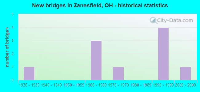
- New bridges - historical statistics
- 11930-1939
- 31960-1969
- 11970-1979
- 41990-1999
- 12000-2009

- Reconstructed bridges - Historical Statistics
- 11970-1979
- 21980-1989


- Bridge Condition - Deck
- 28.6%Excellent
- 28.6%Very good
- 28.6%Good
- 14.3%Satisfactory

- Bridge Condition - Superstructure
- 14.3%Excellent
- 71.4%Very good
- 14.3%Fair

- Bridge Condition - Substructure
- 14.3%Excellent
- 42.9%Very good
- 28.6%Good
- 14.3%Fair

- Bridge Condition - Channel
- 50.0%Excellent
- 33.3%Very good
- 16.7%Good
Find on map >> Show street view
Structure Number: 4600894, Location: 2.71MI. SE.OF JCT. SR-540 (Lat: 40.342061, Lng: -83.694481), Route carried "on" structure: County highway C0010, Year Built: 1995, Status: Open, Structure Length: 6.95m (22.80ft), Average Daily Traffic: 3,631 (year 2015), Truck Traffic: 8%, Average Future Daily Traffic: 25,908 (year 2035), Design Load: HS 20+Mod, Features Intersected: U.S. ROUTE 33, Facility Carried by Structure: COUNTY ROAD 10
Minimum Vertical Clearance: 30+ m (98+ ft), Kilometerpoint: 6.622, Lanes on structure: 2, Lanes under structure: 4, Owner: State Highway Agency, Approaching Roadway Width: 9.8m (32.2ft), Skew: 3 degrees, Material/Design: Steel continuous, Design/Construction: Stringer/Multi-beam, Number Of Spans In Main Unit: 2, Length of Maximum Span: 33.8m (110.9ft), Curb-To-Curb Width: 12.2m (40.0ft), Out-to-Out Width: 13.1m (43.0ft)
Condition: Deck: Very good, Superstructure: Very good, Substructure: Very good, Operating Rating: 42.1 metric tons, Method Used To Determine Operating Rating: Load Factor (LF) rating reported by rating factor (RF) method using MS18 loading, Inventory Rating: 32.4 metric tons, Method Used To Determine Inventory Rating: Load Factor (LF) rating reported by rating factor (RF) method using MS18 loading, Structural Evaluation: Equal to present desirable criteria, Deck Geometry: Equal to present minimum criteria, Underclear: Better than present minimum criteria, Approach Roadway Alignment: Equal to present desirable criteria, Designated Inspection Frequency: Every 24 months, Inspection Date: June 2021, Deck Structure Type: Concrete Cast-file-Place, Wearing Surface/Protective System: Wearing Surface: Monolithic Concrete, Deck Protection: Epoxy Coated Reinforcing
Find on map >> Show street view
Structure Number: 4600908, Location: 3.56MI.SE.OF JCT. SR-540 (Lat: 40.332419, Lng: -83.682761), Route carried "on" structure: US 33, Year Built: 1963, Year Reconstructed: 1993, Status: Open, Structure Length: 10.06m (33.01ft), Average Daily Traffic: 10,117 (year 2015), Truck Traffic: 18%, Average Future Daily Traffic: 14,042 (year 2035), Design Load: HL 93, Features Intersected: CR 5 & FISH POND CHANNEL
Minimum Vertical Clearance: 30+ m (98+ ft), Kilometerpoint: 33.474, Lanes on structure: 2, Lanes under structure: 2, Base Highway Network: Yes, Owner: State Highway Agency, Approaching Roadway Width: 13.4m (44.0ft), Skew: 2 degrees, Material/Design: Steel continuous, Design/Construction: Stringer/Multi-beam, Number Of Spans In Main Unit: 4, Length of Maximum Span: 27.4m (89.9ft), Curb-To-Curb Width: 12.8m (42.0ft), Out-to-Out Width: 13.8m (45.3ft)
Condition: Deck: Good, Superstructure: Very good, Substructure: Good, Channel: Very good, Operating Rating: 48.6 metric tons, Method Used To Determine Operating Rating: Load and Resistance Factor Rating (LRFR) rating reported by rating factor(RF) method using HL-93 loadings, Inventory Rating: 35.6 metric tons, Method Used To Determine Inventory Rating: Load and Resistance Factor Rating (LRFR) rating reported by rating factor(RF) method using HL-93 loadings, Structural Evaluation: Better than present minimum criteria, Deck Geometry: Equal to present desirable criteria, Underclear: Meets minimum limits, Waterway Adequacy: Superior to present desirable criteria, Approach Roadway Alignment: Equal to present desirable criteria, Designated Inspection Frequency: Every 24 months, Inspection Date: June 2021, Deck Structure Type: Concrete Cast-file-Place, Wearing Surface/Protective System: Wearing Surface: Monolithic Concrete, Deck Protection: Epoxy Coated Reinforcing
Find on map >> Show street view
Structure Number: 4600916, Location: 3.56MI.SE. OF JCT. SR-540 (Lat: 40.332189, Lng: -83.682861), Route carried "on" structure: US 33, Year Built: 1993, Status: Open, Structure Length: 10.03m (32.91ft), Average Daily Traffic: 10,117 (year 2015), Truck Traffic: 18%, Average Future Daily Traffic: 14,042 (year 2035), Design Load: HL 93, Features Intersected: CR-5 & FISH POND CHANNEL
Minimum Vertical Clearance: 30+ m (98+ ft), Kilometerpoint: 33.474, Lanes on structure: 2, Lanes under structure: 2, Base Highway Network: Yes, Owner: State Highway Agency, Approaching Roadway Width: 7.3m (24.0ft), Skew: 2 degrees, Material/Design: Steel continuous, Design/Construction: Stringer/Multi-beam, Number Of Spans In Main Unit: 4, Length of Maximum Span: 27.4m (89.9ft), Curb-To-Curb Width: 12.8m (42.0ft), Out-to-Out Width: 13.8m (45.3ft)
Condition: Deck: Good, Superstructure: Very good, Substructure: Very good, Channel: Very good, Operating Rating: 45.4 metric tons, Method Used To Determine Operating Rating: Load and Resistance Factor Rating (LRFR) rating reported by rating factor(RF) method using HL-93 loadings, Inventory Rating: 35.6 metric tons, Method Used To Determine Inventory Rating: Load and Resistance Factor Rating (LRFR) rating reported by rating factor(RF) method using HL-93 loadings, Structural Evaluation: Equal to present desirable criteria, Deck Geometry: Equal to present desirable criteria, Underclear: Meets minimum limits, Waterway Adequacy: Superior to present desirable criteria, Approach Roadway Alignment: Equal to present desirable criteria, Designated Inspection Frequency: Every 24 months, Inspection Date: June 2021, Deck Structure Type: Concrete Cast-file-Place, Wearing Surface/Protective System: Wearing Surface: Monolithic Concrete, Deck Protection: Epoxy Coated Reinforcing
Find on map >> Show street view
Structure Number: 4600932, Location: 3.87MI.SE.OF JCT. SR-540 (Lat: 40.329339, Lng: -83.678661), Route carried "on" structure: US 33, Year Built: 1963, Year Reconstructed: 1993, Status: Open, Structure Length: 3.08m (10.10ft), Average Daily Traffic: 10,117 (year 2015), Truck Traffic: 18%, Average Future Daily Traffic: 14,042 (year 2035), Design Load: HS 20+Mod, Features Intersected: MAD RIVER
Minimum Vertical Clearance: 30+ m (98+ ft), Kilometerpoint: 33.941, Lanes on structure: 2, Base Highway Network: Yes, Owner: State Highway Agency, Approaching Roadway Width: 11.6m (38.1ft), Material/Design: Concrete continuous, Design/Construction: Slab, Number Of Spans In Main Unit: 3, Length of Maximum Span: 11.6m (38.1ft), Curb-To-Curb Width: 13.4m (44.0ft), Out-to-Out Width: 13.4m (44.0ft)
Condition: Deck: Very good, Superstructure: Very good, Substructure: Good, Channel: Good, Operating Rating: 42.1 metric tons, Method Used To Determine Operating Rating: Load Factor (LF) rating reported by rating factor (RF) method using MS18 loading, Inventory Rating: 32.4 metric tons, Method Used To Determine Inventory Rating: Load Factor (LF) rating reported by rating factor (RF) method using MS18 loading, Structural Evaluation: Better than present minimum criteria, Deck Geometry: Superior to present desirable criteria, Waterway Adequacy: Equal to present desirable criteria, Approach Roadway Alignment: Equal to present desirable criteria, Designated Inspection Frequency: Every 24 months, Inspection Date: May 2021, Deck Structure Type: Concrete Cast-file-Place, Wearing Surface/Protective System: Wearing Surface: Monolithic Concrete, Deck Protection: Epoxy Coated Reinforcing
Find on map >> Show street view
Structure Number: 4630459, Location: .01 M N OF CR 25 (Lat: 40.350000, Lng: -83.675000), Route carried "on" structure: County highway C0005, Year Built: 1934, Year Reconstructed: 1970, Status: Open, Structure Length: 1.34m (4.40ft), Average Daily Traffic: 731 (year 2015), Truck Traffic: 8%, Average Future Daily Traffic: 1,015 (year 2035), Design Load: H 15, Features Intersected: MAD RIVER, Facility Carried by Structure: CR 5
Minimum Vertical Clearance: 30+ m (98+ ft), Kilometerpoint: 12.971, Lanes on structure: 2, Owner: County Highway Agency, Approaching Roadway Width: 7.9m (25.9ft), Skew: 3 degrees, Material/Design: Concrete, Design/Construction: Tee Beam, Number Of Spans In Main Unit: 1, Length of Maximum Span: 12.8m (42.0ft), Curb or Sidewalk Widths: Left: 0.2m (0.7ft), Right: 0.2m (0.7ft), Curb-To-Curb Width: 7.3m (24.0ft), Out-to-Out Width: 8.5m (27.9ft)
Condition: Deck: Satisfactory, Superstructure: Fair, Substructure: Fair, Channel: Excellent, Operating Rating: 45.4 metric tons, Method Used To Determine Operating Rating: Load Factor (LF) rating reported by rating factor (RF) method using MS18 loading, Inventory Rating: 19.4 metric tons, Method Used To Determine Inventory Rating: Load Factor (LF) rating reported by rating factor (RF) method using MS18 loading, Structural Evaluation: Somewhat better than minimum adequacy, Deck Geometry: Meets minimum limits, Waterway Adequacy: Equal to present desirable criteria, Approach Roadway Alignment: Equal to present desirable criteria, Designated Inspection Frequency: Every 12 months, Inspection Date: December 2021, Deck Structure Type: Concrete Cast-file-Place, Wearing Surface/Protective System: Wearing Surface: Bituminous
Find on map >> Show street view
Structure Number: 4630858, Location: .24 M E OF CR 5 (Lat: 40.338331, Lng: -83.666669), Route carried "on" structure: County highway C0010, Year Built: 1971, Status: Open, Structure Length: 2.50m (8.20ft), Average Daily Traffic: 492 (year 2015), Truck Traffic: 8%, Average Future Daily Traffic: 683 (year 2035), Design Load: HS 15, Features Intersected: MAD RIVER, Facility Carried by Structure: CR 10
Minimum Vertical Clearance: 30+ m (98+ ft), Kilometerpoint: 8.143, Lanes on structure: 2, Owner: County Highway Agency, Approaching Roadway Width: 9.1m (29.9ft), Material/Design: Concrete continuous, Design/Construction: Slab, Number Of Spans In Main Unit: 3, Length of Maximum Span: 9.1m (29.9ft), Curb-To-Curb Width: 9.1m (29.9ft), Out-to-Out Width: 9.1m (29.9ft)
Condition: Deck: Excellent, Superstructure: Excellent, Substructure: Very good, Channel: Excellent, Operating Rating: 55.1 metric tons, Method Used To Determine Operating Rating: Load Factor (LF) rating reported by rating factor (RF) method using MS18 loading, Inventory Rating: 32.4 metric tons, Method Used To Determine Inventory Rating: Load Factor (LF) rating reported by rating factor (RF) method using MS18 loading, Structural Evaluation: Equal to present desirable criteria, Deck Geometry: Equal to present minimum criteria, Waterway Adequacy: Equal to present desirable criteria, Approach Roadway Alignment: Equal to present desirable criteria, Designated Inspection Frequency: Every 24 months, Inspection Date: December 2021, Deck Structure Type: Concrete Cast-file-Place, Wearing Surface/Protective System: Wearing Surface: Bituminous
Find on map >> Show street view
Structure Number: 4644506, Location: 0.23 MI E OF CR 5 (Lat: 40.335539, Lng: -83.673811), Route carried "on" structure: County highway C0153, Year Built: 2006, Status: Open, Structure Length: 2.59m (8.50ft), Average Daily Traffic: 1,553 (year 2015), Truck Traffic: 7%, Average Future Daily Traffic: 2,156 (year 2035), Design Load: HS 20+Mod, Features Intersected: MAD RIVER, Facility Carried by Structure: CR 153
Minimum Vertical Clearance: 30+ m (98+ ft), Kilometerpoint: 0.354, Lanes on structure: 2, Owner: County Highway Agency, Approaching Roadway Width: 7.3m (24.0ft), Material/Design: Prestressed concrete, Design/Construction: Box Beam or Girders - Multiple, Number Of Spans In Main Unit: 1, Length of Maximum Span: 25.9m (85.0ft), Curb-To-Curb Width: 7.3m (24.0ft), Out-to-Out Width: 7.3m (24.0ft)
Condition: Deck: Excellent, Superstructure: Very good, Substructure: Excellent, Channel: Excellent, Operating Rating: 90.7 metric tons, Method Used To Determine Operating Rating: Load Factor (LF) rating reported by rating factor (RF) method using MS18 loading, Inventory Rating: 55.1 metric tons, Method Used To Determine Inventory Rating: Load Factor (LF) rating reported by rating factor (RF) method using MS18 loading, Structural Evaluation: Equal to present desirable criteria, Deck Geometry: Meets minimum limits, Waterway Adequacy: Equal to present desirable criteria, Approach Roadway Alignment: Equal to present desirable criteria, Designated Inspection Frequency: Every 24 months, Inspection Date: December 2021, Deck Structure Type: Concrete Cast-file-Place, Wearing Surface/Protective System: Wearing Surface: Bituminous, Membrane: Epoxy, Deck Protection: Epoxy Coated Reinforcing
Find on map >> Show street view
Structure Number: 4600894, Location: 2.71MI. SE.OF JCT. SR-540 (Lat: 40.342061, Lng: -83.694481), Route carried "under" structure: US 33, Year Built: 1995, Structure Length: 0. m, Average Daily Traffic: 18,666 (year 2015), Truck Traffic: 19%, Features Intersected: COUNTY ROAD 10, Facility Carried by Structure: COUNTY ROAD 10
Minimum Vertical Clearance: 5.97m (19.59ft), Kilometerpoint: 31.994, Lanes on structure: 2, Lanes under structure: 4, Material/Design: Steel continuous, Design/Construction: Stringer/Multi-beam, Length of Maximum Span: 33.8m (110.9ft)
Find on map >> Show street view
Structure Number: 4600908, Location: 3.56MI.SE.OF JCT. SR-540 (Lat: 40.332419, Lng: -83.682761), Route carried "under" structure: County highway 5, Year Built: 1963, Structure Length: 0. m, Average Daily Traffic: 1,846 (year 2015), Truck Traffic: 7%, Features Intersected: USR 33, Facility Carried by Structure: USR 33
Minimum Vertical Clearance: 11.58m (37.99ft), Kilometerpoint: 0.612, Lanes on structure: 2, Lanes under structure: 2, Material/Design: Steel continuous, Design/Construction: Stringer/Multi-beam, Length of Maximum Span: 27.4m (89.9ft)
Find on map >> Show street view
Structure Number: 4600916, Location: 3.56MI.SE. OF JCT. SR-540 (Lat: 40.332189, Lng: -83.682861), Route carried "under" structure: County highway 5, Year Built: 1993, Structure Length: 0. m, Average Daily Traffic: 1,846 (year 2015), Truck Traffic: 7%, Features Intersected: USR-33, Facility Carried by Structure: USR 33
Minimum Vertical Clearance: 10.06m (33.01ft), Kilometerpoint: 0.612, Lanes on structure: 2, Lanes under structure: 2, Material/Design: Steel continuous, Design/Construction: Stringer/Multi-beam, Length of Maximum Span: 27.4m (89.9ft)