Alberta, Alabama
Submit your own pictures of this place and show them to the world
- OSM Map
- General Map
- Google Map
- MSN Map

| Males: 733 | |
| Females: 899 |
| Median resident age: | 31.2 years |
| Alabama median age: | 35.8 years |
Zip code: 36728
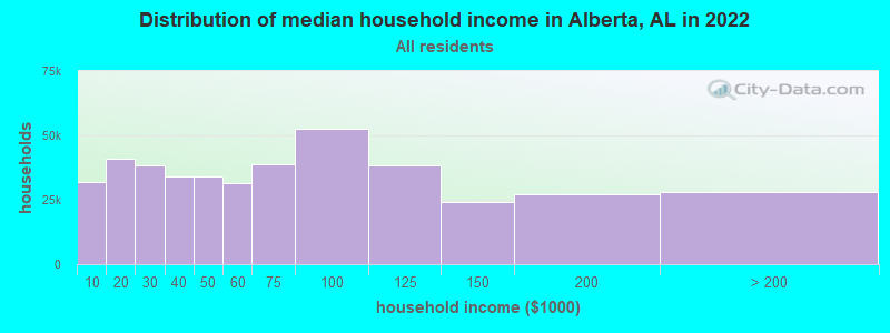
| Alberta: | $32,673 |
| AL: | $59,674 |
Estimated per capita income in 2022: $12,254 (it was $6,452 in 2000)
Alberta CCD income, earnings, and wages data
Estimated median house or condo value in 2022: $86,331 (it was $36,600 in 2000)
| Alberta: | $86,331 |
| AL: | $200,900 |
Mean prices in 2022: all housing units: $110,504; detached houses: $155,599; mobile homes: $41,921
Detailed information about poverty and poor residents in Alberta, AL


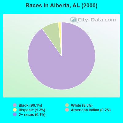
- 1,51790.1%Black alone
- 1408.3%White alone
- 211.2%Hispanic
- 40.2%American Indian alone
- 20.1%Two or more races
According to our research of Alabama and other state lists, there were 2 registered sex offenders living in Alberta, Alabama as of May 15, 2024.
The ratio of all residents to sex offenders in Alberta is 816 to 1.
The ratio of registered sex offenders to all residents in this city is lower than the state average.
 Recent articles from our blog. Our writers, many of them Ph.D. graduates or candidates, create easy-to-read articles on a wide variety of topics.
Current Local Time: CST time zone
Elevation: 205 feet
Land area: 155.6 square miles.
Population density: 10 people per square mile (very low).

| Alberta CCD: | 0.5% ($199) |
| Alabama: | 0.4% ($289) |
Nearest city with pop. 50,000+: Montgomery, AL  (67.1 miles , pop. 201,568).
Nearest city with pop. 1,000,000+: Houston, TX (501.4 miles , pop. 1,953,631).
Nearest cities:
), ), ), )Latitude: 32.16 N, Longitude: 87.40 W
Area code: 334

| Here: | 9.3% |
| Alabama: | 2.6% |
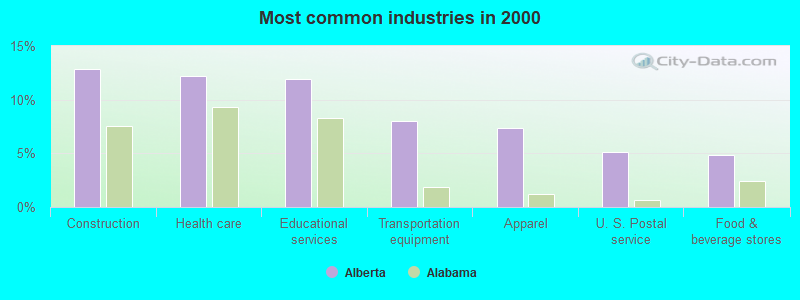
- Construction (12.9%)
- Health care (12.2%)
- Educational services (11.9%)
- Transportation equipment (8.0%)
- Apparel (7.4%)
- U. S. Postal service (5.1%)
- Food & beverage stores (4.8%)
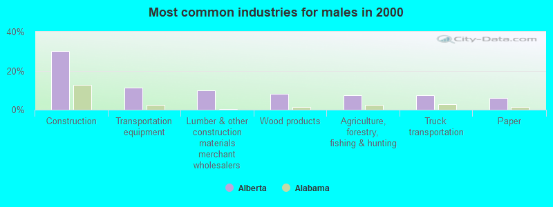
- Construction (30.1%)
- Transportation equipment (11.3%)
- Lumber & other construction materials merchant wholesalers (9.8%)
- Wood products (8.3%)
- Agriculture, forestry, fishing & hunting (7.5%)
- Truck transportation (7.5%)
- Paper (6.0%)
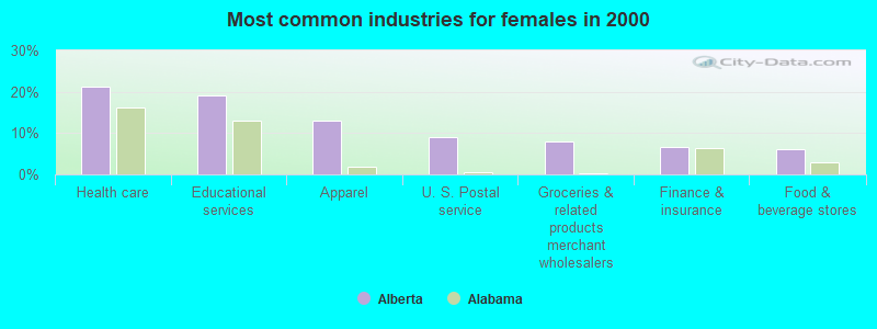
- Health care (21.3%)
- Educational services (19.1%)
- Apparel (12.9%)
- U. S. Postal service (9.0%)
- Groceries & related products merchant wholesalers (7.9%)
- Finance & insurance (6.7%)
- Food & beverage stores (6.2%)
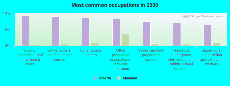
- Nursing, psychiatric, and home health aides (9.3%)
- Textile, apparel, and furnishings workers (9.0%)
- Construction laborers (8.7%)
- Other production occupations, including supervisors (8.4%)
- Cooks and food preparation workers (7.4%)
- Preschool, kindergarten, elementary, and middle school teachers (7.1%)
- Supervisors, construction and extraction workers (6.4%)
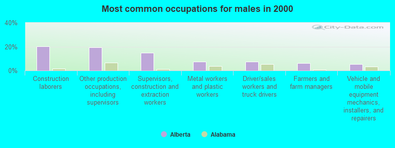
- Construction laborers (20.3%)
- Other production occupations, including supervisors (19.5%)
- Supervisors, construction and extraction workers (15.0%)
- Metal workers and plastic workers (7.5%)
- Driver/sales workers and truck drivers (7.5%)
- Farmers and farm managers (6.0%)
- Vehicle and mobile equipment mechanics, installers, and repairers (5.3%)
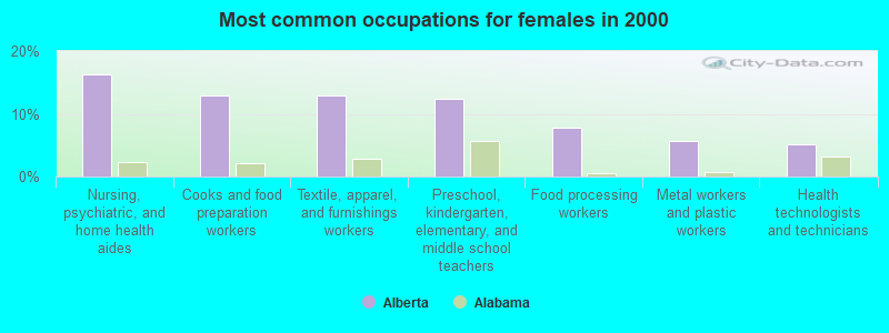
- Nursing, psychiatric, and home health aides (16.3%)
- Cooks and food preparation workers (12.9%)
- Textile, apparel, and furnishings workers (12.9%)
- Preschool, kindergarten, elementary, and middle school teachers (12.4%)
- Food processing workers (7.9%)
- Metal workers and plastic workers (5.6%)
- Health technologists and technicians (5.1%)
Average climate in Alberta, Alabama
Based on data reported by over 4,000 weather stations


Tornado activity:
Alberta-area historical tornado activity is below Alabama state average. It is 21% greater than the overall U.S. average.
On 3/1/2007, a category F4 (max. wind speeds 207-260 mph) tornado 2.6 miles away from the Alberta place center killed one person and injured 2 people and caused $2 million in damages.
On 5/27/1973, a category F4 tornado 34.8 miles away from the place center killed 7 people and injured 199 people and caused between $5,000,000 and $50,000,000 in damages.
Earthquake activity:
Alberta-area historical earthquake activity is significantly above Alabama state average. It is 93% greater than the overall U.S. average.On 10/24/1997 at 08:35:17, a magnitude 4.9 (4.8 MB, 4.2 MS, 4.9 LG, Depth: 6.2 mi, Class: Light, Intensity: IV - V) earthquake occurred 71.9 miles away from the city center
On 1/18/1999 at 07:00:53, a magnitude 4.8 (4.8 MB, 4.0 LG, Depth: 0.6 mi) earthquake occurred 86.7 miles away from Alberta center
On 11/7/2004 at 11:20:21, a magnitude 4.3 (4.3 MW, Depth: 3.1 mi) earthquake occurred 46.1 miles away from the city center
On 4/29/2003 at 08:59:39, a magnitude 4.9 (4.4 MB, 4.6 MW, 4.9 LG) earthquake occurred 191.3 miles away from the city center
On 6/24/1975 at 11:11:36, a magnitude 4.5 (4.5 MB) earthquake occurred 111.0 miles away from Alberta center
On 4/29/2003 at 08:59:39, a magnitude 4.6 (4.6 MW, Depth: 12.3 mi) earthquake occurred 191.3 miles away from the city center
Magnitude types: regional Lg-wave magnitude (LG), body-wave magnitude (MB), surface-wave magnitude (MS), moment magnitude (MW)
Natural disasters:
The number of natural disasters in Wilcox County (16) is near the US average (15).Major Disasters (Presidential) Declared: 8
Emergencies Declared: 5
Causes of natural disasters: Hurricanes: 6, Storms: 6, Floods: 5, Tornadoes: 5, Winds: 2, Drought: 1, Snowfall: 1, Winter Storm: 1, Other: 1 (Note: some incidents may be assigned to more than one category).
Colleges/universities with over 2000 students nearest to Alberta:
- University of West Alabama (about 55 miles; Livingston, AL; Full-time enrollment: 3,394)
- Alabama State University (about 67 miles; Montgomery, AL; FT enrollment: 5,457)
- Shelton State Community College (about 68 miles; Tuscaloosa, AL; FT enrollment: 4,106)
- Faulkner University (about 72 miles; Montgomery, AL; FT enrollment: 2,887)
- University of Montevallo (about 73 miles; Montevallo, AL; FT enrollment: 2,826)
- Auburn University at Montgomery (about 74 miles; Montgomery, AL; FT enrollment: 4,092)
- The University of Alabama (about 74 miles; Tuscaloosa, AL; FT enrollment: 30,931)
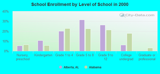
Public elementary/middle school in Alberta:
- ABC ELEM (Students: 180, Location: 3000 COUNTY ROAD 29, Grades: PK-6)
Points of interest:
Notable locations in Alberta: South Hall Landing (A), Proctor Landing (B), Gees Bend Access Point (C). Display/hide their locations on the map
Churches in Alberta include: Mount Olive Church (A), Pleasant Grove Church (B), Oak Grove Church (C), Pine Grove Church (D), Prairie Mission Church (E), Zion Church (F), Signature Church (G), Oak Grove Church (H), Mount Sinia Church (I). Display/hide their locations on the map
Cemeteries: Cobbs Cemetery (1), McMillan Cemetery (2), Oak Grove Cemetery (3), Shell Creek Cemetery (4), Mendenhall Cemetery (5), Cooper Cemetery (6), Hotel Cemetery (7). Display/hide their locations on the map
Reservoir: Joe Harrison Lake (A). Display/hide its location on the map
Streams, rivers, and creeks: Slater Branch (A), Red Creek (B), Mill Creek (C), Little Chilatchee Creek (D), Foster Creek (E), Dixon Creek (F), William Creek (G), Beaver Creek (H). Display/hide their locations on the map
Parks in Alberta include: Clifton Ferry Public Use Area (1), Chilatchee Park (2), Shell Creek Park (3). Display/hide their locations on the map
Birthplace of: Marie Foster - African s' rights activist.
| This place: | 2.7 people |
| Alabama: | 2.5 people |
| This place: | 68.6% |
| Whole state: | 67.8% |
| This place: | 5.2% |
| Whole state: | 4.7% |
Likely homosexual households (counted as self-reported same-sex unmarried-partner households)
- Lesbian couples: 0.0% of all households
- Gay men: 0.2% of all households
| This place: | 46.3% |
| Whole state: | 16.1% |
| This place: | 30.2% |
| Whole state: | 7.3% |
For population 15 years and over in Alberta:
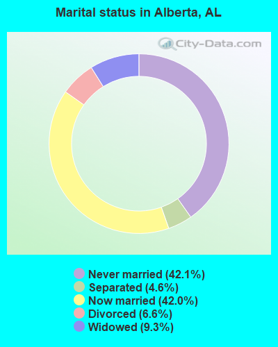
- Never married: 42.1%
- Now married: 42.0%
- Separated: 4.6%
- Widowed: 9.3%
- Divorced: 6.6%
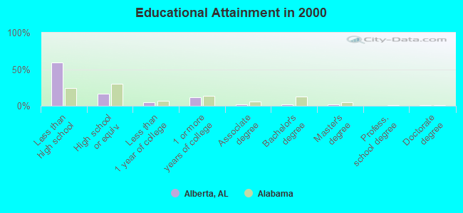
For population 25 years and over in Alberta:
- High school or higher: 40.6%
- Bachelor's degree or higher: 4.8%
- Graduate or professional degree: 2.8%
- Unemployed: 19.0%
- Mean travel time to work (commute): 51.9 minutes
| Here: | 20.8 |
| Alabama average: | 13.2 |
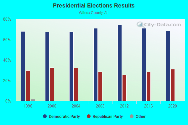
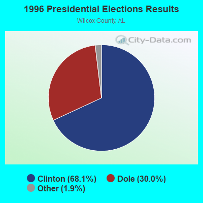
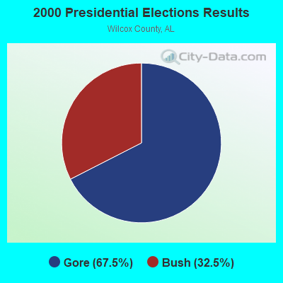
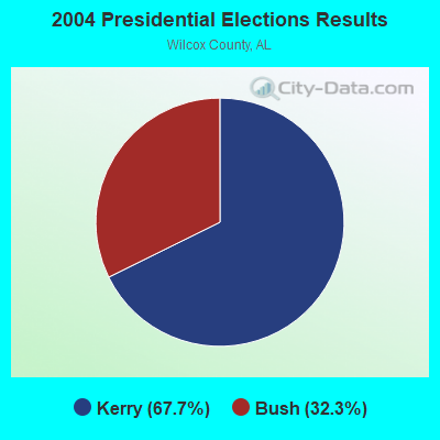
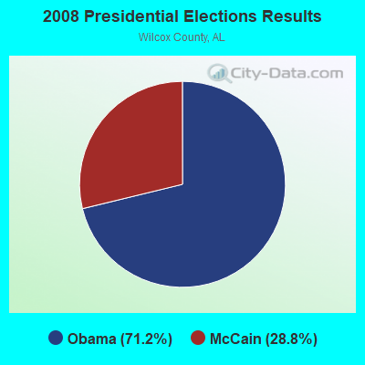
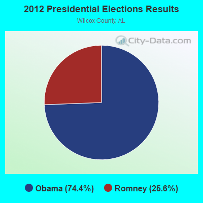
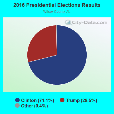
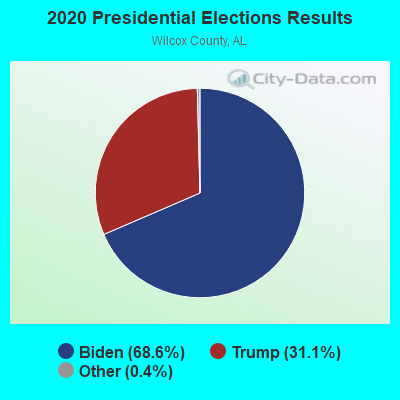
Graphs represent county-level data. Detailed 2008 Election Results
Religion statistics for Alberta, AL (based on Wilcox County data)
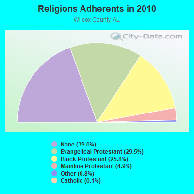
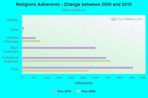
| Religion | Adherents | Congregations |
|---|---|---|
| Evangelical Protestant | 3,442 | 34 |
| Black Protestant | 3,007 | 25 |
| Mainline Protestant | 568 | 8 |
| Other | 95 | 2 |
| Catholic | 12 | 3 |
| None | 4,546 | - |
Food Environment Statistics:
| Wilcox County: | 7.05 / 10,000 pop. |
| Alabama: | 1.89 / 10,000 pop. |
| Wilcox County: | 0.78 / 10,000 pop. |
| Alabama: | 0.65 / 10,000 pop. |
| Wilcox County: | 6.27 / 10,000 pop. |
| State: | 6.32 / 10,000 pop. |
| Here: | 3.92 / 10,000 pop. |
| State: | 5.75 / 10,000 pop. |
| This county: | 16.2% |
| Alabama: | 11.8% |
| Wilcox County: | 39.4% |
| Alabama: | 31.7% |
| This county: | 15.6% |
| State: | 13.5% |
Strongest AM radio stations in Alberta:
- WJOX (690 AM; 50 kW; BIRMINGHAM, AL; Owner: CITADEL BROADCASTING COMPANY)
- WASG (550 AM; 25 kW; ATMORE, AL; Owner: 550 AM, INC)
- WDJC (850 AM; 50 kW; BIRMINGHAM, AL; Owner: KIMTRON, INC.)
- WAPI (1070 AM; 50 kW; BIRMINGHAM, AL; Owner: CITADEL BROADCASTING COMPANY)
- WCOX (1450 AM; 1 kW; CAMDEN, AL; Owner: DOWN HOME BROADCASTING)
- WJUS (1310 AM; 5 kW; MARION, AL; Owner: GRACE BAPTIST TEMPLE CHURCH)
- WSJC (810 AM; 50 kW; MAGEE, MS; Owner: FAMILY TALK RADIO)
- WNSI (810 AM; 50 kW; JACKSONVILLE, AL; Owner: UNITED BROADCASTING NETWORK, INC.)
- WYNI (930 AM; 5 kW; MONROEVILLE, AL; Owner: MCKISSICK ENTERPRISES)
- WMSP (740 AM; 10 kW; MONTGOMERY, AL; Owner: CUMULUS LICENSING CORP.)
- WCPC (940 AM; 50 kW; HOUSTON, MS; Owner: WCPC BROADCASTING CO., INC.)
- WYLS (670 AM; daytime; 5 kW; YORK, AL; Owner: GRANTELL BROADCASTING COMPANY)
- WJDB (630 AM; 1 kW; THOMASVILLE, AL; Owner: GRIFFIN BROADCASTING CORPORATION)
Strongest FM radio stations in Alberta:
- WKXK (96.7 FM; PINE HILL, AL; Owner: AUTAUGAVILLE RADIO, INC.)
- WBFZ (105.3 FM; SELMA, AL; Owner: IMANI COMMUNICATIONS CORPORATION, INC)
- WINL (98.5 FM; LINDEN, AL; Owner: WEST ALABAMA COMMUNICATIONS, INC.)
- WVFG (107.5 FM; UNIONTOWN, AL; Owner: CHARLES E. JONES, JR.)
- WMBV (91.9 FM; DIXONS MILLS, AL; Owner: THE MOODY BIBLE INSTITUTE OF CHICAGO)
- WAPR (88.3 FM; SELMA, AL; Owner: UA-ASU-TSU EDUCATIONAL RADIO CORP.)
- WYVC (102.3 FM; CAMDEN, AL; Owner: DOWN HOME BROADCASTING)
- WJAM-FM (97.3 FM; ORRVILLE, AL; Owner: SCOTT COMMUNICATIONS, INC.)
- WNPT-FM (102.9 FM; LINDEN, AL; Owner: BECKHAM PALMER III AS RECEIVER)
- WALX (100.9 FM; SELMA, AL; Owner: ALEXANDER BROADCASTING COMPANY, INC.)
TV broadcast stations around Alberta:
- WAKA (Channel 8; SELMA, AL; Owner: ALABAMA BROADCASTING PARTNERS)
- WIIQ (Channel 41; DEMOPOLIS, AL; Owner: ALABAMA EDUCATIONAL TELEVISION COMMISSION)
- WBIH (Channel 29; SELMA, AL; Owner: FLINN BROADCASTING CORPORATION)
FCC Registered Antenna Towers:
15 (See the full list of FCC Registered Antenna Towers in Alberta)FCC Registered Microwave Towers:
2- BOYKIN 11, 9828 County Road 29 (Lat: 32.098083 Lon: -87.314806), Type: Ltower, Structure height: 76.2 m, Overall height: 77.7 m, Call Sign: WQUN921,
Assigned Frequencies: 10775.0 MHz, Grant Date: 08/28/2014, Expiration Date: 08/28/2024, Cancellation Date: 10/23/2014, Certifier: John E Monday, Registrant: At&t Mobility LLC, 3300 E. Renner Road #b3132, Richardson, TX 75082, Phone: (855) 699-7073, Fax: (972) 907-1131, Email:
- BOYKIN, 11001 County Rd 29 (Lat: 32.096722 Lon: -87.311083), Type: Gtower, Structure height: 99.1 m, Overall height: 101.2 m, Call Sign: WRUG984,
Assigned Frequencies: 6315.84 MHz, 6375.14 MHz, 6404.79 MHz, Grant Date: 08/25/2022, Expiration Date: 08/25/2032, Certifier: Cecil J Mathew, Registrant: At&t Services, Inc., 208 S Akard St, 20f, Dallas, TX 75202, Phone: (855) 699-7073, Email:
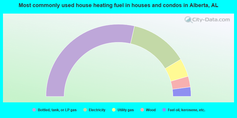
- 57.1%Bottled, tank, or LP gas
- 25.7%Electricity
- 8.2%Utility gas
- 4.8%Wood
- 4.2%Fuel oil, kerosene, etc.
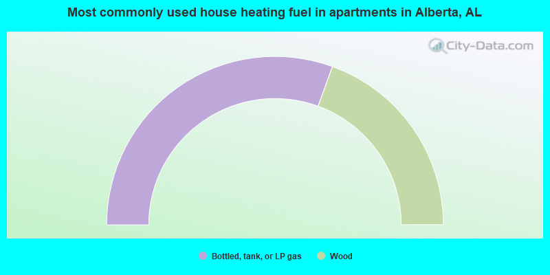
- 61.1%Bottled, tank, or LP gas
- 38.9%Wood
Alberta compared to Alabama state average:
- Median household income below state average.
- Median house value significantly below state average.
- Black race population percentage significantly above state average.
- Hispanic race population percentage significantly below state average.
- Median age significantly below state average.
- Foreign-born population percentage significantly below state average.
- Renting percentage below state average.
- Length of stay since moving in significantly above state average.
- Number of rooms per house significantly below state average.
- House age significantly below state average.
- Number of college students below state average.
- Percentage of population with a bachelor's degree or higher significantly below state average.
Alberta on our top lists:
- #51 on the list of "Top 100 cities with longest commuting times"
- #79 on the list of "Top 101 cities with the least cars per house, population 500+"
- #44 on the list of "Top 101 counties with the smallest number of children under 18 without health insurance coverage in 2000"
- #60 on the list of "Top 101 counties with highest percentage of residents voting for Obama (Democrat) in the 2012 Presidential Election"
- #70 on the list of "Top 101 counties with the smallest number of people without health insurance coverage in 2000"