Alstead, New Hampshire
Submit your own pictures of this town and show them to the world
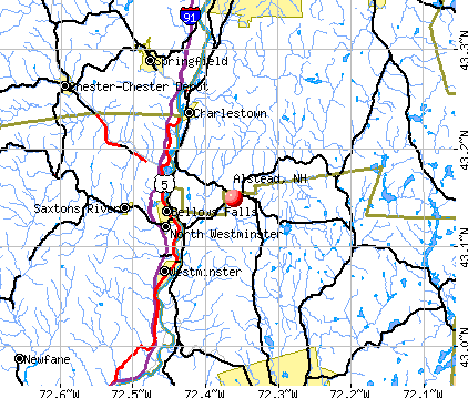
- OSM Map
- General Map
- Google Map
- MSN Map
Population change since 2000: -0.4%
 |
| Males: 959 | |
| Females: 978 |
| Median resident age: | 44.5 years |
| New Hampshire median age: | 43.9 years |
Zip codes: 03602.
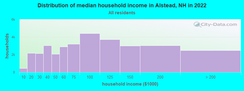
| Alstead: | $79,241 |
| NH: | $89,992 |
Estimated per capita income in 2022: $41,134 (it was $20,444 in 2000)
Alstead town income, earnings, and wages data
Estimated median house or condo value in 2022: $236,020 (it was $91,100 in 2000)
| Alstead: | $236,020 |
| NH: | $384,700 |
Mean prices in 2022: all housing units: $286,446; detached houses: $308,243; townhouses or other attached units: $255,194; in 2-unit structures: $255,554; in 3-to-4-unit structures: $346,438; in 5-or-more-unit structures: $233,006; mobile homes: $69,259
Detailed information about poverty and poor residents in Alstead, NH
Compare current foreclosures near Alstead, NH:
| Photo | Address | Area | Beds / Baths | Price | Details |
|---|---|---|---|---|---|

|
#1
River St
Alstead, NH 03602
|
- sq. feet
|
- baths - beds |
show details | |

|
#2
Library Ave
Alstead, NH 03602
|
- sq. feet
|
- baths - beds |
show details | |

|
#3
Baine Way
Alstead, NH 03602
|
- sq. feet
|
- baths - beds |
show details | |

|
#4
Gilsum Mine Rd
Alstead, NH 03602
|
- sq. feet
|
- baths - beds |
show details | |

|
#5
Dutton District Rd
Springfield, VT 05156
|
1,770 sq. feet
|
1 baths 3 beds |
show details | |

|
#6
Byrd Ave
Claremont, NH 03743
|
1,021 sq. feet
|
1 baths 3 beds |
show details | |

|
#7
2nd Nh Tpke
Claremont, NH 03743
|
1,974 sq. feet
|
1 baths 3 beds |
show details | |

|
#8
Laura Ln
Keene, NH 03431
|
912 sq. feet
|
1 baths 3 beds |
show details | |

|
#9
James St
Charlestown, NH 03603
|
1,032 sq. feet
|
2 baths 2 beds |
show details | |

|
#10
N Shore Rd
Spofford, NH 03462
|
- sq. feet
|
2 baths 3 beds |
show details |
| Photo | Address | Area | Beds / Baths | Price | Details |
|---|---|---|---|---|---|

|
#11
Morways Park
Charlestown, NH 03603
|
1,064 sq. feet
|
2 baths 2 beds |
show details | |

|
#12
Old Springfield Rd
Charlestown, NH 03603
|
1,848 sq. feet
|
1 baths 4 beds |
show details | |

|
#13
Taylor Hill Rd
Charlestown, NH 03603
|
2,226 sq. feet
|
2 baths 4 beds |
show details | |

|
#14
Acworth Rd
Charlestown, NH 03603
|
1,826 sq. feet
|
1 baths 3 beds |
show details | |

|
#15
Pine Grove St
Claremont, NH 03743
|
2,304 sq. feet
|
1 baths 3 beds |
show details | |

|
#16
Washington St
Keene, NH 03431
|
- sq. feet
|
1 baths 3 beds |
show details | |

|
#17
Washington St
Keene, NH 03431
|
- sq. feet
|
1 baths 3 beds |
show details | |

|
#18
Howard St # 2
Keene, NH 03431
|
- sq. feet
|
2 baths 3 beds |
show details | |

|
#19
Franklin St Frnt A
Claremont, NH 03743
|
- sq. feet
|
- baths - beds |
show details | |

|
#20
Dogwood Ln
Springfield, VT 05156
|
- sq. feet
|
- baths - beds |
show details |
| Photo | Address | Area | Beds / Baths | Price | Details |
|---|---|---|---|---|---|

|
#21
Blood Rd
Newport, NH 03773
|
- sq. feet
|
- baths - beds |
show details | |

|
#22
Birch St
Keene, NH 03431
|
- sq. feet
|
- baths - beds |
show details | |

|
#23
Washington St
Keene, NH 03431
|
- sq. feet
|
- baths - beds |
show details | |

|
#24
Tigola Trl
Stoddard, NH 03464
|
- sq. feet
|
- baths - beds |
show details | |

|
#25
Spring St Apt 1
Keene, NH 03431
|
- sq. feet
|
- baths - beds |
show details | |

|
#26
Emerald St # 194
Keene, NH 03431
|
- sq. feet
|
- baths - beds |
show details | |

|
#27
Edgebrook Park
Bellows Falls, VT 05101
|
- sq. feet
|
- baths - beds |
show details | |

|
#28
Court St Apt I
Keene, NH 03431
|
- sq. feet
|
- baths - beds |
show details | |

|
#29
Westview Ter
Springfield, VT 05156
|
- sq. feet
|
- baths - beds |
show details | |

|
#30
Hubbard Rd
Sullivan, NH 03445
|
- sq. feet
|
- baths - beds |
show details |
| Photo | Address | Area | Beds / Baths | Price | Details |
|---|---|---|---|---|---|

|
#31
Center St
North Walpole, NH 03609
|
- sq. feet
|
- baths - beds |
show details | |

|
#32
N Shore R 2
Spofford, NH 03462
|
- sq. feet
|
- baths - beds |
show details | |

|
#33
Main St
Marlborough, NH 03455
|
- sq. feet
|
- baths - beds |
show details | |

|
#34
Murdough Hill Rd
Nelson, NH 03457
|
- sq. feet
|
- baths - beds |
show details | |

|
#35
Taylor Dr
Springfield, VT 05156
|
- sq. feet
|
- baths - beds |
show details | |

|
#36
Ayers Pond Rd
Washington, NH 03280
|
- sq. feet
|
- baths - beds |
show details | |

|
#37
Chapman Rd
Keene, NH 03431
|
- sq. feet
|
- baths - beds |
show details | |

|
#38
Paine Rd
Westmoreland, NH 03467
|
- sq. feet
|
- baths - beds |
show details | |

|
#39
Granite Lake Rd
Nelson, NH 03457
|
- sq. feet
|
- baths - beds |
show details | |

|
#40
Old Harrisville Rd
Marlborough, NH 03455
|
- sq. feet
|
- baths - beds |
show details |
| Photo | Address | Area | Beds / Baths | Price | Details |
|---|---|---|---|---|---|

|
Check over 1 million property listings on Foreclosure.com!
|
browse all offers | |||
| Photo | Address | Area | Beds / Baths | Price | Details |
|---|

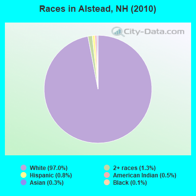
- 1,87897.0%White alone
- 261.3%Two or more races
- 160.8%Hispanic
- 90.5%American Indian alone
- 60.3%Asian alone
- 20.1%Black alone
Races in Alstead detailed stats: ancestries, foreign born residents, place of birth
According to our research of New Hampshire and other state lists, there were 3 registered sex offenders living in Alstead, New Hampshire as of May 17, 2024.
The ratio of all residents to sex offenders in Alstead is 646 to 1.
The ratio of registered sex offenders to all residents in this city is lower than the state average.
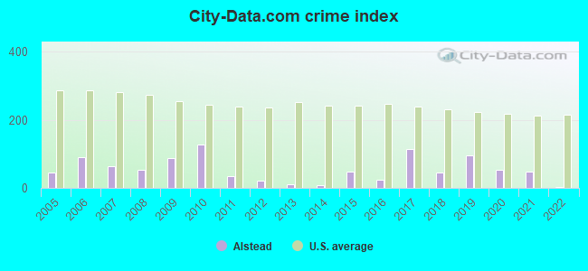
Type |
2009 |
2010 |
2011 |
2012 |
2013 |
2014 |
2015 |
2016 |
2017 |
2018 |
2019 |
2020 |
2021 |
2022 |
|---|---|---|---|---|---|---|---|---|---|---|---|---|---|---|
| Murders (per 100,000) | 0 (0.0) | 0 (0.0) | 0 (0.0) | 0 (0.0) | 0 (0.0) | 0 (0.0) | 0 (0.0) | 0 (0.0) | 1 (52.8) | 0 (0.0) | 0 (0.0) | 0 (0.0) | 0 (0.0) | 0 (0.0) |
| Rapes (per 100,000) | 1 (47.3) | 1 (51.6) | 0 (0.0) | 0 (0.0) | 0 (0.0) | 0 (0.0) | 0 (0.0) | 0 (0.0) | 0 (0.0) | 1 (52.6) | 2 (103.6) | 1 (51.6) | 1 (51.2) | 0 (0.0) |
| Robberies (per 100,000) | 0 (0.0) | 0 (0.0) | 0 (0.0) | 0 (0.0) | 0 (0.0) | 0 (0.0) | 1 (52.0) | 0 (0.0) | 0 (0.0) | 0 (0.0) | 0 (0.0) | 0 (0.0) | 0 (0.0) | 0 (0.0) |
| Assaults (per 100,000) | 0 (0.0) | 0 (0.0) | 0 (0.0) | 0 (0.0) | 0 (0.0) | 0 (0.0) | 0 (0.0) | 1 (52.3) | 0 (0.0) | 0 (0.0) | 1 (51.8) | 1 (51.6) | 0 (0.0) | 0 (0.0) |
| Burglaries (per 100,000) | 8 (378.3) | 14 (722.8) | 6 (309.3) | 2 (103.3) | 1 (51.6) | 1 (51.8) | 5 (259.9) | 1 (52.3) | 2 (105.7) | 1 (52.6) | 0 (0.0) | 0 (0.0) | 1 (51.2) | 0 (0.0) |
| Thefts (per 100,000) | 10 (472.8) | 11 (567.9) | 6 (309.3) | 7 (361.6) | 3 (154.8) | 2 (103.6) | 1 (52.0) | 5 (261.6) | 0 (0.0) | 0 (0.0) | 1 (51.8) | 0 (0.0) | 2 (102.5) | 1 (52.4) |
| Auto thefts (per 100,000) | 1 (47.3) | 3 (154.9) | 0 (0.0) | 0 (0.0) | 0 (0.0) | 0 (0.0) | 3 (155.9) | 0 (0.0) | 0 (0.0) | 0 (0.0) | 0 (0.0) | 0 (0.0) | 0 (0.0) | 0 (0.0) |
| Arson (per 100,000) | 0 (0.0) | 0 (0.0) | 1 (51.5) | 0 (0.0) | 0 (0.0) | 0 (0.0) | 0 (0.0) | 0 (0.0) | 0 (0.0) | 0 (0.0) | 0 (0.0) | 0 (0.0) | 0 (0.0) | 0 (0.0) |
| City-Data.com crime index | 87.0 | 127.0 | 34.0 | 21.7 | 9.8 | 7.8 | 48.3 | 24.6 | 113.0 | 45.7 | 95.3 | 51.6 | 48.7 | 2.1 |
The City-Data.com crime index weighs serious crimes and violent crimes more heavily. Higher means more crime, U.S. average is 246.1. It adjusts for the number of visitors and daily workers commuting into cities.
Crime rate in Alstead detailed stats: murders, rapes, robberies, assaults, burglaries, thefts, arson
Full-time law enforcement employees in 2021, including police officers: 2 (2 officers - 1 male; 1 female).
| Officers per 1,000 residents here: | 1.02 |
| New Hampshire average: | 2.14 |
 Recent articles from our blog. Our writers, many of them Ph.D. graduates or candidates, create easy-to-read articles on a wide variety of topics.

 | NH Sale & Income tax offset with property taxes? (150 replies) |
| Socially conservative towns in NH (71 replies) |
| Is your town conservative? Find out! (27 replies) |
| Public Sledding Hills around Newport/Unity/Alstead? (2 replies) |
| BBQ review Barrington NH (14 replies) |
| My husband wants us to move to NH *now* with no jobs (64 replies) |
Latest news from Alstead, NH collected exclusively by city-data.com from local newspapers, TV, and radio stations
Ancestries: English (21.5%), Irish (16.6%), French (12.8%), German (9.4%), French Canadian (7.6%), United States (6.5%).
Current Local Time: EST time zone
Incorporated in 1763
Elevation: 478 feet
Land area: 38.9 square miles.
Population density: 50 people per square mile (very low).
42 residents are foreign born (0.9% Europe, 0.6% North America, 0.5% Asia).
| This town: | 2.2% |
| New Hampshire: | 4.4% |
| Alstead town: | 2.5% ($2,295) |
| New Hampshire: | 2.3% ($2,946) |
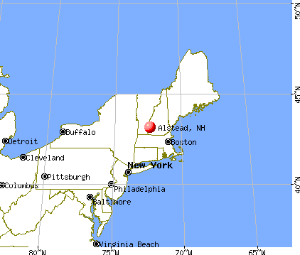
Nearest city with pop. 50,000+: Manchester, NH  (44.4 miles , pop. 107,006).
Nearest city with pop. 200,000+: Boston, MA (83.4 miles , pop. 589,141).
Nearest city with pop. 1,000,000+: Bronx, NY (177.0 miles , pop. 1,332,650).
Nearest cities:
), ), )Latitude: 43.13 N, Longitude: 72.31 W
Area code: 603

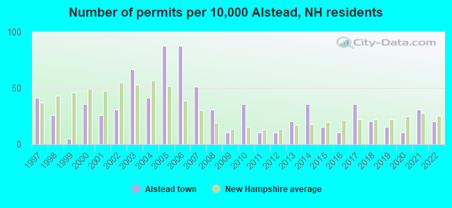
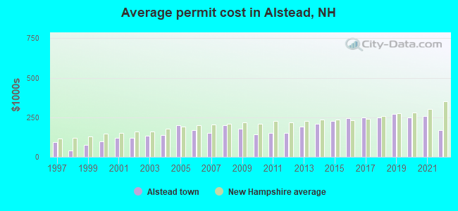
Single-family new house construction building permits:
- 2022: 4 buildings, average cost: $167,500
- 2021: 6 buildings, average cost: $259,200
- 2020: 2 buildings, average cost: $248,200
- 2019: 3 buildings, average cost: $271,400
- 2018: 4 buildings, average cost: $249,800
- 2017: 7 buildings, average cost: $247,800
- 2016: 2 buildings, average cost: $246,000
- 2015: 3 buildings, average cost: $226,800
- 2014: 7 buildings, average cost: $211,200
- 2013: 4 buildings, average cost: $193,300
- 2012: 2 buildings, average cost: $150,000
- 2011: 2 buildings, average cost: $150,000
- 2010: 7 buildings, average cost: $142,900
- 2009: 2 buildings, average cost: $178,900
- 2008: 6 buildings, average cost: $200,000
- 2007: 10 buildings, average cost: $150,000
- 2006: 17 buildings, average cost: $171,000
- 2005: 17 buildings, average cost: $200,000
- 2004: 8 buildings, average cost: $138,800
- 2003: 13 buildings, average cost: $132,800
- 2002: 6 buildings, average cost: $121,400
- 2001: 5 buildings, average cost: $121,400
- 2000: 7 buildings, average cost: $100,000
- 1999: 1 building, cost: $75,000
- 1998: 5 buildings, average cost: $39,000
- 1997: 8 buildings, average cost: $91,700
| Here: | 2.7% |
| New Hampshire: | 2.5% |
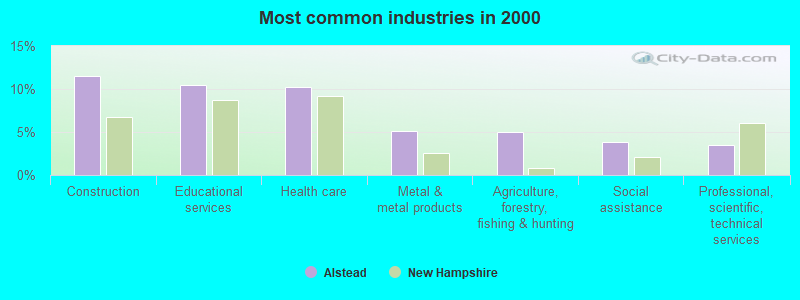
- Construction (11.5%)
- Educational services (10.5%)
- Health care (10.2%)
- Metal & metal products (5.1%)
- Agriculture, forestry, fishing & hunting (5.0%)
- Social assistance (3.8%)
- Professional, scientific, technical services (3.5%)
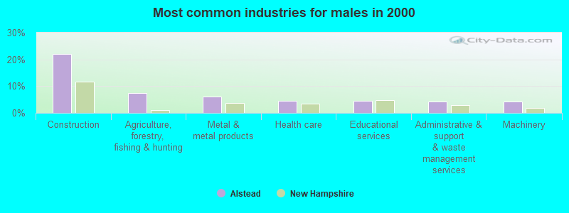
- Construction (22.1%)
- Agriculture, forestry, fishing & hunting (7.4%)
- Metal & metal products (6.1%)
- Health care (4.4%)
- Educational services (4.4%)
- Administrative & support & waste management services (4.2%)
- Machinery (4.2%)
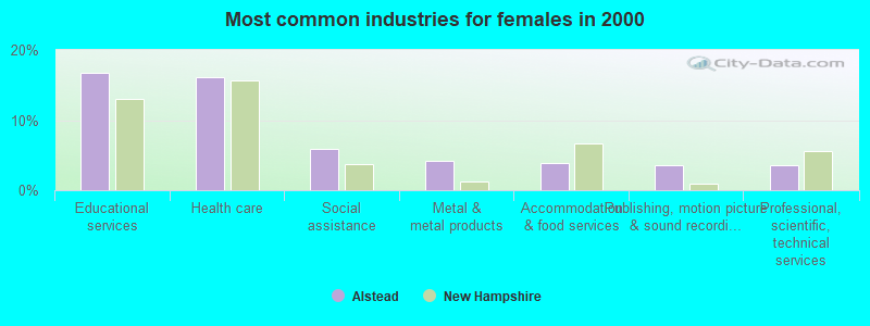
- Educational services (16.8%)
- Health care (16.2%)
- Social assistance (5.9%)
- Metal & metal products (4.2%)
- Accommodation & food services (3.8%)
- Publishing, motion picture & sound recording industries (3.6%)
- Professional, scientific, technical services (3.6%)
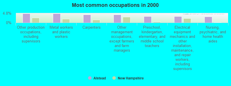
- Other production occupations, including supervisors (4.6%)
- Metal workers and plastic workers (4.6%)
- Carpenters (4.1%)
- Other management occupations, except farmers and farm managers (4.1%)
- Preschool, kindergarten, elementary, and middle school teachers (3.2%)
- Electrical equipment mechanics and other installation, maintenance, and repair workers, including supervisors (3.2%)
- Nursing, psychiatric, and home health aides (3.0%)
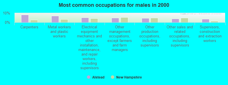
- Carpenters (8.1%)
- Metal workers and plastic workers (7.0%)
- Electrical equipment mechanics and other installation, maintenance, and repair workers, including supervisors (5.2%)
- Other management occupations, except farmers and farm managers (5.0%)
- Other production occupations, including supervisors (4.6%)
- Other sales and related occupations, including supervisors (3.9%)
- Supervisors, construction and extraction workers (3.7%)
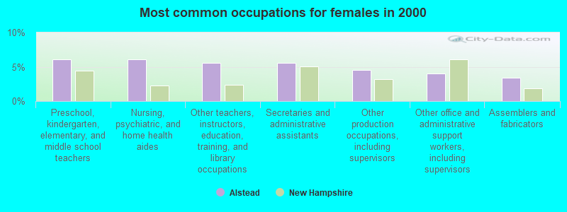
- Preschool, kindergarten, elementary, and middle school teachers (6.1%)
- Nursing, psychiatric, and home health aides (6.1%)
- Other teachers, instructors, education, training, and library occupations (5.5%)
- Secretaries and administrative assistants (5.5%)
- Other production occupations, including supervisors (4.6%)
- Other office and administrative support workers, including supervisors (4.0%)
- Assemblers and fabricators (3.4%)
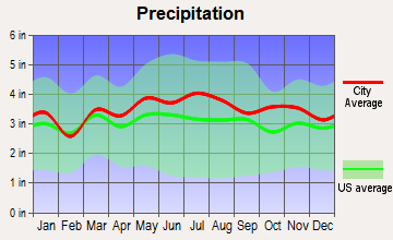
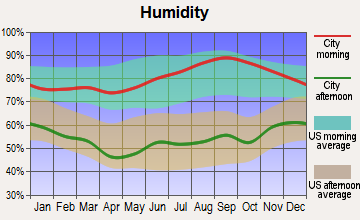
Average climate in Alstead, New Hampshire
Based on data reported by over 4,000 weather stations

(lower is better)
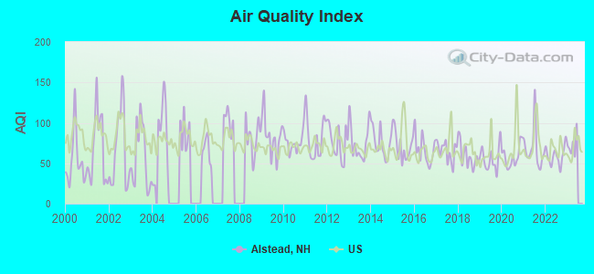
Air Quality Index (AQI) level in 2022 was 59.0. This is better than average.
| City: | 59.0 |
| U.S.: | 72.6 |
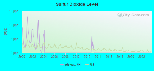
Sulfur Dioxide (SO2) [ppb] level in 2003 was 3.66. This is significantly worse than average. Closest monitor was 13.3 miles away from the city center.
| City: | 3.66 |
| U.S.: | 1.51 |
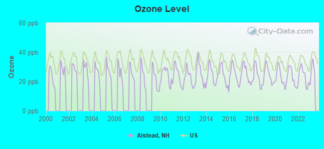
Ozone [ppb] level in 2022 was 23.7. This is significantly better than average. Closest monitor was 13.3 miles away from the city center.
| City: | 23.7 |
| U.S.: | 33.3 |
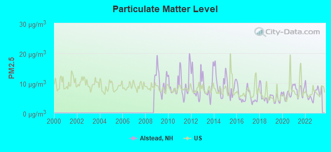
Particulate Matter (PM2.5) [µg/m3] level in 2022 was 5.97. This is better than average. Closest monitor was 13.7 miles away from the city center.
| City: | 5.97 |
| U.S.: | 8.11 |
Tornado activity:
Alstead-area historical tornado activity is slightly above New Hampshire state average. It is 37% smaller than the overall U.S. average.
On 8/20/1968, a category F3 (max. wind speeds 158-206 mph) tornado 24.9 miles away from the Alstead town center injured one person and caused between $5000 and $50,000 in damages.
On 6/9/1953, a category F4 (max. wind speeds 207-260 mph) tornado 46.0 miles away from the town center killed 90 people and injured 1228 people and caused between $50,000,000 and $500,000,000 in damages.
Earthquake activity:
Alstead-area historical earthquake activity is significantly above New Hampshire state average. It is 70% smaller than the overall U.S. average.On 10/7/1983 at 10:18:46, a magnitude 5.3 (5.1 MB, 5.3 LG, 5.1 ML, Class: Moderate, Intensity: VI - VII) earthquake occurred 116.8 miles away from the city center
On 4/20/2002 at 10:50:47, a magnitude 5.3 (5.3 ML, Depth: 3.0 mi) earthquake occurred 118.2 miles away from Alstead center
On 4/20/2002 at 10:50:47, a magnitude 5.2 (5.2 MB, 4.2 MS, 5.2 MW, 5.0 MW) earthquake occurred 117.4 miles away from the city center
On 1/19/1982 at 00:14:42, a magnitude 4.7 (4.5 MB, 4.7 MD, 4.5 LG, Class: Light, Intensity: IV - V) earthquake occurred 44.0 miles away from the city center
On 10/16/2012 at 23:12:25, a magnitude 4.7 (4.7 ML, Depth: 10.0 mi) earthquake occurred 89.3 miles away from Alstead center
On 6/17/1991 at 08:53:16, a magnitude 4.1 (4.0 MB, 4.0 LG, Depth: 3.1 mi) earthquake occurred 124.9 miles away from the city center
Magnitude types: regional Lg-wave magnitude (LG), body-wave magnitude (MB), duration magnitude (MD), local magnitude (ML), surface-wave magnitude (MS), moment magnitude (MW)
Natural disasters:
The number of natural disasters in Cheshire County (27) is a lot greater than the US average (15).Major Disasters (Presidential) Declared: 16
Emergencies Declared: 11
Causes of natural disasters: Floods: 11, Storms: 11, Snows: 4, Snowstorms: 3, Winter Storms: 3, Hurricanes: 2, Blizzard: 1, Heavy Rain: 1, Ice Storm: 1, Landslide: 1, Snowfall: 1, Tropical Storm: 1, Wind: 1, Other: 1 (Note: some incidents may be assigned to more than one category).
Hospitals and medical centers near Alstead:
- MCGIRR NURSING HOME (Nursing Home, about 8 miles away; BELLOWS FALLS, VT)
- KEENE CENTER, GENESIS HEALTHCARE (Nursing Home, about 12 miles away; KEENE, NH)
- CEDARCREST INC (Hospital, about 13 miles away; KEENE, NH)
- CHESHIRE MEDICAL CENTER Acute Care Hospitals (about 13 miles away; KEENE, NH)
- SNF CHESHIRE MEDICAL CTR. (Nursing Home, about 13 miles away; KEENE, NH)
- CHESHIRE COUNTY HOME (Nursing Home, about 14 miles away; WESTMORELAND, NH)
- HOSPICE OF THE MONADNOCK REGION (Hospital, about 14 miles away; KEENE, NH)
Amtrak stations near Alstead:
Colleges/universities with over 2000 students nearest to Alstead:
- Keene State College (about 14 miles; Keene, NH; Full-time enrollment: 5,098)
- Franklin Pierce University (about 28 miles; Rindge, NH; FT enrollment: 2,139)
- NHTI-Concord's Community College (about 40 miles; Concord, NH; FT enrollment: 2,865)
- Dartmouth College (about 40 miles; Hanover, NH; FT enrollment: 6,030)
- Mount Wachusett Community College (about 41 miles; Gardner, MA; FT enrollment: 3,143)
- Saint Anselm College (about 42 miles; Manchester, NH; FT enrollment: 2,059)
- Southern New Hampshire University (about 44 miles; Manchester, NH; FT enrollment: 16,552)
Public elementary/middle schools in Alstead:
- VILAS ELEMENTARY SCHOOL (Students: 124, Location: 82 MECHANIC ST., Grades: 5-8)
- ALSTEAD PRIMARY SCHOOL (Students: 117, Location: 58 MECHANIC ST., Grades: PK-4)
Points of interest:
Notable locations in Alstead: Alstead Fire Department East Station (A), Shedd-Porter Memorial Library (B), Alstead Fire Department Village Station (C). Display/hide their locations on the map
Churches in Alstead include: East Alstead Second Congregational Church (A), Alstead Center Congregational Church (B), Alstead Village Third Congregational Church (C), Church of the Good Shepherd Universalist Society (D). Display/hide their locations on the map
Cemeteries: Center Cemetery (1), Slade Cemetery (2). Display/hide their locations on the map
Lakes and reservoirs: Caldwell Pond (A), Converse Pond (B), Crane Pond (C), Kidders Pond (D), Lily Pond (E), Raymond Pond (F), Wellman Pond (G), Arch Pond (H). Display/hide their locations on the map
Streams, rivers, and creeks: Warren Brook (A), Hale Brook (B), Camp Brook (C). Display/hide their locations on the map
Birthplace of: John G. Shedd - Businessman.
| This town: | 2.4 people |
| New Hampshire: | 2.5 people |
| This town: | 65.4% |
| Whole state: | 66.3% |
| This town: | 10.5% |
| Whole state: | 8.3% |
Likely homosexual households (counted as self-reported same-sex unmarried-partner households)
- Lesbian couples: 0.6% of all households
- Gay men: 0.7% of all households
| This town: | 7.9% |
| Whole state: | 6.5% |
| This town: | 2.0% |
| Whole state: | 2.8% |
For population 15 years and over in Alstead:
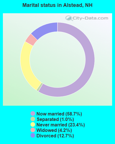
- Never married: 23.4%
- Now married: 58.7%
- Separated: 1.0%
- Widowed: 4.2%
- Divorced: 12.7%
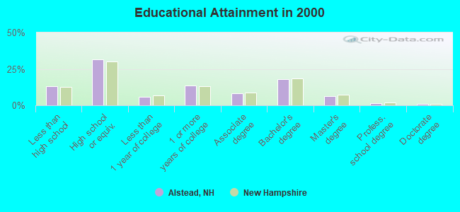
For population 25 years and over in Alstead:
- High school or higher: 86.7%
- Bachelor's degree or higher: 27.4%
- Graduate or professional degree: 9.2%
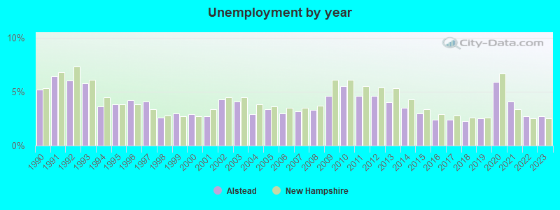
- Unemployed: 4.4%
- Mean travel time to work (commute): 28.6 minutes
| Here: | 10.6 |
| New Hampshire average: | 10.9 |
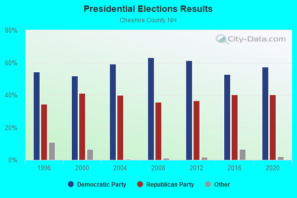
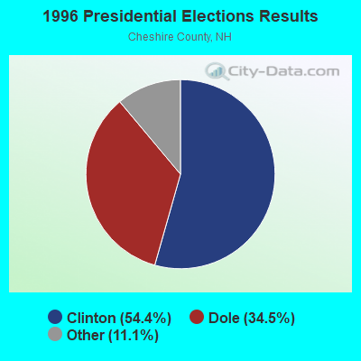
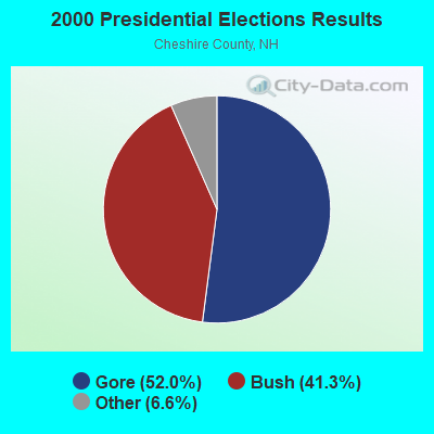
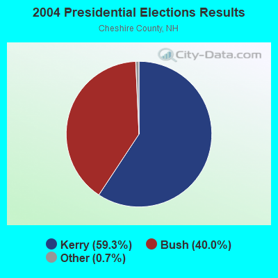

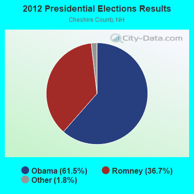
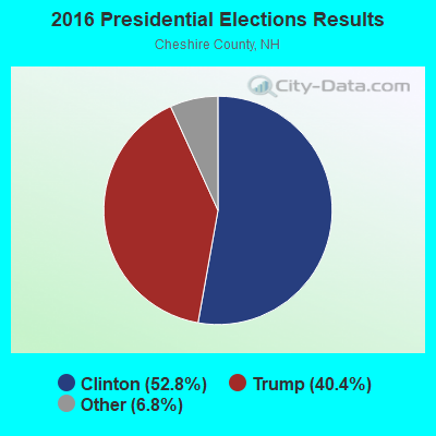
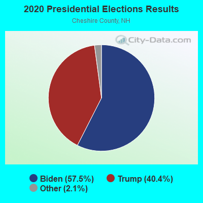
Graphs represent county-level data. Detailed 2008 Election Results
Religion statistics for Alstead, NH (based on Cheshire County data)
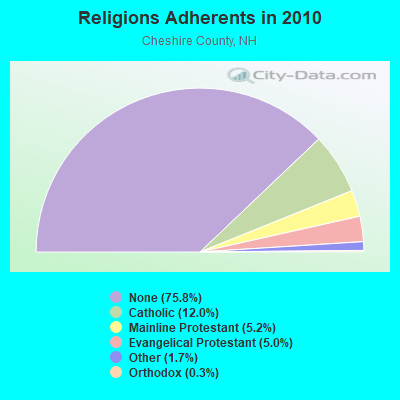
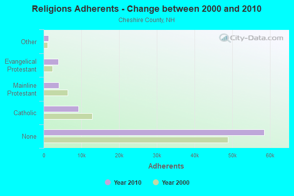
| Religion | Adherents | Congregations |
|---|---|---|
| Catholic | 9,237 | 9 |
| Mainline Protestant | 4,015 | 37 |
| Evangelical Protestant | 3,881 | 25 |
| Other | 1,292 | 13 |
| Orthodox | 250 | 1 |
| None | 58,442 | - |
Food Environment Statistics:
| Cheshire County: | 3.10 / 10,000 pop. |
| New Hampshire: | 2.14 / 10,000 pop. |
| Cheshire County: | 3.10 / 10,000 pop. |
| New Hampshire: | 1.78 / 10,000 pop. |
| Cheshire County: | 3.75 / 10,000 pop. |
| State: | 4.02 / 10,000 pop. |
| Here: | 8.67 / 10,000 pop. |
| State: | 9.70 / 10,000 pop. |
| This county: | 8.2% |
| New Hampshire: | 7.6% |
| Cheshire County: | 27.5% |
| New Hampshire: | 24.4% |
| This county: | 14.5% |
| State: | 15.9% |
Strongest AM radio stations in Alstead:
- WNTK (1020 AM; 10 kW; NEWPORT, NH; Owner: KOOR COMMUNICATIONS, INC.)
- WKBK (1290 AM; 5 kW; KEENE, NH; Owner: SAGA COMMUNICATIONS OF NEW ENGLAND, LLC)
- WNBX (1480 AM; 5 kW; SPRINGFIELD, VT)
- WNNZ (640 AM; 50 kW; WESTFIELD, MA; Owner: CLEAR CHANNEL BROADCASTING LICENSES, INC.)
- WCRN (830 AM; 50 kW; WORCESTER, MA; Owner: CARTER BROADCASTING CORPORATION)
- WRKO (680 AM; 50 kW; BOSTON, MA; Owner: ENTERCOM BOSTON LICENSE, LLC)
- WEEI (850 AM; 50 kW; BOSTON, MA; Owner: ENTERCOM BOSTON LICENSE, LLC)
- WVNE (760 AM; daytime; 25 kW; LEICESTER, MA; Owner: BLOUNT MASSCOM, INC.)
- WKOX (1200 AM; 50 kW; FRAMINGHAM, MA; Owner: CAPSTAR TX LIMITED PARTNERSHIP)
- WGY (810 AM; 50 kW; SCHENECTADY, NY; Owner: CLEAR CHANNEL BROADCASTING LICENSES, INC.)
- WBIX (1060 AM; 40 kW; NATICK, MA; Owner: LANGER BROADCASTING CORPORATION)
- WALE (990 AM; 50 kW; GREENVILLE, RI; Owner: NORTH AMERICAN BROADCASTING CO., INC.)
- WWZN (1510 AM; 50 kW; BOSTON, MA; Owner: ROSE CITY RADIO CORPORATION)
Strongest FM radio stations in Alstead:
- WKNE (103.7 FM; KEENE, NH; Owner: SAGA COMMUNICATIONS OF NEW ENGLAND, LLC)
- WEVN (90.7 FM; KEENE, NH; Owner: NEW HAMPSHIRE PUBLIC RADIO, INC.)
- WZSH (107.1 FM; BELLOWS FALLS, VT; Owner: GREAT NORTHERN RADIO, L.L.C.)
- WHDQ (106.1 FM; CLAREMONT, NH; Owner: GREAT NORTHERN RADIO, L.L.C.)
- WVPR (89.5 FM; WINDSOR, VT; Owner: VERMONT PUBLIC RADIO)
- WVRR (101.7 FM; NEWPORT, NH; Owner: CAPSTAR TX LIMITED PARTNERSHIP)
- WJJR (98.1 FM; RUTLAND, VT; Owner: 6 JOHNSON ROAD LICENSES, INC.)
- WZRT (97.1 FM; RUTLAND, VT; Owner: CAPSTAR TX LIMITED PARTNERSHIP)
- WCFR-FM (96.3 FM; WALPOLE, NH; Owner: GREAT NORTHERN RADIO, LLC)
- WEQX (102.7 FM; MANCHESTER, VT; Owner: NORTHSHIRE COMMUNICATIONS, INC.)
- WJAN (95.1 FM; SUNDERLAND, VT; Owner: 6 JOHNSON ROAD LICENSES, INC.)
- WEBK (105.3 FM; KILLINGTON, VT; Owner: 6 JOHNSON ROAD LICENSES, INC.)
- WFEX (92.1 FM; PETERBOROUGH, NH; Owner: FNX BROADCASTING OF NEW HAMPSHIRE LLC)
- WCMK (91.9 FM; PUTNEY, VT; Owner: CHRISTIAN MINISTRIES INC)
- W293AB (106.5 FM; KEENE, NH; Owner: GREAT NORTHERN RADIO, L.L.C.)
- WTPL (107.7 FM; HILLSBORO, NH; Owner: CONCORD BROADCASTING, L.L.C.)
- WGLV (91.7 FM; WOODSTOCK, VT; Owner: CHRISTIAN MINISTRIES INC)
- WHDQ-FM1 (106.1 FM; RUTLAND, VT; Owner: GREAT NORTHERN RADIO, L.L.C.)
- WVAY (100.7 FM; WILMINGTON, VT; Owner: GREAT NORTHERN RADIO, L.L.C.)
- WXKK (93.5 FM; SPRINGFIELD, VT; Owner: CLEAR CHANNEL BROADCASTING LICENSES, INC.)
TV broadcast stations around Alstead:
- WEKW-TV (Channel 52; KEENE, NH; Owner: UNIVERSITY OF NEW HAMPSHIRE)
- WVTA (Channel 41; WINDSOR, VT; Owner: VERMONT ETV, INC.)
Alstead fatal accident list:
Oct 1, 2013 02:40 AM, Gilsum Mine Road, Lat: 43.147956, Lon: -72.366958, Vehicles: 1, Persons: 2, Fatalities: 1, Drunk persons involved: 1
Apr 25, 2009 02:51 AM, Sr-123, Hemlock Ledge Lane, Lat: 43.131017, Lon: -72.311186, Vehicles: 1, Persons: 1, Fatalities: 1, Drunk persons involved: 1
Apr 23, 2005 10:32 PM, Thayer Brook Rd, Rhoades Rd, Lat: 43.165410, Lon: -72.269130, Vehicles: 1, Persons: 2, Fatalities: 1, Drunk persons involved: 1
Jun 21, 1992 08:00 PM, 4010094, Vehicles: 1, Persons: 1, Fatalities: 1
Mar 31, 1990 12:35 AM, Sr12a, Vehicles: 1, Persons: 4, Fatalities: 1
Oct 1, 1987 03:50 PM, 4016100000, Vehicles: 1, Persons: 1, Fatalities: 1
- National Bridge Inventory (NBI) Statistics
- 7Number of bridges
- 33ft / 10.3mTotal length
- $21,994,000Total costs
- 5,748Total average daily traffic
- 307Total average daily truck traffic
- 8,504Total future (year 2042) average daily traffic
FCC Registered Antenna Towers:
5- Mark L Gartley, Cobb Hill Road (Lat: 43.159806 Lon: -72.319417), Type: 76.2, Overall height: 74.6 m, Registrant: Holland & Knight LLP, Pconnolly@hklaw.Com, , Washi-ngton, Phone: (202) 862-5989
- Erik Brooks, Cobb Hill Road (Lat: 43.159806 Lon: -72.319417), Type: 76.2, Overall height: 74.6 m, Registrant: Holland & Knight LLP, Pconnolly@hklaw.Com, , Washi-ngton, Phone: (202) 862-5989
- Erik Brooks, Cobb Hill Road (Lat: 43.159806 Lon: -72.319417), Type: 60.6, Overall height: 58.8 m, Registrant: Holland & Knight LLP, Pconnolly@hklaw.Com, , Washi-ngton, Phone: (202) 862-5989
- Erik Brooks, Cobb Hill Road (Lat: 43.159806 Lon: -72.319417), Type: 60.6, Overall height: 58.8 m, Registrant: United States Cellular Corporation, Renee.Mazur@uscellular.Com, , Chica-go, Phone: (773) 399-8900
- Cayla Gamble, Cobb Hill Road (Lat: 43.159806 Lon: -72.319417), Type: 60.6, Structure height: 33005 m, Overall height: 58.8 m, Registrant: Wilkinson Barker Knauer, LLP, Gwerner@wbklaw.Com, , Washi-ngton, Phone: (202) 383-3420
FCC Registered Broadcast Land Mobile Towers:
4- Fire Station (Lat: 43.143139 Lon: -72.359806), Type: Bant, Structure height: 6 m, Overall height: 9 m, Call Sign: KDS606,
Assigned Frequencies: 154.430 MHz, Grant Date: 07/27/2021, Expiration Date: 08/25/2031, Registrant: Swnh Dist. Fire Mutual Aid, 32 Vernon Street, Keene, NH 03431, Phone: (603) 352-8635, Fax: (603) 357-1985, Email:
- Fire Station East Alstead (Lat: 43.127583 Lon: -72.279528), Type: Bant, Structure height: 6 m, Overall height: 8 m, Call Sign: KEP560,
Assigned Frequencies: 154.430 MHz, Grant Date: 07/27/2021, Expiration Date: 08/25/2031, Registrant: Swnh Dist. Fire Mutual Aid, 32 Vernon Street, Keene, NH 03431, Phone: (603) 352-8635, Fax: (603) 357-1985, Email:
- Police Dept (Lat: 43.143139 Lon: -72.359806), Structure height: 6 m, Call Sign: WPAE796,
Assigned Frequencies: 155.070 MHz, Grant Date: 07/12/2022, Expiration Date: 07/30/2032, Registrant: Cheshire County So, 12 Court Street, Keene, NH 03431, Phone: (603) 352-4238, Fax: (603) 355-3020, Email:
- 1 Mile Off Rt 123a (Lat: 43.108972 Lon: -72.315083), Type: Ntower, Structure height: 24.6 m, Overall height: 28.3 m, Call Sign: WPXT483,
Assigned Frequencies: 154.385 MHz, 154.430 MHz, Grant Date: 06/06/2023, Expiration Date: 06/06/2033, Certifier: Paul A Szoc, Registrant: Swnh District Fire Mutual Aid, 32 Vernon Street, Keene, NH 03431, Phone: (603) 352-8635, Fax: (603) 357-1985, Email:
FCC Registered Microwave Towers:
3- NH ALS MOO, Lat: 43.134111 Lon: -72.256056, Type: Ltower, Structure height: 24 m, Overall height: 25 m, Call Sign: WQJH296,
Assigned Frequencies: 3650.00 MHz, Grant Date: 11/07/2018, Expiration Date: 10/17/2020, Cancellation Date: 12/19/2020, Certifier: Brian R Foucher, Registrant: Business Radio Licensing, 30251 Golden Lantern, Suite E # 501, Laguna Niguel, CA 92677, Phone: (949) 348-8510, Fax: (949) 348-8514, Email:
- NH ALS COB, Lat: 43.159389 Lon: -72.315278, Type: Ltower, Structure height: 24 m, Call Sign: WQJH296,
Assigned Frequencies: 3650.00 MHz, Grant Date: 11/07/2018, Expiration Date: 10/17/2020, Cancellation Date: 12/19/2020, Certifier: Brian R Foucher, Registrant: Business Radio Licensing, 30251 Golden Lantern, Suite E # 501, Laguna Niguel, CA 92677, Phone: (949) 348-8510, Fax: (949) 348-8514, Email:
- ALSTEAD, 835 Alstead Center (Lat: 43.094000 Lon: -72.316889), Type: Mtower, Structure height: 45.7 m, Call Sign: WRAK929,
Assigned Frequencies: 11385.0 MHz, 11425.0 MHz, Grant Date: 12/19/2017, Expiration Date: 12/19/2027, Certifier: Dave Cundiff, Registrant: At&t Services, Inc., 208 S Akard St, 20f, Dallas, TX 75202, Phone: (855) 699-7073, Fax: (214) 746-6410, Email:
FCC Registered Amateur Radio Licenses:
28 (See the full list of FCC Registered Amateur Radio Licenses in Alstead)FAA Registered Aircraft:
3- Aircraft: AERONCA 7DC (Category: Land, Seats: 2, Weight: Up to 12,499 Pounds, Speed: 90 mph), Engine: CONT MOTOR A&C65 SERIES (65 HP) (Reciprocating)
N-Number: 4316E, N4316E, N-4316E, Serial Number: 7DC-26, Year manufactured: 1948, Certificate Issue Date: 07/26/2018
Registrant (Individual): Roger W Landry, 90 Pleasant St, Alstead, NH 03602 - Aircraft: KOHLER JOSEPH T KOLB FIRESTAR II (Category: Land, Weight: Up to 12,499 Pounds), Engine: BOMBARDIER ROTAX (ALL) (Reciprocating)
N-Number: 503K, N503K, N-503K, Serial Number: F1177, Year manufactured: 1996, Airworthiness Date: 04/19/1996, Certificate Issue Date: 04/10/1996
Registrant (Individual): Joseph T Kohler, 473 Walpole Valley Rd, Alstead, NH 03602 - Aircraft: KOHLER JOSEPH T PIETENPOL AIRCAMPER (Category: Land, Seats: 2, Weight: Up to 12,499 Pounds), Engine: Reciprocating
N-Number: 899JK, N899JK, N-899JK, Serial Number: 11KRJ46091, Certificate Issue Date: 03/24/1988
Registrant (Individual): Joseph T Kohler, 473 Walpole Valley Rd, Alstead, NH 03602
2002 - 2018 National Fire Incident Reporting System (NFIRS) incidents
- Fire incident types reported to NFIRS in Alstead, NH
- 15960.9%Structure Fires
- 6926.4%Outside Fires
- 186.9%Mobile Property/Vehicle Fires
- 155.7%Other
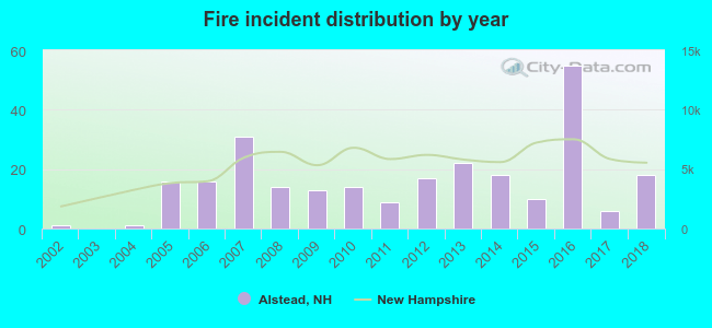 Based on the data from the years 2002 - 2018 the average number of fires per year is 15. The highest number of fire incidents - 55 took place in 2016, and the least - 0 in 2003. The data has a rising trend.
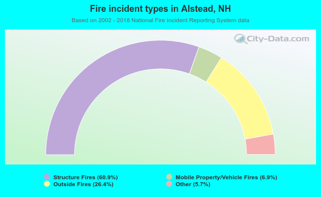 When looking into fire subcategories, the most incidents belonged to: Structure Fires (60.9%), and Outside Fires (26.4%).
- 60.3%Fuel oil, kerosene, etc.
- 28.5%Wood
- 6.8%Bottled, tank, or LP gas
- 2.1%Coal or coke
- 1.5%Electricity
- 0.8%No fuel used
- 53.0%Fuel oil, kerosene, etc.
- 19.5%Bottled, tank, or LP gas
- 15.2%Wood
- 11.0%Electricity
- 1.2%Utility gas
Alstead compared to New Hampshire state average:
- Median house value below state average.
- Unemployed percentage below state average.
- Black race population percentage significantly below state average.
- Hispanic race population percentage significantly below state average.
- Foreign-born population percentage significantly below state average.
- Length of stay since moving in significantly above state average.
- Number of rooms per house significantly below state average.
- House age significantly below state average.

|
|
Total of 7 patent applications in 2008-2024.