Ancram, New York
Submit your own pictures of this town and show them to the world
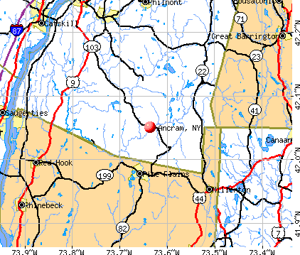
- OSM Map
- General Map
- Google Map
- MSN Map
Population change since 2000: +4.0%
 |
| Males: 809 | |
| Females: 764 |
| Median resident age: | 48.2 years |
| New York median age: | 40.7 years |
Zip codes: 12503.
| Ancram: | $87,169 |
| NY: | $79,557 |
Estimated per capita income in 2022: $49,963 (it was $22,541 in 2000)
Ancram town income, earnings, and wages data
Estimated median house or condo value in 2022: $305,314 (it was $114,800 in 2000)
| Ancram: | $305,314 |
| NY: | $400,400 |
Mean prices in 2022: all housing units: $422,433; detached houses: $455,747; townhouses or other attached units: $597,881; in 2-unit structures: $391,116; in 3-to-4-unit structures: $525,972; in 5-or-more-unit structures: over $1,000,000; mobile homes: $85,716
Detailed information about poverty and poor residents in Ancram, NY
Compare current foreclosures near Ancram, NY:
| Photo | Address | Area | Beds / Baths | Price | Details |
|---|---|---|---|---|---|

|
#1
County Route 7
Ancram, NY 12502
|
1,182 sq. feet
|
4 baths 7 beds |
show details | |

|
#2
State Route 22
Copake Falls, NY 12517
|
1,200 sq. feet
|
1 baths 2 beds |
$445,000
|
show details |

|
#3
Ferrara Dr
Rhinebeck, NY 12572
|
1,530 sq. feet
|
2 baths 3 beds |
show details | |

|
#4
Amenia Rd
Sharon, CT 06069
|
3,126 sq. feet
|
4 baths 4 beds |
show details | |

|
#5
Main St
Sheffield, MA 01257
|
3,683 sq. feet
|
5 baths 6 beds |
show details | |

|
#6
Hicks Ln
Clinton Corners, NY 12514
|
1,144 sq. feet
|
1 baths 3 beds |
show details | |

|
#7
Nevis Rd
Tivoli, NY 12583
|
2,256 sq. feet
|
2 baths 3 beds |
show details | |

|
#8
Nevis Rd
Tivoli, NY 12583
|
1,539 sq. feet
|
2 baths 3 beds |
show details | |

|
#9
Nine Partners Rd
Clinton Corners, NY 12514
|
2,158 sq. feet
|
3 baths 3 beds |
show details | |

|
#10
Eighmyville Rd
Rhinebeck, NY 12572
|
1,440 sq. feet
|
1 baths 3 beds |
show details |
| Photo | Address | Area | Beds / Baths | Price | Details |
|---|---|---|---|---|---|

|
#11
Alder St
Red Hook, NY 12571
|
1,027 sq. feet
|
1 baths 3 beds |
show details | |

|
#12
Route 22
Amenia, NY 12501
|
1,941 sq. feet
|
2 baths 3 beds |
show details | |

|
#13
County Rd
Great Barrington, MA 01230
|
1,576 sq. feet
|
1 baths 4 beds |
show details | |

|
#14
Amherst St
Red Hook, NY 12571
|
1,564 sq. feet
|
1 baths 3 beds |
show details | |

|
#15
Cambridge Dr
Red Hook, NY 12571
|
1,808 sq. feet
|
1 baths 3 beds |
show details | |

|
#16
County Route 21
Ghent, NY 12075
|
2,819 sq. feet
|
2 baths 6 beds |
show details | |

|
#17
N Shanks Rd
Clinton Corners, NY 12514
|
1,938 sq. feet
|
1 baths 3 beds |
show details | |

|
#18
White Birch Rd
Germantown, NY 12526
|
1,120 sq. feet
|
1 baths 4 beds |
show details | |

|
#19
Colonial Dr
Red Hook, NY 12571
|
2,464 sq. feet
|
2 baths 3 beds |
show details | |

|
#20
Shookville Rd
Red Hook, NY 12571
|
3,100 sq. feet
|
2 baths 3 beds |
show details |
| Photo | Address | Area | Beds / Baths | Price | Details |
|---|---|---|---|---|---|

|
#21
Route 44
Amenia, NY 12501
|
2,016 sq. feet
|
2 baths 3 beds |
show details | |

|
#22
Route 23
Hillsdale, NY 12529
|
2,762 sq. feet
|
2 baths 4 beds |
show details | |

|
#23
Sheldon Dr
Pine Plains, NY 12567
|
2,688 sq. feet
|
2 baths 3 beds |
show details | |

|
#24
Meusel Rd
Pine Plains, NY 12567
|
1,352 sq. feet
|
2 baths 3 beds |
show details | |

|
#25
Taft Rd
Copake, NY 12516
|
1,128 sq. feet
|
1 baths 2 beds |
show details | |

|
#26
Layton Rd
Stanfordville, NY 12581
|
1,660 sq. feet
|
1 baths 3 beds |
show details | |

|
#27
Myrtle Ave
Pine Plains, NY 12567
|
1,356 sq. feet
|
1 baths 3 beds |
show details | |

|
#28
S Undermountain Rd
Sheffield, MA 01257
|
1,713 sq. feet
|
2 baths 3 beds |
show details | |

|
#29
Route 82
Stanfordville, NY 12581
|
1,862 sq. feet
|
1 baths 3 beds |
show details | |

|
#30
Route 22
Amenia, NY 12501
|
- sq. feet
|
- baths - beds |
show details |
| Photo | Address | Area | Beds / Baths | Price | Details |
|---|---|---|---|---|---|

|
#31
Hull Rd
Elizaville, NY 12523
|
1,568 sq. feet
|
- baths - beds |
show details | |

|
#32
Main St
Millerton, NY 12546
|
- sq. feet
|
- baths - beds |
show details | |

|
#33
Kipp Rd
Hudson, NY 12534
|
- sq. feet
|
- baths - beds |
show details | |

|
#34
Ryan Rd
Pine Plains, NY 12567
|
- sq. feet
|
- baths - beds |
show details | |

|
#35
Viewmont Rd
Copake, NY 12516
|
- sq. feet
|
- baths - beds |
show details | |

|
#36
Route 9h
Hudson, NY 12534
|
- sq. feet
|
- baths - beds |
show details | |

|
#37
Amenia Union Rd # 2
Amenia, NY 12501
|
- sq. feet
|
- baths - beds |
show details | |

|
#38
Christian Hill Rd Apt 32
Great Barrington, MA 01230
|
- sq. feet
|
- baths - beds |
show details | |

|
#39
Church St
Pine Plains, NY 12567
|
- sq. feet
|
- baths - beds |
show details | |

|
#40
S Amenia Rd
Wassaic, NY 12592
|
- sq. feet
|
- baths - beds |
show details |
| Photo | Address | Area | Beds / Baths | Price | Details |
|---|---|---|---|---|---|

|
#41
Birch Hill Rd
Craryville, NY 12521
|
- sq. feet
|
- baths - beds |
show details | |

|
#42
Route 9h And 23
Hudson, NY 12534
|
- sq. feet
|
- baths - beds |
show details | |

|
#43
Blunt Rd
Great Barrington, MA 01230
|
- sq. feet
|
- baths - beds |
show details | |

|
#44
West Rd
Southfield, MA 01259
|
- sq. feet
|
- baths - beds |
show details | |

|
#45
County Route 19
Elizaville, NY 12523
|
- sq. feet
|
- baths - beds |
show details | |

|
#46
Route 22
Amenia, NY 12501
|
- sq. feet
|
- baths - beds |
show details | |

|
#47
N Shore Dr
Elizaville, NY 12523
|
- sq. feet
|
- baths - beds |
show details | |

|
#48
Root Ln
Sheffield, MA 01257
|
- sq. feet
|
- baths - beds |
show details | |

|
#49
Creamery Rd
Stanfordville, NY 12581
|
- sq. feet
|
- baths - beds |
show details | |

|
Check over 1 million property listings on Foreclosure.com!
|
browse all offers | |||

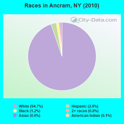
- 1,48994.7%White alone
- 412.6%Hispanic
- 191.2%Black alone
- 120.8%Two or more races
- 100.6%Asian alone
- 20.1%American Indian alone
Races in Ancram detailed stats: ancestries, foreign born residents, place of birth
According to our research of New York and other state lists, there were 2 registered sex offenders living in Ancram, New York as of May 21, 2024.
The ratio of all residents to sex offenders in Ancram is 787 to 1.
The ratio of registered sex offenders to all residents in this city is near the state average.
 Recent articles from our blog. Our writers, many of them Ph.D. graduates or candidates, create easy-to-read articles on a wide variety of topics.


 | Harlem Valley Rail Trail (2 replies) |
| Looking for Quaint Mountainy Town Semi-Close to NYC (47 replies) |
| Greenwood Lake, NY Anyone? (13 replies) |
| "Quaint" communities (43 replies) |
| Cold Spring or Millerton for second home in New York? (6 replies) |
| Normal nice towns in upstate NY? (8 replies) |
Latest news from Ancram, NY collected exclusively by city-data.com from local newspapers, TV, and radio stations
Ancestries: German (21.8%), Irish (18.3%), English (10.6%), United States (7.9%), Dutch (7.1%), Italian (6.6%).
Current Local Time: EST time zone
Land area: 42.6 square miles.
Population density: 37 people per square mile (very low).
63 residents are foreign born (3.0% Europe, 0.7% Asia).
| This town: | 4.2% |
| New York: | 20.4% |
| Ancram town: | 2.0% ($2,342) |
| New York: | 1.9% ($2,847) |
Nearest city with pop. 50,000+: Bristol, CT  (41.3 miles , pop. 60,062).
Nearest city with pop. 200,000+: Bronx, NY (83.7 miles , pop. 1,332,650).
Nearest cities:
), ), ), )Latitude: 42.04 N, Longitude: 73.58 W
Area code commonly used in this area: 518

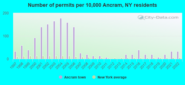
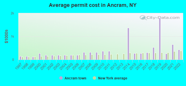
Single-family new house construction building permits:
- 2022: 5 buildings, average cost: $428,400
- 2021: 5 buildings, average cost: $653,200
- 2020: 3 buildings, average cost: $261,300
- 2019: 1 building, cost: $1,800,000
- 2018: 3 buildings, average cost: $533,300
- 2017: 3 buildings, average cost: $313,300
- 2016: 6 buildings, average cost: $273,500
- 2015: 3 buildings, average cost: $268,700
- 2014: 3 buildings, average cost: $1,375,000
- 2011: 1 building, cost: $375,000
- 2010: 2 buildings, average cost: $375,000
- 2009: 2 buildings, average cost: $325,000
- 2008: 3 buildings, average cost: $325,000
- 2007: 4 buildings, average cost: $325,000
- 2006: 21 buildings, average cost: $197,400
- 2005: 24 buildings, average cost: $197,400
- 2004: 27 buildings, average cost: $197,400
- 2003: 25 buildings, average cost: $197,400
- 2002: 23 buildings, average cost: $197,400
- 2001: 21 buildings, average cost: $197,400
- 2000: 14 buildings, average cost: $272,500
- 1999: 6 buildings, average cost: $126,500
- 1998: 9 buildings, average cost: $142,800
- 1997: 5 buildings, average cost: $149,400
| Here: | 3.2% |
| New York: | 4.4% |
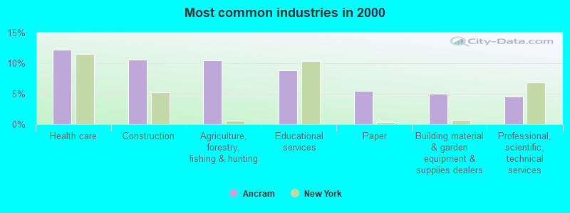
- Health care (12.2%)
- Construction (10.6%)
- Agriculture, forestry, fishing & hunting (10.4%)
- Educational services (8.9%)
- Paper (5.4%)
- Building material & garden equipment & supplies dealers (5.0%)
- Professional, scientific, technical services (4.5%)
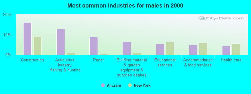
- Construction (16.1%)
- Agriculture, forestry, fishing & hunting (12.8%)
- Paper (8.9%)
- Building material & garden equipment & supplies dealers (6.5%)
- Educational services (5.4%)
- Accommodation & food services (4.9%)
- Health care (4.4%)
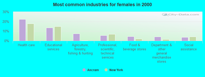
- Health care (22.3%)
- Educational services (13.4%)
- Agriculture, forestry, fishing & hunting (7.3%)
- Professional, scientific, technical services (5.5%)
- Food & beverage stores (4.6%)
- Department & other general merchandise stores (4.3%)
- Social assistance (3.7%)
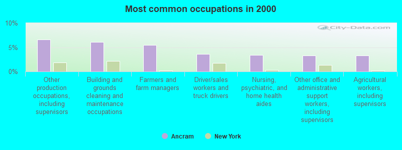
- Other production occupations, including supervisors (6.6%)
- Building and grounds cleaning and maintenance occupations (6.1%)
- Farmers and farm managers (5.4%)
- Driver/sales workers and truck drivers (3.6%)
- Nursing, psychiatric, and home health aides (3.4%)
- Other office and administrative support workers, including supervisors (3.3%)
- Agricultural workers, including supervisors (3.3%)
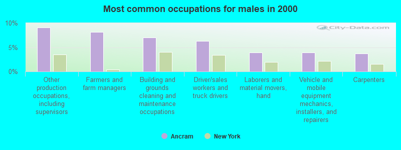
- Other production occupations, including supervisors (9.1%)
- Farmers and farm managers (8.2%)
- Building and grounds cleaning and maintenance occupations (7.0%)
- Driver/sales workers and truck drivers (6.3%)
- Laborers and material movers, hand (4.0%)
- Vehicle and mobile equipment mechanics, installers, and repairers (4.0%)
- Carpenters (3.7%)
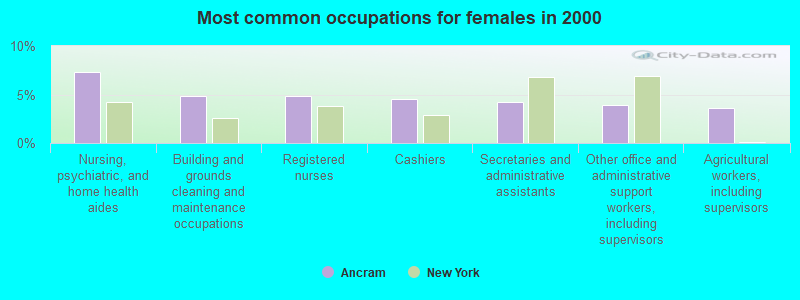
- Nursing, psychiatric, and home health aides (7.3%)
- Building and grounds cleaning and maintenance occupations (4.9%)
- Registered nurses (4.9%)
- Cashiers (4.6%)
- Secretaries and administrative assistants (4.3%)
- Other office and administrative support workers, including supervisors (4.0%)
- Agricultural workers, including supervisors (3.7%)
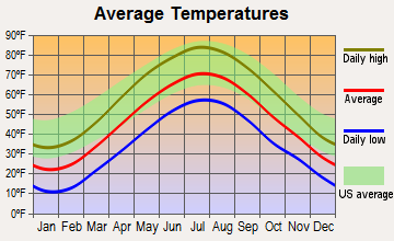
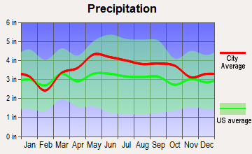
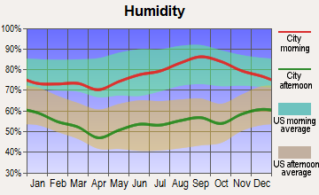
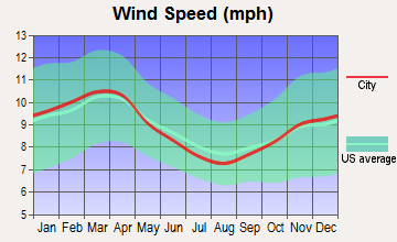
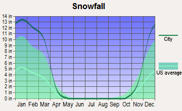
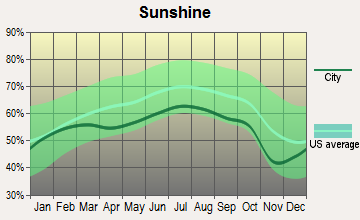
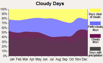
Average climate in Ancram, New York
Based on data reported by over 4,000 weather stations
(lower is better)
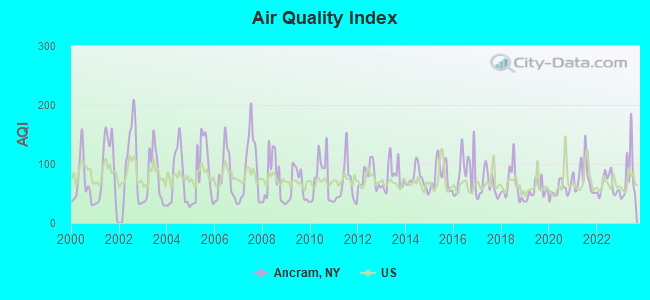
Air Quality Index (AQI) level in 2023 was 79.4. This is about average.
| City: | 79.4 |
| U.S.: | 72.6 |
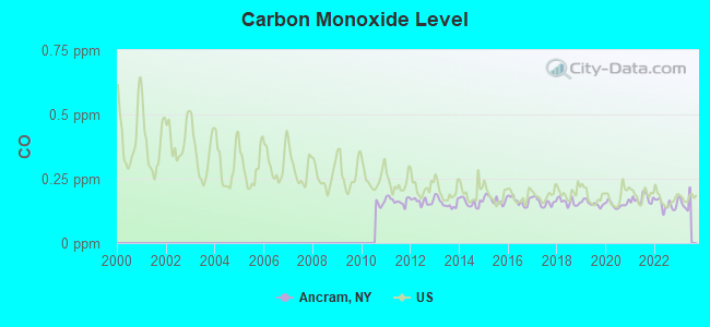
Carbon Monoxide (CO) [ppm] level in 2022 was 0.149. This is significantly better than average. Closest monitor was 5.4 miles away from the city center.
| City: | 0.149 |
| U.S.: | 0.251 |
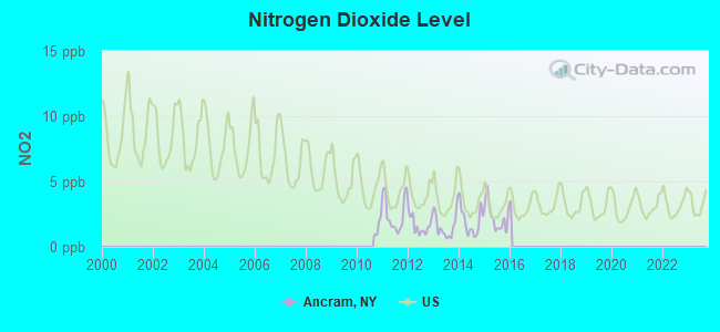
Nitrogen Dioxide (NO2) [ppb] level in 2015 was 2.27. This is significantly better than average. Closest monitor was 5.4 miles away from the city center.
| City: | 2.27 |
| U.S.: | 5.11 |
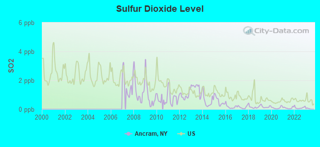
Sulfur Dioxide (SO2) [ppb] level in 2022 was 0.109. This is significantly better than average. Closest monitor was 5.4 miles away from the city center.
| City: | 0.109 |
| U.S.: | 1.515 |
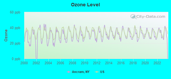
Ozone [ppb] level in 2023 was 33.0. This is about average. Closest monitor was 19.2 miles away from the city center.
| City: | 33.0 |
| U.S.: | 33.3 |
Particulate Matter (PM10) [µg/m3] level in 2022 was 9.49. This is significantly better than average. Closest monitor was 20.8 miles away from the city center.
| City: | 9.49 |
| U.S.: | 19.21 |
Particulate Matter (PM2.5) [µg/m3] level in 2022 was 4.86. This is significantly better than average. Closest monitor was 20.8 miles away from the city center.
| City: | 4.86 |
| U.S.: | 8.11 |
Tornado activity:
Ancram-area historical tornado activity is significantly above New York state average. It is 23% smaller than the overall U.S. average.
On 5/29/1995, a category F4 (max. wind speeds 207-260 mph) tornado 13.7 miles away from the Ancram town center killed 3 people and injured 24 people and caused between $5,000,000 and $50,000,000 in damages.
On 8/28/1973, a category F4 tornado 19.2 miles away from the town center killed 4 people and injured 36 people and caused between $5,000,000 and $50,000,000 in damages.
Earthquake activity:
Ancram-area historical earthquake activity is significantly above New York state average. It is 68% smaller than the overall U.S. average.On 10/7/1983 at 10:18:46, a magnitude 5.3 (5.1 MB, 5.3 LG, 5.1 ML, Class: Moderate, Intensity: VI - VII) earthquake occurred 138.1 miles away from the city center
On 4/20/2002 at 10:50:47, a magnitude 5.3 (5.3 ML, Depth: 3.0 mi) earthquake occurred 171.4 miles away from the city center
On 4/20/2002 at 10:50:47, a magnitude 5.2 (5.2 MB, 4.2 MS, 5.2 MW, 5.0 MW) earthquake occurred 169.7 miles away from the city center
On 1/19/1982 at 00:14:42, a magnitude 4.7 (4.5 MB, 4.7 MD, 4.5 LG, Class: Light, Intensity: IV - V) earthquake occurred 142.7 miles away from Ancram center
On 8/23/2011 at 17:51:04, a magnitude 5.8 (5.8 MW, Depth: 3.7 mi) earthquake occurred 367.0 miles away from Ancram center
On 10/16/2012 at 23:12:25, a magnitude 4.7 (4.7 ML, Depth: 10.0 mi) earthquake occurred 183.5 miles away from Ancram center
Magnitude types: regional Lg-wave magnitude (LG), body-wave magnitude (MB), duration magnitude (MD), local magnitude (ML), surface-wave magnitude (MS), moment magnitude (MW)
Natural disasters:
The number of natural disasters in Columbia County (22) is greater than the US average (15).Major Disasters (Presidential) Declared: 12
Emergencies Declared: 9
Causes of natural disasters: Storms: 7, Floods: 6, Hurricanes: 4, Winter Storms: 4, Snowstorms: 3, Blizzards: 2, Power Outage: 1, Tornado: 1, Other: 2 (Note: some incidents may be assigned to more than one category).
Hospitals and medical centers near Ancram:
- NOBLE HORIZONS (Nursing Home, about 9 miles away; SALISBURY, CT)
- SHARON HOSPITAL Acute Care Hospitals (about 12 miles away; SHARON, CT)
- SHARON HEALTH CARE CENTER (Nursing Home, about 12 miles away; SHARON, CT)
- GEER NURSING AND REHABILITATIO (Nursing Home, about 14 miles away; CANAAN, CT)
- LIVINGSTON HILLS NURSING AND REHAB CTR L L C (Nursing Home, about 14 miles away; LIVINGSTON, NY)
- KINDRED NRSING AND REHABILITATION-TIMBERLYN HEIGHTS (Nursing Home, about 15 miles away; GREAT BARRINGTON, MA)
- CARDINAL HAYES HOME FOR CHILDREN, INC (Hospital, about 15 miles away; RED HOOK, NY)
Amtrak station near Ancram:
Colleges/universities with over 2000 students nearest to Ancram:
- Bard College (about 17 miles; Annandale-On-Hudson, NY; Full-time enrollment: 3,137)
- Culinary Institute of America (about 28 miles; Hyde Park, NY; FT enrollment: 3,869)
- Dutchess Community College (about 28 miles; Poughkeepsie, NY; FT enrollment: 6,554)
- Marist College (about 29 miles; Poughkeepsie, NY; FT enrollment: 5,536)
- Vassar College (about 30 miles; Poughkeepsie, NY; FT enrollment: 2,469)
- Ulster County Community College (about 31 miles; Stone Ridge, NY; FT enrollment: 2,207)
- State University of New York at New Paltz (about 34 miles; New Paltz, NY; FT enrollment: 7,319)
Points of interest:
Notable locations in Ancram: Barton Corners (A), Millerhurst Farm (B), Undermountain Golf Course (C), Thompson-Finch Farm (D). Display/hide their locations on the map
Churches in Ancram include: Saint John's Lutheran Church (A), Ancramdale Presbyterian Church (B). Display/hide their locations on the map
Cemeteries: Ancram Old Cemetery (1), Ancram Union Cemetery (2). Display/hide their locations on the map
Lakes and swamps: Long Pond (A), Lower Rhoda Pond (B), Dewitt Pond (C), Drowned Lands Swamp (D). Display/hide their locations on the map
Streams, rivers, and creeks: Bash Bish Brook (A), Punch Brook (B). Display/hide their locations on the map
Park in Ancram: Taconic State Park (1). Display/hide its location on the map
Drinking water stations with addresses in Ancram and their reported violations in the past:
LAKE TAGHKANIC STATE PARK (Address: 1528 ROUTE 82 , Population served: 2,500, Surface water):Past monitoring violations:JO JOS (Address: 1015 ROUTE 82 , Population served: 25, Groundwater):
- 2 routine major monitoring violations
- 3 regular monitoring violations
Past monitoring violations:
- 10 routine major monitoring violations
- 2 regular monitoring violations
| This town: | 2.4 people |
| New York: | 2.6 people |
| This town: | 67.9% |
| Whole state: | 63.5% |
| This town: | 8.5% |
| Whole state: | 6.8% |
Likely homosexual households (counted as self-reported same-sex unmarried-partner households)
- Lesbian couples: 0.5% of all households
- Gay men: 1.2% of all households
| This town: | 7.4% |
| Whole state: | 14.6% |
| This town: | 3.1% |
| Whole state: | 7.4% |
For population 15 years and over in Ancram:
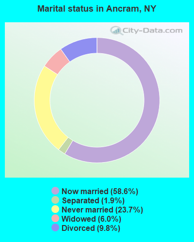
- Never married: 23.7%
- Now married: 58.6%
- Separated: 1.9%
- Widowed: 6.0%
- Divorced: 9.8%
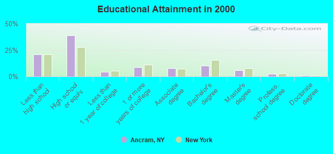
For population 25 years and over in Ancram:
- High school or higher: 79.3%
- Bachelor's degree or higher: 19.3%
- Graduate or professional degree: 9.1%
- Unemployed: 4.3%
- Mean travel time to work (commute): 27.5 minutes
| Here: | 13.0 |
| New York average: | 14.2 |
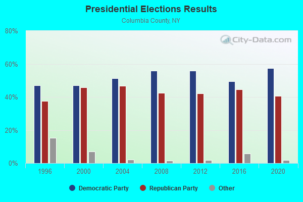
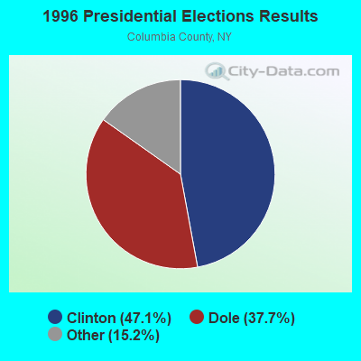
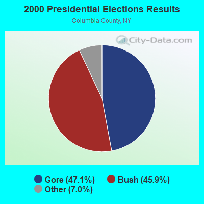
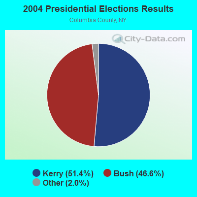
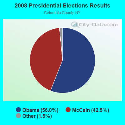

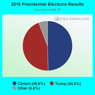
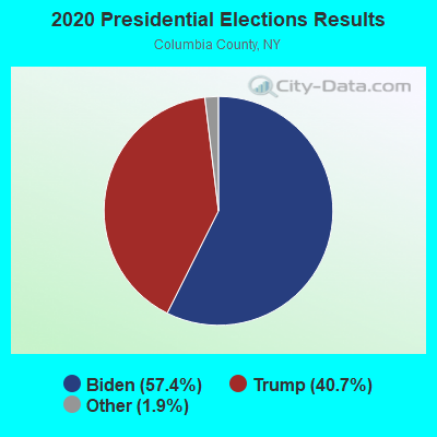
Graphs represent county-level data. Detailed 2008 Election Results
Religion statistics for Ancram, NY (based on Columbia County data)
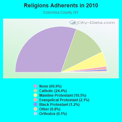
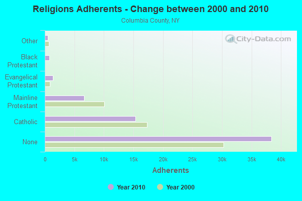
| Religion | Adherents | Congregations |
|---|---|---|
| Catholic | 15,375 | 11 |
| Mainline Protestant | 6,636 | 53 |
| Evangelical Protestant | 1,329 | 16 |
| Black Protestant | 776 | 3 |
| Other | 513 | 7 |
| Orthodox | 70 | 2 |
| None | 38,397 | - |
Food Environment Statistics:
| Columbia County: | 3.54 / 10,000 pop. |
| New York: | 4.13 / 10,000 pop. |
| Columbia County: | 0.80 / 10,000 pop. |
| New York: | 0.92 / 10,000 pop. |
| This county: | 4.98 / 10,000 pop. |
| New York: | 1.68 / 10,000 pop. |
| Here: | 11.09 / 10,000 pop. |
| New York: | 8.82 / 10,000 pop. |
| Here: | 8.6% |
| New York: | 8.2% |
| Columbia County: | 27.0% |
| New York: | 23.8% |
| Columbia County: | 17.1% |
| State: | 15.6% |
Strongest AM radio stations in Ancram:
- WKZE (1020 AM; daytime; 2 kW; SHARON, CT; Owner: JOHNSON DEVELOPMENT, INC.)
- WNNZ (640 AM; 50 kW; WESTFIELD, MA; Owner: CLEAR CHANNEL BROADCASTING LICENSES, INC.)
- WTIC (1080 AM; 50 kW; HARTFORD, CT; Owner: INFINITY RADIO OPERATIONS INC.)
- WGY (810 AM; 50 kW; SCHENECTADY, NY; Owner: CLEAR CHANNEL BROADCASTING LICENSES, INC.)
- WPTR (1540 AM; 50 kW; ALBANY, NY; Owner: KIMTRON, INC.)
- WFAN (660 AM; 50 kW; NEW YORK, NY; Owner: INFINITY BROADCASTING OPERATIONS, INC.)
- WGHQ (920 AM; 5 kW; KINGSTON, NY; Owner: CLEVELAND RADIO LICENSES, LLC)
- WSBS (860 AM; 3 kW; GREAT BARRINGTON, MA; Owner: BERKSHIRE BROADCASTING CO., INC.)
- WMCA (570 AM; 50 kW; NEW YORK, NY; Owner: SALEM MEDIA OF NEW YORK, LLC)
- WABC (770 AM; 50 kW; NEW YORK, NY; Owner: WABC-AM RADIO, INC.)
- WOR (710 AM; 50 kW; NEW YORK, NY; Owner: BUCKLEY BROADCASTING CORPORATION)
- WCBS (880 AM; 50 kW; NEW YORK, NY; Owner: INFINITY BROADCASTING OPERATIONS, INC.)
- WCRN (830 AM; 50 kW; WORCESTER, MA; Owner: CARTER BROADCASTING CORPORATION)
Strongest FM radio stations in Ancram:
- WAMQ (105.1 FM; GREAT BARRINGTON, MA; Owner: WAMC)
- WKZE-FM (98.1 FM; SALISBURY, CT; Owner: JOHNSON DEVELOPMENT, INC.)
- WHVP (91.1 FM; HUDSON, NY; Owner: SOUND OF LIFE, INC.)
- WAMK (90.9 FM; KINGSTON, NY; Owner: W A M C)
- WFGB (89.7 FM; KINGSTON, NY; Owner: SOUND OF LIFE, INC.)
- WQQQ (103.3 FM; SHARON, CT; Owner: THE RIDGEFIELD BROADCASTING CORPORATION)
- WPDH (101.5 FM; POUGHKEEPSIE, NY; Owner: CUMULUS LICENSING CORP.)
- WFNP (88.7 FM; ROSENDALE, NY; Owner: STATE UNIVERSITY OF NEW YORK)
- WRHV (88.7 FM; POUGHKEEPSIE, NY; Owner: WMHT EDUCATIONAL TELECOMMUNICATIONS)
- WRNQ (92.1 FM; POUGHKEEPSIE, NY; Owner: CLEAR CHANNEL BROADCASTING LICENSES, INC.)
- WAMC-FM (90.3 FM; ALBANY, NY; Owner: WAMC)
- W206AW (89.1 FM; PAWLING, NY; Owner: SOUND OF LIFE, INC.)
- WCZX (97.7 FM; HYDE PARK, NY; Owner: CUMULUS LICENSING CORP.)
- WRRB (96.9 FM; ARLINGTON, NY; Owner: CUMULUS LICENSING CORP.)
- WFKP (99.3 FM; ELLENVILLE, NY; Owner: CLEAR CHANNEL BROADCASTING LICENSES, INC.)
- WBWZ (93.3 FM; NEW PALTZ, NY; Owner: CLEVELAND RADIO LICENSES, LLC)
- WRWD-FM (107.3 FM; HIGHLAND, NY; Owner: CLEVELAND RADIO LICENSES, LLC)
- WCTW (98.5 FM; CATSKILL, NY; Owner: CLEAR CHANNEL BROADCASTING LICENSES, INC.)
- WSPK (104.7 FM; POUGHKEEPSIE, NY; Owner: 6 JOHNSON ROAD LICENSES, INC.)
- WBPM (94.3 FM; KINGSTON, NY; Owner: CONCORD MEDIA GROUP, INC.)
TV broadcast stations around Ancram:
- WTIC-TV (Channel 61; HARTFORD, CT; Owner: TRIBUNE TELEVISION COMPANY)
- W11BJ (Channel 11; HARTFORD, CT; Owner: COMMUNICATIONS SITE MANAGEMENT LLC)
- WTXX (Channel 20; WATERBURY, CT; Owner: WTXX INC.)
- WUVN (Channel 18; HARTFORD, CT; Owner: ENTRAVISION HOLDINGS, LLC)
- WVIT (Channel 30; NEW BRITAIN, CT; Owner: OUTLET BROADCASTING, INC)
- WEDH (Channel 24; HARTFORD, CT; Owner: CONNECTICUT PUBLIC BROADCASTING, INC.)
Ancram fatal accident list:
Jul 1, 2011 04:40 PM, Sr-82, Chase Rd, Lat: 41.978761, Lon: -73.614364, Vehicles: 1, Persons: 1, Fatalities: 1
Mar 23, 2006 06:45 AM, Cr-7, Sr-82, Lat: 42.047700, Lon: -73.640140, Vehicles: 1, Persons: 1, Fatalities: 1
May 15, 2004 05:00 AM, Sr-82, Chase Rd, Vehicles: 1, Persons: 2, Fatalities: 1, Drunk persons involved: 1
Aug 10, 2002 01:27 AM, Cr-7, Vehicles: 1, Persons: 1, Fatalities: 1, Drunk persons involved: 1
May 8, 1979 02:55 AM, Vehicles: 1, Persons: 1, Fatalities: 1, Drunk persons involved: 1
- National Bridge Inventory (NBI) Statistics
- 6Number of bridges
- 36ft / 10.8mTotal length
- $5,722,000Total costs
- 4,871Total average daily traffic
- 517Total average daily truck traffic
- 6,363Total future (year 2035) average daily traffic
FCC Registered Broadcast Land Mobile Towers:
5- Lake Taghkanic State Park Rt 82 & Taconic Pky 11 Mi Se Hudson (Lat: 42.091750 Lon: -73.704306), Type: Bant, Structure height: 10.3 m, Overall height: 21 m, Call Sign: KZO494, Licensee ID: L00002981,
Assigned Frequencies: 158.775 MHz, Grant Date: 11/06/2014, Expiration Date: 02/01/2025, Registrant: New York State Office Of Parks, Recreation, And Historic Preservation (Oprhp) - Taconic Region, 6105 E. Seneca Turnpike, Jamesville, NY 13078, Phone: (315) 498-9027, Fax: (315) 498-9219, Email:
- Rt 82 & Taconic Parkway Lake Tagh State Park 11 Mi Se Hudson (Lat: 42.091750 Lon: -73.704306), Type: Bant, Structure height: 15 m, Overall height: 21 m, Call Sign: WAN434,
Assigned Frequencies: 153.785 MHz, Grant Date: 03/17/2023, Expiration Date: 06/08/2033, Registrant: New York State Office Of Parks, Recreation & Historic Preservation (Op, 6105 E. Seneca Turnpike, Jamesville, NY 13078, Phone: (315) 498-9027, Fax: (315) 498-9219, Email:
- Lat: 42.050083 Lon: -73.632889, Call Sign: WPUD414, Licensee ID: L00312002,
Assigned Frequencies: 153.095 MHz, Grant Date: 02/02/2012, Expiration Date: 02/08/2022, Cancellation Date: 04/16/2022, Certifier: Larry A Heath, Registrant: Schweitzer Mauduit International, 2424 Rt 82, Ancram, NY 12502, Phone: (518) 329-5115, Fax: (518) 329-1161, Email:
- 525 Boston Corners Road (Lat: 42.049778 Lon: -73.513583), Type: Bant, Structure height: 6.1 m, Overall height: 13.4 m, Call Sign: WQFC821,
Assigned Frequencies: 158.385 MHz, Grant Date: 06/16/2006, Expiration Date: 06/16/2016, Cancellation Date: 08/20/2016, Certifier: Calvin Miller, Registrant: Washington Radio Reports, 1588 Fairfield Road Ste 7, Gettysburg, PA 17325, Phone: (717) 334-0668, Fax: (717) 334-6440, Email:
- Lat: 42.050139 Lon: -73.636750, Call Sign: WQVF437,
Assigned Frequencies: 154.355 MHz, Grant Date: 01/26/2015, Expiration Date: 01/26/2025, Certifier: David Boice, Registrant: Bearcom Wireless Worldwide, 221 North Greenbush Road, Troy, NY 12180, Phone: (518) 283-2735, Email:
FCC Registered Microwave Towers:
1- ANCRAM NY, 67 Wilmer Hill Road (Lat: 42.061111 Lon: -73.654500), Type: Mtower, Structure height: 45.7 m, Overall height: 47.6 m, Call Sign: WQYI986,
Assigned Frequencies: 11425.0 MHz, Grant Date: 10/13/2016, Expiration Date: 10/13/2026, Certifier: John E Monday, Registrant: At&t Services, Inc., 208 S Akard St, 20f, Dallas, TX 75202, Phone: (855) 699-7073, Fax: (214) 746-6410, Email:
FCC Registered Amateur Radio Licenses:
5- Call Sign: KW2D, Licensee ID: L00137074, Grant Date: 12/23/2006, Expiration Date: 01/31/2017, Cancellation Date: 07/01/2013, Registrant: Peter C Jaworski, 7 Elsohn Rd, Ancram, NY 12502
- Call Sign: WA2UYM, Licensee ID: L00147199, Grant Date: 10/10/2007, Expiration Date: 12/16/2017, Cancellation Date: 12/17/2019, Registrant: Regina A Jaworski, 7 Elshohn Rd, Ancram, NY 12502
- Call Sign: KD2GLP, Licensee ID: L01865300, Grant Date: 05/12/2014, Expiration Date: 05/12/2024, Certifier: Thomas R Dias, Registrant: Thomas R Dias, 114 Poole Hill Rd, Ancram, NY 12502
- Call Sign: KD2NBQ, Licensee ID: L02086268, Grant Date: 03/15/2017, Expiration Date: 03/15/2027, Cancellation Date: 04/04/2017, Certifier: Julian A Ferraro, Registrant: Julian A Ferraro, 1401 County Rt 7, Ancram, NY 12502
- Call Sign: KK7AYO, Previous Call Sign: KD2NBQ, Licensee ID: L02086268, Grant Date: 04/04/2017, Expiration Date: 04/04/2027, Certifier: Julian A Ferraro, Registrant: Julian A Ferraro, 1401 County Rt 7, Ancram, NY 12502
| Most common first names in Ancram, NY among deceased individuals | ||
| Name | Count | Lived (average) |
|---|---|---|
| William | 14 | 68.1 years |
| John | 10 | 78.3 years |
| Joseph | 8 | 76.1 years |
| George | 8 | 78.6 years |
| Anna | 7 | 90.8 years |
| Charles | 6 | 71.3 years |
| Frank | 5 | 74.8 years |
| Henry | 5 | 77.0 years |
| Donald | 5 | 76.0 years |
| Mary | 5 | 85.4 years |
| Most common last names in Ancram, NY among deceased individuals | ||
| Last name | Count | Lived (average) |
|---|---|---|
| Smith | 6 | 74.8 years |
| Hoyt | 5 | 77.8 years |
| Miller | 5 | 70.9 years |
| Roche | 4 | 71.8 years |
| Post | 4 | 87.5 years |
| Parsons | 4 | 76.0 years |
| Boice | 4 | 85.3 years |
| Tompkins | 4 | 71.0 years |
| Coons | 3 | 74.7 years |
| Mchugh | 3 | 83.0 years |
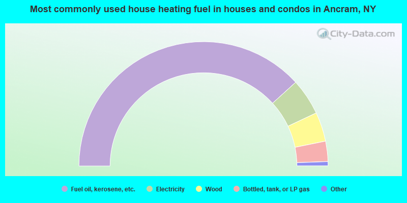
- 76.5%Fuel oil, kerosene, etc.
- 9.5%Electricity
- 7.6%Wood
- 5.3%Bottled, tank, or LP gas
- 0.6%Utility gas
- 0.4%Coal or coke
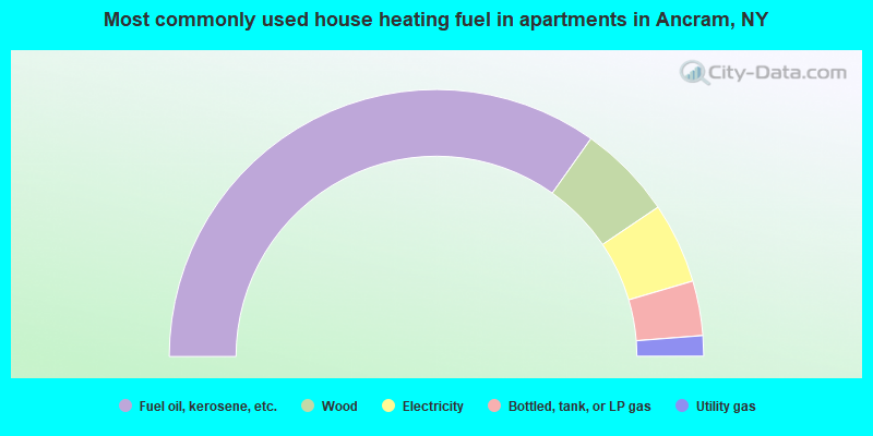
- 69.7%Fuel oil, kerosene, etc.
- 11.5%Wood
- 9.8%Electricity
- 6.6%Bottled, tank, or LP gas
- 2.5%Utility gas
Ancram compared to New York state average:
- Unemployed percentage significantly below state average.
- Black race population percentage significantly below state average.
- Hispanic race population percentage significantly below state average.
- Median age above state average.
- Foreign-born population percentage significantly below state average.
- Renting percentage significantly below state average.
- Length of stay since moving in significantly above state average.
- Number of rooms per house significantly below state average.
- House age significantly below state average.
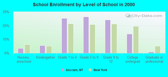
- Number of college students below state average.