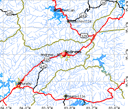
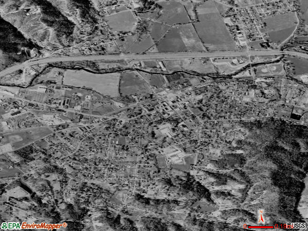
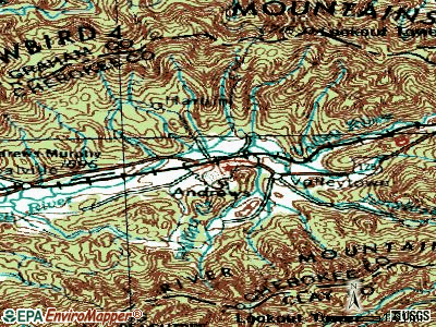
Andrews, North Carolina
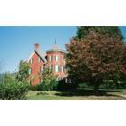
Andrews: private residence in Andrews, N.C.
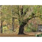
Andrews: Autumn in Andrews
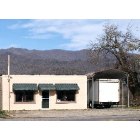
Andrews: Andrews Community Radio Station in Andrews, NC w/mountains in background

Andrews: Sunset Andrews NC
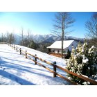
Andrews: Mountain Home just out side Andrews, NC
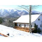
Andrews: Mountain Home in Andrews,NC
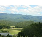
Andrews: A scenic valley in Andrews, NC
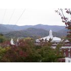
Andrews: Overlooking Downtown Andrews NC
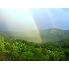
Andrews: Double Rain Bow over Andrews, NC
- add
your
Submit your own pictures of this town and show them to the world
- OSM Map
- General Map
- Google Map
- MSN Map
Population change since 2000: +5.5%
 |
| Males: 761 | |
| Females: 929 |
| Median resident age: | 46.1 years |
| North Carolina median age: | 39.2 years |
Zip codes: 28901.
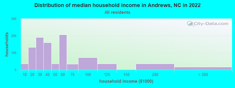
| Andrews: | $35,623 |
| NC: | $67,481 |
Estimated per capita income in 2022: $24,011 (it was $11,350 in 2000)
Andrews town income, earnings, and wages data
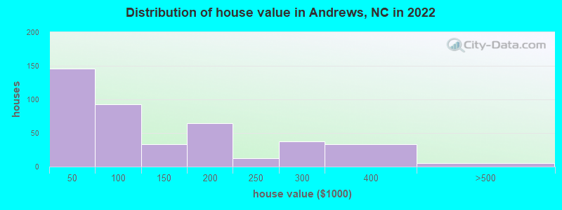
Estimated median house or condo value in 2022: $115,274 (it was $47,200 in 2000)
| Andrews: | $115,274 |
| NC: | $280,600 |
Mean prices in 2022: all housing units: $130,655; detached houses: $200,310; mobile homes: $58,437
Median gross rent in 2022: $769.
(23.9% for White Non-Hispanic residents, 55.6% for Black residents, 32.9% for Hispanic or Latino residents, 40.5% for American Indian residents, 33.7% for other race residents, 1.3% for two or more races residents)
Detailed information about poverty and poor residents in Andrews, NC


Compare current foreclosures near Andrews, NC:
| Photo | Address | Area | Beds / Baths | Price | Details |
|---|---|---|---|---|---|

|
#1
Phillips Creek Rd
Andrews, NC 28901
|
1,352 sq. feet
|
2 baths 4 beds |
show details | |

|
#2
Poplar Cove Rd
Andrews, NC 28901
|
3,672 sq. feet
|
2 baths 4 beds |
show details | |

|
#3
Snyders Creek Rd
Andrews, NC 28901
|
983 sq. feet
|
1 baths 3 beds |
show details | |

|
#4
Town View Ln
Andrews, NC 28901
|
1,056 sq. feet
|
2 baths 3 beds |
show details | |

|
#5
Wakefield Rd
Andrews, NC 28901
|
1,152 sq. feet
|
2 baths 3 beds |
show details | |

|
#6
Britton Creek Rd
Andrews, NC 28901
|
- sq. feet
|
- baths - beds |
show details | |

|
#7
Aquone Rd
Andrews, NC 28901
|
- sq. feet
|
- baths - beds |
show details | |

|
#8
Charles Walker Ln
Andrews, NC 28901
|
- sq. feet
|
- baths - beds |
show details | |

|
#9
Whitaker Ln
Andrews, NC 28901
|
- sq. feet
|
- baths - beds |
show details | |

|
#10
Tatham St
Andrews, NC 28901
|
- sq. feet
|
- baths - beds |
show details |
| Photo | Address | Area | Beds / Baths | Price | Details |
|---|---|---|---|---|---|

|
#11
Granny Squirrel Road
Andrews, NC 28901
|
- sq. feet
|
- baths - beds |
show details | |

|
#12
Lazy Bear Trl
Andrews, NC 28901
|
- sq. feet
|
- baths - beds |
show details | |

|
#13
Whispering Springs Ln
Topton, NC 28781
|
2,352 sq. feet
|
2 baths 3 beds |
$285,000
|
show details |

|
#14
River Watch Ter
Murphy, NC 28906
|
1,809 sq. feet
|
3 baths 3 beds |
show details | |

|
#15
Gassaway Rd
Bryson City, NC 28713
|
1,814 sq. feet
|
2 baths 3 beds |
show details | |

|
#16
Allman St
Marble, NC 28905
|
1,044 sq. feet
|
1 baths 3 beds |
show details | |

|
#17
Mission Rd
Murphy, NC 28906
|
1,200 sq. feet
|
1 baths 2 beds |
show details | |

|
#18
Boulevard St
Murphy, NC 28906
|
572 sq. feet
|
1 baths 2 beds |
show details | |

|
#19
Martins Creek Rd
Murphy, NC 28906
|
1,560 sq. feet
|
1 baths 3 beds |
show details | |

|
#20
Chatuge Village Cir
Hayesville, NC 28904
|
1,120 sq. feet
|
2 baths 2 beds |
show details |
| Photo | Address | Area | Beds / Baths | Price | Details |
|---|---|---|---|---|---|

|
#21
Manor Dr
Hayesville, NC 28904
|
1,664 sq. feet
|
2 baths 3 beds |
show details | |

|
#22
Ledford Chapel Rd
Hayesville, NC 28904
|
1,300 sq. feet
|
2 baths 3 beds |
show details | |

|
#23
Sneed Branch Rd
Murphy, NC 28906
|
1,344 sq. feet
|
1 baths 3 beds |
show details | |

|
#24
Lakewood Dr
Hayesville, NC 28904
|
1,118 sq. feet
|
2 baths 3 beds |
show details | |

|
#25
Hwy 64 E
Hayesville, NC 28904
|
528 sq. feet
|
1 baths 2 beds |
show details | |

|
#26
Timpson Rd
Murphy, NC 28906
|
1,185 sq. feet
|
2 baths 2 beds |
show details | |

|
#27
Kilby Rd
Murphy, NC 28906
|
1,582 sq. feet
|
2 baths 3 beds |
show details | |

|
#28
Winchester Cove Ln
Hayesville, NC 28904
|
1,320 sq. feet
|
1 baths 3 beds |
show details | |

|
#29
Winchester Cove Rd
Hayesville, NC 28904
|
1,377 sq. feet
|
2 baths 3 beds |
show details | |

|
#30
Laurel Ln
Marble, NC 28905
|
1,025 sq. feet
|
1 baths 2 beds |
show details |
| Photo | Address | Area | Beds / Baths | Price | Details |
|---|---|---|---|---|---|

|
#31
Canyon Rd
Marble, NC 28905
|
960 sq. feet
|
1 baths 2 beds |
show details | |

|
#32
Barefoot Ln
Murphy, NC 28906
|
- sq. feet
|
- baths - beds |
show details | |

|
#33
Garland Ln
Young Harris, GA 30582
|
2,086 sq. feet
|
- baths - beds |
show details | |

|
#34
Bobby Jo Ln
Young Harris, GA 30582
|
1,300 sq. feet
|
- baths - beds |
show details | |

|
#35
Lane
Murphy, NC 28906
|
- sq. feet
|
- baths - beds |
show details | |

|
#36
Rd
Brasstown, NC 28902
|
- sq. feet
|
- baths - beds |
show details | |

|
#37
Branch Road
Murphy, NC 28906
|
- sq. feet
|
- baths - beds |
show details | |

|
#38
Highway 28
Robbinsville, NC 28771
|
- sq. feet
|
- baths - beds |
show details | |

|
#39
Drive
Murphy, NC 28906
|
- sq. feet
|
- baths - beds |
show details | |

|
#40
W Hollow St
Murphy, NC 28906
|
- sq. feet
|
- baths - beds |
show details |
| Photo | Address | Area | Beds / Baths | Price | Details |
|---|---|---|---|---|---|

|
#41
Long Branch Rd
Marble, NC 28905
|
- sq. feet
|
- baths - beds |
show details | |

|
#42
West Hollow St
Murphy, NC 28906
|
- sq. feet
|
- baths - beds |
show details | |

|
#43
Crews Cove Rd
Murphy, NC 28906
|
- sq. feet
|
- baths - beds |
show details | |

|
#44
Midway Creek Rd
Murphy, NC 28906
|
- sq. feet
|
- baths - beds |
show details | |

|
#45
Cornsilk Branch Rd
Robbinsville, NC 28771
|
- sq. feet
|
- baths - beds |
show details | |

|
#46
Farm Drive
Murphy, NC 28906
|
- sq. feet
|
- baths - beds |
show details | |

|
#47
Licklog Ter Apt 3
Hayesville, NC 28904
|
- sq. feet
|
- baths - beds |
show details | |

|
#48
Ledford Chapel Rd
Hayesville, NC 28904
|
- sq. feet
|
- baths - beds |
show details | |

|
#49
Spring Hill Dr
Topton, NC 28781
|
- sq. feet
|
- baths - beds |
show details | |

|
Check over 1 million property listings on Foreclosure.com!
|
browse all offers | |||


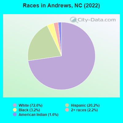
- 1,54872.6%White alone
- 43120.2%Hispanic
- 683.2%Black alone
- 462.2%Two or more races
- 351.6%American Indian alone
Races in Andrews detailed stats: ancestries, foreign born residents, place of birth
According to our research of North Carolina and other state lists, there were 17 registered sex offenders living in Andrews, North Carolina as of May 20, 2024.
The ratio of all residents to sex offenders in Andrews is 125 to 1.
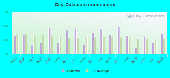
Type |
2009 |
2010 |
2011 |
2012 |
2013 |
2014 |
2015 |
2016 |
2017 |
2018 |
2019 |
2020 |
2021 |
2022 |
|---|---|---|---|---|---|---|---|---|---|---|---|---|---|---|
| Murders (per 100,000) | 0 (0.0) | 0 (0.0) | 0 (0.0) | 0 (0.0) | 0 (0.0) | 0 (0.0) | 0 (0.0) | 0 (0.0) | 0 (0.0) | 1 (54.8) | 0 (0.0) | 0 (0.0) | 0 (0.0) | 0 (0.0) |
| Rapes (per 100,000) | 3 (176.5) | 0 (0.0) | 0 (0.0) | 1 (56.0) | 0 (0.0) | 0 (0.0) | 0 (0.0) | 1 (57.3) | 1 (55.6) | 0 (0.0) | 0 (0.0) | 1 (53.9) | 0 (0.0) | 4 (234.3) |
| Robberies (per 100,000) | 2 (117.6) | 0 (0.0) | 1 (55.4) | 1 (56.0) | 1 (57.4) | 1 (57.1) | 0 (0.0) | 0 (0.0) | 2 (111.1) | 0 (0.0) | 0 (0.0) | 1 (53.9) | 0 (0.0) | 0 (0.0) |
| Assaults (per 100,000) | 5 (294.1) | 3 (168.4) | 9 (498.9) | 8 (448.2) | 1 (57.4) | 3 (171.3) | 9 (512.5) | 3 (171.8) | 3 (166.7) | 0 (0.0) | 0 (0.0) | 1 (53.9) | 4 (214.7) | 2 (117.2) |
| Burglaries (per 100,000) | 11 (647.1) | 6 (336.9) | 25 (1,386) | 27 (1,513) | 6 (344.2) | 32 (1,828) | 23 (1,310) | 16 (916.4) | 18 (1,000) | 5 (274.1) | 2 (108.8) | 11 (593.3) | 3 (161.0) | 1 (58.6) |
| Thefts (per 100,000) | 36 (2,118) | 43 (2,414) | 52 (2,882) | 37 (2,073) | 33 (1,893) | 35 (1,999) | 64 (3,645) | 51 (2,921) | 68 (3,778) | 57 (3,125) | 36 (1,958) | 49 (2,643) | 45 (2,415) | 29 (1,699) |
| Auto thefts (per 100,000) | 2 (117.6) | 1 (56.1) | 3 (166.3) | 3 (168.1) | 1 (57.4) | 9 (514.0) | 3 (170.8) | 4 (229.1) | 13 (722.2) | 3 (164.5) | 1 (54.4) | 6 (323.6) | 2 (107.4) | 1 (58.6) |
| Arson (per 100,000) | 0 (0.0) | 0 (0.0) | 0 (0.0) | 0 (0.0) | 0 (0.0) | 0 (0.0) | 1 (56.9) | 1 (57.3) | 1 (55.6) | 0 (0.0) | 0 (0.0) | 1 (53.9) | 0 (0.0) | 1 (58.6) |
| City-Data.com crime index | 374.7 | 158.3 | 342.0 | 353.5 | 133.1 | 300.4 | 353.6 | 279.5 | 390.0 | 267.0 | 90.3 | 243.3 | 159.4 | 287.6 |
The City-Data.com crime index weighs serious crimes and violent crimes more heavily. Higher means more crime, U.S. average is 246.1. It adjusts for the number of visitors and daily workers commuting into cities.
Crime rate in Andrews detailed stats: murders, rapes, robberies, assaults, burglaries, thefts, arson
Full-time law enforcement employees in 2021, including police officers: 5 (4 officers - 3 male; 1 female).
| Officers per 1,000 residents here: | 2.15 |
| North Carolina average: | 2.27 |
 Recent articles from our blog. Our writers, many of them Ph.D. graduates or candidates, create easy-to-read articles on a wide variety of topics.

 | Retiring in NC but I can't decide where. So many great towns to choose from! (364 replies) |
| Another Retire in WNC Thread (98 replies) |
| Trying to narrow down areas (59 replies) |
| Best long-range view homes in NW NC? (25 replies) |
| Anyone who has built a home on their lot in WNC... (32 replies) |
| Andrews Airport ? (7 replies) |
Latest news from Andrews, NC collected exclusively by city-data.com from local newspapers, TV, and radio stations
Ancestries: American (32.1%), English (4.9%), Irish (2.8%), Italian (2.5%), Scotch-Irish (2.4%), German (1.5%).
Current Local Time: EST time zone
Incorporated in 1905
Elevation: 2350 feet
Land area: 1.36 square miles.
Population density: 1,247 people per square mile (low).
208 residents are foreign born (8.8% Latin America).
| This town: | 9.8% |
| North Carolina: | 8.3% |
Median real estate property taxes paid for housing units with mortgages in 2022: $1,361 (0.7%)
Median real estate property taxes paid for housing units with no mortgage in 2022: $674 (0.6%)
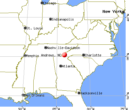
Nearest city with pop. 50,000+: Knoxville, TN  (53.9 miles , pop. 173,890).
Nearest city with pop. 200,000+: Atlanta, GA (104.9 miles , pop. 416,474).
Nearest city with pop. 1,000,000+: Chicago, IL (504.3 miles , pop. 2,896,016).
Nearest cities:
), )Latitude: 35.20 N, Longitude: 83.83 W
Area code: 828
Andrews, North Carolina accommodation & food services, waste management - Economy and Business Data
| Here: | 3.3% |
| North Carolina: | 3.2% |
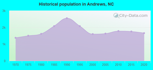
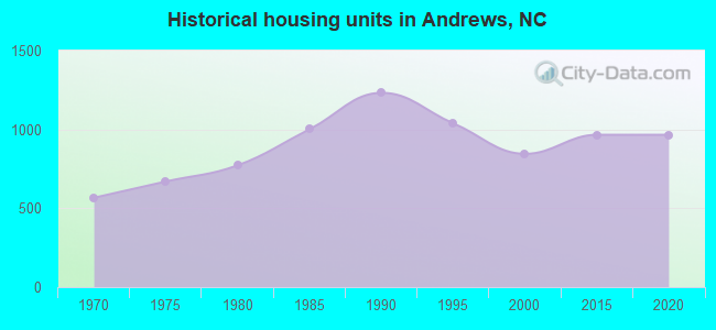
Population change in the 1990s: +166 (+11.6%).

- Construction (16.2%)
- Health care (12.1%)
- Apparel (9.1%)
- Accommodation & food services (5.9%)
- Food & beverage stores (5.5%)
- Textile mills & textile products (3.9%)
- Educational services (3.7%)
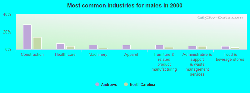
- Construction (28.2%)
- Health care (6.8%)
- Machinery (5.3%)
- Apparel (5.0%)
- Furniture & related product manufacturing (5.0%)
- Administrative & support & waste management services (4.0%)
- Food & beverage stores (3.4%)
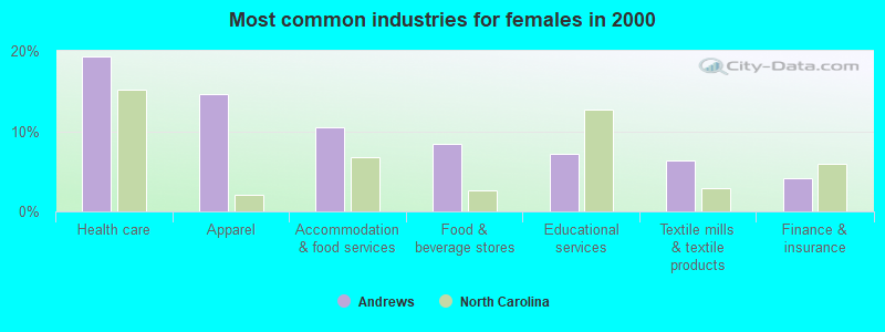
- Health care (19.2%)
- Apparel (14.6%)
- Accommodation & food services (10.5%)
- Food & beverage stores (8.4%)
- Educational services (7.1%)
- Textile mills & textile products (6.3%)
- Finance & insurance (4.2%)
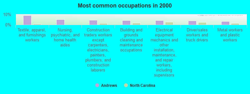
- Textile, apparel, and furnishings workers (9.1%)
- Nursing, psychiatric, and home health aides (5.2%)
- Construction traders workers except carpenters, electricians, painters, plumbers, and construction laborers (4.6%)
- Building and grounds cleaning and maintenance occupations (4.3%)
- Electrical equipment mechanics and other installation, maintenance, and repair workers, including supervisors (4.1%)
- Driver/sales workers and truck drivers (3.9%)
- Metal workers and plastic workers (3.4%)
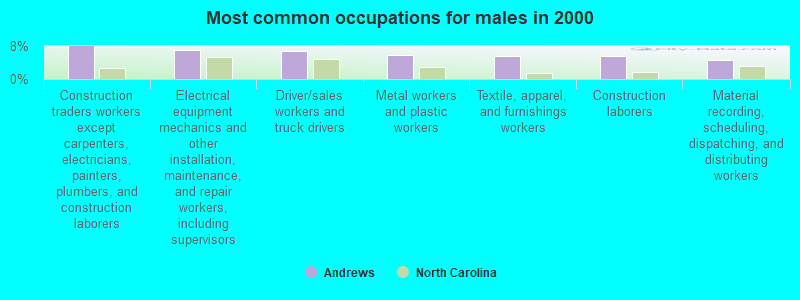
- Construction traders workers except carpenters, electricians, painters, plumbers, and construction laborers (8.0%)
- Electrical equipment mechanics and other installation, maintenance, and repair workers, including supervisors (7.1%)
- Driver/sales workers and truck drivers (6.8%)
- Metal workers and plastic workers (5.9%)
- Textile, apparel, and furnishings workers (5.6%)
- Construction laborers (5.6%)
- Material recording, scheduling, dispatching, and distributing workers (4.6%)
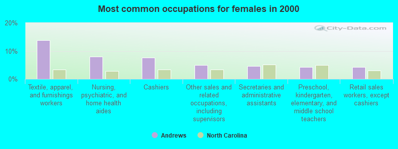
- Textile, apparel, and furnishings workers (13.8%)
- Nursing, psychiatric, and home health aides (7.9%)
- Cashiers (7.5%)
- Other sales and related occupations, including supervisors (5.0%)
- Secretaries and administrative assistants (4.6%)
- Preschool, kindergarten, elementary, and middle school teachers (4.2%)
- Retail sales workers, except cashiers (4.2%)
Average climate in Andrews, North Carolina
Based on data reported by over 4,000 weather stations


|
|


Tornado activity:
Andrews-area historical tornado activity is near North Carolina state average. It is 11% smaller than the overall U.S. average.
On 4/3/1974, a category F4 (max. wind speeds 207-260 mph) tornado 7.8 miles away from the Andrews town center killed 4 people and injured 26 people and caused between $5,000,000 and $50,000,000 in damages.
On 2/21/1993, a category F3 (max. wind speeds 158-206 mph) tornado 20.6 miles away from the town center injured 17 people and caused between $50,000 and $500,000 in damages.
Earthquake activity:
Andrews-area historical earthquake activity is significantly above North Carolina state average. It is 65% greater than the overall U.S. average.On 11/30/1973 at 07:48:41, a magnitude 4.7 (4.7 MB, 4.6 ML, Class: Light, Intensity: IV - V) earthquake occurred 42.1 miles away from the city center
On 4/29/2003 at 08:59:39, a magnitude 4.9 (4.4 MB, 4.6 MW, 4.9 LG) earthquake occurred 113.4 miles away from Andrews center
On 8/2/1974 at 08:52:09, a magnitude 4.9 (4.3 MB, 4.9 LG) earthquake occurred 119.4 miles away from the city center
On 8/9/2020 at 12:07:37, a magnitude 5.1 (5.1 MW, Depth: 4.7 mi, Class: Moderate, Intensity: VI - VII) earthquake occurred 176.8 miles away from the city center
On 7/27/1980 at 18:52:21, a magnitude 5.2 (5.1 MB, 4.7 MS, 5.0 UK, 5.2 UK) earthquake occurred 207.9 miles away from Andrews center
On 12/12/2018 at 09:14:43, a magnitude 4.4 (4.4 MW, Depth: 4.9 mi) earthquake occurred 58.5 miles away from the city center
Magnitude types: regional Lg-wave magnitude (LG), body-wave magnitude (MB), local magnitude (ML), surface-wave magnitude (MS), moment magnitude (MW)
Natural disasters:
The number of natural disasters in Cherokee County (8) is smaller than the US average (15).Major Disasters (Presidential) Declared: 4
Emergencies Declared: 2
Causes of natural disasters: Floods: 3, Storms: 3, Tornadoes: 2, Blizzard: 1, Hurricane: 1, Snowfall: 1, Wind: 1, Winter Storm: 1, Other: 1 (Note: some incidents may be assigned to more than one category).
Hospitals and medical centers in Andrews:
Airports located in Andrews:
- Western Carolina Regional Airport (RHP) (Runways: 1, Air Taxi Ops: 1,000, Itinerant Ops: 5,000, Local Ops: 14,000, Military Ops: 500)
Colleges/universities with over 2000 students nearest to Andrews:
- Western Carolina University (about 40 miles; Cullowhee, NC; Full-time enrollment: 8,684)
- Piedmont College (about 47 miles; Demorest, GA; FT enrollment: 2,251)
- University of North Georgia (about 48 miles; Dahlonega, GA; FT enrollment: 12,445)
- The University of Tennessee-Knoxville (about 53 miles; Knoxville, TN; FT enrollment: 25,483)
- Pellissippi State Community College (about 56 miles; Knoxville, TN; FT enrollment: 7,271)
- Lee University (about 60 miles; Cleveland, TN; FT enrollment: 4,422)
- Cleveland State Community College (about 60 miles; Cleveland, TN; FT enrollment: 2,500)
Public high school in Andrews:
- ANDREWS HIGH (Location: 50 HIGH SCHOOL DRIVE, Grades: 9-12)
Public elementary/middle schools in Andrews:
- ANDREWS ELEMENTARY (Location: 205 JEAN CHRISTY AVE., Grades: PK-5)
- ANDREWS MIDDLE (Location: 2750 BUSINESS HWY 19, Grades: 6-8)
Points of interest:
Notable locations in Andrews: Georgia State Prison Camp (A), Andrews Plaza (B). Display/hide their locations on the map
Streams, rivers, and creeks: Britton Creek (A), Town Branch (B). Display/hide their locations on the map
Hotel: Andrew's Valley Inn (138 Country Hearth Lane).
Birthplace of: Tina Gordon - Stock car racing driver.
Drinking water stations with addresses in Andrews and their reported violations in the past:
ANDREWS, TOWN OF (Population served: 3,250, Surface water):Past monitoring violations:
- Monitoring and Reporting (DBP) - Between OCT-2006 and DEC-2006, Contaminant: Total Haloacetic Acids (HAA5). Follow-up actions: St Public Notif requested (MAR-05-2007), St Formal NOV issued (MAR-05-2007), St Compliance achieved (DEC-06-2007)
- Monitoring and Reporting (DBP) - Between OCT-2006 and DEC-2006, Contaminant: TTHM. Follow-up actions: St Public Notif requested (MAR-05-2007), St Formal NOV issued (MAR-05-2007), St Compliance achieved (DEC-06-2007)
- Monthly Turbidity Exceed (Enhanced SWTR) - In JAN-2005, Contaminant: IESWTR. Follow-up actions: St Formal NOV issued (FEB-09-2005), St Public Notif requested (FEB-09-2005), St Compliance achieved (FEB-28-2005)
- 26 regular monitoring violations
| This town: | 2.2 people |
| North Carolina: | 2.5 people |
| This town: | 57.9% |
| Whole state: | 66.7% |
| This town: | 4.1% |
| Whole state: | 5.9% |
Likely homosexual households (counted as self-reported same-sex unmarried-partner households)
- Lesbian couples: 0.3% of all households
- Gay men: 0.3% of all households
4 people in group homes intended for adults in 2010
72 people in nursing homes in 2000
5 people in other noninstitutional group quarters in 2000
Banks with branches in Andrews (2011 data):
- PNC Bank, National Association: Andrews Branch at 1090 Main Street, branch established on 1924/01/01. Info updated 2012/03/20: Bank assets: $263,309.6 mil, Deposits: $197,343.0 mil, headquarters in Wilmington, DE, positive income, Commercial Lending Specialization, 3085 total offices, Holding Company: Pnc Financial Services Group, Inc., The
- United Community Bank: Andrews Branch at 732 Main Street, branch established on 1987/08/24. Info updated 2009/06/23: Bank assets: $6,977.4 mil, Deposits: $6,170.1 mil, headquarters in Blairsville, GA, negative income in the last year, Commercial Lending Specialization, 106 total offices, Holding Company: United Community Banks, Inc.
For population 15 years and over in Andrews:
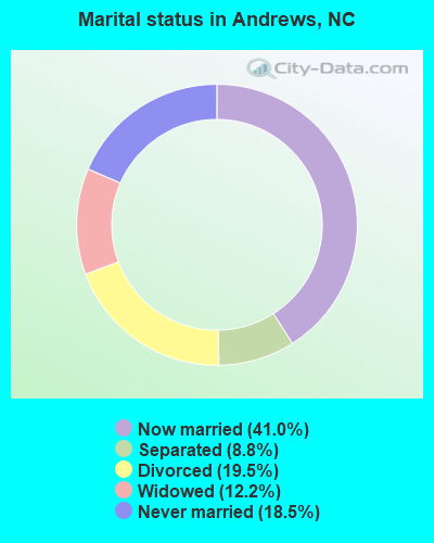
- Never married: 18.5%
- Now married: 41.0%
- Separated: 8.8%
- Widowed: 12.2%
- Divorced: 19.5%
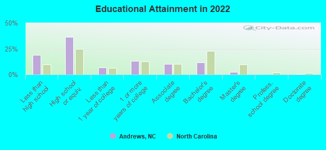
For population 25 years and over in Andrews:
- High school or higher: 79.4%
- Bachelor's degree or higher: 13.4%
- Graduate or professional degree: 2.8%
- Unemployed: 8.9%
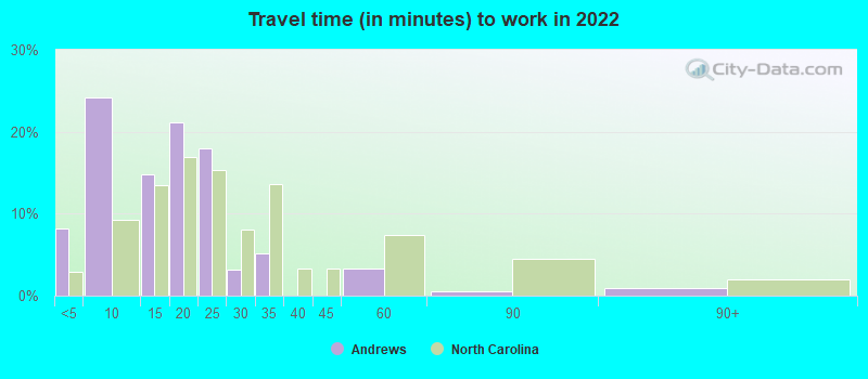
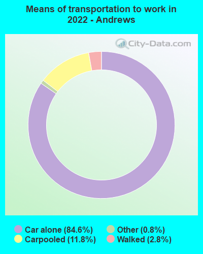
- Mean travel time to work (commute): 10.9 minutes
| Here: | 11.7 |
| North Carolina average: | 11.7 |
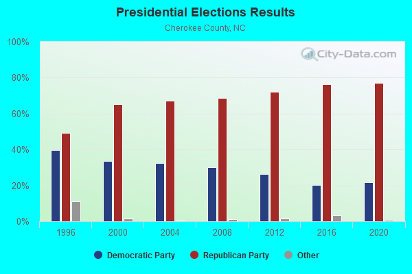
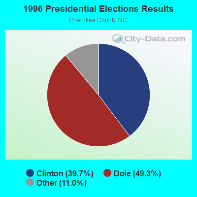
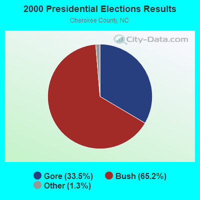
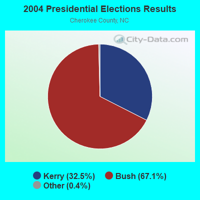
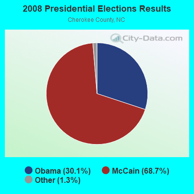
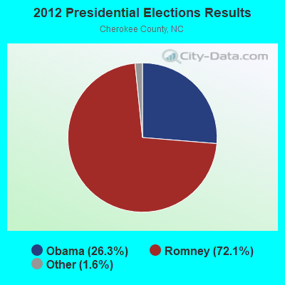
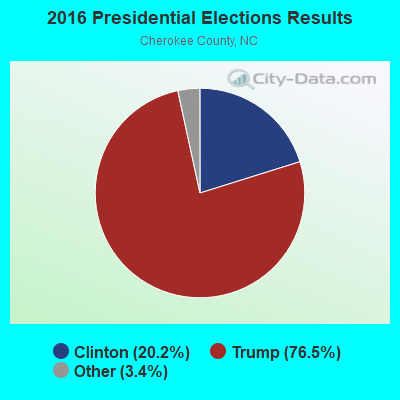
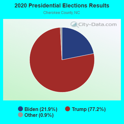
Graphs represent county-level data. Detailed 2008 Election Results
Religion statistics for Andrews, NC (based on Cherokee County data)
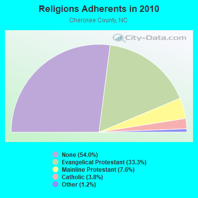
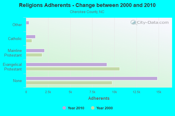
| Religion | Adherents | Congregations |
|---|---|---|
| Evangelical Protestant | 9,146 | 60 |
| Mainline Protestant | 2,085 | 10 |
| Catholic | 1,054 | 2 |
| Other | 329 | 2 |
| Orthodox | 20 | 1 |
| None | 14,857 | - |
Food Environment Statistics:
| Cherokee County: | 1.89 / 10,000 pop. |
| North Carolina: | 2.05 / 10,000 pop. |
| This county: | 0.38 / 10,000 pop. |
| State: | 0.14 / 10,000 pop. |
| Cherokee County: | 0.76 / 10,000 pop. |
| North Carolina: | 0.92 / 10,000 pop. |
| Cherokee County: | 6.81 / 10,000 pop. |
| State: | 4.75 / 10,000 pop. |
| Here: | 8.70 / 10,000 pop. |
| State: | 7.57 / 10,000 pop. |
| This county: | 11.3% |
| North Carolina: | 9.8% |
| Cherokee County: | 24.7% |
| North Carolina: | 28.3% |
| This county: | 12.9% |
| State: | 15.6% |
Health and Nutrition:
| Here: | 46.1% |
| State: | 48.9% |
| Andrews: | 38.8% |
| North Carolina: | 46.1% |
| Here: | 28.7 |
| North Carolina: | 28.8 |
| This city: | 24.7% |
| North Carolina: | 20.7% |
| Andrews: | 12.5% |
| North Carolina: | 10.7% |
| Andrews: | 6.9 |
| North Carolina: | 6.8 |
| This city: | 32.6% |
| North Carolina: | 33.7% |
| Here: | 49.4% |
| North Carolina: | 55.8% |
| Andrews: | 73.6% |
| North Carolina: | 79.7% |
More about Health and Nutrition of Andrews, NC Residents
| Local government employment and payroll (March 2022) | |||||
| Function | Full-time employees | Monthly full-time payroll | Average yearly full-time wage | Part-time employees | Monthly part-time payroll |
|---|---|---|---|---|---|
| Water Supply | 7 | $23,336 | $40,005 | 2 | $2,852 |
| Police Protection - Officers | 6 | $22,096 | $44,192 | 1 | $487 |
| Parks and Recreation | 3 | $8,115 | $32,460 | 0 | $0 |
| Other and Unallocable | 3 | $9,588 | $38,352 | 1 | $930 |
| Financial Administration | 3 | $8,848 | $35,392 | 1 | $882 |
| Sewerage | 2 | $7,079 | $42,474 | 0 | $0 |
| Solid Waste Management | 2 | $5,863 | $35,178 | 0 | $0 |
| Streets and Highways | 1 | $2,298 | $27,576 | 0 | $0 |
| Other Government Administration | 0 | $0 | 6 | $2,600 | |
| Totals for Government | 27 | $87,225 | $38,767 | 11 | $7,751 |
Andrews government finances - Expenditure in 2017 (per resident):
- Construction - Regular Highways: $81,000 ($47.93)
Libraries: $35,000 ($20.71)
- Current Operations - Water Utilities: $1,185,000 ($701.18)
Liquor Stores: $584,000 ($345.56)
Police Protection: $492,000 ($291.12)
Financial Administration: $440,000 ($260.36)
Housing and Community Development: $208,000 ($123.08)
Parks and Recreation: $204,000 ($120.71)
Regular Highways: $172,000 ($101.78)
Libraries: $141,000 ($83.43)
Natural Resources - Other: $114,000 ($67.46)
Local Fire Protection: $13,000 ($7.69)
- Intergovernmental to Local - Other - Health - Other: $2,000 ($1.18)
- Other Capital Outlay - Police Protection: $5,000 ($2.96)
- Total Salaries and Wages: $186,000 ($110.06)
- Water Utilities - Interest on Debt: $23,000 ($13.61)
Andrews government finances - Revenue in 2017 (per resident):
- Charges - Solid Waste Management: $120,000 ($71.01)
Parks and Recreation: $16,000 ($9.47)
Miscellaneous Commercial Activities: $5,000 ($2.96)
- Miscellaneous - General Revenue - Other: $39,000 ($23.08)
Interest Earnings: $0 ($0.00)
- Revenue - Water Utilities: $961,000 ($568.64)
Liquor Stores: $577,000 ($341.42)
- State Intergovernmental - Other: $389,000 ($230.18)
General Local Government Support: $132,000 ($78.11)
Highways: $55,000 ($32.54)
- Tax - Property: $634,000 ($375.15)
General Sales and Gross Receipts: $519,000 ($307.10)
Occupation and Business License - Other: $3,000 ($1.78)
Other License: $1,000 ($0.59)
Andrews government finances - Debt in 2017 (per resident):
- Long Term Debt - Beginning Outstanding - Unspecified Public Purpose: $569,000 ($336.69)
Outstanding Unspecified Public Purpose: $525,000 ($310.65)
Retired Unspecified Public Purpose: $44,000 ($26.04)
| Businesses in Andrews, NC | ||||
| Name | Count | Name | Count | |
|---|---|---|---|---|
| Ace Hardware | 1 | Lane Furniture | 1 | |
| FedEx | 1 | McDonald's | 1 | |
| H&R Block | 1 | Subway | 1 | |
| Kincaid | 1 | U-Haul | 2 | |
Strongest AM radio stations in Andrews:
- WKRK (1320 AM; 5 kW; MURPHY, NC; Owner: RADFORD COMMUNICATIONS, INC.)
- WKVL (850 AM; daytime; 50 kW; KNOXVILLE, TN; Owner: HORNE RADIO, LLC)
- WLFJ (660 AM; daytime; 50 kW; GREENVILLE, SC; Owner: CLEAR CHANNEL BROADCASTING LICENSES, INC.)
- WCNN (680 AM; 50 kW; NORTH ATLANTA, GA; Owner: DICKEY BROADCASTING COMPANY)
- WCVP (600 AM; 1 kW; MURPHY, NC; Owner: CHEROKEE BROADCASTING COMPANY)
- WCSZ (1070 AM; 50 kW; SANS SOUCI, SC; Owner: WHYZ RADIO, L.P.)
- WSB (750 AM; 50 kW; ATLANTA, GA; Owner: CXR HOLDINGS, INC.)
- WGST (640 AM; 50 kW; ATLANTA, GA; Owner: CITICASTERS LICENSES, L.P.)
- WFGW (1010 AM; 50 kW; BLACK MOUNTAIN, NC; Owner: BLUE RIDGE BROADCASTING CORP.)
- WFLI (1070 AM; 50 kW; LOOKOUT MOUNTAIN, TN; Owner: WFLI, INC.)
- WWAM (820 AM; daytime; 50 kW; JASPER, TN; Owner: SHELTON BROADCASTING SYSTEM)
- WFTD (1080 AM; daytime; 50 kW; MARIETTA, GA; Owner: PRIETO ENTERPRISES, INC.)
- WPFJ (1480 AM; 5 kW; FRANKLIN, NC; Owner: DRAKE ENTERPRISES, LTD.)
Strongest FM radio stations in Andrews:
- WCVP-FM (95.9 FM; ROBBINSVILLE, NC; Owner: CHEROKEE BROADCASTING COMPANY, INC.)
- WFQS (91.3 FM; FRANKLIN, NC; Owner: WESTERN NORTH CAROLINA PUBLIC RADIO)
- W237AR (95.3 FM; HAZELWOOD, ETC., NC; Owner: WESTERN NORTH CAROLINA PUBLIC RADIO)
- WNCC-FM (96.7 FM; FRANKLIN, NC; Owner: SUTTON RADIOCASTING CORPORATION)
- WCNG (102.7 FM; MURPHY, NC; Owner: CHEROKEE BROADCASTING CO., INC.)
- WIVK-FM (107.7 FM; KNOXVILLE, TN; Owner: CITADEL BROADCASTING COMPANY)
- WRBN (104.1 FM; CLAYTON, GA; Owner: SUTTON RADIOCASTING CORPORATION)
- WWST (102.1 FM; SEVIERVILLE, TN; Owner: JOURNAL BROADCAST CORPORATION)
- WKSF (99.9 FM; ASHEVILLE, NC; Owner: CAPSTAR TX LIMITED PARTNERSHIP)
- WOKI-FM (100.3 FM; OAK RIDGE, TN; Owner: OAK RIDGE FM, INC.)
- W269AY (101.7 FM; HIGHLANDS, NC; Owner: WESTERN NORTH CAROLINA PUBLIC RADIO)
- WHLC (104.5 FM; HIGHLANDS, NC; Owner: CHARISMA RADIO CORP.)
- W277AL (103.3 FM; HIGHLANDS, NC; Owner: CHARISMA RADIO CORPORATION)
- W220CD (91.9 FM; ENKA, NC; Owner: CALVARY CHAPEL OF TWIN FALLS, INC.)
- WSEV-FM (105.5 FM; GATLINBURG, TN; Owner: EAST TENNESSEE RADIO GROUP, L.P.)
- WUOT (91.9 FM; KNOXVILLE, TN; Owner: UNIVERSITY OF TENNESSEE)
- WWCU (90.5 FM; CULLOWHEE, NC; Owner: WESTERN CAROLINA UNIVERSITY)
- WTFH (89.9 FM; HELEN, GA; Owner: TOCCOA FALLS COLLEGE)
- W212AB (90.3 FM; ROBBINSVILLE, ETC., NC; Owner: THE MASTER'S MISSION)
TV broadcast stations around Andrews:
- W50AB (Channel 50; HIAWASSEE, GA; Owner: GEORGIA PUBLIC TELECOMMUNICATIONS COMMISSION)
- W59AD (Channel 59; ANDREWS, ETC., NC; Owner: UNIVERSITY OF NORTH CAROLINA)
- WDTT-LP (Channel 38; LENOIR CITY, TN; Owner: WORD OF GOD FELLOWSHIP, INC.)
- W11AQ (Channel 11; ROBBINSVILLE, ETC., NC; Owner: WLOS LICENSEE, LLC)
- W08BH (Channel 8; ANDREWS, ETC., NC; Owner: WYFF HEARST-ARGYLE TELEVISION, INC.)
- W31AN (Channel 31; MURPHY, NC; Owner: UNIVERSITY OF NORTH CAROLINA)
- W28AN (Channel 28; FRANKLIN, NC; Owner: UNIVERSITY OF NORTH CAROLINA)
- W42AT (Channel 42; HAYESVILLE, NC; Owner: UNIVERSITY OF NORTH CAROLINA)
Andrews fatal accident list:
May 5, 2012 04:05 PM, Us-19, Whitaker Rd, Lat: 35.204689, Lon: -83.811242, Vehicles: 2, Persons: 3, Fatalities: 1
Mar 9, 2011 07:18 AM, Rp 1388, Rp 1405, Vehicles: 1, Persons: 1, Fatalities: 1
Oct 1, 2003 07:24 AM, Locust Street, Vehicles: 2, Persons: 2, Fatalities: 1, Drunk persons involved: 1
Dec 5, 2003 05:57 PM, Us-19, Vehicles: 1, Persons: 2, Pedestrians: 1, Fatalities: 1, Drunk persons involved: 1
Jun 1, 1976 11:15 PM, Vehicles: 2, Persons: 6, Fatalities: 1
Jun 1, 1975 11:15 PM, Vehicles: 2, Persons: 6, Fatalities: 1
- National Bridge Inventory (NBI) Statistics
- 33Number of bridges
- 272ft / 83.3mTotal length
- 56,640Total average daily traffic
- 5,042Total average daily truck traffic
- New bridges - historical statistics
- 21920-1929
- 41950-1959
- 71960-1969
- 101970-1979
- 41980-1989
- 11990-1999
- 42000-2009
- 12010-2019
FCC Registered Antenna Towers:
14 (See the full list of FCC Registered Antenna Towers in Andrews)FCC Registered Broadcast Land Mobile Towers:
9 (See the full list of FCC Registered Broadcast Land Mobile Towers in Andrews, NC)FCC Registered Microwave Towers:
11 (See the full list of FCC Registered Microwave Towers in this town)FCC Registered Maritime Coast & Aviation Ground Towers:
4 (See the full list of FCC Registered Maritime Coast & Aviation Ground Towers)FCC Registered Amateur Radio Licenses:
49 (See the full list of FCC Registered Amateur Radio Licenses in Andrews)FAA Registered Aircraft:
5- Aircraft: BEECH A23 (Category: Land, Seats: 4, Weight: Up to 12,499 Pounds, Speed: 114 mph), Engine: CONT MOTOR IO-346 SERIES (165 HP) (Reciprocating)
N-Number: 1487L, N1487L, N-1487L, Serial Number: M-887, Year manufactured: 1965, Airworthiness Date: 10/15/1965, Certificate Issue Date: 01/16/2013
Registrant (Co-Owned): James T Wilson, Po Box 855, Andrews, NC 28901, Other Owners: Ronald Clontz - Aircraft: CESSNA 177RG (Category: Land, Seats: 4, Weight: Up to 12,499 Pounds, Speed: 120 mph), Engine: LYCOMING IO-360-A1B6D (200 HP) (Reciprocating)
N-Number: 1995Q, N1995Q, N-1995Q, Serial Number: 177RG0395, Year manufactured: 1973, Airworthiness Date: 07/27/1973, Certificate Issue Date: 01/30/2020
Registrant (Individual): Jonathan P Hooper, 5835 Airport Rd, Andrews, NC 28901 - Aircraft: AEROTEK PITTS SPECIAL S-1S (Category: Land, Weight: Up to 12,499 Pounds, Speed: 115 mph), Engine: LYCOMING I0360 SER (180 HP) (Reciprocating)
N-Number: 29JL, N29JL, N-29JL, Serial Number: 1-0024, Year manufactured: 1974, Airworthiness Date: 08/30/1974, Certificate Issue Date: 02/26/2015
Registrant (Individual): Justin B Griffin, 77 Smith Knob Rd, Andrews, NC 28901 - Aircraft: PIPER J3C-65 (Category: Land, Seats: 2, Weight: Up to 12,499 Pounds, Speed: 67 mph), Engine: CONT MOTOR A&C65 SERIES (65 HP) (Reciprocating)
N-Number: 3303N, N3303N, N-3303N, Serial Number: 22498, Year manufactured: 1946, Airworthiness Date: 02/14/1962, Certificate Issue Date: 01/11/1993
Registrant (Co-Owned): Edgar A Iii Wood, Po Box 340, Andrews, NC 28901, Other Owners: William Keith Wood - Aircraft: LOCKHEED 1329-23E (Category: Land, Engines: 4, Seats: 12, Weight: 20,000+ Pounds), Engine: P & W JT12A-6 6A (3000 Pounds of Thrust) (Turbo-jet)
N-Number: 104CE, N104CE, N-104CE, Serial Number: 5108, Year manufactured: 1968, Airworthiness Date: 01/26/1968, Certificate Issue Date: 02/26/2001
Registrant (Corporation): Wilson Air Services LLC, 5840 Airport Rd, Andrews, NC 28901
Deregistered: Cancel Date: 08/11/2016
2003 - 2018 National Fire Incident Reporting System (NFIRS) incidents
- Fire incident types reported to NFIRS in Andrews, NC
- 5647.9%Structure Fires
- 3933.3%Outside Fires
- 1815.4%Mobile Property/Vehicle Fires
- 43.4%Other
 According to the data from the years 2003 - 2018 the average number of fires per year is 7. The highest number of fires - 37 took place in 2016, and the least - 0 in 2009. The data has a growing trend.
 When looking into fire subcategories, the most reports belonged to: Structure Fires (47.9%), and Outside Fires (33.3%).
| Most common first names in Andrews, NC among deceased individuals | ||
| Name | Count | Lived (average) |
|---|---|---|
| James | 61 | 73.4 years |
| William | 51 | 77.3 years |
| John | 45 | 75.0 years |
| Mary | 40 | 80.4 years |
| Robert | 39 | 73.2 years |
| Charles | 29 | 72.5 years |
| Frank | 16 | 79.7 years |
| Paul | 15 | 71.4 years |
| Thomas | 15 | 76.6 years |
| Joseph | 15 | 74.8 years |
| Most common last names in Andrews, NC among deceased individuals | ||
| Last name | Count | Lived (average) |
|---|---|---|
| West | 36 | 76.4 years |
| Adams | 29 | 77.9 years |
| Hardin | 28 | 78.0 years |
| Jones | 27 | 79.4 years |
| Wilson | 22 | 77.4 years |
| Truett | 21 | 74.1 years |
| Phillips | 20 | 70.3 years |
| Morgan | 17 | 78.3 years |
| Gregory | 16 | 81.8 years |
| Ledford | 16 | 77.6 years |
- 72.6%Electricity
- 14.8%Fuel oil, kerosene, etc.
- 11.2%Bottled, tank, or LP gas
- 1.5%No fuel used
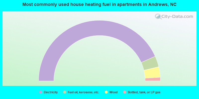
- 86.7%Electricity
- 5.8%Fuel oil, kerosene, etc.
- 5.6%Wood
- 1.9%Bottled, tank, or LP gas
Andrews compared to North Carolina state average:
- Median household income below state average.
- Median house value significantly below state average.
- Black race population percentage significantly below state average.
- Hispanic race population percentage above state average.
- Foreign-born population percentage above state average.
- Length of stay since moving in significantly above state average.
- Number of rooms per house below state average.
- Institutionalized population percentage above state average.
- Number of college students below state average.
- Percentage of population with a bachelor's degree or higher below state average.

|
Total of 3 patent applications in 2008-2024.