Arietta, New York
Submit your own pictures of this town and show them to the world
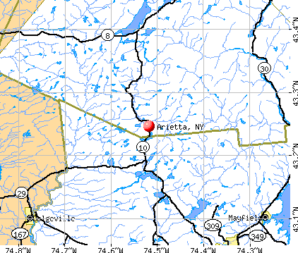
- OSM Map
- General Map
- Google Map
- MSN Map
Population change since 2000: +3.8%
 |
| Males: 147 | |
| Females: 157 |
| Median resident age: | 50.0 years |
| New York median age: | 40.7 years |
Zip codes: 12139.
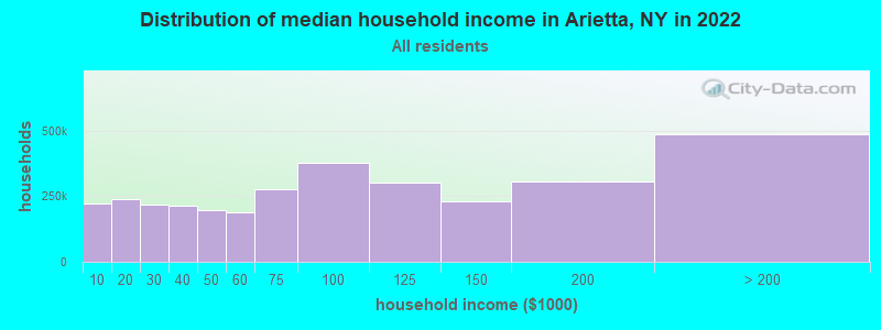
| Arietta: | $73,667 |
| NY: | $79,557 |
Estimated per capita income in 2022: $51,078 (it was $25,378 in 2000)
Arietta town income, earnings, and wages data
Estimated median house or condo value in 2022: $224,009 (it was $92,500 in 2000)
| Arietta: | $224,009 |
| NY: | $400,400 |
Mean prices in 2022: all housing units: $276,911; detached houses: $295,280; townhouses or other attached units: $526,676; in 2-unit structures: $315,059; mobile homes: $136,992
Compare current foreclosures near your location:
| Photo | Address | Area | Beds / Baths | Price | Details |
|---|---|---|---|---|---|

|
#1
S High St
Columbus, OH 43207
|
1,678 sq. feet
|
2 baths 4 beds |
$31,900
|
show details |

|
#2
Bayberry Cir
Columbus, OH 43207
|
1,564 sq. feet
|
1 baths 3 beds |
$127,500
|
show details |

|
#3
E 21st Ave
Columbus, OH 43211
|
1,061 sq. feet
|
1 baths 3 beds |
$179,900
|
show details |

|
#4
Fairfield Ave
Columbus, OH 43203
|
984 sq. feet
|
1 baths 2 beds |
show details | |

|
#5
Executive Ct
Westerville, OH 43081
|
1,811 sq. feet
|
2 baths 3 beds |
show details | |

|
#6
Hiawatha Park Dr
Columbus, OH 43211
|
1,278 sq. feet
|
1 baths 4 beds |
show details | |

|
#7
Fergus Rd
Grove City, OH 43123
|
3,312 sq. feet
|
2 baths 4 beds |
show details | |

|
#8
Cannonade Ct
Columbus, OH 43230
|
2,023 sq. feet
|
2 baths 3 beds |
show details | |

|
#9
E Welch Ave
Columbus, OH 43207
|
1,864 sq. feet
|
2 baths 4 beds |
show details | |

|
#10
S Hague Ave
Columbus, OH 43204
|
979 sq. feet
|
1 baths 2 beds |
show details |
| Photo | Address | Area | Beds / Baths | Price | Details |
|---|---|---|---|---|---|

|
#11
E Lincoln Ave
Columbus, OH 43214
|
874 sq. feet
|
1 baths 3 beds |
show details | |

|
#12
S Champion Ave
Columbus, OH 43207
|
1,157 sq. feet
|
1 baths 2 beds |
show details | |

|
#13
Chester Rd
Columbus, OH 43221
|
3,300 sq. feet
|
4 baths 5 beds |
show details | |

|
#14
Striebel Ct
Columbus, OH 43227
|
925 sq. feet
|
1 baths 3 beds |
show details | |

|
#15
Lehner Rd
Columbus, OH 43224
|
1,628 sq. feet
|
2 baths 4 beds |
show details | |

|
#16
Upton Rd E
Columbus, OH 43232
|
852 sq. feet
|
1 baths 3 beds |
show details | |

|
#17
Armada Rd
Columbus, OH 43232
|
1,028 sq. feet
|
1 baths 4 beds |
show details | |

|
#18
Wrexham Ave
Columbus, OH 43223
|
1,235 sq. feet
|
1 baths 3 beds |
show details | |

|
#19
E Howard Rd
Columbus, OH 43207
|
1,056 sq. feet
|
1 baths 3 beds |
show details | |

|
#20
Summertree Ln
Westerville, OH 43081
|
2,496 sq. feet
|
2 baths 3 beds |
show details |
| Photo | Address | Area | Beds / Baths | Price | Details |
|---|---|---|---|---|---|

|
#21
London Groveport Rd
Grove City, OH 43123
|
816 sq. feet
|
1 baths 2 beds |
show details | |

|
#22
N Roys Ave
Columbus, OH 43204
|
1,248 sq. feet
|
2 baths 3 beds |
show details | |

|
#23
Chidley St
Galloway, OH 43119
|
1,502 sq. feet
|
1 baths 3 beds |
show details | |

|
#24
Glenmate Ct
Columbus, OH 43223
|
1,050 sq. feet
|
1 baths 3 beds |
show details | |

|
#25
High Free Pike
West Jefferson, OH 43162
|
1,216 sq. feet
|
2 baths 4 beds |
show details | |

|
#26
Gladys Rd
Columbus, OH 43228
|
832 sq. feet
|
1 baths 3 beds |
show details | |

|
#27
Whittman Ct
Plain City, OH 43064
|
3,186 sq. feet
|
3 baths 4 beds |
show details | |

|
#28
Hamilton Ave
Columbus, OH 43211
|
1,061 sq. feet
|
1 baths 3 beds |
show details | |

|
#29
Hildreth Ave
Columbus, OH 43203
|
1,798 sq. feet
|
2 baths 4 beds |
show details | |

|
#30
Ashgrove Dr
Grove City, OH 43123
|
1,772 sq. feet
|
2 baths 4 beds |
show details |
| Photo | Address | Area | Beds / Baths | Price | Details |
|---|---|---|---|---|---|

|
#31
S Richardson Ave
Columbus, OH 43204
|
1,520 sq. feet
|
2 baths 3 beds |
show details | |

|
#32
Kelton Ave
Columbus, OH 43206
|
1,080 sq. feet
|
1 baths 3 beds |
show details | |

|
#33
Meadowbrook Dr
Columbus, OH 43207
|
1,752 sq. feet
|
2 baths 4 beds |
show details | |

|
#34
Falls Peak Ln
Delaware, OH 43015
|
1,352 sq. feet
|
2 baths 2 beds |
show details | |

|
#35
N 18th St
Columbus, OH 43203
|
1,690 sq. feet
|
1 baths 4 beds |
show details | |

|
#36
Grasmere Ave
Columbus, OH 43211
|
720 sq. feet
|
1 baths 2 beds |
show details | |

|
#37
Huxley Dr
Columbus, OH 43227
|
1,284 sq. feet
|
1 baths 3 beds |
show details | |

|
#38
Morgan Ln
Columbus, OH 43230
|
4,619 sq. feet
|
5 baths 6 beds |
show details | |

|
#39
Allwood Ct
Columbus, OH 43231
|
1,683 sq. feet
|
2 baths 3 beds |
show details | |

|
#40
Colorado Ave
Groveport, OH 43125
|
1,502 sq. feet
|
1 baths 3 beds |
show details |
| Photo | Address | Area | Beds / Baths | Price | Details |
|---|---|---|---|---|---|

|
#41
Doral Ave
Columbus, OH 43213
|
2,124 sq. feet
|
2 baths 4 beds |
show details | |

|
#42
Beechview Dr S
Columbus, OH 43085
|
1,998 sq. feet
|
1 baths 3 beds |
show details | |

|
#43
Westrock Dr
Hilliard, OH 43026
|
1,624 sq. feet
|
2 baths 4 beds |
show details | |

|
#44
Jed Ct
Columbus, OH 43227
|
1,086 sq. feet
|
1 baths 3 beds |
show details | |

|
#45
Wendler Blvd
Columbus, OH 43230
|
1,040 sq. feet
|
1 baths 3 beds |
show details | |

|
#46
Morality Dr
Columbus, OH 43231
|
1,903 sq. feet
|
2 baths 4 beds |
show details | |

|
#47
Gertrude Dr
Columbus, OH 43227
|
1,287 sq. feet
|
1 baths 3 beds |
show details | |

|
#48
Mayflower Cir
Grove City, OH 43123
|
2,084 sq. feet
|
2 baths 4 beds |
show details | |

|
#49
Crocker Rd
Columbus, OH 43232
|
895 sq. feet
|
1 baths 3 beds |
show details | |

|
Check over 1 million property listings on Foreclosure.com!
|
browse all offers | |||

- 29898.0%White alone
- 31.0%Asian alone
- 10.3%Native Hawaiian and Other
Pacific Islander alone - 10.3%Two or more races
- 10.3%Hispanic
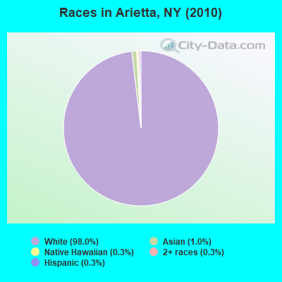
Races in Arietta detailed stats: ancestries, foreign born residents, place of birth
 Recent articles from our blog. Our writers, many of them Ph.D. graduates or candidates, create easy-to-read articles on a wide variety of topics.


Latest news from Arietta, NY collected exclusively by city-data.com from local newspapers, TV, and radio stations
Ancestries: German (28.7%), Irish (22.9%), English (20.8%), United States (12.6%), Polish (10.2%), French (9.2%).
Current Local Time: EST time zone
Land area: 317.6 square miles.
Population density: 1.0 people per square mile (very low).
3 residents are foreign born
| This town: | 1.0% |
| New York: | 20.4% |
| Arietta town: | 0.8% ($739) |
| New York: | 1.9% ($2,847) |
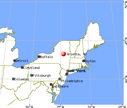
Nearest city with pop. 50,000+: Utica, NY  (44.1 miles , pop. 60,651).
Nearest city with pop. 200,000+: Rochester, NY (154.9 miles , pop. 219,773).
Nearest city with pop. 1,000,000+: Bronx, NY (188.0 miles , pop. 1,332,650).
Nearest cities:
), Latitude: 43.52 N, Longitude: 74.57 W
Area code commonly used in this area: 518

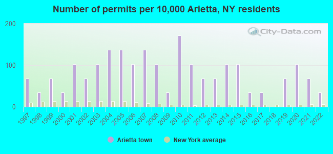
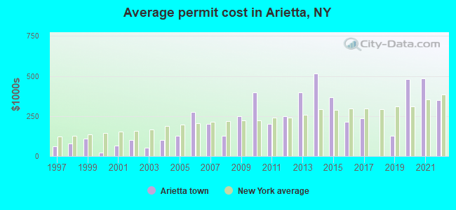
Single-family new house construction building permits:
- 2022: 1 building, cost: $350,000
- 2021: 2 buildings, average cost: $486,500
- 2020: 3 buildings, average cost: $481,200
- 2019: 2 buildings, average cost: $127,000
- 2017: 1 building, cost: $235,000
- 2016: 1 building, cost: $215,000
- 2015: 3 buildings, average cost: $366,700
- 2014: 3 buildings, average cost: $516,700
- 2013: 2 buildings, average cost: $400,000
- 2012: 2 buildings, average cost: $250,000
- 2011: 3 buildings, average cost: $200,000
- 2010: 5 buildings, average cost: $400,000
- 2009: 1 building, cost: $250,000
- 2008: 3 buildings, average cost: $125,000
- 2007: 4 buildings, average cost: $200,000
- 2006: 3 buildings, average cost: $275,000
- 2005: 4 buildings, average cost: $125,000
- 2004: 4 buildings, average cost: $100,000
- 2003: 3 buildings, average cost: $51,700
- 2002: 2 buildings, average cost: $100,000
- 2001: 3 buildings, average cost: $66,700
- 2000: 1 building, cost: $20,000
- 1999: 2 buildings, average cost: $110,000
- 1998: 1 building, cost: $79,000
- 1997: 2 buildings, average cost: $60,000
| Here: | 7.4% |
| New York: | 4.4% |
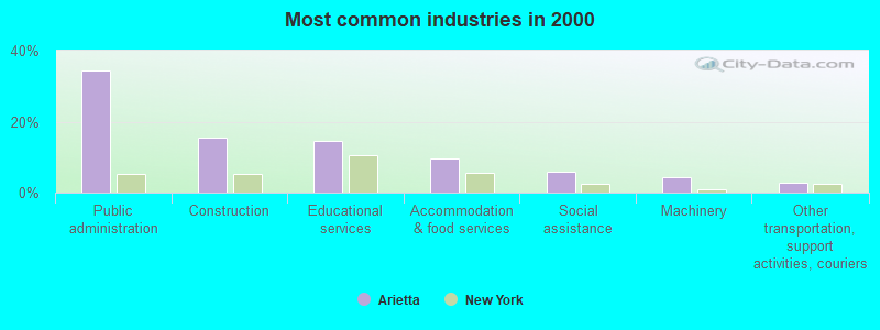
- Public administration (34.6%)
- Construction (15.4%)
- Educational services (14.7%)
- Accommodation & food services (9.6%)
- Social assistance (5.9%)
- Machinery (4.4%)
- Other transportation, support activities, couriers (2.9%)
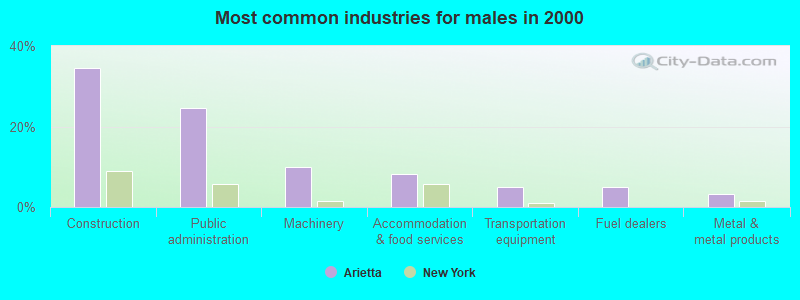
- Construction (34.4%)
- Public administration (24.6%)
- Machinery (9.8%)
- Accommodation & food services (8.2%)
- Transportation equipment (4.9%)
- Fuel dealers (4.9%)
- Metal & metal products (3.3%)
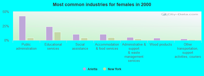
- Public administration (42.7%)
- Educational services (24.0%)
- Social assistance (10.7%)
- Accommodation & food services (10.7%)
- Administrative & support & waste management services (5.3%)
- Wood products (4.0%)
- Other transportation, support activities, couriers (2.7%)
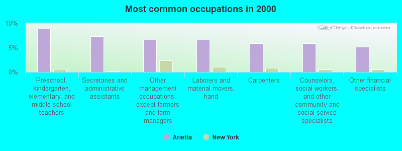
- Preschool, kindergarten, elementary, and middle school teachers (8.8%)
- Secretaries and administrative assistants (7.4%)
- Other management occupations, except farmers and farm managers (6.6%)
- Laborers and material movers, hand (6.6%)
- Carpenters (5.9%)
- Counselors, social workers, and other community and social service specialists (5.9%)
- Other financial specialists (5.1%)
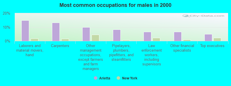
- Laborers and material movers, hand (14.8%)
- Carpenters (13.1%)
- Other management occupations, except farmers and farm managers (9.8%)
- Pipelayers, plumbers, pipefitters, and steamfitters (8.2%)
- Law enforcement workers, including supervisors (6.6%)
- Other financial specialists (6.6%)
- Top executives (4.9%)
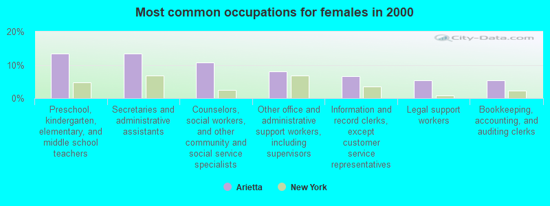
- Preschool, kindergarten, elementary, and middle school teachers (13.3%)
- Secretaries and administrative assistants (13.3%)
- Counselors, social workers, and other community and social service specialists (10.7%)
- Other office and administrative support workers, including supervisors (8.0%)
- Information and record clerks, except customer service representatives (6.7%)
- Legal support workers (5.3%)
- Bookkeeping, accounting, and auditing clerks (5.3%)
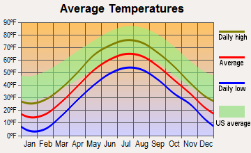
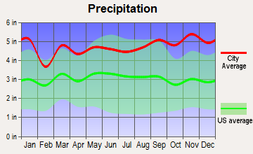
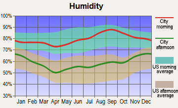
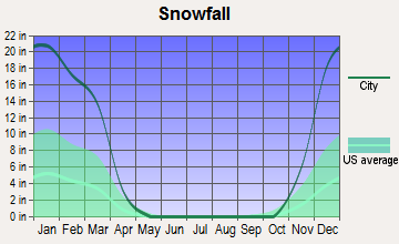
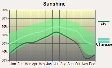
Average climate in Arietta, New York
Based on data reported by over 4,000 weather stations


(lower is better)
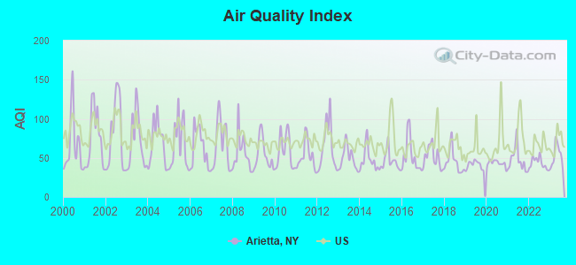
Air Quality Index (AQI) level in 2023 was 52.8. This is better than average.
| City: | 52.8 |
| U.S.: | 72.6 |
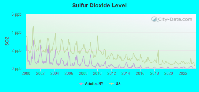
Sulfur Dioxide (SO2) [ppb] level in 2023 was 0.0978. This is significantly better than average. Closest monitor was 5.3 miles away from the city center.
| City: | 0.0978 |
| U.S.: | 1.5147 |
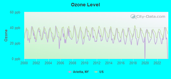
Ozone [ppb] level in 2023 was 31.2. This is about average. Closest monitor was 5.3 miles away from the city center.
| City: | 31.2 |
| U.S.: | 33.3 |
Tornado activity:
Arietta-area historical tornado activity is below New York state average. It is 79% smaller than the overall U.S. average.
On 7/10/1989, a category F4 (max. wind speeds 207-260 mph) tornado 47.5 miles away from the Arietta town center injured 20 people and caused between $5,000,000 and $50,000,000 in damages.
On 5/2/1983, a category F3 (max. wind speeds 158-206 mph) tornado 36.7 miles away from the town center caused between $5,000,000 and $50,000,000 in damages.
Earthquake activity:
Arietta-area historical earthquake activity is significantly above New York state average. It is 68% smaller than the overall U.S. average.On 10/7/1983 at 10:18:46, a magnitude 5.3 (5.1 MB, 5.3 LG, 5.1 ML, Class: Moderate, Intensity: VI - VII) earthquake occurred 32.3 miles away from Arietta center
On 4/20/2002 at 10:50:47, a magnitude 5.3 (5.3 ML, Depth: 3.0 mi) earthquake occurred 81.5 miles away from the city center
On 4/20/2002 at 10:50:47, a magnitude 5.2 (5.2 MB, 4.2 MS, 5.2 MW, 5.0 MW) earthquake occurred 79.5 miles away from the city center
On 1/19/1982 at 00:14:42, a magnitude 4.7 (4.5 MB, 4.7 MD, 4.5 LG, Class: Light, Intensity: IV - V) earthquake occurred 149.0 miles away from the city center
On 6/17/1991 at 08:53:16, a magnitude 4.1 (4.0 MB, 4.0 LG, Depth: 3.1 mi) earthquake occurred 61.5 miles away from the city center
On 10/16/2012 at 23:12:25, a magnitude 4.7 (4.7 ML, Depth: 10.0 mi) earthquake occurred 196.3 miles away from the city center
Magnitude types: regional Lg-wave magnitude (LG), body-wave magnitude (MB), duration magnitude (MD), local magnitude (ML), surface-wave magnitude (MS), moment magnitude (MW)
Natural disasters:
The number of natural disasters in Hamilton County (14) is near the US average (15).Major Disasters (Presidential) Declared: 7
Emergencies Declared: 5
Causes of natural disasters: Floods: 5, Storms: 5, Hurricanes: 3, Winds: 2, Blizzard: 1, Earthquake: 1, Power Outage: 1, Snowstorm: 1, Tornado: 1, Winter Storm: 1, Other: 2 (Note: some incidents may be assigned to more than one category).
Colleges/universities with over 2000 students nearest to Arietta:
- Fulton-Montgomery Community College (about 40 miles; Johnstown, NY; Full-time enrollment: 2,043)
- Herkimer County Community College (about 41 miles; Herkimer, NY; FT enrollment: 2,774)
- Mohawk Valley Community College (about 45 miles; Utica, NY; FT enrollment: 5,693)
- Utica College (about 46 miles; Utica, NY; FT enrollment: 2,952)
- Adirondack Community College (about 48 miles; Queensbury, NY; FT enrollment: 2,826)
- Skidmore College (about 50 miles; Saratoga Springs, NY; FT enrollment: 2,753)
- SUNY Empire State College (about 50 miles; Saratoga Springs, NY; FT enrollment: 9,473)
Points of interest:
Notable locations in Arietta: Golden Beach Campsite (A), Forked Lake Campsite (B), Little Sand Point State Campsite (C), Point Comfort State Campsite (D), Poplar Point State Campsite (E), Clockmill Corners (F), Forked Lake State Campground (G), Golden Beach State Campground (H), Piseco Volunteer Fire Department (I). Display/hide their locations on the map
Church in Arietta: Adirondack Bible Chapel (A). Display/hide its location on the map
Lakes and swamps: Indigo Lake (A), Iron Lake (B), Jimmy Pond (C), Jockeybush Lake (D), Jones Lake (E), Kennels Pond (F), Kings Pond (G), L-D Pond (H). Display/hide their locations on the map
Streams, rivers, and creeks: Grassy Brook (A), Butter Brook (B), Goldmine Stream (C), Silver Lake Outlet (D), Silver Run (E), Jimmy Creek (F), Panther Mountain Stream (G), Stony Brook (H), Bear Paw Creek (I). Display/hide their locations on the map
| This town: | 2.3 people |
| New York: | 2.6 people |
| This town: | 63.4% |
| Whole state: | 63.5% |
| This town: | 8.2% |
| Whole state: | 6.8% |
No gay or lesbian households reported
| This town: | 2.8% |
| Whole state: | 14.6% |
| This town: | 0.9% |
| Whole state: | 7.4% |
For population 15 years and over in Arietta:
- Never married: 18.1%
- Now married: 56.8%
- Separated: 2.3%
- Widowed: 10.4%
- Divorced: 12.4%
For population 25 years and over in Arietta:
- High school or higher: 86.3%
- Bachelor's degree or higher: 24.7%
- Graduate or professional degree: 10.1%
- Unemployed: 8.7%
- Mean travel time to work (commute): 41.2 minutes
| Here: | 10.2 |
| New York average: | 14.2 |
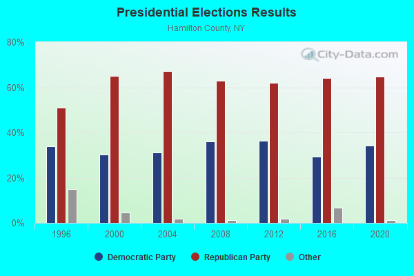
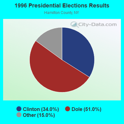
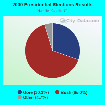
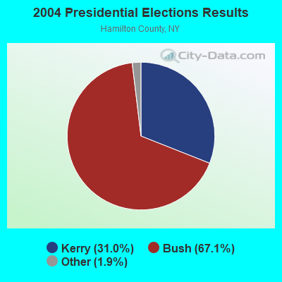
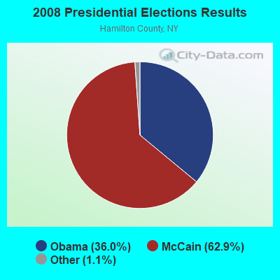
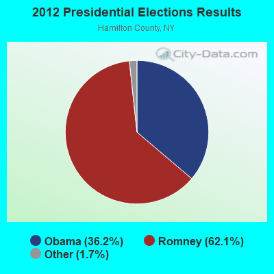
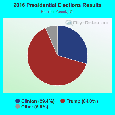
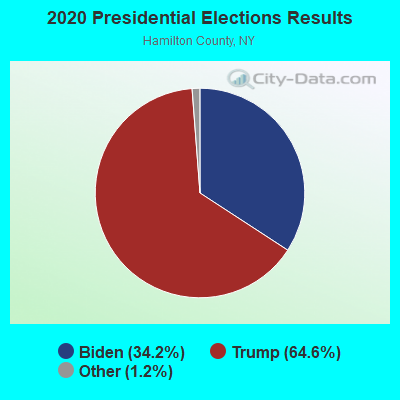
Graphs represent county-level data. Detailed 2008 Election Results
Religion statistics for Arietta, NY (based on Hamilton County data)
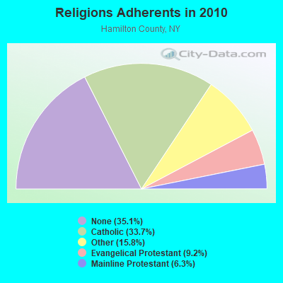
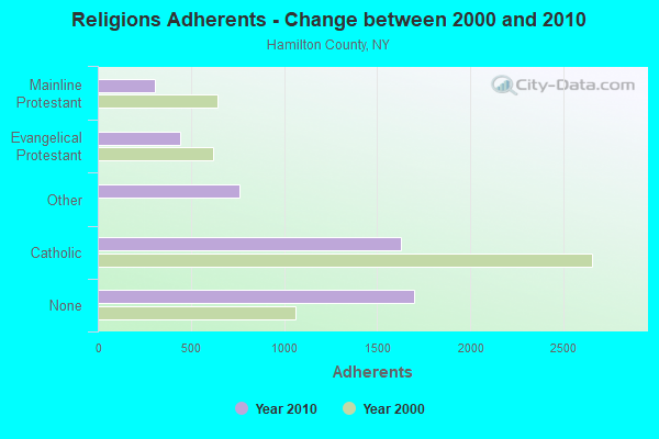
| Religion | Adherents | Congregations |
|---|---|---|
| Catholic | 1,629 | 6 |
| Other | 762 | 1 |
| Evangelical Protestant | 445 | 8 |
| Mainline Protestant | 304 | 9 |
| None | 1,696 | - |
Food Environment Statistics:
| Hamilton County: | 5.94 / 10,000 pop. |
| State: | 4.13 / 10,000 pop. |
| Hamilton County: | 15.83 / 10,000 pop. |
| New York: | 1.68 / 10,000 pop. |
| This county: | 39.57 / 10,000 pop. |
| State: | 8.82 / 10,000 pop. |
| This county: | 10.5% |
| New York: | 8.2% |
| This county: | 24.2% |
| New York: | 23.8% |
| This county: | 15.9% |
| New York: | 15.6% |
Strongest AM radio stations in Arietta:
- WGY (810 AM; 50 kW; SCHENECTADY, NY; Owner: CLEAR CHANNEL BROADCASTING LICENSES, INC.)
- WPTR (1540 AM; 50 kW; ALBANY, NY; Owner: KIMTRON, INC.)
- WNNZ (640 AM; 50 kW; WESTFIELD, MA; Owner: CLEAR CHANNEL BROADCASTING LICENSES, INC.)
- WICY (1490 AM; 50 kW; MALONE, NY; Owner: CARTIER COMMUNICATIONS INC.)
- WCHP (760 AM; 35 kW; CHAMPLAIN, NY; Owner: CHAMPLAIN RADIO, INC.)
- WADR (1480 AM; 5 kW; REMSEN, NY; Owner: CLEAR CHANNEL BROADCASTING LICENSES, INC.)
- WCRN (830 AM; 50 kW; WORCESTER, MA; Owner: CARTER BROADCASTING CORPORATION)
- WIBX (950 AM; 5 kW; UTICA, NY; Owner: REGENT LICENSEE OF UTICA/ROME, INC.)
- WMCA (570 AM; 50 kW; NEW YORK, NY; Owner: SALEM MEDIA OF NEW YORK, LLC)
- WRUN (1150 AM; 5 kW; UTICA, NY)
- WRKO (680 AM; 50 kW; BOSTON, MA; Owner: ENTERCOM BOSTON LICENSE, LLC)
- WTIC (1080 AM; 50 kW; HARTFORD, CT; Owner: INFINITY RADIO OPERATIONS INC.)
- WFAN (660 AM; 50 kW; NEW YORK, NY; Owner: INFINITY BROADCASTING OPERATIONS, INC.)
Strongest FM radio stations in Arietta:
- WXLG (89.9 FM; NORTH CREEK, NY; Owner: THE ST. LAWRENCE UNIVERSITY)
- WXLH (91.3 FM; BLUE MOUNTAIN LAKE, NY; Owner: THE ST. LAWRENCE UNIVERSITY)
- WKBE (100.3 FM; WARRENSBURG, NY; Owner: 6 JOHNSON ROAD LICENSES, INC.)
- WRGR (102.3 FM; TUPPER LAKE, NY; Owner: RADIO LAKE PLACID, INC.)
- WCKM-FM (99.1 FM; LAKE GEORGE, NY; Owner: ENTERTRONICS, INC.)
- WNYQ (105.7 FM; QUEENSBURY, NY; Owner: VOX NEW YORK, L.L.C.)
- WUCL (93.5 FM; REMSEN, NY; Owner: CLEAR CHANNEL BROADCASTING LICENSES, INC.)
- WBGK (99.7 FM; NEWPORT VILLAGE, NY; Owner: ROSER COMMUNICATIONS NETWORK, INC.)
TV broadcast stations around Arietta:
- WKTV (Channel 2; UTICA, NY; Owner: SMITH TELEVISION OF NEW YORK LICENSE HOLDINGS, INC.)
- National Bridge Inventory (NBI) Statistics
- 12Number of bridges
- 72ft / 22.4mTotal length
- $11,338,000Total costs
- 6,123Total average daily traffic
- 722Total average daily truck traffic
- 6,325Total future (year 2036) average daily traffic
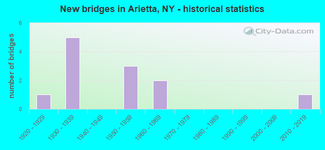
- New bridges - historical statistics
- 11920-1929
- 51930-1939
- 31950-1959
- 21960-1969
- 12010-2019
FCC Registered Broadcast Land Mobile Towers:
1- ARIETTA, State Highway 8 (Lat: 43.391972 Lon: -74.552111), Type: Ltower, Structure height: 59.4 m, Call Sign: WREL727,
Assigned Frequencies: 155.752 MHz, 151.137 MHz, 154.452 MHz, 158.737 MHz, 159.472 MHz, 453.212 MHz, 453.462 MHz, 453.712 MHz, 453.862 MHz, Grant Date: 10/29/2019, Expiration Date: 10/29/2029, Certifier: Karl Abrams, Registrant: Copper City Communications, 6333 Kolton Dr, Rome, NY 13440, Phone: (315) 292-4323, Fax: (609) 409-1927, Email:
Arietta compared to New York state average:
- Median house value below state average.
- Unemployed percentage below state average.
- Black race population percentage significantly below state average.
- Hispanic race population percentage significantly below state average.
- Median age significantly above state average.
- Foreign-born population percentage significantly below state average.
- Renting percentage significantly below state average.
- Length of stay since moving in significantly above state average.
- Number of rooms per house significantly below state average.
- House age significantly below state average.